Liberty Avenue (IND Fulton Street Line)
Liberty Avenue | |||||||||
|---|---|---|---|---|---|---|---|---|---|
|
| |||||||||
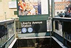
 Station entrance along the northwest corner of Pennsylvania and Liberty Avenues on the side of the Cornerstone Seventh-Day Adventist Church | |||||||||
| Station statistics | |||||||||
| Address |
Liberty Avenue & Pennsylvania Avenue Brooklyn, NY 11207 | ||||||||
| Borough | Brooklyn | ||||||||
| Locale | East New York | ||||||||
| Coordinates | 40°40′28″N 73°53′47″W / 40.674357°N 73.896489°WCoordinates: 40°40′28″N 73°53′47″W / 40.674357°N 73.896489°W | ||||||||
| Division | B (IND) | ||||||||
| Line | IND Fulton Street Line | ||||||||
| Services |
A C | ||||||||
| Transit connections |
| ||||||||
| Structure | Underground | ||||||||
| Platforms | 2 side platforms | ||||||||
| Tracks | 4 | ||||||||
| Other information | |||||||||
| Opened | November 28, 1948 | ||||||||
| Station code | 185[1] | ||||||||
| Wireless service |
| ||||||||
| Traffic | |||||||||
| Passengers (2017) |
886,011[3] | ||||||||
| Rank | 374 out of 425 | ||||||||
| Station succession | |||||||||
| Next north |
Broadway Junction: A | ||||||||
| Next south |
Van Siclen Avenue: A | ||||||||
| |||||||||
| |||||||||
| |||||||||


Liberty Avenue is a local station on the IND Fulton Street Line of the New York City Subway. It is served by the C train at all times except nights, when the A train takes over service.
Station layout
| G | Street level | Exit/entrance |
| M | Mezzanine | Fare control, station agent, MetroCard machines |
| P Platform level |
Side platform, doors will open on the right | |
| Northbound local | ← | |
| Northbound express | ← | |
| Southbound express | → | |
| Southbound local | | |
| Side platform, doors will open on the right | ||
This underground station has two side platforms and four tracks. The two center express tracks do not have any platforms. Old signs indicate “To Manhattan” and “To Richmond Hill and Ozone Park” and “Public Telephone” (phone booths were originally installed in the station[4] but have since been removed). At platform level there was a wide area under the stairways now used for storage.
Constructed beginning in 1938, this station was an unfinished shell during World War II that couldn't be completed due to material shortages from the war effort. This meant the station got a sightly different tile job and design for the mezzanine compared to the rest of the local stations along the line. This station opened on November 28, 1948 along with the rest of the Fulton Street Line east of East New York to Euclid Avenue.[5][6][7]
Exits
The exit is in the center with two stairways from each platform to a mezzanine above the platforms. The exits from the mezzanine lead to all four corners of Liberty and Pennsylvania Avenues.[8]
References
- ↑ "Station Developers' Information". Metropolitan Transportation Authority. Retrieved June 13, 2017.
- ↑ "NYC Subway Wireless – Active Stations". Transit Wireless Wifi. Retrieved May 18, 2016.
- ↑ "Facts and Figures: Annual Subway Ridership 2012–2017". Metropolitan Transportation Authority. July 12, 2018. Retrieved July 12, 2018.
- ↑ "Last Word in Subways and Cars for Boro". Brooklyn Daily Eagle. November 23, 1948. p. 8. Retrieved October 9, 2015 – via Newspapers.com.
- ↑ "Trains Roll on $47,000,000 Fulton St. Subway Extension". Brooklyn Daily Eagle. November 29, 1948. p. 2. Retrieved October 9, 2015 – via Newspapers.com.
- ↑ "Fulton Subway Stations". Brooklyn Daily Eagle. November 28, 1948. Retrieved October 9, 2015 – via Newspapers.com.
- ↑ "Last Word in Subways and Cars for Boro". Brooklyn Daily Eagle. November 23, 1948. p. 8. Retrieved October 9, 2015 – via Newspapers.com.
- ↑ "MTA Neighborhood Maps: East New York" (PDF). mta.info. Metropolitan Transportation Authority. 2015. Retrieved July 19, 2015.
External links
- nycsubway.org – IND Fulton Street Line: Liberty Avenue
- Station Reporter — C Train
- The Subway Nut — Liberty Avenue Pictures
- Liberty Avenue entrance from Google Maps Street View
- Platforms from Google Maps Street View
| Fulton St. Line |
|
|---|---|
| |