Rockaway Boulevard (IND Fulton Street Line)
Rockaway Boulevard | |||||||
|---|---|---|---|---|---|---|---|
|
| |||||||
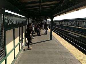 Brooklyn-bound platform after renovation | |||||||
| Station statistics | |||||||
| Address |
Rockaway Boulevard & Liberty Avenue Queens, NY 11417 | ||||||
| Borough | Queens | ||||||
| Locale | Ozone Park | ||||||
| Coordinates | 40°40′50″N 73°50′37″W / 40.680459°N 73.843703°WCoordinates: 40°40′50″N 73°50′37″W / 40.680459°N 73.843703°W | ||||||
| Division | B (IND, formerly BMT) | ||||||
| Line |
IND Fulton Street Line BMT Fulton Street Line (formerly) | ||||||
| Services |
A | ||||||
| Transit connections |
| ||||||
| Structure | Elevated | ||||||
| Platforms | 2 side platforms | ||||||
| Tracks | 3 (2 in regular service) | ||||||
| Other information | |||||||
| Opened | September 25, 1915[1] | ||||||
| Station code | 192[2] | ||||||
| Accessibility | Same-platform wheelchair transfer available | ||||||
| Traffic | |||||||
| Passengers (2017) |
2,371,645[3] | ||||||
| Rank | 208 out of 425 | ||||||
| Station succession | |||||||
| Next west |
88th Street: A | ||||||
| Next east |
104th Street (local): A Ozone Park–Lefferts Boulevard (Lefferts express): no regular service Aqueduct–North Conduit Avenue (Rockaway): A | ||||||
| |||||||
| |||||||
| |||||||


Rockaway Boulevard is a station on the IND Fulton Street Line of the New York City Subway. Located at the intersection of Rockaway Boulevard, Woodhaven and Cross Bay Boulevards, and Liberty Avenue in Ozone Park, Queens, it is served by the A train at all times.
History
Rockaway Boulevard was one of the six stations along Liberty Avenue in Queens, from 80th Street through Ozone Park–Lefferts Boulevard, as well as the current three track elevated structure, built for the BMT Fulton Street Line in 1915 as part of BMT's portion of the Dual Contracts.[1][4]
On April 8, 1928, two eastbound trains crashed in the station, killing one person and injuring 30.[5]
The connection to the BMT was severed on April 26, 1956, and the IND was extended east (railroad south) from Euclid Avenue via a connecting tunnel and new intermediate station at Grant Avenue, with the new service beginning on April 29, 1956.[4][6][7] Three months later, a connection to the IND Rockaway Line was provided on June 26, 1956, replacing the Long Island Rail Road's long troubled Rockaway Beach Branch.[8][9][10][11][12][13]
The station was completely renovated in 2015.[14]
Station layout
| P Platform level |
Side platform, doors will open on the right | |
| Northbound | ← ← | |
| Peak-direction Express | → No regular service | |
| Southbound | → → (No service: Lefferts Boulevard (Lefferts)) | |
| Side platform, doors will open on the right | ||
| M | Mezzanine | Fare control, station agent, Metrocard vending machines |
| G | Street Level | Exit/ Entrance |
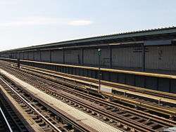
This station has two side platforms and three tracks. The center track is not used in revenue service. The platforms have beige windscreens and green and brown canopies.
This is the outermost station from Manhattan that is shared by all A train branches. Just past the east end of the platform, the line splits into two routes. Trains heading to Lefferts Boulevard continue east along Liberty Avenue, while those heading to the Rockaways diverge and turn south towards Howard Beach, Jamaica Bay, Broad Channel and the Rockaways.
Exits
This station has two station-houses with the full-time one at the west (railroad north) end. Single staircases from each platform go down to the elevated station-house beneath the tracks. Inside are a turnstile bank and token booth. Outside of fare control, two staircases lead to either side of Liberty Avenue at Woodhaven/Cross Bay Boulevard.[15]
The other station-house at the east (railroad south) end is also elevated and beneath the tracks, but unstaffed. It contains two HEET turnstiles, a staircase to each platform, and two staircases to either side of Liberty Avenue at 96th Street. The wooden staircase landings have a high exit-only turnstile to allow passengers to exit the system without having to go through the station.[15]
References
- 1 2 "New Elevated Line Opened for Queens" (PDF). The New York Times. September 26, 1915. Retrieved September 28, 2007.
- ↑ "Station Developers' Information". Metropolitan Transportation Authority. Retrieved June 13, 2017.
- ↑ "Facts and Figures: Annual Subway Ridership 2012–2017". Metropolitan Transportation Authority. July 12, 2018. Retrieved July 12, 2018.
- 1 2 Sparberg, Andrew J. (October 1, 2014). From a Nickel to a Token: The Journey from Board of Transportation to MTA. Fordham University Press. ISBN 978-0-8232-6190-1.
- ↑ "One Killed, 30 Hurt in B.M.T. Collision". The New York Times. April 8, 1928. Retrieved July 16, 2016.
- ↑ "First Leg of Rockaways Transit Opened at Cost of $10,154,702" (PDF). nytimes.com. The New York Times. April 30, 1956. Retrieved June 29, 2015.
- ↑ Freeman, Ira Henry (June 28, 1956). "Rockaway Trains to Operate Today" (PDF). nytimes.com. The New York Times. Retrieved June 29, 2015.
- ↑ "PRR Chronology, 1956" (PDF). (45.9 KiB), December 2004 Edition
- ↑ Freeman, Ira Henry (June 28, 1956). "Rockaway Trains to Operate Today" (PDF). nytimes.com. The New York Times. Retrieved 29 June 2015.
- ↑ "First Train On Rockaway Line Runs This Afternoon". Wave of Long Island. Fultonhistory.com. June 28, 1956. p. 1. Retrieved 16 August 2016.
- ↑ "First Train On Rockaway Line Runs This Afternoon". Wave of Long Island. Fultonhistory.com. June 28, 1956. p. 6. Retrieved 16 August 2016.
- ↑ "TA's New Line To Rockaways Begins Today: Fifty Piece Band To Play as Special Train Makes First Run". The Leader-Observer. Fultonhistory.com. June 28, 1956. p. 1. Retrieved 16 August 2016.
- ↑ "To Rockaways: Beach Trains In Operation". Greenpoint Weekly Star. Fultonhistory.com. June 29, 1956. p. 2. Retrieved 16 August 2016.
- ↑ http://www.ny1.com/nyc/all-boroughs/transit/2015/05/28/rockaway-boulevard-a-train-platform-to-close-for-summer-construction.html
- 1 2 "MTA Neighborhood Maps: Woodhaven" (PDF). mta.info. Metropolitan Transportation Authority. 2015. Retrieved June 30, 2015.
External links
| Wikimedia Commons has media related to Rockaway Boulevard (IND Fulton Street Line). |
- nycsubway.org – IND Fulton: Rockaway Boulevard
- Station Reporter — A Lefferts
- Station Reporter — A Rockaway
- The Subway Nut — Rockaway Boulevard Pictures
- 94th Street/Rockaway Boulevard entrance from Google Maps Street View
- 96th Street/Cross Bay Boulevard — Woodhaven Boulevard entrance from Google Maps Street View
- Platforms from Google Maps Street View
| Fulton St. Line |
|
|---|---|
| |