Camaligan, Camarines Sur
| Camaligan | |
|---|---|
| Municipality | |
| Municipality of Camaligan | |
 | |
| Nickname(s): The Small Town with a Big Heart | |
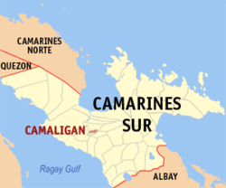 Map of Camarines Sur with Camaligan highlighted | |
.svg.png) Camaligan Location within the Philippines | |
| Coordinates: 13°37′30″N 123°09′25″E / 13.625°N 123.1569°ECoordinates: 13°37′30″N 123°09′25″E / 13.625°N 123.1569°E | |
| Country |
|
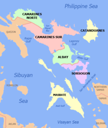
| Region | Bicol Region (Region V) |
| Province | Camarines Sur |
| District | 3rd district |
| Barangays | 13 (see Barangays) |
| Government [1] | |
| • Type | Sangguniang Bayan |
| • Mayor | Marilou Marquez-Hirose |
| • Vice Mayor | Rolando Eduardo |
| • Electorate | 13,449 voters (2016) |
| Area [2] | |
| • Total | 4.68 km2 (1.81 sq mi) |
| Population (2015 census)[3] | |
| • Total | 24,109 |
| • Density | 5,200/km2 (13,000/sq mi) |
| Time zone | UTC+8 (PST) |
| ZIP code | 4401 |
| PSGC | 051709000 |
| IDD : area code | +63 (0)54 |
| Climate type | Tropical rainforest climate |
| Income class | 5th municipal income class |
| Revenue (₱) | 58,700,476.23 (2016) [4] |
| Poverty incidence | 18.45 (2012)[5] |
| Native languages |
Central Bikol Tagalog |
Camaligan, officially the Municipality of Camaligan, is a 5th class municipality in the province of Camarines Sur, Philippines. According to the 2015 census, it has a population of 24,109 people.[3]
With an area of 468.8 hectares (1,158 acres), it is the smallest municipality in Camarines Sur, but it is the densest, having 4,755 persons per square kilometer, which is almost twice the density of the Naga City. The town is home to the oldest known pre-colonial site in the Bicol region, dating 500 AD to 600 AD, making it an undeclared important archaeological zone.[6]
Barangays
Camaligan is politically subdivided into 13 barangays.
- Gogon-Dugcal
- Marupit
- San Francisco
- San Jose-San Pablo (Poblacion)
- San Juan-San Ramon (Poblacion)
- San Lucas (Poblacion)
- San Mateo (Poblacion)
- San Marcos (Poblacion)
- San Roque
- Santo Domingo (Poblacion)
- Santo Tomas (Poblacion)
- Sua-Tampac
- Tarosanan
History
The town proper is a known archeological site. From 2016-2017, hundreds of artifacts including shells, jar fragments, tools, other deposits, pig bones, deer bones, stingray cartilage, shark cartilage, and at least 15 pre-colonial human remains were found in the area, marking a revolutionary phase in Bicolano archaeology. The shells and tools found in the town dated back 1,500 years ago or approximately 500 AD to 600 AD. The site contained no trace of Chinese, Southeast Asian, or South Asia trade links, making Camaligan a pure pre-colonial Bicolano site.[7][8]
The origin of the town and its name can be traced back to the early settlers of the place. Known as the “Canoadores” (Certadores) to the early Spanish colonizers who came to the place in the early Seventeenth Century (17th), the settlers cut timbers from nearby mountains located upriver or around San Miguel bay area and made this as their form of living. Out of these timbers they hewed out canoes or “bancas” which they stored under small sheds or huts. Later, when these sheds became abundant in the area, as they were made the permanent dwelling places by these canoe makers, the place was called “CAMALIGAN” from the word “KAMALIG” or shed, a place where so many “Kamalig” are found. The sheds served to shelter the canoe makers and protect their boats from the natural elements. Hence, the name and origin of the town is historically tied to the river and its early inhabitants.
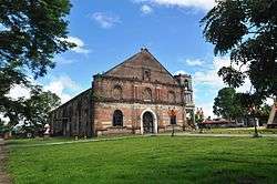
The settlers of the religious visita of Nueva Caceres, which was then under its ecclesiastical jurisdiction, arrived in the town by the 17th century. The pre-colonial cemetery and community center of the people was transformed by the Spanish into the town's current church compound to diminish native belief systems and instill Catholicism. On 5 June 1775, a petition to the Spanish religious authorities was sent by the natives and signed by the supposedly officials of the place, to request for a resident curate. The officials’ names were: Andre Casa, Diego, Lobao, Simeon de la Cruz, Manuel del Espiritu Santo, Fernando Valenzuela, Agustin del Espiritu Santo, Marcos David, Domingo Flores, Pedro Negre, Bartolome Rodriguez and Valentine de los Santos.
The official establishment of the municipality is in year 1902 through an act of the Philippine legislature. It also named Pedro Bustamante as the first (1st) Municipal Mayor. This event of the creation of the Municipality of Camaligan was brought about by a historical fact when Camaligan was eventually separated from being as annex town to Nueva Caceres now Naga City.
The people of Camaligan derived their socio-cultural identity as river people from the existence of the river. Bicol River is an important resource for irrigation and fertilization of the land where agriculture and fishing is still considered as a major industry. The place’s festivals, songs and dances found their roots and inspiration from the river. Hence, it could be said that the river ecology has bred its own distinct community.
Demographics
| Population census of Camaligan | ||
|---|---|---|
| Year | Pop. | ±% p.a. |
| 1918 | 2,133 | — |
| 1939 | 3,005 | +1.65% |
| 1948 | 7,362 | +10.47% |
| 1960 | 8,529 | +1.23% |
| 1970 | 7,821 | −0.86% |
| 1975 | 9,853 | +4.74% |
| 1980 | 10,989 | +2.21% |
| 1990 | 15,436 | +3.46% |
| 1995 | 17,411 | +2.28% |
| 2000 | 19,188 | +2.11% |
| 2007 | 20,758 | +1.09% |
| 2010 | 22,254 | +2.56% |
| 2015 | 24,109 | +1.54% |
| Source: Philippine Statistics Authority[3] [9] [10] [11] | ||
In the 2015 census, the population of Camaligan was 24,109 people,[3] with a density of 5,200 inhabitants per square kilometre or 13,000 inhabitants per square mile.
Climate
| Climate data for Camaligan, Camarines Sur | |||||||||||||
|---|---|---|---|---|---|---|---|---|---|---|---|---|---|
| Month | Jan | Feb | Mar | Apr | May | Jun | Jul | Aug | Sep | Oct | Nov | Dec | Year |
| Average high °C (°F) | 32 (90) |
31 (88) |
34 (93) |
36 (97) |
37 (99) |
37 (99) |
36 (97) |
34 (93) |
35 (95) |
34 (93) |
33 (91) |
32 (90) |
34 (94) |
| Average low °C (°F) | 27 (81) |
27 (81) |
29 (84) |
31 (88) |
32 (90) |
32 (90) |
31 (88) |
30 (86) |
30 (86) |
29 (84) |
28 (82) |
28 (82) |
30 (85) |
| Average precipitation mm (inches) | 39.34 (1.5488) |
68.7 (2.705) |
26.73 (1.0524) |
66.19 (2.6059) |
84.49 (3.3264) |
178.89 (7.0429) |
244.27 (9.6169) |
188.3 (7.413) |
160.98 (6.3378) |
445.0 (17.52) |
135.5 (5.335) |
367.8 (14.48) |
2,006.19 (78.9841) |
| Average rainy days | 16 | 18 | 13 | 15 | 23 | 28 | 30 | 24 | 26 | 27 | 25 | 29 | 274 |
| Source: World Weather Online[12] | |||||||||||||
Educational institutions
- Camaligan National High School
- Camaligan Central School
- Sua Elementary School
- Dugcal Elementary School
- San Roque Elementary School
- Marupit Elementary School
- San Francisco-Tarosanan Elementary School
- San Mateo Day Care Center
- San Marcos Day Care Center
- San Ramon Day Care Center
Archaeological Site
The town proper is the Bicol region's oldest known pre-colonial site, filled with numerous stone tools, jar fragments, shell middens, pig and deer bones, shark and ray cartilages, and other artifacts and biofacts. The site is also home to 15 human skeletons of pre-colonial Ibalons. The site is rare and vital as it does not contain any evidences of trade contact with China, Southeast Asian neighbors, or South Asia, making it one of the very few pre-colonial sites in the Philippines with distinct Filipino artifacts and biofacts unaffected by outside trade. Both the University of the Philippines and University of California, Los Angeles have been pushing for the town's declaration as an Important Archaeological Site. Scholars have also been pushing for the site's nomination in the UNESCO World Heritage List.[13][14]
In a documentary made by GMA News TV, it was found that the artifacts and biofacts were not limited to the town proper. In fact, during a road-widening project conducted in September 2017 by the national government, hundreds of human bone fragments, animal bones, burial and ceremonial jar fragments, and stone tools were found after digging only the edges of the road. The documentary also found many townfolks to own artifacts they have found in their own land. Due to these findings, the town's reputation as a vital pre-colonial Ibalon archaeological site was solidified.[15]
Festivals
- Kamalig Festival
- Kamaligang Pasko Festival
References
- ↑ "Municipality". Quezon City, Philippines: Department of the Interior and Local Government. Retrieved 31 May 2013.
- ↑ "Province: Camarines Sur". PSGC Interactive. Quezon City, Philippines: Philippine Statistics Authority. Retrieved 12 November 2016.
- 1 2 3 4 Census of Population (2015). "Region V (Bicol Region)". Total Population by Province, City, Municipality and Barangay. PSA. Retrieved 20 June 2016.
- ↑ "Camarines Sur : Cities and Municipalities Competitiveness Index". Makati City, Philippines: National Competitiveness Council (Philippines). Retrieved 29 October 2017.
- ↑ "PSA Releases the 2012 Municipal and City Level Poverty Estimates". Quezon City, Philippines: Philippine Statistics Authority. Archived from the original on 28 January 2017. Retrieved 28 January 2017.
- ↑ http://newsinfo.inquirer.net/923681/1500-yr-old-artifacts-found-in-camsur
- ↑ http://newsinfo.inquirer.net/923681/1500-yr-old-artifacts-found-in-camsur
- ↑ http://lifestyle.inquirer.net/234062/pre-hispanic-burial-ground-unearthed-in-camsur-town/
- ↑ Census of Population and Housing (2010). "Region V (Bicol Region)". Total Population by Province, City, Municipality and Barangay. NSO. Retrieved 29 June 2016.
- ↑ Censuses of Population (1903–2007). "Region V (Bicol Region)". Table 1. Population Enumerated in Various Censuses by Province/Highly Urbanized City: 1903 to 2007. NSO.
- ↑ "Province of Camarines Sur". Municipality Population Data. Local Water Utilities Administration Research Division. Retrieved 17 December 2016.
- ↑ "Camaligan, Camarines Sur: Average Temperatures and Rainfall". World Weather Online. Retrieved 29 October 2017.
- ↑ http://newsinfo.inquirer.net/923681/1500-yr-old-artifacts-found-in-camsur
- ↑ http://lifestyle.inquirer.net/234062/pre-hispanic-burial-ground-unearthed-in-camsur-town/
- ↑ https://www.youtube.com/watch?v=7WfsZivdNDg
External links
| Wikimedia Commons has media related to Camaligan, Camarines Sur. |
- Philippine Standard Geographic Code
- Philippine Census Information
- Official Site of the Province of Camarines Sur
Pili (capital) | |
| Municipalities | |
| Component city | |
| Independent component city |
|
| Administrative divisions |
|  | ||||
|---|---|---|---|---|---|---|
| Geography | ||||||
| History | ||||||
| Religion | ||||||
| Public utilities and services |
| |||||
| Transportation | ||||||
| Education | ||||||
| Landmarks | ||||||