Bus lanes in New York City
Since 1963, New York City has been using a system of bus lanes that are intended to give priority to buses, which contain more occupants than passenger and commercial vehicles. Most of these lanes are restricted to buses only at certain days and times, but some bus lanes are restricted 24/7. As of November 2017, there are 104 miles (167 km) of bus lanes within New York City.
The lanes are generally used to speed up MTA bus routes on the city's public transport system, which would be otherwise held up by traffic congestion. Bus lanes are a key component of the Select Bus Service (SBS) bus rapid transit network, improving bus travel speeds and reliability by reducing delay caused by other traffic.
Since implementation, the lanes have generally helped to increase bus reliability citywide. However, there have been controversies on the benefits of the bus lanes due to the resulting increased traffic and the methods used to enforce bus lanes during their operating hours. In 2010 the city began enforcing the rule by placing cameras that take photos and videos of violators, leading to increased reports of bus-lane violations.
Types of bus lanes
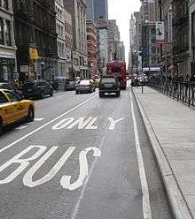
A curbside bus lane runs along the curb. Vehicles are not allowed to park or stand this lane, but may briefly enter this lane to make right turns unless otherwise specified.[1][2]
An offset bus lane is placed one lane away from the curb. In this setup, vehicles are able to park or stand at the curb, but are not allowed to double park or stop on the bus lane. Vehicles may briefly enter this lane to make right turns unless otherwise specified.[1][2]
There are also median bus lanes, which are placed in the center of the road. This setup is only used along East 161st Street in the Bronx, used by the Bx6 and Bx6 Select Bus Service routes.[3]
History
As early as 1959, the city wished to build exclusive bus lanes on Lafayette and DeKalb Avenues in Brooklyn. The lanes would be built on streets that were to be converted from two-way to one-way streets. They were intended to increase the speed of bus service on these avenues, since without the bus lanes, the routes were projected to lose riders. However, traffic commissioner T. T. Wiley disapproved of the proposal, since the city did not install exclusive bus lanes.[4]
The first two bus-lane corridors implemented in New York City were installed on May 5, 1963. One set of bus lanes was placed on Victory Boulevard in Staten Island, at the approach to the Saint George Ferry Terminal. The other set was placed on Livingston Street in Downtown Brooklyn between Boerum Street and Flatbush Avenue.[5] The same year, the city's first highway bus lane was installed on the Long Island Expressway in Long Island City, under the proposal of Traffic Commissioner Henry A. Barnes.[6] The Brooklyn bus lane soon encountered frequent traffic slowdowns, leading officials to propose adding no-parking signs and more traffic agents to enforce the lane.[7] Another bus lane was soon installed along Hillside Avenue in Queens, with the westbound bus lane extending to the subway station at 169th Street.[8]:1 In 1969, one of the most congested corridors, 42nd Street between Third Avenue and Eighth Avenue, received a rush-hour-only bus lane.[9]
Crosstown bus service on 49th and 50th Streets in Manhattan had one of the slowest speeds of those on any crosstown street in Manhattan: 3 miles per hour (4.8 km/h) (walking speed). As a result, on June 12, 1979, to speed travel, lanes were implemented to be dedicated for use by crosstown buses and taxis. Cars without a destination on this pair of streets were prohibited on weekdays from 11 a.m. to 4 p.m. between Third Avenue and Seventh Avenue. A seven-minute reduction in travel time resulted from the change.[8]:7
On May 26, 1981, the New York City Department of Transportation implemented Commissioner Sam Schwartz's plan for bus lanes on Madison Avenue. These were the first exclusive concurrent dual bus lanes on a city street.[10] Two lanes along Madison between 42nd Street and 59th Street were reserved for buses between 2 p.m. and 7 p.m on weekdays in order to reduce congestion and increase mass transit usage.[10] Twenty-nine traffic enforcement agents monitored the operation. This plan was one of three major transportation initiatives undertaken by the Koch Administration.[10] The plan was put into place after the city took a study of traffic going down Madison Avenue: 24,000 people were moved by bus, while only 11,000 moved by car between 2 p.m. and 7 p.m.. The maximum time to ride on a bus along the corridor was decreased from 36 minutes to 15 minutes. The Federal Urban Mass Transit Administration (now the Federal Transit Administration) provided a grant of $788,000 for the project.[10] While intended to only last for a year, the plan was so successful that the bus lanes were maintained. Local bus speeds increased from 2.9 miles per hour (4.7 km/h) to 4.8 miles per hour (7.7 km/h), a 65% increase. Express bus speeds increased from 2.9 miles per hour (4.7 km/h) to 5.8 miles per hour (9.3 km/h), a 100% increase. While it was expected to decrease speeds for private cars and taxis, the overall speed of traffic on the remainder of the avenue increased by 10%.[8]:6
Additional bus lanes were added in the 1970s and 1980s.[8]:1 By 1981, Manhattan alone had 12 miles (19 km) of priority bus lanes along First, Second, Third, Sixth, and Eighth Avenues; Broadway in Lower Manhattan; and 42nd and 57th Streets. Another federal grant of $575,000 allowed the city to hire 22 traffic agents to enforce bus lane rules.[11] In 1982, the city started a pilot project in which it installed red thermoplastic strips along 10 bus lanes in Manhattan. The strips were installed to remind motorists of heavy bus-lane penalties.[12]
The NYCDOT started painting bus lanes red in 2007-2008, with the introduction of Select Bus Service (SBS).[13]:1-2,5 The first bus lane that was painted red was installed on 57th Street in 2007, but the red paint was removed two years later.[13]:5 The NYCDOT chose an epoxy-based red paint for visibility reasons, but after extensive testing and review of said paint, found that the red paint was only durable when applied on newer asphalt surfaces.[13]:2 In 2010, the NYCDOT began studying other epoxy-based red paints for use on bus lanes.[13]:2-3 As a result of the study, three brands of red paint were determined to be suitable for use on New York City bus lanes.[13]:28
In 2017, the Bx6 became the first corridor to use bus lanes in the median of the street, as opposed to bus lanes on the curbside or one lane away from the curbside. The median bus lanes supposedly speed up traffic by going around double-parked cars.[3]
Notable corridors with bus lanes
The city's bus lane network is about 104 miles (167 km) long as of November 2017, representing nearly two percent of the city's 6,000 miles (9,700 km) of streets.[14][15]
Manhattan
The northbound-only First Avenue between Houston and 125th Streets, and southbound-only Second Avenue between 125th and Houston Streets, form a directional pair of bus lanes used by the M15 corridor. The bus lanes are used by both the M15 local and SBS routes.[16][17] Northbound-only Third Avenue between 36th and 58th Streets, and southbound-only Lexington Avenue (southbound, between 30th and 96th Streets, is another directional pair hosting the M101, M102, M103, and M98 bus routes.[16][17]

The two bus lanes of southbound-only Fifth Avenue carry the M1, M2, M3, M4, and M5.[16][17] They form a directional pair with the two northbound-only Madison Avenue bus lanes between 42nd and 59th Streets, which carry the M1, M2, M3, and M4.[16][17] Northbound Sixth Avenue between 40th and 57th Streets, carrying the M5 and M7, is a directional pair with southbound Seventh Avenue, whose bus lane between 23rd and 42nd Streets) is used by the M7 and M20.[16][17] For the M20, Seventh Avenue is also a directional pair with northbound Eighth Avenue between 42nd and 57th Streets.[16][17]
Bus lanes also exist on all of the major crosstown streets in Midtown Manhattan. The bidirectional bus lanes on 23rd Street, carrying the M23 SBS and various express routes, stretch across almost the entire length of the street, with the westbound lane running between 1st and 8th Avenues and the eastbound lane between 10th and 2nd Avenues.[18][17] On 34th Street, both lanes run between 11th and 1st Avenues, serving the M34 and M34A SBS buses as well as westbound express routes.[16][17] Eight blocks north, 42nd Street's lanes between Dyer and 3rd Avenues carry mainly the M42.[16][17] 57th Street's bus lanes between 8th and 2nd Avenues are used by the M31, M57, and various eastbound express routes.[16][17]
Uptown, the M79 SBS corridor employs short segments of "queue jump" bus lanes on parts of 79th and 81st Streets in order to enable buses to jump to the front of traffic at several signalized intersections.[19][20] 86th Street also uses queue-jump lanes for the M86 SBS corridor.[21][22] In Harlem, 125th Street's crosstown bus lanes between Lenox and 2nd Avenues carries the M60 SBS, M100, M101, and Bx15 routes at various points.[17][23][24][25] In Washington Heights, 181st Street has bus lanes between Broadway and 9th Avenue to funnel Bronx bus routes into the George Washington Bridge Bus Station. The 181st Street lanes carry the Bx3, Bx11, Bx13, Bx35, and Bx36 routes.[16][17] In Inwood, the 207th Street lanes between Broadway and Amsterdam Avenue carry the Bx12 and Bx12 SBS routes.[16][17]
In Lower Manhattan, there is one directional pair of bus lanes. Southbound Broadway contains a bus lane between Bowling Green and Houston Street, which carries the M55 and Staten Island express routes. Northbound Church Street, between Battery Place and Warren Street, carries these same routes one block west of Broadway.[16][17]
There are short bus lanes for various destinations around Manhattan. The southbound bus lane on 11th Avenue between 37th and 42nd Streets serves buses entering the Jacob K. Javits Convention Center, as well as the M12 route.[16][17] Bus lanes also exist at several major crossings, including 60th Street (for the Queensboro Bridge) and the Holland Tunnel.[16] Additionally, there is one non-MTA bus lane in Manhattan. In northern Harlem, Convent Avenue between 135th and 145th Streets carry school buses headed for the City College of New York. No MTA buses use these lanes since the discontinuation of the M18 bus in 2010 eliminated MTA bus service on Convent Avenue.[16]
The Bronx
The Bronx has three major sets of bus lanes. The north-south Webster Avenue lanes between 166th Street and Gun Hill Road serve the Bx41 and Bx41 SBS routes.[26][27] The crosstown lanes on Fordham Road and Pelham Parkway, between Sedgwick Avenue and Stilwell Avenue, are used by the Bx12 and Bx12 SBS.[16][26] There is also a bus lane corridor on East 161st Street used by the Bx6 and Bx6 SBS,[26] consisting of two main parts: an eastbound-only lane in the center roadway and tunnel from Yankee Stadium to Sheridan Avenue,[28] and a center bus lane from Sheridan to Morris Avenues.[3] Additionally, there is a bus lane on East 163rd Street from Tiffany Street to Southern Boulevard.[29]
Queens
In Jamaica, Archer Avenue between Sutphin and Merrick Boulevards carries routes leading to Jamaica Center or 165th Street Bus Terminal. The vast majority of routes run eastbound along Archer Avenue,[30] but bus lanes run in both directions along the avenue.[16] One block north, Jamaica Avenue's lanes between Sutphin Boulevard and 168th Street carry bidirectional bus traffic, but about half of routes use only the westbound bus lane.[16][30] A longer set of bus lanes in northern Jamaica, on Hillside Avenue between Merrick and Francis Lewis Boulevards, carry the Q1, Q36, and Q43.[16][30]
North-south lanes in Queens run along two corridors. Main Street between Northern Boulevard and Horace Harding Expressway hosts the Q20A/B and Q44 SBS.[30][31][32] Further to the west, Woodhaven Boulevard, carrying the Q11, Q21, Q52 SBS, and Q53 SBS,[30] contains bus lanes between Queens Boulevard and Metropolitan Avenue,[33][34] as well as between Union Turnpike and 81st Road.[35]
In March 2018, the New York City Department of Transportation announced that a short bus lane for the Q60 would be installed as part of the capital reconstruction of Queens Boulevard for Vision Zero's Great Streets program. As part of the plan, the Q60 will be moved to the median of Queens Boulevard between Roosevelt Avenue and 73rd Street. The bus lane will be located in the median at 69th Street heading eastbound. In addition, bus-only queue-jump bus stops with boarding islands will be added at 65th Place.[36]
Queens also has one combined bus/HOV lane in the Manhattan-bound direction. during morning rush hours only. The lane exists on the Long Island Expressway west of Calvary Cemetery. The bus lane extends to the Manhattan portal of the Queens–Midtown Tunnel.[16] It serves most Queens-to-Manhattan express buses.[30]
Brooklyn
In Downtown Brooklyn, there are two major corridors with bus lanes. Fulton Mall and Fulton Street contain a bus lane in each direction between Boerum Place and South Oxford Street, with buses having exclusive use of the Fulton Mall west of the Flatbush Avenue Extension. The Fulton corridor is used by the B25, B26, B38, and B52.[16][37] One block south of Fulton are the Livingston Street bus lanes, which run between Boerum Place and Flatbush Avenue. These are served by the B41, B45, B67, and B103.[16][37]
.jpg)
Three major corridors also contain bus lanes to facilitate SBS operations. Southbound Nostrand Avenue contains one bus lane between Flushing Avenue and Flatbush Avenue, carrying B44 and B44 SBS.[37][38][39] Rogers Avenue between Flatbush and Flushing Avenues was also retrofitted with a northbound bus lane,[39] serving the B44 SBS and B49 in that direction.[37] Bus lanes were also installed on the extreme south end of Nostrand Avenue between Avenue X and Emmons Avenue.[39] Additionally, the Utica Avenue corridor had bus lanes between Carroll Street and Eastern Parkway prior to the implementation of Select Bus Service on the B46 in 2016.[16][37] The avenue also gained lanes from St. Johns Place and Church Avenue in 2014,[40][41][42][43] which were extended to Fillmore Avenue in 2015.[44] In 2018, as part of the implementation of B82 Limited route to Select Bus Service, a section of Kings Highway between East 23rd Street and Avenue K was equipped with two bus lanes.[45]
The borough also has shorter bus lanes to facilitate operations at key destinations. On eastbound Oriental Boulevard between Jaffrey and Norfolk Streets in Sheepshead Bay, a bus lane for Kingsborough Community College serves the B1 and B49 routes.[16][37] In Canarsie, Rockaway Parkway has a bus lane between Glenwood Road and Flatlands Avenue for B42 buses making connections with the Canarsie-Rockaway Parkway subway station.[16][37] In Prospect Heights, Flatbush Avenue has bus lanes at Grand Army Plaza, which host the B41 service.[16][37]
Brooklyn also has one combined bus/HOV lane in the Manhattan-bound direction. during morning rush hours only. The lane exists on the Gowanus Expressway north of the Verrazano-Narrows Bridge. The bus lane extends to the Manhattan portal of the Brooklyn–Battery Tunnel.[16] It serves most Staten Island-to-Manhattan express buses.[37][46]
Staten Island
Staten Island has four major bus lane corridors. Hylan Boulevard's bus lanes host the S78, S79 SBS, and numerous express routes between Steuben Street and Midland Avenue. South of Hylan Boulevard, Father Capodanno Boulevard also has bus lanes in the northbound direction between Midland and Lily Pond Avenues, which are used by the S51, S52, S81, and some express routes.[16][46] Richmond Avenue's north-south lanes appear in two places: near the Staten Island Mall and near Hylan Boulevard. They are mainly utilized by the S59, S79 SBS, and S89, as well as some express routes.[46][47] Finally, Victory Boulevard has bus lanes between Forest Avenue and Bay Street, which are used by the S46, S48, S61, S62, S66, S91, S92, S96, and S98.[16][46]
Staten Island also has a combined bus/HOV lane on the Staten Island Expressway in each direction from Victory Boulevard to the Verrazano-Narrows Bridge.[48] It serves most Staten Island-to-Manhattan express buses.[46]
Rules
Emergency vehicles and buses, including non-MTA buses such as school buses and charter buses, are the only vehicles with unrestricted access to the bus lane during the hours that the bus lane is in effect.[2] During that time, it is permitted to enter a bus lane and drive for a maximum of 200 feet (61 m) in order to make an immediate right turn, or to enter a driveway.[1][2] It is also permitted to be in the bus lane to actively engage in curbside parking.[1][2] Finally, delivery trucks can enter bus lanes to make drop-offs or pick-ups at residences or businesses, but only when bus lanes are not in effect.[2]
Enforcement
In 2010, the city gained authorization from the state to begin placing hidden traffic cameras on gantries above the bus lanes. The cameras take photos of the vehicles driving through the bus lane, along with their license plates. A fine of $115 to $150 is then mailed to the registrant's address.[1][2][49] The New York City Police Department also enforces the bus lanes by issuing parking and moving violations to violators.[1] In 2014, according to the Independent Budget Office, 3⁄4 of bus lane violations were captured on camera, contributing to $41 million worth of traffic violations captured by traffic cameras in that year.[50]
Automated cameras have advantages over manual police enforcement because they don't make errors, are not disputable, free the police for more important issues, and add revenue to the city without the cost of human officers. However, there were cases where the cameras were reported to be used as traps and the legitimacy was disputed.[51] Another disadvantage was that some drivers received violations for momentarily entering the bus lane to avoid a collision, or taking too long to exit the bus lane as a result of traffic jams.[52]
Prior to installing the bus lane cameras, there were disputes between the MTA and the City of New York over who will get the revenue from the tickets. At first the MTA refused to allow the cameras until the city would agree to split the revenue.[53][54] The city regularly reports revenue from violations issued by the automated cameras.[51] In one instance a camera issued nearly 7,200 violations in a two-month period, translating to an average of 115 tickets a day, and raising about $823,000 in fine revenue.[51]
Benefits
Bus lanes have generally increased average bus speeds and reduced travel times where they are installed. For instance, after bus lanes were installed along East 125th Street in East Harlem in 2014, the average speeds of the M60 Select Bus Service route along that segment increased 32% to 34%, and the average speeds of the M100 and Bx15 local buses increased 7% to 20%.[55]:9,14 By contrast, along West 125th Street where bus lanes were not initially installed, there was no marked increase in local bus speeds.[55]:15 The speeds of M60 SBS buses increased 27% to 36%, but only as a result of other improvements such as off-board fare payment and fewer stops.[55]:10,13 Another corridor, Fordham Road in the Bronx, saw a 14% to 24% increase in average bus speeds on the Bx12 route after bus lanes were installed.[56]
Controversies
While bus lanes reduce the time for bus commuters, it creates traffic jams and increases travel time for other vehicles. On one bus lane, some drivers reported that travel times had more than doubled, and residents reported increased honking and pollution, despite a study by the NYCDOT indicating that there would not be increased traffic for other vehicles.[57] The cameras allow for a temporary stop to pick up/drop off passengers at curbside bus lanes, but cab drivers are concerned that customers may take longer than usual to arrange payment, which may result in a fine.[49] The installation of bus lanes reduced the amount of on-street parking in some areas, in turn potentially forcing the closures of businesses.[56]
In one incident in 2014, the city delayed mailing out the violations for a few months, causing violators to receive multiple tickets that added up to as much as $7,000.[58] According to one commentator for The New York Times, this did not serve the purpose of the cameras, which were to educate drivers and keep the bus lanes empty of cars.[49] The city agreed to review the violations and to keep each driver liable only for the first violation they received.[58] There was a bus lane camera on Staten Island that gave tickets to drivers who failed to make an immediate right turn, even though it was not possible to make the right turn, since the next possible turn was a private driveway or a one-way street that had traffic running in the opposite direction. One retired police officer showed that his ticket was withheld by the judge and the appeals system. The city eventually turned off the camera.[51][59]
See also
- Select Bus Service – a MTA bus route variant that uses exclusive bus lanes
References
- 1 2 3 4 5 6 New York City. "Bus Lane Rules". New York City. Retrieved March 4, 2015.
- 1 2 3 4 5 6 7 "5 Things You Should Know About New York City Bus Lanes" (PDF). nyc.gov. New York City Department of Transportation. Retrieved April 4, 2016.
- 1 2 3 Martinez, Jose (October 5, 2017). "Bronx SBS ride is the first to travel through center of streets". NY1. Charter Communications. Retrieved October 8, 2017.
- ↑ "SEPARATE BUS LANE ASKED IN BROOKLYN". The New York Times. February 2, 1959. ISSN 0362-4331. Retrieved July 21, 2017.
- ↑ Stengren, Bernard (May 5, 1963). "Rush-Hour Bus Lanes Assigned In Brooklyn and Staten Island" (PDF). The New York Times. ISSN 0362-4331. Retrieved July 21, 2017.
- ↑ "X-Way Equipped with "Brain"". fultonhistory.com. Long Island Star-Journal. July 15, 1963. p. 6. Retrieved July 20, 2017.
- ↑ "OFFICIALS DIFFER ON BUS-LANE JAM; Barnes Asks Enforcement, Not Signs, in Brooklyn" (PDF). The New York Times. June 12, 1963. ISSN 0362-4331. Retrieved July 21, 2017.
- 1 2 3 4 "NEW YORK, NEW YORK BUS LANES AND LIMITED-STOP SERVICE" (PDF). trb.org. 2001. Retrieved July 18, 2017.
- ↑ "Midtown Bus Lanes Set" (PDF). The New York Times. June 20, 1969. ISSN 0362-4331. Retrieved July 21, 2017.
- 1 2 3 4 Goldman, Ari L. (May 26, 1981). "2 LANES ON MADISON AVE TO BE; RESERVED FOR BUSES". The New York Times. ISSN 0362-4331. Retrieved July 18, 2017.
- ↑ Dunlap, David W. (September 3, 1981). "U.S. AIDING CITY IN IMPROVEMENT OF ITS BUS LANES". The New York Times. ISSN 0362-4331. Retrieved July 21, 2017.
- ↑ Goldman, Ari L. (June 15, 1982). "BUS-ONLY LANES TO BE INCREASED TO SPEED TRAVEL". The New York Times. ISSN 0362-4331. Retrieved July 21, 2017.
- 1 2 3 4 5 Carry, William; Donnell, Eric; Rado, Zoltan; Hartman, Martin; Scalici, Steven (February 2012). "RED BUS LANE TREATMENT EVALUATION" (PDF). nacto.org. Retrieved July 18, 2017.
- ↑ Rubinstein, Dana (October 20, 2017). "With faster buses, de Blasio promises to ease life in a 'tough city'". Politico PRO. Retrieved March 9, 2018.
- ↑ Stringer, Scott M. "The Other Transit Crisis: How to Improve the NYC Bus System". Office of the New York City Comptroller Scott M. Stringer. Retrieved March 9, 2018.
- 1 2 3 4 5 6 7 8 9 10 11 12 13 14 15 16 17 18 19 20 21 22 23 24 25 26 27 28 29 "Bus Lanes in New York City" (PDF). nyc.gov. New York City Department of Transportation. Retrieved April 4, 2016.
- 1 2 3 4 5 6 7 8 9 10 11 12 13 14 15 "Manhattan Bus Map" (PDF). Metropolitan Transportation Authority. December 2017. Retrieved April 24, 2018.
- ↑ Rajamani, Maya (August 25, 2016). "Select Bus Service Lanes Along 23rd Street Painted by City Ahead of Launch". DNAinfo New York. Archived from the original on September 17, 2016. Retrieved September 7, 2016.
- ↑ "M79 Select Bus Service - Manhattan Community Board 7" (PDF). nyc.gov. Metropolitan Transportation Authority, New York City Department of Transportation. March 22, 2017. Retrieved July 18, 2017.
- ↑ "M79 Select Bus Service - Manhattan Community Board 8" (PDF). nyc.gov. Metropolitan Transportation Authority, New York City Department of Transportation. March 1, 2017. Retrieved July 18, 2017.
- ↑ "M86 Select Bus Service - Manhattan Community Board 7" (PDF). nyc.gov. Metropolitan Transportation Authority, New York City Department of Transportation. February 10, 2015. Retrieved July 18, 2017.
- ↑ "M86 Select Bus Service - Manhattan Community Board 8" (PDF). nyc.gov. Metropolitan Transportation Authority, New York City Department of Transportation. February 4, 2015. Retrieved July 18, 2017.
- ↑ "Transit & Bus Committee Meeting February 2014" (PDF). Metropolitan Transportation Authority. February 2014. Archived from the original (PDF) on February 24, 2014. Retrieved February 23, 2014.
- ↑ Solmonow, Seth. "NYC DOT, MTA and State Sen. Perkins Announce 125th St. Select Bus Service to Start in April 2014, Streetscape Improvements to be Installed Along the Entire Corridor". nyc.gov. New York City Department of Transportation. Retrieved October 12, 2013.
- ↑ "LaGuardia Airport Access Alternatives Analysis Public Meeting #1" (PDF). nyc.gov. Metropolitan Transportation Authority, New York City Department of Transportation, Port Authority of New York and New Jersey. June 22, 2011. Retrieved December 24, 2015.
- 1 2 3 "Bronx Bus Map" (PDF). Metropolitan Transportation Authority. September 2017. Retrieved April 24, 2018.
- ↑ "Bus Rapid Transit – Webster Avenue". nyc.gov. New York City Department of Transportation. June 30, 2013. Retrieved April 4, 2016.
- ↑ Small, Eddie (March 30, 2017). "DOT Plans to Put Bus-Only Lane in E. 161st Street Tunnel to Fight Traffic". DNAinfo New York. Archived from the original on October 9, 2017. Retrieved October 8, 2017.
- ↑ "Commuters, officials disagree on bus traffic solution". News 12 The Bronx. August 4, 2017. Retrieved March 10, 2018.
- 1 2 3 4 5 6 "Queens Bus Map" (PDF). Metropolitan Transportation Authority. December 2017. Retrieved April 24, 2018.
- ↑ "Flushing To Jamaica Select Bus Service: January 22, 2015: Public Open House" (PDF). nyc.gov. Metropolitan Transportation Authority, New York City Department of Transportation. January 22, 2015. Retrieved July 6, 2015.
- ↑ "Flushing to Jamaica Select Bus Service Public Workshop October 7, 2014" (PDF). nyc.gov. Metropolitan Transportation Authority, New York City Department of Transportation. October 7, 2014. Retrieved January 4, 2016.
- ↑ "Woodhaven / Cross Bay Boulevard (Q52/53) Community Advisory Committee Meeting #5" (PDF). nyc.gov. Metropolitan Transportation Authority, New York City Department of Transportation. December 15, 2015. Retrieved December 26, 2015.
- ↑ "Woodhaven / Cross Bay Boulevard (Q52/53) Public Design Workshop: Woodhaven Blvd from Union Tpke to Rockaway Blvd" (PDF). nyc.gov. Metropolitan Transportation Authority, New York City Department of Transportation. April 16, 2015. Retrieved December 28, 2015.
- ↑ "What's Happening Here?" (PDF). nyc.gov. New York City Department of Transportation. September 2017. Retrieved September 6, 2017.
- ↑ "QUEENS BOULEVARD ROOSEVELT AVE TO 73RD ST Great Streets Capital Presentation to Community Board 2 Transportation Committee March 5th, 2018" (PDF). nyc.gov. New York City Department of Transportation. March 5, 2018. Retrieved March 9, 2018.
- 1 2 3 4 5 6 7 8 9 "Brooklyn Bus Map" (PDF). Metropolitan Transportation Authority. November 2017. Retrieved April 24, 2018.
- ↑ "Nostrand Ave. Trolley Makes Way for MTA New York City Transit Select Bus Service". mta.info. Metropolitan Transportation Authority. October 10, 2013. Retrieved July 2, 2015.
- 1 2 3 "+selectbusservice B44 SBS on Nostrand Avenue Progress Report" (PDF). www.nyc.gov. New York City Department of Transportation, New York City Transit. June 2016. Retrieved July 7, 2016.
- ↑ "Utica Avenue Select Bus Service". NYC.gov.
- ↑ "Transit & Bus Committee Meeting May 2015" (PDF). Metropolitan Transportation Authority. May 2015. Retrieved January 19, 2016.
- ↑ "Utica Avenue Community Advisory Committee Meeting #2: February 4, 2015" (PDF). nyc.gov. Metropolitan Transportation Authority, New York City Department of Transportation. February 4, 2015. Retrieved January 18, 2016.
- ↑ "B46 Select Bus Service Community Board 3 Town Hall: May 11, 2015" (PDF). nyc.gov. Metropolitan Transportation Authority, New York City Department of Transportation. May 11, 2015. Retrieved January 18, 2016.
- ↑ "B46 Select Bus Service Community Board 18: February 17, 2016" (PDF). nyc.gov. Metropolitan Transportation Authority, New York City Department of Transportation. February 17, 2016. Retrieved February 23, 2016.
- ↑ "B82 Select Bus Service May 9, 2017" (PDF). nyc.gov. May 9, 2017. Retrieved May 12, 2017.
- 1 2 3 4 5 "Staten Island Bus Map" (PDF). Metropolitan Transportation Authority. August 2018. Retrieved August 18, 2018.
- ↑ "Bus Rapid Transit – Hylan Boulevard". nyc.gov. Metropolitan Transportation Authority, New York City Department of Transportation. September 2, 2012. Retrieved April 4, 2016.
- ↑ "Staten Island Expressway Bus/HOV Lane Extension Project" (PDF). New York City Department of Transportation. Retrieved February 19, 2018.
- 1 2 3 HUGHES, C. J. (November 22, 2010). "Cameras Monitor Trespassing in Bus Lanes". New York Times. Retrieved March 4, 2015.
- ↑ Rivoli, Dan (January 30, 2016). "NYC will crack down on drivers using Harlem bus lane". NY Daily News. Retrieved April 4, 2016.
- 1 2 3 4 Editorial (July 31, 2014). "Bus lane cameras are a 'reversible error'". Slive.com. Slive.com. Retrieved March 4, 2015.
- ↑ Editorial (October 14, 2013). "Ticket burden on the DOT: Bus lane cameras mistakenly cited law-abiding drivers on Staten Island". Slive.com. Retrieved March 4, 2015.
- ↑ Kabak, Benjamin (June 14, 2012). "Reaping the spoils of bus lane enforcement". 2nd Avenue Sagas. Retrieved March 4, 2015.
- ↑ Susan (June 12, 2012). "MTA wants to share revenues from bus lane tickets". The Transit Wire. Retrieved March 4, 2015.
- 1 2 3 "M60 Select Bus Service on 125th Street" (PDF). nyc.gov. Community Board 10 Transportation Committee; Metropolitan Transportation Authority. April 14, 2015. Retrieved July 18, 2017.
- 1 2 Samuels, Tanyanika (October 6, 2008). "Business tossed under the (express) bus". NY Daily News. Retrieved July 18, 2017.
- ↑ Sharp, Sonja (January 13, 2014). "Crown Heights, Prospect Heights & Prospect-Lefferts GardensTransportation Brooklyn's New B44 Express Bus Causes Traffic Nightmare, Residents Say". DNAinfo. Archived from the original on April 2, 2015. Retrieved March 4, 2015.
- 1 2 Ned, Berke (July 29, 2014). "City Agrees To Nix Nostrand Ave Bus Lane Violations After Finding Backlog – Here's How To Fight Your Ticket". SHEEPSHEAD BITES. Retrieved March 4, 2015.
- ↑ MOCKERPIX11 AND GREG MOCKER (September 5, 2013). "Bus lane camera in NYC turned off after drivers complain". PIX 11. Retrieved March 4, 2015.
External links
| Wikimedia Commons has media related to Bus lanes in New York City. |
| Routes |  .jpg) | |
|---|---|---|
| Fleet | ||
| Transit hubs | ||
| Other | ||