Staten Island light rail
Staten Island light rail proposals refer to two projects in the New York City borough of Staten Island. These proposals are among the several light rail projects that have been floated in New York City in recent years.[1] Neither proposal was funded in the Metropolitan Transportation Authority's 2015–2019 Capital Plan,[2] but $4 million was allocated to a study for it.[3]
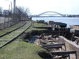
North Shore
The North Shore Light Rail line is a proposed rail line (since turned into a bus rapid transit line) serving the northern portion of Staten Island along the abandoned right of way of the former Staten Island Railway's North Shore Branch. According to PlanNYC.org, which is affiliated with the Robert F. Wagner Graduate School of Public Service at New York University, "[t]he proposed five mile route, which would connect Arlington and the St. George Ferry Terminal, would cost $360 million, with funding coming from federal, state and local agencies. In order to move forward, the project will require a $4 million allocation from Congress for a feasibility study which is currently awaiting approval from the House Transportation Committee.[4] A projection of 11,000–15,000 daily passengers would ride on the North Shore Light Rail if and when it is complete.[5] This line would serve the North Shore, and would be connected with new developments such as the New York Wheel.[6]
An option that was considered was light rail transit, due to its ability to operate with cars in mixed traffic. There was a plan to run the line down South Avenue from the Arlington station to the Teleport. The line would rise to street level at Arlington. Due to freight trains laying up as far west as Union Avenue, the line would have to be physically separate from the freight line or the cars would have to be built to a higher crash standard. Comments included begin raising the line at Union Avenue, since it would have to go to street level anyway, to avoid interference with the freight line.
Some advocates of improved mass transit on the island oppose the plan, however, preferring instead the option of through service between Arlington and Tottenville via the existing Staten Island Railway, this made possible by the installation of the Ball Park loop in 2001 (since discontinued but still intact).
A 2012 alternatives analysis identified bus rapid transit (Select Bus Service) rather than light rail as the preferred alternative for the region.[7] The bus service was eventually selected.[2] About $356 million is needed to complete the line, which will run on the North Shore Branch right-of-way, adjacent to the Kill van Kull.[6] $5 million was allocated in the 2015–2019 Capital Program for environmental and design work.[3] In July 2018, the MTA indicated that it was retaining a consultant to advise on an environmental impact assessment for the bus rapid transit line on the North Shore Branch.[8]
West Shore and Kill van Kull
The West Shore Light Rail is another proposed light rail project, which is 13.1 miles (21.1 km) long,[6] and is being championed by the Staten Island Economic Development Corporation (SIEDC). Many Staten Island residents endure very long commutes into Manhattan, and the West Shore Light Rail project would lessen this for many commuters. Beginning at the South Shore, probably near a park-and-ride in Pleasant Plains, the proposed line would run along the western shore of Staten Island. It would cross into Bayonne, New Jersey, and go over the Bayonne Bridge to connect to Hudson-Bergen Light Rail.
Construction of this line could begin as soon as 2018,[2] and serve the new Freshkills Park, but SIEDC needs $5 million in funding to complete studies for the route of the line;[6] a campaign to raise the $5 million failed previously, but was restarted in August 2014.[9] The line would serve 9,000 more Staten Island workers, 65,000 more Staten Island residents, and 25,000 more households.[6] As part of the 2015–2019 MTA Capital Program, $4 million has been allocated for the alternative analysis of light rail on the West Shore of Staten Island.[3]
Kill van Kull transit
In September 2007, bus service S89 was introduced between Richmond Avenue in Staten Island and the 34th Street station.[10] As of April 2011, weekday peak limited stop service from Staten Island terminates at 34th Street with a connection to the Hudson-Bergen Light Rail to Exchange Place.[11]
The Bayonne Bridge was originally built to accommodate two extra lanes that could be used for light rail service. The Port Authority of New York and New Jersey has announced plans to raise the roadbed of the bridge by 64 feet (20 m), in order to provide the 215-foot (66 m) clearance required by the newer post-Panamax container ships to pass under it. While not having begun any studies, New Jersey Transit is investigating the feasibility of extending HBLR from the 8th Street Station across the raised bridge.[12] It is not clear whether or not such a system would fall under the supervision of the Metropolitan Transportation Authority, although this is likely. Completing any such extension would involve a collaboration between New Jersey Transit, New York State, and New York City.[13] The development of a Staten Island light rail system which could to connect with the HBLR system has gained political support in New York.[5][14][15][16] US Senator Robert Menendez supported the HBLR extension conceptually, but questioned the benefit for New Jersey.[17]
Another proposal for transit over the Kill van Kull is an aerial gondola connecting Bayonne and the North Shore.[18]
West Shore alignment
There are several route alignments that the light rail could take on the West Shore. One route would have sent the track along the Martin Luther King Expressway and Victory Boulevard to a track along Richmond Avenue. A second route would send the track along the Dr. Martin Luther King Expressway to the Staten Island Expressway to the median of the West Shore Expressway (this alignment was ultimately selected in March 2009). A third route alignment would have sent the track on the North Shore rail right-of-way to the Travis Branch of the line, and from there, onto the median of the West Shore Expressway. A fourth plan calls for the light rail to continue along the never-built yet never-demapped section of the Martin Luther King Expressway to Hylan Boulevard and Buffalo Street, whereupon it could terminate inside Great Kills Park.
See also
References
- ↑ "Reality check for Staten Island's rail plans". SILive.com. Retrieved September 28, 2014.
- 1 2 3 "North Shore Bus Rapid Transit and West Shore Light Rail projects excluded from MTA's $32B capital plan". SILive.com. Retrieved September 28, 2014.
- 1 2 3 "MTA Capital Program 2015-2019 Renew. Enhance. Expand.Amendment No. 2 As Proposed to the MTA Board May 2017" (PDF). mta.info. May 24, 2017. Retrieved May 24, 2017.
- ↑ "Staten Island North Shore Light Rail". PlanNYC.org. Retrieved September 11, 2006.
- 1 2 "Schumer Throws Support Behind S.I. Light Rail System". NY1.com. June 18, 2006. Retrieved September 11, 2006.
- 1 2 3 4 5 "Frustrations, and desperate demands for more public transportation $$ on Staten Island as MTA shapes capital plan". SILive.com. Retrieved September 28, 2014.
- ↑ "North Shore Alternatives Analysis" (PDF). MTA NYC Transit. May 2012. Retrieved May 13, 2012.
- ↑ "Transit & Bus Committee Meeting" (PDF). Metropolitan Transportation Authority. July 23, 2018. pp. 185–186. Retrieved July 23, 2018.
- ↑ "Campaign to Bring Light Rail to Staten Island Restarts". DNAinfo New York. Archived from the original on August 26, 2014. Retrieved September 28, 2014.
- ↑ "MTA NYC Transit Adds Bus Service from Staten Island to Hudson Bergen Light Rail, Advances MTA Commitment to Seamless Regional Transportation". MTA. July 16, 2007.
- ↑ "MTA NYCT bus schedule S89 per 04-2011" (PDF). Archived from the original (PDF) on March 13, 2009.
- ↑ "Hudson-Bergen Light Rail may be extended over the Bayonne Bridge to Staten Island". Newark Star-Ledger. January 13, 2011.
- ↑ "Cutting it close: Bayonne Bridge's height is trouble for ships and a costly question for the Port Authority". Wired New York. May 19, 2006.
- ↑ "Staten Island North Shore and West Shore Light Rails". www.plannyc.org. Archived from the original on July 20, 2011. Retrieved May 15, 2011.
- ↑ Wrobleski, Tom (January 13, 2011). "Staten Island congressman wants Port Authority to build light rail link across Bayonne Bridge". Retrieved May 15, 2011.
- ↑ "A Light Rail Extension for Staten Island?". The Transport Politic. January 17, 2011. Retrieved May 15, 2011.
- ↑ "Menendez likes idea of HBLR extension into Staten Island but wants specifics: Editorial Board video". Newark Star-Ledger. January 27, 2011.
- ↑ McDonald, Corey W. (October 14, 2017). "Could an aerial gondola connect Staten Island and Bayonne?". The Jersey Journal. Retrieved October 14, 2017.
Further reading
- Restoring Staten Island's Rail Connections
- Borough President Molinaro to MTA: "light rail users strongly support Bayonne bus service"
- Yates, Maura & Rich, Kiawana (March 16, 2009). "Staten Island light-rail line detailed". Staten Island Advance. Retrieved March 27, 2009.
- Gordon, Cameron E.; Bajrami, Bukurije; Santiago, Nóra Tábori; Peters, Jonathan (2013). "A Bridge Too Far? The Staten Island/Hudson-Bergen Light Rail Missed Connection" (PDF). Journal of Public Transportation. 16 (3): 1–22. doi:10.5038/2375-0901.16.3.1.
External links
- West Shore Light Rail Project—description from the Staten Island Economic Development Corporation
- http://www.auto-free.org/lrt-staten.html