Roosevelt Island Tramway
| Roosevelt Island Tramway | |
|---|---|
 | |
| Overview | |
| Status | Operational |
| Character | Aerial tramway |
| System | Pomagalski |
| Location | Manhattan, New York City, U.S. |
| Termini |
Upper East Side (west) Roosevelt Island (east) |
| Elevation | highest: 250 ft (76 m) |
| No. of stations | 2 |
| Open | May 17, 1976[1] |
| Reopened | November 30, 2010 |
| Operation | |
| Operator | Roosevelt Island Operating Corp. |
| Technical features | |
| Line length | 3,100 ft (940 m) |
| Operating speed | 17.9 mph (28.8 km/h) |
| Notes | Electric motor powering cable bullwheel |
The Roosevelt Island Tramway is an aerial tramway in New York City that spans the East River and connects Roosevelt Island to the Upper East Side of Manhattan. The tramway is the first commuter aerial tramway in North America, having opened in 1976. Since then, over 26 million passengers have ridden the tram.
The tram consists of two capsules that run back and forth on two parallel tracks. It is one of the few forms of mass transit in New York City not run by the Metropolitan Transportation Authority, but uses that system's MetroCard and has free transfers to that system.
The tram is operated by LPOA (Leitner-Poma of America) on behalf of the Roosevelt Island Operating Corporation of the State of New York, a state public benefit corporation created in 1984 to run services on the island.
History
Early history
Roosevelt Island had been connected to Manhattan by a trolley (tram) line that crossed over the Queensboro Bridge from its opening in 1909.[2] Trolleys to and from Queens stopped in the middle of the bridge to meet an elevator, which then took passengers down to the island. As the only connection to the rest of the city from the island, the trolley remained in service until April 7, 1957, long after most other trolley service had been dismantled in the city, and was the last trolley line in New York State; it was replaced by buses.[3] At that time, a bridge to Queens was completed, requiring a roundabout trip to reach Manhattan.[4]
Beginning in the mid-1970s, Roosevelt Island was redeveloped to accommodate low- to mid-income housing projects, necessitating the construction of a new public transit connection to the city. The trolley tracks had deteriorated beyond repair and the Roosevelt Island subway station serving the island via the 63rd Street subway connection had not yet been completed. In 1971, the Urban Development Corporation retained Lev Zetlin Associates to select and design a transit connection to Roosevelt Island. James A O'Kon PE led the LZA team in carrying out a feasibility study and design. Three alternate modes were studied: a ferry, an elevator from the bridge, and the aerial tramway. The tramway was selected and the system was designed for bidding. Von Roll was selected to supply and erect the tram and its equipment.[1] With the elevator to Roosevelt Island closed, the footpath on the bridge was shuttered in 1974, with the expectation that the tramway would open soon.[5] The towers for the tram system were erected by July 1975, with completion projected for December of that year.[6]
The tram system was opened in July 1976 as a temporary solution for the island's commuting needs.[1] As the subway project fell further behind schedule, the "tram" became more popular and was converted into a permanent facility, and the tram held a monopoly for service between Roosevelt Island and the rest of Manhattan until the subway connection to the island was finally completed in October 1989. Before the subway opened, though, there were two major disruptions in service: in 1978, for replacement of deteriorated cables,[7] and in 1986, after the liability insurance policy for the tramway expired.[8][9]
After the 63rd Street Subway was completed, daily ridership declined sharply, from 5,500 daily riders in 1989 to 3,000 by 1993. The tram was closed from October 1993 to January 1994 for repairs.[10]
The tram was the last holdout for the use of tokens in the New York City transit system. Initially, it used a special token, which was later replaced by the standard variety for subways and buses. Although tokens were phased out in favor of the MetroCard by 2003, the tram did not start to accept MetroCards until March 1, 2004. The fare is the same as that on the buses and subways: U.S. $2.75 for a one-way trip, with free transfers to the subway and buses.[11] During the 2005 New York City transit strike, the tramway was one of the few intra-city public transportation systems still in operation, since it was privately operated.[12]
Breakdowns
On April 18, 2006, at about 5:22 p.m. EDT, the two trams were stuck over the East River for seven hours because of mechanical problems, trapping 69 people. Rescue baskets capable of holding up to 15 people were sent up to the stranded cable cars at 10:55 p.m., with children and elderly going first, and each rescue taking about 20 minutes. These baskets also carried supplies to the trams, such as blankets, baby formula, and food, for the remaining passengers.[13] Passengers on the Roosevelt Island–bound tram were rescued by about 2:55 a.m. on April 19, while those on the Manhattan-bound tram were not rescued until 4:07 a.m.[14]
The April 2006 incident had been the second time in eight months that the tram system lost power. On September 2, 2005, more than 80 people were trapped on the tram for over 90 minutes. After that incident, state inspectors cited the Roosevelt Island Tramway for not having an operational diesel backup, or Motor-generator system. The State Department of Labor said the system did not pass electrical inspection and could not run when the April 18 power outage took place.
The tramway suspended operations after the April 2006 incident, reopening on September 1, 2006. The tram's backup electrical systems were refurbished, and "in case of an emergency, each car now is equipped with blankets, water, food, and a toilet with a privacy curtain. Car attendants will carry cell phones with their radios."[15]
Renovation
On March 1, 2010, the tramway was closed as part of a $25 million project to upgrade and modernize the system. With the help of the French company Poma, all components were replaced except for the three tower bases.[16][17] Among the improvements, the new tram cables and cars are now allowed to operate independently of each other in a "dual-haul" system. Prior to this, the cars had to travel at the same time, which presented maintenance and emergency response issues.[18][19] The old cabins may be preserved on Roosevelt Island and/or a museum.[18]
The tramway reopened November 30, 2010.[20][21] The project was completed in nine months, two months longer than originally planned.[22][23][24]
Characteristics
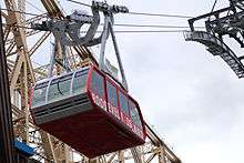
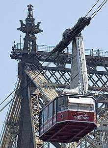
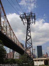
The Roosevelt Island Tramway contains two cabins that each run back and forth, suspended from their own pair of cables. Each cabin has a capacity of up to 125 people and makes approximately 115 trips per day. The tram moves at about 16 mph (26 km/h) and travels 3,100 feet (940 m) in 3 minutes. At its peak it climbs to 250 feet (76 m) above the East River as it follows its route on the north side of the Ed Koch Queensboro Bridge, providing views of the East Side of Midtown Manhattan. The tram runs every seven and half minutes from 6:00 a.m. to 2:00 a.m. (3:30 a.m. on weekends) and runs continuously during rush hours. [25]
The Roosevelt Island Tramway was the only aerial commuter tram in the US from 1976 until 2006, when the Portland Aerial Tram opened.[25]
Accessibility and transfers
The tram is wheelchair accessible. Bicycles are permitted on the tram.
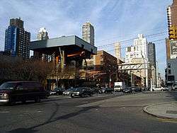
In Manhattan, the entrance to the system is at Tram Plaza at 60th Street and Second Avenue, with transfers to the M15, M15 SBS, M31, M57, Q32, Q60, Q101.[26] The closest New York City Subway station is the complex at Lexington Avenue/59th Street, served by the 4, 5, 6, <6>, N, R, and W trains. Lexington Avenue–53rd Street, served by the E and M trains, and Lexington Avenue–63rd Street on the F, N, Q, and R trains are also nearby.[27]
On Roosevelt Island, the "Red Bus" route meets the tram and offers transportation around the island for free.[28] During the tramway reconstruction, the Red Bus was extended to Queens Plaza and the Manhattan side of the Queensboro Bridge.[29] The publicly operated Q102 bus also provides transportation on the island.[30] The Roosevelt Island subway station, serving the F train, is located north of the tramway entrance.[31]
See also
References
- 1 2 3 Ferretti, Fred (May 18, 1976). "Aerial Tram Ride to Roosevelt Island Is Opened With a Splash on O'Dwyer". The New York Times. p. 69. Retrieved February 20, 2010.
- ↑ "Queensboro Bridge Opens to Traffic" (PDF). The New York Times. March 31, 1909. Retrieved February 20, 2010.
- ↑ Phillips, McCandlish (April 7, 1957). "City's Last Trolley at End of Line; Buses Will Replace 49-Year Route on Queensboro Span" (PDF). The New York Times. p. 1. Retrieved August 17, 2008.
- ↑ "Welfare Island Gets Own Bridge; $6,500,000 Link With Long Island City Is Opened by Jack and Lundy" (PDF). The New York Times. May 19, 1955. Retrieved 2009-08-15.
- ↑ "Close Bridge Footpath" (PDF). The Leader-Observer. Woodhaven, New York. July 25, 1974. p. 3. Retrieved 2017-10-19 – via Fultonhistory.com.
- ↑ Clalrborne, William (July 10, 1975). "Roosevelt Island, New York City's Other Island; a $400 Million Futuristic New Town In the Middle of East River" (PDF). The Washington Post. Woodhaven, New York: Watertown Daily Times. p. 4. Retrieved 2017-10-19 – via Fultonhistory.com.
- ↑ Johnston, Laurie (November 14, 1978). "Roosevelt Island's Tram Is Shut Down for Repairs". The New York Times. ISSN 0362-4331. Retrieved June 12, 2017.
- ↑ "Senate Votes Down Bill For Insuring Tramway". The New York Times. February 26, 1986. ISSN 0362-4331. Retrieved June 12, 2017.
- ↑ "FOR ROOSEVELT ISLAND, DETOURS ON FIRST DAY WITHOUT TRAM". The New York Times. February 16, 1986. ISSN 0362-4331. Retrieved June 12, 2017.
- ↑ Howe, Marvine (December 26, 1993). "NEIGHBORHOOD REPORT: ROOSEVELT ISLAND; When Will Troubled Tram Reopen? Give It a Few More Weeks". The New York Times. ISSN 0362-4331. Retrieved July 26, 2016.
- ↑ ".: Roosevelt Island Operating Corporation of the State of New York :". ny.gov.
- ↑ "The 2005 Transit Strike: Transportation Impacts and Analysis" (PDF). New York City Department of Transportation. February 2006. p. 30. Retrieved 2017-10-19.
- ↑ AP News, April 18, 2006, 10:44 p.m. (ET)
- ↑ Barron, James (April 20, 2006). "Options Were Limited After a Power Surge". The New York Times. Retrieved February 20, 2010.
- ↑ AP News, September 1, 2006, 6:52AM (ET)
- ↑ Blaustein, Michael; Namako, Tom (February 26, 2010). "Hangin' on for a tramway revamp: Roosevelt ride closing for rehab". New York Post. Retrieved March 2, 2010.
- ↑ Traina, Meredith (February 28, 2010). "Roosevelt Island Tram Suspended For Major Modernization". WPIX. Archived from the original on July 24, 2011. Retrieved March 2, 2010.
- 1 2 Clark, Roger (March 1, 2010). "Roosevelt Island Tram Shuts Down For Renovation". NY1. Archived from the original on January 30, 2013. Retrieved March 2, 2010.
- ↑ Kilgannon, Corey (February 28, 2010). "Open & Shut: Chronicle of a Changing City". The New York Times. Retrieved March 2, 2010.
- ↑ Clark, Roger (November 30, 2010). "Roosevelt Island Tram Once Again Running Over The East River". NY1. Archived from the original on December 3, 2010. Retrieved November 30, 2010.
- ↑ Grynbaum, Michael M. (2010-11-30). "Roosevelt Island Tramway Reopens After Renovations". The New York Times. Retrieved 2017-10-31.
- ↑ Spitz, Rebecca (September 24, 2010). "Roosevelt Island Tram Renovation Nearly Complete". NY1. Archived from the original on September 29, 2010. Retrieved September 25, 2010.
- ↑ "Second Roosevelt Island Tram Cabin Attached To Cables". NY1. October 22, 2010. Archived from the original on July 14, 2011. Retrieved October 23, 2010.
- ↑ Spitz, Rebecca (November 23, 2010). "Roosevelt Island Tram Gets Wired Up; Undergoes Test Run". NY1. Archived from the original on November 25, 2010. Retrieved November 23, 2010.
- 1 2 Cohen, Billie (January 15, 2008). "Roosevelt Island Tram". The New York Times. Retrieved August 17, 2008.
- ↑ "Manhattan Bus Map" (PDF). Metropolitan Transportation Authority. December 2017. Retrieved April 24, 2018.
- ↑ "MTA Neighborhood Maps: Midtown East / Grand Central" (PDF). mta.info. Metropolitan Transportation Authority. 2018. Retrieved October 1, 2018. }
- ↑ ".: Roosevelt Island Operating Corporation of the State of New York :". ny.gov.
- ↑ "Roosevelt Island Operating Corporation Queens/Manhattan Red Shuttle Bus Service Schedule" (PDF). Roosevelt Island Operating Corporation. Retrieved March 2, 2010.
- ↑ "Queens Bus Map" (PDF). Metropolitan Transportation Authority. December 2017. Retrieved April 24, 2018.
- ↑ "MTA Neighborhood Maps: Long Island City" (PDF). mta.info. Metropolitan Transportation Authority. 2018. Retrieved October 1, 2018.
External links
| Wikimedia Commons has media related to: |
- Official website
- Manhattan entrance (Second Avenue and 60th Street) on Google Maps Street View
- Manhattan station inside from Google Maps Street View
- Roosevelt Island entrance from Google Maps Street View
- Car interior from Google Maps Street View
- Pictorials
- "Roosevelt Island Tram". nycsubway.org.
- Berne, Laurent (November 12, 2010). "TPH 110 V Roosevelt Island Tramway" (in French). Remontees Mecaniques (Ski Lifts).
Technical data and pictures about the new ropeway
- "Soaring High Above New York City on an Aerial Tramway". Greg Goodman. July 29, 2011.
Photo essay
- "Fotografías del teléferico de Roosevelt Island" [Pictures of the Roosevelt Island tramway] (in Spanish). Guia Turistica de Nueva York.
- "Tram". Kogeto. Archived from the original on April 7, 2014.
Panoramic video of tram ride
Coordinates: 40°45′27″N 73°57′20″W / 40.75750°N 73.95556°W
Crossings of the East River | ||||
|---|---|---|---|---|
| ||||