City of Bunbury

| City of Bunbury Western Australia | |||||||||||||||
|---|---|---|---|---|---|---|---|---|---|---|---|---|---|---|---|
 Location in Western Australia | |||||||||||||||
| Population | 31,919 (2016 census)[1] | ||||||||||||||
| • Density | 485.8/km2 (1,258.3/sq mi) | ||||||||||||||
| Established | 1871 | ||||||||||||||
| Area | 65.7 km2 (25.4 sq mi) | ||||||||||||||
| Mayor | Gary Brennan | ||||||||||||||
| Council seat | Bunbury | ||||||||||||||
| Region | South West | ||||||||||||||
| State electorate(s) | Bunbury | ||||||||||||||
| Federal Division(s) | Forrest | ||||||||||||||
|
| |||||||||||||||
| Website | City of Bunbury | ||||||||||||||
| |||||||||||||||
The City of Bunbury is a local government area in the South West region of Western Australia, covering an area of 65.7 square kilometres (25.4 sq mi) along the coast about 180 kilometres (112 mi) south of Perth, the capital of Western Australia. The City of Bunbury is one of four local governments comprising the Greater Bunbury sub-region. As at the 2016 Census, the City of Bunbury had an estimated population of almost 32,000.
History
In 1871, the Municipality of Bunbury was gazetted, and in 1899 the Bunbury Suburban Road District (which became the Bunbury Road District in 1908) followed. The two entities merged in 1950.
On 1 July 1961, the Municipality of Bunbury became a town following the enactment of the Local Government Act 1960. In 1979 it attained city status.[2]
Wards
The town has 12 councillors and no wards. Each councillor serves a four-year term, and half-elections are held every two years. The mayor is directly elected.
Twin towns and sister cities
The City of Bunbury has a sister / friendship city relationship with:
In 2009, Bunbury-Jiaxing Business Office was established to boost business opportunities between the two regions by assisting with communications and facilitating trade.[4]
Suburbs
- Bunbury
- Carey Park
- College Grove
- Davenport
- East Bunbury
- Glen Iris
- Pelican Point
- Picton
- South Bunbury
- Usher
- Vittoria
- Withers
Population
| Year | Population |
|---|---|
| 1971 | 17,779 |
| 1976 | 19,513 |
| 1981 | 21,749 |
| 1986 | 23,031 |
| 1991 | 25,657 |
| 1996 | 26,490 |
| 2001 | 28,564 |
| 2006 | 29,336 |
| 2011 | 31,348 |
| 2016 | 31,919 |
Gallery
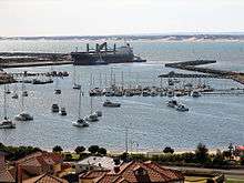 View west of the harbour from the lookout tower, August 2007
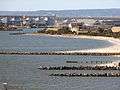 View north of the harbour from the lookout tower, August 2007
 Wheat silos converted to residential apartments
References
- ↑ Australian Bureau of Statistics (27 June 2017). "Bunbury (C)". 2016 Census QuickStats. Retrieved 26 November 2017.

- ↑ WA Electoral Commission, Municipality Boundary Amendments Register (release 2.0), 31 May 2003.
- ↑ "International Relationships". City of Bunbury. Retrieved 12 April 2016.
- ↑ Verne, Ross (11 December 2013). "Bunbury-China ties celebrated". Bunbury Mail. Retrieved 12 April 2016.