Bukit Merah
| Bukit Merah | |
|---|---|
| Planning Area and HDB Town | |
| Other transcription(s) | |
| • Chinese | 红山 |
| • Pinyin | Hóng Shān |
| • POJ | âng-soaⁿ |
| • Malay | Bukit Merah |
| • Jawi | بوكيت ميره |
| • Tamil | புக்கிட் மேரா |
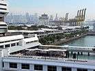 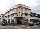 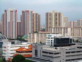 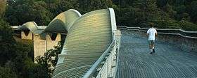  From top left to right: HarbourFront, Singapore Improvement Trust flats in Tiong Bahru, Skyline of Redhill, Henderson Waves, Jetty at Labrador Nature Reserve | |
 Bukit Merah Location of Bukit Merah within Singapore | |
| Coordinates: 1°16′54.86″N 103°49′26.11″E / 1.2819056°N 103.8239194°E | |
| Country |
|
| Region |
|
| CDCs | |
| Town councils |
|
| Constituencies | |
| Government | |
| • Mayors |
Central Singapore CDC South West CDC |
| • Members of Parliament |
Jalan Besar GRC Radin Mas SMC Tanjong Pagar GRC
West Coast GRC |
| Area[1][2] | |
| • Total | 14.34 km2 (5.54 sq mi) |
| • Residential | 3.12 km2 (1.20 sq mi) |
| Population (2017)[1][2][3] | |
| • Total | 152,790 |
| • Density | 11,000/km2 (28,000/sq mi) |
| Demonym(s) |
Official
Colloquial
|
| Ethnic groups[4] | |
| • Chinese | 122,610 |
| • Malays | 13,400 |
| • Indians | 15,120 |
| • Others | 4,710 |
| Postal districts | 2, 3, 4, 5, 9, 10 |
| Dwelling units | 51,885 |
| Projected ultimate | 68,000 |
Bukit Merah (Chinese: 红山, Tamil: புக்கிட் மேரா), also abbreviated as either Bt Merah or BM, is a planning area and new town situated in the southernmost part of the Central Region of Singapore. The planning area borders Tanglin to the north, Queenstown to the west and the Downtown Core, Outram and Singapore River planning areas of the Central Area to the east. Bukit Merah also shares a maritime boundary with the Southern Islands planning area located beyond its southernmost point. Bukit Merah is the most populated planning area in the Central Region, and the 10th most populated planning area in the country overall, being home to more than 150,000 residents.[5]
Etymology
Bukit Merah (Jawi: بوكيت ميره) translates to "Red Hill" in Malay, and is a reference to the red-coloured lateritic soil found on the hill. According to the Sejarah Melayu, Singapore used to be plagued by swordfish attacking the people living in the coastal regions. A young boy named Hang Nadim proposed an ingenious solution, to build a wall of banana stems along the coast at the present location of Tanjong Pagar. When the swordfish attacked, their snouts were stuck in the stems. With the swordfish problem solved, Hang Nadim earned great respect from the people, but also jealousy from the rulers. The King, Paduka Seri Maharaja, finally ordered his execution, and it was said that his blood soaked the soil of the hill where he was killed, giving rise to the red-coloured hill.[6]
The hill was eventually trimmed to its current state in 1973, when it made way for Redhill Close and what would eventually become Henderson Secondary School. During its existence, a Chinese cemetery was situated on the reverse side of this hill, which is today, the location of Tiong Bahru.
History
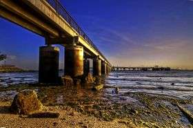
Keppel Harbour dates back to the 14th century when an ancient Chinese traveller, Wang Dayuan named the harbour as "Long-Ya-Men" or "Dragon Teeth Gate" after two rock outcrops located near Labrador Park, which resembled dragon's teeth. The two rock outcrops were subsequently blown up by the Straits Settlements Surveyor, John Thomson, in August 1848 to widen the entrance a new harbour.
Mount Faber was once known as Telok Blangah Hill. Its name was changed to Mount Faber after Captain Edward Faber cut the road up to the top in 1845 to set up a signal station. The Singapore General Hospital site dates back to 1882. Labrador Nature Park was used as a defence outpost in the 19th century until World War II.[7]
With the earliest records of Bukit Merah's existence in the Malay Annals, the town had a huge role to play in the early maritime trade of the Kingdom of Singapura.
The town's fertile red soil was employed to great effect, when it was a district rich in gambier cultivation during British colonial rule.[8]
Even before the industrialisation of Jurong, Bukit Merah already had a small head start in the emerging heavy industry market in Singapore. With the first brickwork factories and mills emerging in the precincts of Henderson Hill and Redhill as early as the 1930s.[9]
The town is also home to the first housing estate in the country, Tiong Bahru, which was developed by the Singapore Improvement Trust in the backdrop of a rapidly growing population in post-war Singapore. The estate later became the basis of what would eventually become the first new town in the Republic, Queenstown.
Geography
According to the various master plans laid out by the Urban Redevelopment Authority, Bukit Merah is bounded by Alexandra Canal and the Singapore River to the north and Harbourfront and Keppel Bay to the south, Kim Seng Road, Outram Road and Cantonment Road to the east and Alexandra Road to the west. There are several subzones within the planning area, namely Alexandra, Bukit Ho Swee, Bukit Merah Central, Depot Road, Everton Park, HarbourFront, Henderson, Redhill, Singapore General Hospital, Telok Blangah and Tiong Bahru.
Subzones
| Name of estates | Location | Notable structures | Accessibility |
|---|---|---|---|
| Alexandra | Areas along Alexandra Road, Jalan Bukit Merah, Jalan Rumah Tinggi and Hoy Fatt Road | Alexandra Hospital, Alexandra Central, Alexandra Retail Centre, Alexandra Village, AIA Building, IKEA Alexandra, and Brickworks and Rumah Tinggi HDB Estates | Labrador Park MRT Station, Redhill MRT Station and buses |
| Bukit Ho Swee | Areas along Jalan Bukit Ho Swee and Delta | PSB Academy, Kim Seng Community Centre and shophouses along Havelock Road | Tiong Bahru MRT Station, Havelock MRT Station (future) and buses |
| Bukit Merah Central | Areas along Bukit Merah Central | Bukit Merah Town Centre, Bukit Merah Bus Interchange, Bukit Merah Polyclinic, Bukit Merah Public Library, Bukit Merah Secondary School, Gan Eng Seng Primary School | Buses |
| Depot Road | Areas along Depot Road | Central Manpower Base, Depot Heights Shopping Centre, ISS International School, The Interlace | Buses |
| Everton Park | Areas bounded by Cantonment Road, Neil Road, Keppel Road | Cantonment Primary School, Former Tanjong Pagar railway station, Police Cantonment Complex | Cantonment MRT Station (future), Buses |
| HarbourFront | Bukit Merah South | HarbourFront Bus Interchange, HarbourFront Cruise Centre, Singapore Cruise Centre, St. James Power Station, VivoCity | HarbourFront MRT Station, Buses, Cable Car, Sentosa Express |
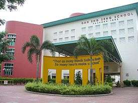
| Henderson | Bukit Merah West | Alexandra Primary School, Bukit Merah West NPC, Gan Eng Seng School, Henderson Community Club | Buses |
| Redhill | Northwestern Bukit Merah | Alexandra Canal, Delta Sports Complex, Leng Kee Community Centre, Enabling Village and Redhill MRT Station | Redhill MRT Station, Buses |
| Singapore General Hospital | Bukit Merah East | Duke-NUS Graduate Medical School, Health Promotion Board, New Bridge Road Bus Terminal, Outram Polyclinic, Singapore General Hospital | Outram Park MRT Station, Buses |
| Telok Blangah | Bukit Merah South | Blangah Rise Primary School, CHIJ St. Theresa's Convent, Mount Faber Park, Radin Mas Community Club, Radin Mas Primary School, SAFRA Mount Faber, Telok Blangah Community Club, Telok Blangah Hill Park | Telok Blangah MRT Station, Buses |
| Tiong Bahru | Areas along Tiong Bahru Road | Tiong Bahru Community Centre, Tiong Bahru Market, Tiong Bahru MRT Station, Tiong Bahru Park, Tiong Bahru Plaza, Zhangde Primary School | Tiong Bahru MRT Station, Buses |
Transportation
Mass Rapid Transit
There are currently 5 MRT stations that serve the planning area across 3 lines, the East West Line, Circle Line and North East Line. HarbourFront MRT station is an interchange station between the North East Line and the Circle Line, which is also the current terminus for both lines. The 5 stations are :
- EW17 Tiong Bahru
- EW18 Redhill
- CC27 Labrador Park
- CC28 Telok Blangah
- NE1 CC29 HarbourFront
Future stations that are currently under construction include:
- TE16 Havelock
- CC30 Keppel
- CC31 Cantonment
Havelock MRT Station of the Thomson-East Coast Line, that will be operational in 2021, is situated near to the Bukit Ho Swee estate, making Bukit Merah the planning area that has the second-most number of MRT lines passing through it, following the Central Area. The future stations, Keppel and Cantonment will be located within the new town as part of the Stage 6 of the Circle Line that will be completed by 2025.[10]
Bus
There are two bus interchanges and one bus terminal in the new town. The Bukit Merah Bus Interchange (红山巴士转换站), which serves Bukit Merah, is located at Bukit Merah Town Centre. Service Number 132 links the Interchange to Redhill MRT Station while bus services 5, 16, and 851 links the interchange to Tiong Bahru MRT Station. There are two feeder services originating from the interchange which serves the Telok Blangah estate. The HarbourFront Bus Interchange is located at the southern part of Bukit Merah, serving nearby amenities such as the HarbourFront Centre and VivoCity, the largest shopping mall in Singapore. The Kampong Bahru Bus Terminal is located along Spooner Road, near the vicinity of the Singapore General Hospital
Education
Bukit Merah consists of several Primary and Secondary schools with Alexandra Primary School being the newest school.
Primary Schools
- Alexandra Primary School
- Blangah Rise Primary School
- Cantonment Primary School
- CHIJ Kellock
- Gan Eng Seng Primary School
- Radin Mas Primary School
- Zhangde Primary School
Secondary Schools
Tertiary Institutions
Other Schools
- APSN Tanglin School
- ISS International School (Preston Campus)
- Shelton College International
Amenities
Places of Worship
Buddhist Temples
Churches
- Grace Assembly of God 1
- Church of God Singapore
- Church of St. Teresa
- Danish Seamen's Church
- Grace Methodist Church
- Pasir Panjang Tamil Methodist Church
- St. Matthew's Church
- Telok Ayer Chinese Methodist Church
Chinese Temples
- Ban Siew Temple
- Geck Hong Tian Temple
- Hock Teck Tong Temple
- Koon Seng Ting Temple
- Lei Yin Temple
- Ling San Teng Temple
- Qui Tian Gong Temple
- San Jiang Gong Ci Temple
- Tai Yeong Temple
- Tian Gong Miao Temple
- Tian Tan Temple
Hindu Temples
Mosques
- Masjid Al-Amin Mosque
- Masjid Jamiyah Ar-Rabitah Mosque
- Masjid Kampong Delta Mosque
- Masjid Temenggong Daeng Ibrahim
Sikh Temples
- Gurdwara Sahib Silat Road
Shopping Centres
- Alexandra Central
- Alexandra Retail Centre
- Concorde Shopping Centre
- Depot Heights Shopping Centre
- HarbourFront Centre
- Tiong Bahru Plaza
- VivoCity
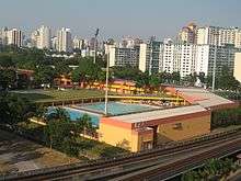
.jpg)
Parks
- Alexandra Canal Linear Park
- Alexandra Hill East Neighbourhood Park
- Bukit Purmei Hillock Park
- Henderson Park
- Labrador Nature Reserve
- Mount Faber Park
- Rumah Tinggi Eco Park
- Telok Blangah Hill Park
- Tiong Bahru Park
Community Centres/Clubs
- Bukit Merah Community Centre
- Henderson Community Club
- Kim Seng Community Centre
- Leng Kee Community Centre
- Radin Mas Community Club
- Telok Blangah Community Club
- Tiong Bahru Community Centre
Sports facilities
- Delta Sports Complex
- SAFRA Mount Faber
- Sports Lifestyle Centre
Politics
Bukit Merah belongs to five political divisions in four constituencies. A large portion of Bukit Merah is under Tanjong Pagar GRC, with some areas under Jalan Besar GRC , Radin Mas SMC and West Coast GRC, served by the People's Action Party. Indranee Rajah is the current Member of Parliament for the Tanjong Pagar-Tiong Bahru division, while Joan Pereira is the current Member of Parliament for the Henderson-Dawson division of the Tanjong Pagar GRC since 2015. Sam Tan is the current Member of Parliament for Radin Mas SMC since 2011 while Lim Hng Kiang is the Member of Parliament for the Telok Blangah division of West Coast GRC. Lily Neo is the current Member of Parliament for the Kreta Ayer-Kim Seng division of the Jalan Besar GRC.
See also
| Wikimedia Commons has media related to Bukit Merah. |
References
- 1 2 City Population – statistics, maps and charts | Bukit Merah
- 1 2 HDB Key Statistics FY 2014/2015 Archived 4 March 2016 at the Wayback Machine.
- ↑ "Land Area and Dwelling Units by Town". Data Singapore. 2016. Retrieved January 26, 2018.
- ↑ "Singapore Residents by Planning Area/Subzone, 2015" (XLS). Singapore Department of Statistics.
- ↑ "Statistics Singapore – Geographic Distribution". singstat.gov.sg. Retrieved 6 June 2017.
- ↑ "Bukit Merah Town Centre". lostnfiledsg. Retrieved 9 November 2015.
- ↑ "Singapore Bukit Merah Map & Bukit Merah Singapore". streetdirectory.com. Retrieved 9 November 2015.
- ↑ "Singapore Infopedia – Bukit Merah". National Library Board.
- ↑ "ALEXANDRA BRICKWORKS". The Straits Times. 17 February 1931.
- ↑ "Three new stations to close loop on Circle Line". TODAYonline. Retrieved 13 March 2016.
Sources
- Victor R Savage, Brenda S A Yeoh (2003), Toponymics – A Study of Singapore Street Names, Eastern Universities Press, ISBN 981-210-205-1
- https://lostnfiledsg.wordpress.com/2012/08/09/bukit-merah-town-centre/
- http://eresources.nlb.gov.sg/infopedia/articles/SIP_779_2005-01-26.html
External links
- Legend of Bukit Merah at the Singapore Museum website
- Redhill – Culturally Rich. 30 October 2013, Website: http://alexresidencescondo-sg.com/news-updates/redhill-culturally-rich/