Pasir Ris
| Pasir Ris | |
|---|---|
| Planning Area and HDB Town | |
| Other transcription(s) | |
| • Chinese | 巴西立 / 白沙 |
| • Pinyin | Bāxīlì / Báishā |
| • Malay | Pasir Ris |
| • Jawi | ڤاسير ريس |
| • Tamil | பாசிர் ரிஸ் |
   | |
 Pasir Ris Location of Pasir Ris within Singapore | |
| Coordinates: 1°22′19.54″N 103°56′50.54″E / 1.3720944°N 103.9473722°E | |
| Country |
|
| Region |
|
| CDC | |
| Town council |
|
| Constituency | |
| Government | |
| • Mayor |
North East CDC |
| • Members of Parliament |
Pasir Ris-Punggol GRC |
| Area[1][2] | |
| • Total | 15.02 km2 (5.80 sq mi) |
| • Residential | 3.18 km2 (1.23 sq mi) |
| Population (2015)[1][2] | |
| • Total | 139,890 |
| • Density | 9,300/km2 (24,000/sq mi) |
| Demonym(s) |
Official
Colloquial
|
| Postal districts | 17, 18 |
| Dwelling units | 29,207 |
| Projected ultimate | 44,000 |
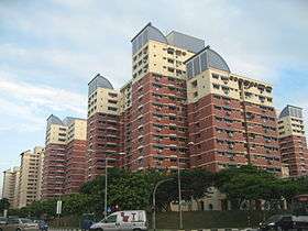
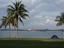
Pasir Ris (Chinese: 巴西立 or 白沙, Tamil: பாசி ரிஸ்) is a planning area and residential town located in the East Region of Singapore. It is bordered by Tampines and Paya Lebar to the south, Sengkang to the southwest and Changi to the east. The planning area also shares riverine boundary with Punggol to the west, separated by the Serangoon River, as well as having a maritime boundary with the North-Eastern Islands planning area, across the Straits of Johor.[3]
Like other new towns, public transport facilities were factored into the development of Pasir Ris. Pasir Ris is easily accessible via bus services at Pasir Ris Bus Interchange and the Mass Rapid Transit at Pasir Ris MRT Station. Today, landmarks in the area include the NTUC Pasir Ris Resort, Pasir Ris Beach Park and White Sands shopping mall.
Etymology
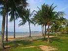
The first reference to a village of Pasir Ris, Passier Reis (or Passier Rice), appeared in early 1800s. The second part of the city name, Ris, in Malay, means bolt rope.[4] Pasir Ris may also mean "white sand" in Malay.[5] Pasir Ris Town is named after the long stretch of sandy white beach along the north-east coastline of Singapore, facing Pulau Ubin. The town exudes a resort ambience and its architecture and identity take inspiration from the surrounding beach and sea elements.[6]
History
Pasir Ris was originally a high key-lying, undeveloped area with kampongs and villages like Kampong Pasir Ris, Kampong Bahru and the various Chinese kampongs along Elias Road. The area was well known for its many plantation estates including the Singapore United Plantations, Loh Lam Estate, Hun Yeang and Thai Min Estates. The beach was a popular resort for water skiing in the 1950s. There was also the Pasir Ris Hotel, venue of many memorable parties and picnic gatherings in the 1950s, 1960s and early 1970s.[7]
The development of Pasir Ris Town began in 1983 with Phase 1 being an Elias Road/Pasir Ris Estate, followed by Loyang N1 and N2 by 1989–90, N4 from 1992 to 1993, N5 from 1995 and N6 in 1997 together with N7. The proposed Neighbourhood 3 (N3) is just an empty land and (N8) is part of military training area, will be reviewed in 2018. Today, White Sands Shopping Centre, located next to Pasir Ris MRT Station, embodies the local place name.
Geography

Loyang Industrial Estate encompasses of three subzones, Loyang West, Loyang East and Flora Drive. The Town of Pasir Ris contains within it, four subzones, Pasir Ris Central, Pasir Ris West, Pasir Ris Drive and Pasir Ris Park. Although Pasir Ris Wafer Fabrication Park is not a part of the Loyang Industrial Estate, it still functions as its own individual subzone nonetheless. In total, the entire planning area has eight subzones.[3]
Pasir Ris has some hills less than 40 metres in height. Since 2014, these hills have been flattened to make way for upcoming residential development.
Political boundaries
Pasir Ris comes politically under the Pasir Ris-Punggol Group Representation Constituency since 2001 and Pasir Ris Group Representation Constituency from 1997 to 2001. After the general election in 2001, a large part of the former Pasir Ris Central Division and the Pasir Ris-Loyang Division came together as Pasir Ris East with Zainal Sapari as the Member of Parliament since 2011.
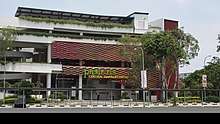
Pasir Ris West consists of Elias housing estate and the western area of Pasir Ris and its Member of Parliament being Deputy Prime Minister and Co-ordinating Minister for National Security Teo Chee Hean. In conjunction with the expansion of Pasir Ris-Punggol Group Representation Constituency (GRC), a Community Club scaling six storeys high, was built in Pasir Ris East. In October 2004, Pasir Ris West also saw the completion of Pasir Ris Elias Community Club.
Amenities
Recreation

In proximity to the sea, Pasir Ris has several recreation areas like the NTUC Downtown East, which have facilities like chalets, theme parks, a bowling alley, a park for pets and pet owners and Pasir Ris Park. There is also another park by the name of Pasir Ris Town Park, close to where the Shopping Centre White Sands is located. The park sports a park connector, a playground, an eatery and fishing pond and a section of the park has been removed to build the Sports and Recreation Centre with facilities such as swimming pool, a sports hall to be used mainly for badminton, a street soccer court and also a gym. The bowling alley building in Downtown East has been demolished to make way for a new four-storey shopping and entertainment complex with a cinema which has been completed in 2008 called E!hub. E!hub also includes a new bowling alley, which replaces the old one. The area also includes a water-based theme park and a now defunct theme park. They are Escape Theme Park, which opened in 2000 but was closed down in 2011, and Wild Wild Wet, which is a water-based theme park that opened in 2004. The current site of the former Escape Theme Park will be utilized for expansion of Wild Wild Wet.
Industry
Pasir Ris is also part of the Jurong Town Corporation's plan to develop wafer fabrication facilities in Singapore. The other two locations are Tampines and Woodlands. Presently, there are two major wafer fabrication parks in Pasir Ris. Companies situated there include United Microelectronics Corporation and SSMC. Pasir Ris have two recycling factory in the N2 area.
Education
As of 2017, this area has a total of 7 primary schools, 4 secondary schools and Meridian Junior College.[8] Two secondary schools, Greenview Secondary School and Siglap Secondary School were closed down as a result of rationalisation exercise since March 2016. There is one international school, Overseas Family School.
Places of worship
As of 2017, this area has one Buddhist temple, one Catholic church, one Mosque and four churches.
Commercial services
As of 2017, this area has six shopping malls, Loyang Point, Pasir Ris Drive 6, White Sands Shopping Centre, Elias Mall, Pasir Ris West Plaza and NTUC Downtown East. There are two community clubs, Pasir Ris East and Pasir Ris Elias (Pasir Ris West).Pasir Ris Central Hawker Center - which is opened in January 2018 has 42 stalls and the homeground of traditional street food and hipster kitchens.
References
- 1 2 City Population - statistics, maps and charts | Pasir Ris
- 1 2 HDB Key Statistics FY 2014/2015 Archived 4 March 2016 at the Wayback Machine.
- 1 2 "Population Trends 2017" (PDF). Ministry of Trade and Industry. ISSN 1793-2424.
- ↑ Ng Yew Peng (2018). Tay Yu Shan, ed. What's In The Name? How The Streets And Villages In Singapore Got Their Names. World Scientific. ISBN 978-981-32-2139-0. OCLC 990571127.
- ↑ Pasir Ris Retrieved 2018-07-09.
- ↑ "Pasir Ris". Retrieved 2018-07-09.
- ↑ "Pasir Ris | Infopedia". Eresources.nlb.gov.sg. Retrieved 2015-11-09.
- ↑ School Information Service