Raffles Place
| Raffles Place | |
|---|---|
| Name transcription(s) | |
| • Chinese | 莱佛士坊 |
| • Pinyin | Láifóshì Fāng |
| • Malay | Pesara Raffles |
| • Tamil | ராஃபிள்ஸ் பிளேஸ் |
 | |
| Country | Singapore |
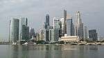
Raffles Place is the centre of the Financial District of Singapore and is located south of the mouth of the Singapore River.[1] It was first planned and developed in the 1820s as Commercial Square to serve as the hub of the commercial zone of Singapore in Raffles Town Plan. It was renamed Raffles Place in 1858 and is now the site of a number of major banks. It is located in the Downtown Core within the Central Area, and features some of the tallest buildings and landmarks of the country.
History
Beginning
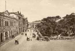
The founder of modern Singapore, Sir Stamford Raffles, intended Singapore to become a "great commercial emporium". As part of his plan, he gave instructions in 1822 that a commercial area be created on the southwest side of the Singapore River.[2] The Garrison Engineer Lieutenant R.N. Philip Jackson, was tasked with drawing up a Town Plan based on Raffles' instructions. This commercial area was centered on Commercial Square, and was developed from 1823 to 1824.
A hill originally stood at the area between Commercial Square and Battery Road.[3] Under Raffles' supervision, the hill was leveled, the soil of which was then used to reclaim the marshy southern bank of the Singapore River to form the Boat Quay and Circular Road area. Commercial Square was created as an open space 200 yards long by 50 yards wide, with a small garden in the middle.[4] Lots of land in the area around the square were sold in auction at $1,200 and $1,500 apiece.[4] Commercial enterprises then became established on the area; two- and four-storey buildings were built around the square, housing mercantile offices, banks and trading companies.[5]
On 8 March 1858, Commercial Square was renamed Raffles Place in Raffles' honour.[3] On the south side of the square were many godowns with jetties that allowed cargo to be loaded and unloaded directly from boats as they were then located at the edge of the sea. From 1858 to 1864, the land on the south side of Raffles Place from Johnston's Pier to Telok Ayer Market was reclaimed, which became Collyer Quay, named after the Chief Engineer George Collyer who initiated its construction.[6] The expansion freed up a larger area designated for commerce, and attracted more businesses such as retail stores and banks.[5]
Commerce and retail
The area become the location for well-known retail stores in the 19th century. A retail store that would become Singapore's oldest department store John Little was established on 30 August 1842 on Commercial Square.[7] Robinsons, another of the early department stores, was first established on Raffles Place in 1858 as a "family warehouse". Robinson's was then relocated elsewhere a few times before returning back to Raffles Place in 1891.[8] Whiteaway Laidlaw was first established on D'Almeida Street in 1900 before moving to Stamford House, then to Battery Road in 1910.[9] The Alkaff Arcade, Singapore's first indoor shopping arcade that stretched from the waterfront of Collyer Quay to Raffles Place, was built in 1909.[10] A Chinese store, the Oriental Emporium, was opened opposite Robinsons in 1966.[11]
The earliest banks to operate in Commercial Square were the Oriental Bank, the Chartered Mercantile Bank of India, London and China (later absorbed into HSBC), the Chartered Bank of India, Australia and China (which later became the Standard Chartered), and the Asiatic Banking Corporation.[3] At the turn of the 20th century, the banking industry in Singapore took off. Home-grown banks came into play, competing against bigger banks with lower interest rates and a cultural affinity with their customers. From the 1950s, banking in Singapore entered a new league, with Bank of America establishing itself here in 1955 at 31 Raffles Place, and Bank of China at the adjacent Battery Road.[5]
During World War II, Raffles Place was among the places hit by bombs when seventeen Japanese bombers conducted the first air raid on Singapore on 8 December, 1941, during the Battle of Malaya.[12] The Japanese occupation of Singapore temporarily halted the near-continuous commercial development of Raffles Place.[5]
Financial hub
In the 1960s and 1970s, retailers began to moved away from Raffles Place area to locations such as High Street, North Bridge Road and Orchard Road, and were replaced by finance houses and major banks. The Whiteaway Laidlaw department store building on Battery Road was taken over by Malayan Bank in 1962, and then demolished to make way for the Maybank Tower in 1998.[13] Robinsons moved to Orchard Road after its landmark building was destroyed in one of the worst fires in Singapore's history in 1972, and its neighbour Overseas Union Bank expanded into the site with the construction of a new tower in 1986.[8][3] The John Little's Building was sold in 1973 and demolished.[7]

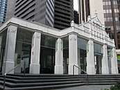
The first underground car park in Singapore was constructed in 1965 under Raffles Place, but was replaced in the 1980s by the Raffles Place MRT Station, which opened in December 1987.[14][15] Its entrance features detailings of the facade of 1911 of the old John Little building.[3]
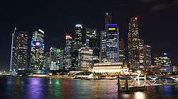
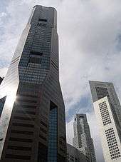
Raffles Place is now dominated by Skyscrapers, some of the tallest buildings in Singapore, which are the locations of flagship banks. United Overseas Bank tower was completed in 1974 on the old Bonham Building site, later renovated and expanded into UOB Plaza. Other towers such as Singapore Land Tower, Clifford Centre, Ocean Building, OUB Centre, and Republic Plaza have also replaced the older buildings.[5] The three tallest buildings in Singapore were located on Raffles Place the until the construction of Tanjong Pagar Centre in 2016.[16]
Notable buildings
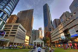
Several key buildings are located in Raffles Place, including UOB Plaza, One Raffles Place, Republic Plaza, and OCBC Centre. The Fullerton Hotel Singapore, a hotel at the renovated old General Post Office building, the famous tourist icon the Merlion, and an ultra modern durian shaped Art Centre Esplanade Theatre are located nearby. The stock exchange of Singapore - the Singapore Exchange - is also located in the vicinity. Several key administrative buildings in Singapore, such as the Parliament House, the Supreme Court and City Hall are located north across the river, but are technically not part of Raffles Place.
Transportation
The underground Mass Rapid Transit station, the Raffles Place MRT Station, lies directly underneath the centre of Raffles Place, and is one of the primary public transport links for Raffles Place into Singapore's transport system. Bus services also run along Raffles Place.
References
- ↑ "The Financial District". Rough Guide.
- ↑ Charles Burton Buckley (1902). An anecdotal history of old times in Singapore. pp. 81–86.
- 1 2 3 4 5 Cornelius, Vernon. "Raffles Place". Singapore Infopedia. National Library Board.
- 1 2 Charles Burton Buckley (1902). An anecdotal history of old times in Singapore. pp. 88–89.
- 1 2 3 4 5 Singapore's 100 Historic Places. National Heritage Board. Archipelago Press. 2002. pp. 44–45. ISBN 981-4068-23-3.
- ↑ Cornelius, Vernon. "Collyer Quay". Singapore Infopedia. National Library Board.
- 1 2 Leow, Annabeth (7 November 2016). "John Little to close final outlet at Plaza Singapura: 174 years of history at a glance". The Straits Times.
- 1 2 "Robinsons Department Store". Singapore Infopedia. National Library Board.
- ↑ Joshua Chia Yeong Jia. "Whiteaway Laidlaw". Singapore Infopedia. National Library Board.
- ↑ Marsita Omar. "The (Alkaff) Arcade". Singapore Infopedia. National Library Board.
- ↑ "The Emporium Legend Lim Tow Yong (1925-2012)". Remember Singapore. 9 April 2012.
- ↑ Chua, Alvin. "First air raid on Singapore". Singapore Infopedia. National Library Board.
- ↑ Joshua Chia Yeong Jia. "Whiteaway Laidlaw". Singapore Infopedia. National Library Board.
- ↑ "Raffles Place, 50 Years of Transformation". Remember Singapore. 28 July 2014.
- ↑ "A Journey into Singapore MRT's Past". Remember Singapore. 23 July 2013.
- ↑ Melissa Tan (May 3, 2013). "Tanjong Pagar Centre set to be tallest building at 290m". The Straits Times.
External links
| Wikimedia Commons has media related to Raffles Place. |
Coordinates: 1°17′02″N 103°51′05″E / 1.28389°N 103.85139°E