Hougang
| Hougang | |
|---|---|
| Planning Area and HDB Town | |
| Other transcription(s) | |
| • Chinese | 后港 |
| • Pinyin | Hòu Găng |
| • Malay | Hougang |
| • Tamil | ஹவ்காங் |
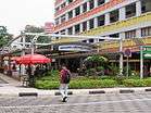 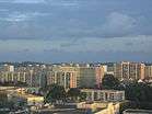 _-_Typical_Village_Kampung_house_(9721908363).jpg) 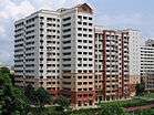 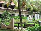 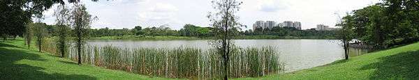 From top left to right: Hougang Central, Aerial view of Kovan, Kampong Lorong Buangkok, Flats along Hougang Avenue 4, Heritage Garden of the Institute of Mental Health, Panoramic view of Punggol Park | |
 Hougang Location of Hougang within Singapore | |
| Coordinates: 1°22′18.4″N 103°53′35″E / 1.371778°N 103.89306°E | |
| Country |
|
| Region |
|
| CDCs | |
| Town councils |
|
| Constituencies | |
| Government | |
| • Mayors |
Central Singapore CDC North East CDC South East CDC |
| • Members of Parliament |
Aljunied GRC Ang Mo Kio GRC Hougang SMC Marine Parade GRC |
| Area[1][2] | |
| • Total | 13.93 km2 (5.38 sq mi) |
| • Residential | 3.67 km2 (1.42 sq mi) |
| Population (2017)[1][3] | |
| • Total | 224,390 |
| • Density | 16,000/km2 (42,000/sq mi) |
| Demonym(s) |
Official
Colloquial
|
| Postal district | 19 |
| Dwelling units | 51,646 |
| Projected ultimate | 72,000 |
Hougang (Chinese: 后港, Tamil: ஹவ்காங்) is a planning area and residential town located in the North-East Region of Singapore. The town is the most populous in the region, being home to 222,310 residents.[4] Hougang planning area is bordered by Sengkang to the north, Geylang to the south, Bedok to the southeast, Toa Payoh to the southwest, Paya Lebar to the east and Serangoon to the west.
Etymology and history
Hougang is the pinyin version of Aū-káng, a Hokkien and Teochew name meaning "river end", as Hougang is located upstream or at the back of Sungei Serangoon. In the past, the name connoted the area stretching from the fifth milestone junction of Upper Serangoon Road and Upper Paya Lebar Road/Boundary Road to the seventh and a half milestone junction of Upper Serangoon Road and Punggol Road. The area just beyond the seventh milestone along Punggol Road was formerly considered part of Punggol but is now within Hougang Town and that section of Punggol Road is now Hougang Avenue 8, with Punggol Road starting further north.[5]
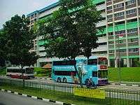
Pig farming was carried out in Punggol, including the area of Punggol that is now part of Hougang Town. The last of these pig farmers were relocated by the late-1990s to flats built in Hougang. Today, Hougang is an HDB new town with over 40,000 housing units interspersed with pockets of private residential areas.
There was also a fishing port at the end of Upper Serangoon Road beyond the seventh milestone.
At Hougang Street 21, there was a well that is still identified as the tua jia kha (大井脚) well structure. This well identified the Teochew village of tua jia kha which means the "foot of a big well". In the past, the village was a popular place for food, street wayangs, itinerant Chinese medicine men and story tellers spinning yarns.
Hougang has been developed since 1977 with the construction of Tampines Way. Further development has been made for the development of new neighbourhoods in Neighbourhood 1 - 3 by 1983, Neighbourhood 4 - 7 by 1992. Neighbourhood 8 is the city centre of the Hougang, completed in 1994. Neighbourhood 9 has been in the recent and has been completed by 2000.
In 2015, project named Hougang Capeview, a Build-To-Order project at Upper Serangoon Road, is the first public housing project to receive the CONQUAS Star, an accolade administered by the Building and Construction Authority. Hougang Capeview, which comprises 781 residential units in six blocks at Upper Serangoon Road, received a Construction Quality Assessment System (CONQUAS) score of more than 95, above the national average of 88.2. The CONQUAS score is BCA’s measure of construction quality across Singapore.[6]
Amenities


Hougang is regarded as part of the "heartland" of Singapore, a significant distance away from the Central Area. Most of its commercial activity is centred on a few shopping malls such as Hougang Mall, Kang Kar Mall, Heartland Mall, Upper Serangoon Shopping Centre and Hougang1.
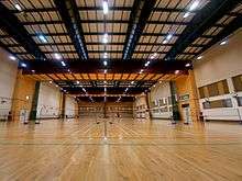
Similar to most other residential towns in Singapore, Hougang was designed to be a partially self-sufficient with enough amenities to minimize the number of residents commuting to the Central Area. Facilities include Hougang Sports Hall, an indoor sports complex operated by Sport Singapore which runs ClubFITT membership and sports programmes, Hougang stadium home to S.League club Hougang United, an aquatics centre, a number of parks such as Punggol Park, along with many wet markets and hawker centres.
One of the more prominent landmarks in Hougang is the Buangkok Green Medical Park, which houses several medical facilities including the Institute of Mental Health (IMH) and Singapore Leprosy Relief Association (SILRA). Hougang is served by two MRT stations: Hougang MRT Station which is located beside the bus interchange and Hougang Mall; and Kovan MRT Station which is beside Heartland Mall. Residents in Buangkok bordering Sengkang have the option of using Buangkok MRT Station as well.
The Hougang Central Bus Interchange serves Hougang Town with a range of bus services going to other parts of the island. It is located in Hougang Central, near Hougang Mall and it has an underground link to Hougang MRT Station. This bus interchange was officially opened on 17 February 1995 by former cabinet minister Goh Chee Wee, who was then Senior Minister of State for Communications, Trade and Industry to serve all buses around the Hougang Area. Its sister bus interchange, Hougang South Bus Interchange (that is near to Kovan MRT station) ceased operations in 2004 and was converted to Kovan Hub.
Two even older bus terminals operated in Hougang before the construction of the Hougang Central and Hougang South Bus Interchanges. One was at the end of Upper Serangoon Road in Kangkar Village, which was replaced by Hougang Central, while the other was at the sixth and a half milestone of Upper Serangoon Road, which was replaced by Hougang South.[7]
Highlights
A distinctive feature of Hougang lies in the large semi-circular balconies which occur in many Housing and Development Board public housing flats in the area. This feature is not as prevalent in public housing outside Hougang.
Politics
The political representation of Hougang was split into four different constituencies as of the 2015 elections, three of which were Group Representation Constituencies (GRC) (Aljunied, Ang Mo Kio, and Marine Parade), and one Single Member Constituency (SMC) bearing the same name, the Hougang Single Member Constituency. Currently, Aljunied and Hougang wards were managed by the opposition Workers' Party (WP), while Ang Mo Kio and Marine Parade were managed by the ruling People's Action Party (PAP). Previously, Hougang were administered by five now-defunct wards (Jalan Kayu, Paya Lebar, Punggol, Serangoon Gardens and Upper Serangoon), before it redistricted into GRCs, notably Cheng San GRC (also defunct since 2001).
The area covering Hougang Avenues 2, 5, 7 and a small portion of Hougang Central, were under the namesake Hougang SMC, where it was carved out from Punggol ward ahead of the 1988 elections. The first Member Of Parliament (MP) of the ward was PAP's Tang Guan Seng, until it had been captured by former WP secretary-general Low Thia Khiang, in 1991. Low left the ward to contest (and later elect himself in) Aljunied GRC ahead of the 2011 elections, and was replaced by Yaw Shin Leong, a candidate whose part of the WP team contested Ang Mo Kio GRC in the 2006 elections.[8] Yaw remained as an MP until his expulsion from the party's CDC and his resignation of the seat in February 2012 over an extramarital affair. Png Eng Huat, a candidate whose part of the WP team contested East Coast GRC in the 2011 elections, had since represented this ward after winning his by-election on May 2012.
The area covering south of Hougang Avenues 6, 8, 10, as well as Punggol Park, Defu Industrial Park and Kovan, were under both Paya Lebar and Bedok Reservoir-Punggol divisions of Aljunied GRC. The GRC was previously managed by the PAP which members include Cynthia Phua and former Foreign Minister George Yeo, until it was taken over by WP's Chen Show Mao and Low Thia Khiang, respectively, in the 2011 elections, with the takeover marked the first time an opposition party had been elected in a GRC since it was established in 1988. The GRC was not contested in 2001 with the WP being disqualified due to incomplete applications, but in the 2006 elections, the WP were able to pose a strong challenge for this ward, with the members consist of WP's chairwoman Sylvia Lim and former member James Gomez.[9]
The north-western portions of Hougang (Avenues 4, 8 and 9, and Street 91), which included Hougang Stadium and Regentville Condo, were under the Ang Mo Kio-Hougang division of Ang Mo Kio GRC. Its MP is Darryl David, who replaces former MP Yeo Guat Kwang after the 2015 elections. Prior to the 2011 elections, the ward was a part of Aljunied GRC (under the name of Aljunied-Hougang), where Yeo was then the MP.
The northern portions of Hougang (north of Avenues 6, 8 and Street 51) were under the Sengkang South division, also part of the Ang Mo Kio GRC, where Gan Thiam Poh was the MP. It was previously belong to Pasir Ris-Punggol GRC (under the name of Punggol South) until it was carved out in 2015.
The western portions of Hougang, previously being Serangoon Gardens division, belonged to the Jalan Kayu (Ang Mo Kio) and Serangoon (Aljunied) divisions, which were represented by Intan Azura Mokhtar and Sylvia Lim, respectively. The area was previously belong to the short-lived Thomson GRC in 1991.
The southernmost portion of Hougang, Tai Seng, was under the Geylang Serai division of the Marine Parade GRC, where Fatimah Lateef represented the ward. Marine Parade was also contested by WP during the 2015 elections.
Schools
The area has a total of eight secondary schools, nine primary schools and Serangoon Junior College.[10] Serangoon Junior College is closing in 2019 and merging with Anderson Junior College.[11]
| Wikimedia Commons has media related to Singapore#Hougang. |
References
- 1 2 "Bukit Merah (Planning Area, Singapore) - Population Statistics, Charts, Map and Location". www.citypopulation.de.
- ↑ HDB Key Statistics FY 2014/2015 Archived 4 March 2016 at the Wayback Machine.
- ↑ "Land Area and Dwelling Units by Town". Data Singapore. 2016. Retrieved January 26, 2018.
- ↑ "Hougang (Planning Area, Singapore) - Population Statistics and Location in Maps and Charts". City Population (with data from Singapore Department of Statistics). Retrieved August 15, 2016.
- ↑ "OneMap, see Historical Maps from 1970s or earlier".
- ↑ http://www.channelnewsasia.com/news/singapore/hougang-bto-development/2134928.html
- ↑ List of former bus stations in Singapore
- ↑ "E: WP takes Hougang, PAP wins 11 SMCs". Channel NewsAsia. Retrieved June 8, 2012.
- ↑ Aljunied Group Representation Constituency
- ↑ "School Information Service (SIS)". sis.moe.gov.sg.
- ↑ "Anderson, Serangoon JCs among 8 junior colleges to merge". Channel NewsAsia. Retrieved 2017-11-21.
Sources
- Victor R Savage, Brenda S A Yeoh (2003), Toponymics - A Study of Singapore Street Names, Eastern Universities Press, ISBN 981-210-205-1