Tuas
| Tuas | |
|---|---|
| Planning Area | |
| Other transcription(s) | |
| • Chinese | 大士 |
| • Pinyin | Dà shì |
| • Malay | Tuas |
| • Jawi | تواس |
| • Tamil | துவாஸ் |
 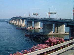 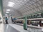 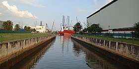 From top to bottom: Johor Straits Lighthouse at Raffles Marina, Malaysia–Singapore Second Link, Tuas Link MRT station, ships near Tuas South Avenue 5 | |
 | |
 Tuas Location of Tuas within Singapore | |
| Coordinates: 1°19′00″N 103°39′00″E / 1.31667°N 103.65000°E | |
| Country |
|
| Region |
|
| CDC | |
| Town council |
|
| Constituency | |
| Government | |
| • Mayor |
South West CDC |
| • Members of Parliament |
West Coast GRC |
| Area[1] | |
| • Total | 30.0 km2 (11.6 sq mi) |
| Area rank | 6th |
| Population (2017)[1] | |
| • Total | 70 |
| • Rank | 44th |
| • Density | 2.3/km2 (6.0/sq mi) |
| • Density rank | 46th |
| Demonym(s) |
Official
|
| Postal district | 22 |
Tuas is a planning area located within the West Region of Singapore. It is bounded by the Western Water Catchment to its north, Pioneer to its east and the Straits of Johor to its west. Tuas also shares a maritime boundary with the Western Islands planning area to its east.
The Malaysia–Singapore Second Link that links Singapore to Malaysia is located in Tuas.
Etymology
Tuas is derived from a daytime fishing method uncommon these days. The coastal Malays floated coconut fronds and leafy branches kept close together by the rising tide. A large net was then spread and suspended below. The shade provided drew in the fish. More and more were attracted until, at a given signal, the net was hauled up by the Malay fishermen in the boats. Levering or hauling up is menuas, which became tuas. Tuas also means "to chop in two pieces", "to raise by leverage", and "to support".
History
The Tuas area in the early nineteenth century was referred to by three place names: Tg Kampong, Tg Rawa and Tg Gull — references made in Franklin and Jackson's 1830 map of Singapore.
Tuas used to be swampland which was later cleared for squatter settlement. By the mid twentieth century, it became a fishing village. In the old days, it was not unusual to see about 200 fishing boats in Tuas every morning.
In the 1970s, the residents in Tuas were resettled to public housing estates. Tuas was then developed for industrial use. In the 1980s, land was reclaimed off Tuas for more industrial development. By 1988, about 6.5 km² of land off Tuas were reclaimed. Land reclamation off Tuas is still ongoing; the land area of Tuas increased from 17.02 km² in 1996 to 30.04 km² presently. Penta-Ocean Construction was the main construction firm involved in the land reclamation[2]. The peninsular formed from the late 1980s to early 1990s is known as Tuas South, while the land currently being reclaimed to the southeast of Tuas Jetty is known as the Tuas View Extension.
Industry
Being far away from the main residential areas and the commercial district of Singapore, Tuas was chosen as a site for industrial development as the adjacent industrial areas in Jurong Industrial Estate were being built. Heavy industries can be found in Tuas, although not as much as on Jurong Island. Two of Singapore's four incinerators are also found in Tuas, namely Tuas Incinerator and Tuas South Incinerator. A world-scale renewable diesel plant, using palm oil as feedstock, which was completed in 2010, is also located in the area. Its capacity will make it the largest plant of its kind (800,000 tons per annum).
Further reclamation as part of the Tuas South extension is being done to house the world's largest storage of oil.
Tuas mega port will be completed by 2040 to house all of PSA current assets and operations, PSA will give up its city terminals by 2027 and Pasir Panjang Terminal by 2040.[3] Tanjong Pagar terminal had ceased operations in October 2017 marking the beginning of the end of an era of port operation in the area which dates back to the modern founding of Singapore in 1819.[4]
Residential areas
Tuas has a number of residential buildings provided at low cost for the people who work there. Some are located at Benoi Sector, which also has an eating place, whilst the others are located at Pioneer Road.
The low rise flats are normally named from Blocks A to H, and are usually 9 to 11 stories high. They are built to meet basic residential requirements; they provide shelter with an electricity and water supply.
Accessibility
On 18 June 2017, 4 MRT stations opened on the East West Line as part of the Tuas West Extension to serve the area. They are:
- EW30 Gul Circle
- EW31 Tuas Crescent
- EW32 Tuas West Road
- EW33 Tuas Link[5]
References
- 1 2 Tuas (Planning Area, Singapore) - Population Statistics, Charts, Map and Location
- ↑ Humphreys, Neil (2012). Return to a Sexy Island: Notes from a New Singapore. Marshall Cavendish International Asia. p. 182. ISBN 978 9814398 855.
- ↑ https://www.channelnewsasia.com/news/cnainsider/singapore-needs-tuas-mega-port-maritime-trade-automated-9934474
- ↑ http://www.straitstimes.com/singapore/world-record-set-at-tanjong-pagar-terminal-to-mark-end-of-an-era-of-port-operations-there
- ↑ Tuas West Extension opens on 18 June 2017
- Victor R Savage, Brenda S A Yeoh (2003), Toponymics - A Study of Singapore Street Names, Eastern Universities Press, ISBN 981 210 205 1
Neighbouring areas | |
|---|---|