Crawford, Singapore
| Crawford | |
|---|---|
| Subzone of Kallang Planning Area | |
| Other transcription(s) | |
| • Chinese | 哥罗福 |
| • Malay | Crawford |
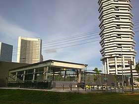 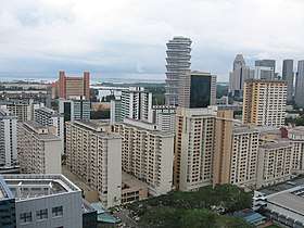 Top: Exit of Nicoll Highway MRT station along Republic Avenue Bottom: Housing and Development Board (HDB) flats at Crawford Lane | |
| Country |
|
| Region | Central Region |
| Planning Area | Kallang |
Crawford (Chinese: 哥罗福) is a subzone within the planning area of Kallang, Singapore, as defined by the Urban Redevelopment Authority (URA). Its perimeter is made up of Rochor River and Rochor Canal in the north; Crawford Street, Nicoll Highway, Kallang Basin and Marina Channel in the east; East Coast Parkway (ECP) in the south; as well as Ophir Road, Beach Road and Jalan Sultan in the west.[1]
As Crawford is located directly adjacent to the Downtown Core, many commercial developments have since sprung up in this area. Landmarks include The Concourse, The Plaza, Golden Mile Complex, St John Headquarters, Masjid Hajjah Fatimah, Kallang Riverside Park and Marina Promenade.
Several blocks of public housing constructed by the Housing and Development Board (HDB) are found along North Bridge Road and Beach Road, where the Kampong Glam Community Club and Kampong Glam Neighbourhood Police Post are situated.
Nicoll Highway MRT station provides Mass Rapid Transit (MRT) access to this subzone.
References
External links
![]()
| Organisations |  | |
|---|---|---|
| Building Programmes |
| |
| Upgrading Programmes |
| |
| Other | ||