Booroorban
| Booroorban New South Wales | |
|---|---|
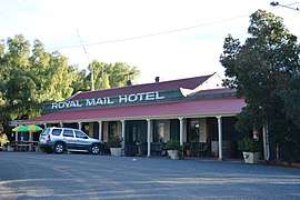 Royal Mail Hotel | |
|
Booroorban | |
| Coordinates | 34°56′S 144°46′E / 34.933°S 144.767°ECoordinates: 34°56′S 144°46′E / 34.933°S 144.767°E |
| Population | 33 (2016 census)[1] |
| Location |
|
| LGA(s) | Edward River Council |
| County | Townsend |
| State electorate(s) | Murray |
| Federal Division(s) | Farrer |
Booroorban is a locality in the central part of the Riverina. It is in the Edward River Council local government area and on the Cobb Highway between Hay and Deniliquin, around 769 kilometres (478 mi) south west of the state capital, Sydney. At the 2016 census, Booroorban had a population of 33.[1]
The community sits alongside the Booroorban State Forest. Facilities include a pub—the Royal Mail Hotel—and a public hall.
Booroorban Post Office opened on 16 September 1881 and closed in 1986.[3]
References
- 1 2 Australian Bureau of Statistics (27 June 2017). "Booroorban". 2016 Census QuickStats. Retrieved 4 August 2017.

- ↑ Travelmate Archived March 25, 2007, at the Wayback Machine.
- ↑ Premier Postal History, Post Office List, retrieved 2009-06-11
External links
![]()
This article is issued from
Wikipedia.
The text is licensed under Creative Commons - Attribution - Sharealike.
Additional terms may apply for the media files.