Bocas del Toro District
| Bocas del Toro District | |
|---|---|
| District | |
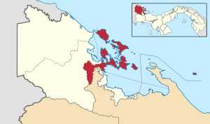 | |
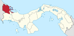
 Bocas del Toro District Location of the district capital in Panama | |
| Coordinates: 9°20′N 82°15′W / 9.333°N 82.250°WCoordinates: 9°20′N 82°15′W / 9.333°N 82.250°W | |
| Country |
|
| Province | Bocas del Toro |
| Capital | Bocas Town |
| Area | |
| • Total | 167.3 sq mi (433.2 km2) |
| Population (2012) | |
| • Total | 16,185 |
| Time zone | UTC-5 (ETZ) |
Bocas del Toro District is a district (distrito) of Bocas del Toro Province in Panama. The population according to the 2012 census was 16,815.[1] The district covers a total area of 433.2 km². The capital lies at the city of Bocas del Toro.[1] Major industries include tourism and agriculture.
Administrative divisions
Bocas del Toro District is divided administratively into the following corregimientos:
Table of Islands
| Nr | Island | Capital | Other Cities | Area (km²) | Population[lower-alpha 1] |
|---|---|---|---|---|---|
| 1 | Cauchero Mainland area | Cauchero | Tierra Oscura, Hope well, Secretaria, shark Hole, | 185 | 3455 |
| 2 | Bocas del Toro Archipelago | Bocas Town | Bastimentos, Punta Laurel, Isla Popa | 248.2 | 12730 |
| 2.1 | Bastimentos Island | Bastimentos town | Red Frog, Quebrada de Sal, Bahia Honda, | 52 | 1663 |
| 2.2 | Carenero Island | Caranero Town | Playa Buccaneer, Brown Point, Playa Acuario, | 1 | 737 |
| 2.3 | Cayo Agua Island | Puebla Limon | P. Piedra Roja, P. de Tiburon, P. de Nispero, P. Norte, Playa Resorte Agua | 16 | 529 |
| 2.4 | Cayo Coral | Cayo Coral | 0.05 | 4 | |
| 2.5 | Cayo Mono | Cayo Mono | 0.11 | 18 | |
| 2.6 | Cayos Zapatilla | Cayo Sur Station | Cayo Norte, Cobler Point, | 0.48 | 2 |
| 2.7 | Colon Island | Bocas Town | Big Creek, Boca Del Drago | 61 | 6629 |
| 2.8 | Cristobal Island | Botabite | Bocatorito, Big Bight, Redmans, Valle escondido, | 37 | 1329 |
| 2.9 | German Soldier cay | German Soldier cay | 0.2 | 1 | |
| 2.10 | Isla de Bagui | Bagui Town | 0.38 | 56 | |
| 2.11 | Isla Loma | Loma Partida | Punta Sumwood | 3.56 | 225 |
| 2.12 | Isla Pastores | Pastores Town | Playa starfish, Punta Fors, Punta Vergayo, Punta Maya | 2.45 | 50 |
| 2.13 | Jack Analy Cays | Jack Analy sur | Jack Analy norte | 0.06 | 1 |
| 2.14 | Popa Island | Popa Town | Punta Laurel, Punta Tigre | 53 | 1201 |
| 2.15 | Solarte Island | Solarte Town | Punta Hospital, Tucker Bight, Punta Juan Brown, | 8 | 285 |
| 2.16 | Other Islands | Cayo Rodlan | 12 | 0 | |
| Bocas del Toro District | Bocas Town | Bastimentos, Cauchero, Punta Laurel, Tierra Oscura, | 433.2 | 16185 |
Climate
Bocas del Toro is a coastal location with a tropical climate. The area does not have a predictable dry season. The driest times are late August to mid-October, February, and March.[2] Bocas del Toro is humid. Thundershowers and heavy rain are common. Normal temperatures are consistent all year (Hi: 83-90, low: 71-75). Due to its low latitude, sunrise is around 6 AM, and sunset is around 6 PM local time. These times vary slightly during the year. Weather data is collected at Bocas del Toro "Isla Colón" International Airport:
| Climate data for Bocas del Toro (1971-2000) | |||||||||||||
|---|---|---|---|---|---|---|---|---|---|---|---|---|---|
| Month | Jan | Feb | Mar | Apr | May | Jun | Jul | Aug | Sep | Oct | Nov | Dec | Year |
| Average high °C (°F) | 30.8 (87.4) |
30.7 (87.3) |
31.0 (87.8) |
31.4 (88.5) |
31.9 (89.4) |
32.0 (89.6) |
31.5 (88.7) |
31.8 (89.2) |
31.9 (89.4) |
31.7 (89.1) |
31.6 (88.9) |
31.0 (87.8) |
31.4 (88.6) |
| Average low °C (°F) | 20.4 (68.7) |
20.2 (68.4) |
20.5 (68.9) |
21.4 (70.5) |
22.2 (72) |
22.2 (72) |
21.7 (71.1) |
21.8 (71.2) |
22.0 (71.6) |
22.0 (71.6) |
21.8 (71.2) |
20.6 (69.1) |
21.4 (70.5) |
| Average precipitation mm (inches) | 123.9 (4.878) |
266.1 (10.476) |
83.8 (3.299) |
369.1 (14.531) |
178.3 (7.02) |
259 (10.2) |
420.1 (16.539) |
440.7 (17.35) |
311.2 (12.252) |
150.5 (5.925) |
291.7 (11.484) |
563.6 (22.189) |
3,458 (136.143) |
| Average precipitation days | 16.6 | 14.6 | 14.8 | 15.2 | 16.7 | 17.9 | 20.9 | 18.4 | 15.8 | 16.4 | 17 | 20.0 | 204.3 |
| Source: World Meteorological Organization [3] | |||||||||||||
Transportation
The district consists of the Bocas del Toro Archipelago and a coastal mainland area. Ferries, water taxis, and private boats provide transportation to many locations. Buses connect boat docks and mainland commununities to adjacent districts and the rest of Panama. Bocas del Toro "Isla Colón" International Airport provides passenger and cargo flights to Panama and Costa Rica. Roads are usually dirt or gravel. Larger highways may be paved.
Infrastructure
Bocas del Toro is a rural district. Schools and medical clinics operate around the district. Sanitation is limited. Water filtration and treatment facilities are non-existent in most communities. Sewage treatment is non-existent. The government is working on building more infrastructure in rural areas.
See also
Notes
- ↑ The Islands area and population data retrieved from the 2012 census
References
- 1 2 "Districts of Panama". Statoids. Retrieved April 10, 2009.
- ↑ Frommer's Panama (2E, 2009), ISBN 978-0-470-37183-1.
- ↑ "World Weather Information Service - Bocas del Toro". World Meteorological Organization. Retrieved 25 July 2010.
Capital: Bocas del Toro | ||
| Almirante District |
|  |
| Bocas del Toro District | ||
| Changuinola District |
| |
| Chiriquí Grande District | ||
| Bocas del Toro Province | |
|---|---|
| Chiriquí Province | |
| Coclé Province | |
| Colón Province | |
| Darién Province | |
| Herrera Province | |
| Los Santos Province | |
| Panamá Province | |
| Veraguas Province | |
| West Panamá Province | |
| Sovereign states |  | |
|---|---|---|
Dependencies and other territories | ||