Montijo District
| Montijo District | |
|---|---|
| District | |
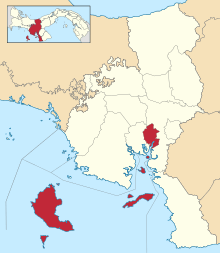 | |
 Montijo District Location of the district capital in Panama | |
| Coordinates: 7°59′32″N 81°3′16″W / 7.99222°N 81.05444°WCoordinates: 7°59′32″N 81°3′16″W / 7.99222°N 81.05444°W | |
| Country |
|
| Province | Veraguas Province |
| Capital | Montijo |
| Area | |
| • Total | 850 sq mi (2,202 km2) |
| Population (2000) | |
| • Total | 12,211 |
| Time zone | UTC-5 (ETZ) |
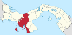
Map of the Montijo District in Panama
Montijo District is a district (distrito) of Veraguas Province in Panama. The population according to the 2000 census was 12,211.[1] The district covers a total area of 2,202 km². It includes all of the offshore islands of Coiba National Park, the largest of which are Coiba and Jicarón. The capital lies at the city of Montijo.[1] The district includes the Gulf of Montijo and the islands in it.
Administrative divisions
Montijo District is divided administratively into the following corregimientos:
References
- 1 2 "Districts of Panama". Statoids. Retrieved April 13, 2009.
External links
This article is issued from
Wikipedia.
The text is licensed under Creative Commons - Attribution - Sharealike.
Additional terms may apply for the media files.