Arraiján District
| Arraiján District | |
|---|---|
| District | |
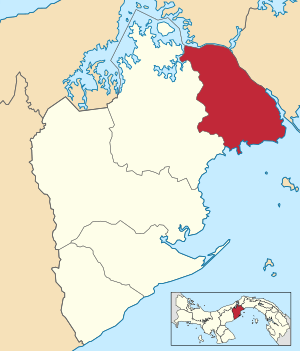 | |
 Arraiján District Location of the district capital in Panama | |
| Coordinates: 8°57′N 79°39′W / 8.950°N 79.650°WCoordinates: 8°57′N 79°39′W / 8.950°N 79.650°W | |
| Country |
|
| Province | West Panamá Province |
| Capital | Arraiján |
| Area | |
| • Total | 70 sq mi (170 km2) |
| Population (2000) | |
| • Total | 149,918 |
| Time zone | UTC-5 (ETZ) |
Arraiján District is a district (distrito) of West Panamá Province in Panama. The territory lies west of the Panama Canal bordering Panama City. The population according to the 2000 census was 149,918,[1] with a large number of suburban communities for commuting workers of Panama City. The district covers a total area of 170 km². The district seat is Arraiján city.[1]
Administrative divisions
Arraiján District is divided administratively into the following corregimientos:
Education
The Lycée français Paul Gauguin de Panama, a French international school, is in Panama Pacifico in Veracruz.[2]
References
- 1 2 "Districts of Panama". Statoids. Retrieved April 12, 2009.
- ↑ "Nuestra Ubicación Archived 2015-04-02 at the Wayback Machine."/"Où sommes nous? Archived 2015-04-02 at the Wayback Machine." Lycée français Paul Gauguin de Panama. Retrieved on 15 March 2015. "Dirección: Edificio 810, Ave. Ingeniero Way, Panamá Pacífico"
Capital: La Chorrera | ||
| Arraiján District | 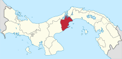 | |
| Capira District | ||
| Chame District | ||
| La Chorrera District | ||
| San Carlos District | ||
This article is issued from
Wikipedia.
The text is licensed under Creative Commons - Attribution - Sharealike.
Additional terms may apply for the media files.