Chiriquí Province
| Chiriquí Province Provincia de Chiriquí | |||
|---|---|---|---|
| Province | |||
 | |||
| |||
 | |||
| Coordinates (Seat of Government): 8°26′N 82°26′W / 8.433°N 82.433°WCoordinates: 8°26′N 82°26′W / 8.433°N 82.433°W | |||
| Country | Panama | ||
| Founded | May 26, 1849 | ||
| Capital | David | ||
| Area | |||
| • Total | 6,490.9 km2 (2,506.2 sq mi) | ||
| Highest elevation | 3,477 m (11,407 ft) | ||
| Lowest elevation | 0 m (0 ft) | ||
| Population (2010 census) | |||
| • Total | 416,873 | ||
| • Density | 64/km2 (170/sq mi) | ||
| Time zone | UTC-5 (EDT) | ||
| ISO 3166 code | PA-4 | ||
| Gini (2007) | 32.9 (low) | ||
| HDI (2007) |
| ||
| Website |
chiriqui | ||

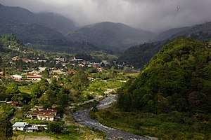
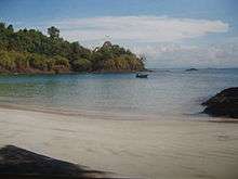
Chiriquí (Spanish pronunciation: [tʃiɾiˈki]) is a province of Panama located on the western coast; it is the second most-developed province in the country, after the Panamá Province. Its capital is the city of David. It has a total area of 6,490.9 km², with a population of 416,873 as of the year 2010.[1] The province of Chiriquí is bordered to the north by the provinces Bocas del Toro and Ngobe-Buglé, to the west by Costa Rica, to the east by the province of Veraguas, and to the south by the Pacific Ocean, specifically the Gulf of Chiriquí.
History
Until the arrival of the Spanish conquistadores, Chiriquí was populated by a number of indigenous tribes, known collectively as the Guaymí people.
The first European to visit and describe Chiriquí was Gaspar de Espinosa, in 1519. The province was officially established on May 26, 1849, when Panama was still part of Colombia. Several years later, President Abraham Lincoln of the United States proposed Chiriquí as a favored location for Linconia, a colony for free blacks from the United States; some 349 traveled here but most blacks were not interested in colonization elsewhere.
Chiriquí was the province in which Manuel Noriega rose in the military ranks in the late 20th century; he helped bring Omar Torrijos back into the country after a coup d'état. Noriega had jeeps lined up with their lights on the runway in David to allow Torrijos's aircraft to land. Chiriqui was at the heart of a short-lived pro-democracy guerrilla movement in the late 1960s and early 1970s. After the dictatorship by Manuel Noriega from 1983 to 1989, Guillermo Endara became president of Panama; he appointed Edgar De Puy as governor of Chiriquí.
Administrative divisions
Chiriquí Province is divided into 13 districts and 100 corregimientos.[2]
Note: - Through Law 55 of 13 September 2013, the creation del Tierras Altas District had been approved, consisting the following corregimientos of Cerro Punta, Cuesta de Piedra, Nueva California, Paso Ancho and Volcán; which they split off from Bugaba District and will have Volcán as its main centre. Also through that same law, the corregimiento of Solano was created, after splitting off from the corregimiento of La Concepción, Bugaba. However, that new administrative division within Chiriquí Province will come into effect by 2 May 2019.[3][4]
Climate
The province features a variety of climates, from hot and humid lowlands to the cool and moist highlands. The district is home to Fortuna Forest Reserve.
References
- ↑ Panama 2010 Census Retrieved: 24 May 2011
- ↑ "Municipios (distritos) de Chiriquí". Editorial OX. Retrieved 15 November 2012.
- ↑ «Presidente sanciona Ley que crea distrito de Tierras Altas en Chiriquí», Article from 16 September 2013 in the Ministry of Presidency of Panama website.
- ↑ Article from 16 September 2013 in the Gaceta Oficial Digital, n.º 27374.
External links
- Knowing more about Chiriqui in My Panama Live
- K. Holmberg 2010 'Placing Immateriality: Situating the Material of Highland Chiriquí', Internet Archaeology 28.
- The Art of Precolumbian Gold: The Jan Mitchell Collection, an exhibition catalog from The Metropolitan Museum of Art (fully available online as PDF), which contains material on Chiriqui
- , Temoltzin-Loranca, Y. et al., 2018, Late Holocene environmental change in Lake Boquete and its watershed: human or natural causes? Boletín de la Sociedad Geológica Mexicana. 70, 1: 121-131.
| Provinces | ||
|---|---|---|
Corregimiento-level Comarcas indígenas | ||