Coclé Province
| Coclé Province Provincia de Coclé | |||
|---|---|---|---|
| Province | |||
 | |||
| |||
|
Motto(s): "Trabajo, desarrollo y progreso" (Spanish) "Work, development and progress" | |||
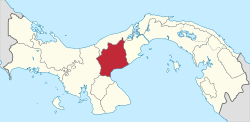 Location of Coclé in Panama | |||
| Coordinates (Seat of Government): 8°30′N 80°30′W / 8.500°N 80.500°WCoordinates: 8°30′N 80°30′W / 8.500°N 80.500°W | |||
| Country | Panama | ||
| Founded | 1985 | ||
| Capital | Penonomé | ||
| Area | |||
| • Total | 4,946.6 km2 (1,909.9 sq mi) | ||
| Population (2010 census) | |||
| • Total | 233,708 | ||
| • Density | 47/km2 (120/sq mi) | ||
| Time zone | UTC-5 (Eastern Time) | ||
| ISO 3166 code | PA-2 | ||

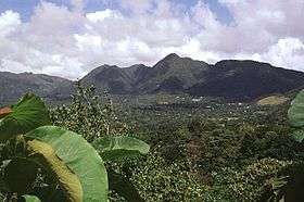
Coclé (Spanish pronunciation: [koˈkle]) is a province of central Panama on the nation's southern coast. The sub-capital is the city of Penonomé. This province was created by the Act of September 12, 1855 with the title of Department of Coclé during the presidency of Dr. Justo de Arosemena. It became a province, Decretory Number 190, on October 20, 1985. Coclé is primarily an agricultural area, with sugar and tomatoes as major crops. The province has a number of well-known beaches, such as Santa Clara, Farallon and Rio Hato, and tourist activity has increased in recent years. It has a population of 233,708 (2010).
Pre-Columbian Coclé
During pre-Columbian times, the area of Panama which today includes Coclé province had a number of identifiable native cultures. Archaeologists have loosely designated these cultures by pottery style. The poorly studied La Mula period ranged from 150 BC to AD 300. It was followed by the Tonosi period, from AD 300 to AD 550, and by the Cubita period, from AD 550 to AD 700. A unified Native American culture appears to have flourished in this area from approximately 1200 BC until the 16th century.
Administrative divisions
Coclé Province is divided into 6 districts and 44 corregimientos.[1]
| District | Cabecera (Seat) | |
|---|---|---|
| Aguadulce District | San Juan Bautista de Aguadulce, El Cristo, El Roble, Pocrí, Barrios Unidos | San Juan Bautista de Aguadulce |
| Antón District | Antón, Cabuya, El Chirú, El Retiro, El Valle, Juan Díaz, Río Hato, San Juan de Dios, Santa Rita, Caballero | Antón |
| La Pintada District | La Pintada, El Harino, El Potrero, Llano Grande, Piedras Gordas, Las Lomas, Llano Norte | La Pintada |
| Natá District | Natá de los Caballeros, Capellanía, El Caño, Guzmán, Las Huacas, Toza | Natá de los Caballeros |
| Olá District | Olá, El Copé, El Palmar, El Picacho, La Pava | Olá |
| Penonomé District | Penonomé, Cañaveral, Coclé, Chiguirí Arriba, El Coco, Pajonal, Río Grande, Río Indio, Toabré, Tulú, El Valle de San Miguel, Vista Hermosa, Los Uveros, El Silencio | Penonomé |
Research and conservation
Coclé is host to La MICA Biological Station where ongoing field research and conservation education is conducted. Parque Nacional General de División Omar Torrijos Herrera, established around the crash site of former Panamanian leader Omar Torrijos, is located in the northeastern portion of Coclé. Parque Omar, as it is known, enjoys some legal protection as a national park.
Coclé is also home to APROVACA orchid conservation center, which conducts orchid conservation activities, including orchid reintroduction into the wild and a sponsorship program for the Panamanian national flower Peristeria elata.
Folklorist Rosita Liao Gonzales was awarded the Order of Manuel José Hurtado for her work categorizing the cultures of Coclé Province.[2]
External links
- Coclé Archaeological Sites
- Sito Conte On-Line Collection, University of Pennsylvania Museum
- Pre-Columbian Gold artifacts from the Cocle Province
- Pre-Columbian Jade artifacts from the Cocle Province
- Pre-Columbian Stone artifacts from Cocle
- Pre-Columbian Pottery from Cocle
- Listing of Additional Archaeological Websites
References
- Lothrop, Samuel Kirland. Pre-Columbian Designs from Panama -Illustrations of Coclé Pottery. Dover Publications, Toronto, Canada, 1976. ISBN 0-486-23232-8.
- Specific
- ↑ "Municipios (Distritos) de Coclé". Editorial OX. Retrieved 15 November 2012.
- ↑ Tomado de: Liao González, Rosita. Las flores de la pollera: pequeño manual para confeccionar y ubicar los tembleques a la usanza coclesana / Rosita Liao González.--Panamá: Editora Sibauste,2003.--23p.
Capital: Penonomé | ||
| Aguadulce | | |
| Antón | ||
| La Pintada |
| |
| Natá | ||
| Olá | ||
| Penonomé |
| |
| Provinces | ||
|---|---|---|
Corregimiento-level Comarcas indígenas | ||