Bocas del Toro "Isla Colón" International Airport
| Bocas del Toro "Isla Colón" International Airport Aeropuerto Internacional de Bocas del Toro "Isla Colón" | |||||||||||
|---|---|---|---|---|---|---|---|---|---|---|---|
 | |||||||||||
| Summary | |||||||||||
| Airport type | Public | ||||||||||
| Operator | Autoridad Aeronáutica Civil | ||||||||||
| Serves | Bocas del Toro, Isla Colón, Panama | ||||||||||
| Elevation AMSL | 3 m / 10 ft | ||||||||||
| Coordinates | 09°20′27″N 082°15′03″W / 9.34083°N 82.25083°WCoordinates: 09°20′27″N 082°15′03″W / 9.34083°N 82.25083°W | ||||||||||
| Website |
bocasdeltorointernational | ||||||||||
| Map | |||||||||||
 MPBO Location in Panama | |||||||||||
| Runways | |||||||||||
| |||||||||||
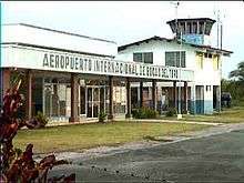
Bocas del Toro "Isla Colón" International Airport (Spanish: Aeropuerto Internacional de Bocas del Toro "Isla Colón") (IATA: BOC, ICAO: MPBO) is a public airport located 1.5 km (0.93 mi) northwest of the center of Bocas del Toro, a town on Isla Colón (Colón Island) in the Bocas del Toro Province of Panama.[1] The airport has a single runway with no taxiway. A small terminal exists at the east end of the runway.[4] International arrivals must clear Panamanian customs at the airport. Taxis and telephones are available.[1] No aviation fuel is available. The airport operates from 6:00 AM to 8:00 PM daily.[1]
The airport has a control tower (Bocas Tower 118.4) and runway lights.[1] The runway is aligned in an east-west direction and designated runway 08/26. The runway measures 1,500 m × 26 m (4,921 ft × 85 ft).[2] There is no apron or turn-around at the west end of the runway.[4] The airport can accommodate Biz Jets such as Bombardier Global Express, Gulfstreams, Dassault Falcon. The biggest scheduled plane is Air Panama Fokker 50
Airlines and Routes
| Airlines | Destinations |
|---|---|
| Air Panama[5] | Panama City-Albrook |
Weather
Bocas del Toro is a tropical coastal destination. The climate is hot and humid. Unlike most of Panama, Bocas does not have a clear wet and dry season. Thunderstorms occur year-round, which will delay flights. Bocas receives large amounts of precipitation.
| Climate data for Bocas del Toro, Panama | |||||||||||||
|---|---|---|---|---|---|---|---|---|---|---|---|---|---|
| Month | Jan | Feb | Mar | Apr | May | Jun | Jul | Aug | Sep | Oct | Nov | Dec | Year |
| Average high °F (°C) | 87 (31) |
89 (32) |
90 (32) |
89 (32) |
86 (30) |
85 (29) |
84 (29) |
84 (29) |
84 (29) |
83 (28) |
83 (28) |
84 (29) |
86 (30) |
| Average low °F (°C) | 71 (22) |
73 (23) |
74 (23) |
75 (24) |
74 (23) |
73 (23) |
73 (23) |
73 (23) |
73 (23) |
72 (22) |
72 (22) |
72 (22) |
73 (23) |
| Source: Weather Underground[6] | |||||||||||||
References
- 1 2 3 4 5 (in Spanish) Aeropuerto Internacional de Bocas del Toro "Isla Colón", Autoridad Aeronáutica Civil. (Retrieved: 24 May 2009)
- 1 2 Airport information for MPBO at World Aero Data. Data current as of October 2006.Source: DAFIF.
- ↑ Airport information for BOC at Great Circle Mapper. Source: DAFIF (effective October 2006).
- 1 2 Google Maps: 09°20'27"N, 082°15'03" W Retrieved: 24 May 2009.
- ↑ Air Panama Flights & Tickets Archived 9 March 2012 at the Wayback Machine. Retrieved: 24 May 2009.
- ↑ "Bocas del Toro". Weather Underground. Retrieved 29 May 2009.
External links
- BocasDelToro.com OFFICIAL WEBSITE - Everything about Bocas del Toro
- Current weather for MPBO at NOAA/NWS
- Accident history for BOC at Aviation Safety Network
- Weather Underground: Bocas del Toro