La Pintada District
| La Pintada District | |
|---|---|
| District | |
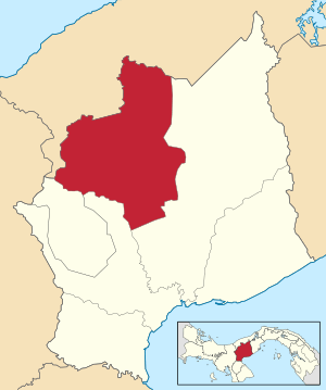 | |
 La Pintada District Location of the district capital in Panama | |
| Coordinates: 8°36′4″N 80°26′56″W / 8.60111°N 80.44889°W | |
| Country |
|
| Province | Coclé Province |
| Capital | La Pintada |
| Area | |
| • Total | 395 sq mi (1,024 km2) |
| Population (2000) | |
| • Total | 23,202 |
| Time zone | UTC-5 (ETZ) |
La Pintada District (Spanish pronunciation: [la pinˈtaða]) is a district (distrito) of Coclé Province in Panama. The population according to the 2000 census was 23,202.[1]The district covers a total area of 1024 km². The capital lies at the city of La Pintada.[1]
Administrative divisions
La Pintada District is divided administratively into the following corregimientos:
- La Pintada (capital)
- El Harino
- El Potrero
- Llano Grande
- Piedras Gordas
- Las Lomas
- Llano Norte
References
- 1 2 "Districts of Panama". Statoids. Retrieved April 10, 2009.
Capital: Penonomé | ||
| Aguadulce | 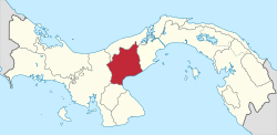 | |
| Antón | ||
| La Pintada |
| |
| Natá | ||
| Olá | ||
| Penonomé |
| |
This article is issued from
Wikipedia.
The text is licensed under Creative Commons - Attribution - Sharealike.
Additional terms may apply for the media files.