Geography of Saint Vincent and the Grenadines
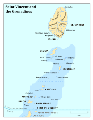
Saint Vincent and the Grenadines is an island state in the Windward Islands of the Lesser Antilles, an island arc of the Caribbean Sea in North America. The country consists of the main island of Saint Vincent and the northern two-thirds of the Grenadines, a chain of small islands stretching south from Saint Vincent to Grenada. Its total land area is 390 km² of which 342.7 km² is the main island of Saint Vincent. The country's capital is at Kingstown on Saint Vincent.
Table of Islands
The main island of Saint Vincent and the Grenadines is Saint Vincent. Its geography is mostly mountainous and includes very little level ground. There is also a large difference between the coastlines on each side of the island. The windward side is very rocky, while the leeward side consists of many sandy beaches and has many more bays. The island's as well as the country's highest peak is the volcanic Soufrière at 1234 m. There are several tiny islets offshore of Saint Vincent including Young Island and the Cow And Calves Islands.
the List of islands from North to South :
| Nr | Island [lower-alpha 1] | Capital | Other Cities | Area (km²) | Population |
|---|---|---|---|---|---|
| 1 | St. Vincent Group | Kingstown | Georgetown, Byera Village, Biabou, Chateaubelair, | 342.8 | 109010 |
| 1.1 | St. Vincent Island | Kingstown | Georgetown, Byera Village, Biabou, Chateaubelair, | 342.7 | 109000 |
| 1.2 | Young Island | Young Island dock | Ilha de Forte, South Point, Sunset Point | 0.07 | 10 |
| 1.3 | Other Islands | Cow And Calves Islands | 0.03 | 0 | |
| 2 | Grenadines (Northern) | Port Elizabeth | Dover, Derrick, Ashton, Bednoe, Charlestown, Cheltenham, Clifton, Friendship, Lovell, Old Wall, Paget Farm, Hamilton | 47.23 | 11000 |
| 2.1 | Bequia | Port Elizabeth | Hamilton, Belmont, Paget Farm, Derrick | 17.00 | 5900 |
| 2.2 | Petite Nevis | Eileen Corea mansion | 0.29 | 0 | |
| 2.3 | Quatre | Grand Bay | Mitchell mansion | 1.52 | 0 |
| 2.4 | Bettowia | Landing point | 0.71 | 0 | |
| 2.5 | Baliceaux | Landing Bay | 1.29 | 0 | |
| 2.6 | Mustique | Lovell | Britannia bay, Dover, | 5.70 | 800 |
| 2.7 | Petite Mustique | 0.40 | 0 | ||
| 2.8 | Savan | North Point | 0.11 | 0 | |
| 2.9 | Petite Canouan | 0.20 | 0 | ||
| 2.10 | Canouan | Charlestown | nen’s bay, Glossy, Taffia, Friendship, Barbruce, Riley bay, Carenage, Mysore bay, mahault bay, L’Ance guyac, cato bay, | 7.60 | 1200 |
| 2.11 | Mayreau | Old Wall | L’Ance bandeau, saltwhistle bay, saline bay, windward bay, | 2.10 | 280 |
| 2.12 | Tobago Cays | Petit Bateau, Petit Rameau, Baradol, Jamesby, Petit Tabac | 0.25 | 0 | |
| 2.13 | Union Island | Clifton | Ashton, | 9.00 | 2700 |
| 2.14 | Mopion | 0.002 | 0 | ||
| 2.15 | Petit Saint Vincent | telescope hill | west end beach, Caribbean beach, windy hill, windy harbor, Cross Point, Chevalier Point, atlantic beach, Conch Bay | 0.46 | 80 |
| 2.16 | Palm Island | Cactus Hill | Sunset grill beach, north beach, | 0.54 | 30 |
| 2.17 | Other Islands | Pigeon Island, Pillories Islands, Rabbit island, Dove cay, Catholic Island, Punaise | 0.06 | 0 | |
| Saint Vincent and the Grenadines | Kingstown | Georgetown, Byera Village, Biabou, P. Elizabeth, Chateaubelair, | 390 | 120000 |
The remainder of the Grenadines to the south are administered by Grenada.
Resources and land use
Natural resources: hydropower, cropland
Land use:
arable land:
10%
permanent crops:
18%
permanent pastures:
5%
forests and woodland:
36%
other:
31% (1993 est.)
Irrigated land: 10 km² (1993 est.)
Natural hazards: hurricanes; Soufrière on the island of Saint Vincent is a constant threat
Environment - current issues: pollution of coastal waters and shorelines from discharges by pleasure yachts and other effluents; in some areas, pollution is severe enough to make swimming prohibitive
Environment - international agreements:
party to:
Biodiversity, Climate Change, Desertification, Endangered Species, Environmental Modification, Hazardous Wastes, Law of the Sea, Ozone Layer Protection, Ship Pollution, Whaling
signed, but not ratified:
Climate Change-Kyoto Protocol
Geography - note: the administration of the islands of the Grenadines group is divided between Saint Vincent and the Grenadines and Grenada
See also
Notes
- ↑ The Islands area and population data retrieved from the 2012 census
External links
- http://www.CanouanIsland.com

References
Coordinates: 13°10′N 61°14′W / 13.167°N 61.233°W
| Main islands |  | ||
|---|---|---|---|
| History | |||
| Geography | |||
| Politics |
| ||
| Economy | |||
| Culture |
| ||
| Sovereign states | 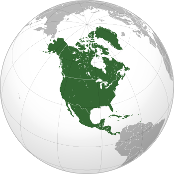 | |
|---|---|---|
Dependencies and other territories | ||