Bielle
| Bielle | |
|---|---|
| Commune | |
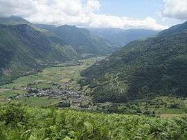 A general view of Bielle | |
 Bielle Location within Nouvelle-Aquitaine region  Bielle | |
| Coordinates: 43°03′19″N 0°25′52″W / 43.0553°N 0.4311°WCoordinates: 43°03′19″N 0°25′52″W / 43.0553°N 0.4311°W | |
| Country | France |
| Region | Nouvelle-Aquitaine |
| Department | Pyrénées-Atlantiques |
| Arrondissement | Oloron-Sainte-Marie |
| Canton | Oloron-Sainte-Marie-2 |
| Intercommunality | Vallée d'Ossau |
| Government | |
| • Mayor (2008–2014) | Jean Baylaucq |
| Area1 | 25.37 km2 (9.80 sq mi) |
| Population (2009)2 | 450 |
| • Density | 18/km2 (46/sq mi) |
| Time zone | UTC+1 (CET) |
| • Summer (DST) | UTC+2 (CEST) |
| INSEE/Postal code | 64127 /64260 |
| Elevation |
420–1,973 m (1,378–6,473 ft) (avg. 450 m or 1,480 ft) |
|
1 French Land Register data, which excludes lakes, ponds, glaciers > 1 km2 (0.386 sq mi or 247 acres) and river estuaries. 2 Population without double counting: residents of multiple communes (e.g., students and military personnel) only counted once. | |
Bielle is a commune of the Pyrénées-Atlantiques department in southwestern France.
Bielle is a classic, picturesque farming village located in the floor of a narrow valley with steeply rising mountains as a dramatic backdrop. The buildings -primarily farm houses and barns- are built of stone. The farms are laid out in polygonic lots defined by stone walls and farm buildings. The farm building are solid, simple and spacious. Bielle gently ascends a hillside, offering memorable views in all directions. A stream, with many stone bridge crossings, cascades through the village. Sheep and cattle graze in the fields. This village is magic for landscape painters who enjoy a farm-village setting.
See also
References
External links
| Wikimedia Commons has media related to Bielle (Pyrénées-Atlantiques). |