Beinan, Taitung
Coordinates: 22°47′N 121°07′E / 22.783°N 121.117°E
| Beinan Township 卑南鄉 | |
|---|---|
| Rural township | |
 | |
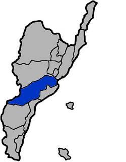 Beinan Township in Taitung County | |
| Location | Taitung County, Taiwan |
| Area | |
| • Total | 413 km2 (159 sq mi) |
| Population (July 2018) | |
| • Total | 17,322 |
| • Density | 42/km2 (110/sq mi) |
Beinan Township (Chinese: 卑南鄉; pinyin: Bēinán Xiāng; Wade–Giles: Pei1-nan2 Hsiang1; Pe̍h-ōe-jī: Pi-lâm) is a rural township in Taitung County, Taiwan. It has a population of 17,435 as of November 2017.[1]
Name and History
This south-eastern region of Taiwan was originally dominated by the Puyuma people. The township's name originates from the Puyuma language and is in memory of a great chief, Pinara.[2]
During the Dutch era, the Dutch called it Pimala. During Qing rule, access to the area (Chinese: 卑南八社) was prohibited.
In 1875, Pi-lam Subprefecture (卑南廳) was established. During the period of Japanese rule, Pinan Village (卑南庄) was established under Taitō District, Taitō Prefecture.
Geography
The northeast part of the township is located at the Huatung Valley.
Administrative divisions
The township comprises 13 villages: Binlang, Chulu, Fushan, Fuyuan, Jiafeng, Liji, Lijia, Meinong, Mingfeng, Taian, Taiping, Tungxing and Wenquan.
Tourist attractions
- Baiyu Waterfall
- Beinan Leisure Area
- Chu Lu Ranch[3]
- Jhihben National Forest Recreation Area
- Qingjue Temple
- Taromak Monument
- Yuan Sen Applied Botanical Garden
- Zhiben Hot Spring[4]
Transportation
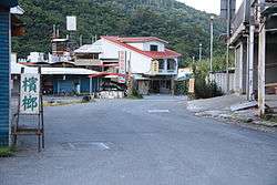
Beinan Township is accessible from Shanli Station of the Taiwan Railway Administration.
Notable natives
- A-mei, singer and songwriter
References
- ↑ "本所月戶數人口數統計(含臺東市、卑南鄉、綠島鄉、蘭嶼鄉(表1)". tth.taitung.gov.tw (in Chinese). 16 October 2012. Retrieved 1 January 2018.
- ↑ "Beinan Township". Taitung County Govt. Retrieved 15 July 2016.
- ↑ "Chulu Ranch". Tour.taitung.gov.tw. Retrieved 2014-05-14.
- ↑ "East Rift Valley National Scenic Area::PDA". Erv-nsa.gov.tw. Retrieved 2014-05-14.
External links
| Wikimedia Commons has media related to Beinan Township, Taitung. |
Cities and townships of Taitung County | ||
|---|---|---|
| Cities |  | |
| Urban townships | ||
| Rural townships | ||
| Mountain indigenous townships | ||
| Highland aboriginal Townships and Districts |
|  | ||||||||||||||||||||||||
|---|---|---|---|---|---|---|---|---|---|---|---|---|---|---|---|---|---|---|---|---|---|---|---|---|---|---|
| Plains aboriginal Townships and County-Controlled Cities |
| |||||||||||||||||||||||||
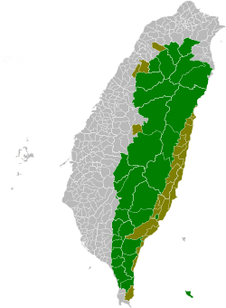
Note: On the map, "Highland aboriginal areas" are in green, and "Plains aboriginal areas" are in tan. | ||||||||||||||||||||||||||