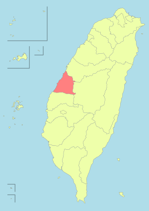
Erlin, Changhua
Coordinates: 23°55′22″N 120°24′33″E / 23.922875°N 120.409073°E
| Erlin Township 二林鎮 | |
|---|---|
| Urban township | |
 | |
 Erlin Township in Changhua County | |
| Location | Changhua County, Taiwan |
| Area | |
| • Total | 93 km2 (36 sq mi) |
| Population (July 2018) | |
| • Total | 50,772 |
| • Density | 550/km2 (1,400/sq mi) |
Erlin Township (Chinese: 二林鎮; pinyin: Èrlín Zhèn; Pe̍h-ōe-jī: Jī-lîm-tìn/Gī-lîm-tìn) is an urban township in Changhua County, Taiwan.[1]
Geography
With an area of 92.8578 square kilometers, it is the largest township in Changhua County. As of January 2017, its population was 51,487, including 26,533 males and 24,954 females.[2]
History
During the Dutch period, the area was under the administrative region of Favorlang (modern-day Huwei, Yunlin). Present-day Erlin was probably at or near Gierim, "one of the primary centers for Sino-aboriginal trade and a favorite haunt of pirates and smugglers."[3]
Administrative divisions
Fengtian, Tunghe, Nanguang, Xiping, Beiping, Zhongxi, Guangxing, Xiangtian, Waizhu, Xinghua , Tungxing, Houcuo, Dingcuo, Zhaojia, Zhenxing, Wanxing, Yongxing, Xizhuang, Meifang, Hualun, Wange, Tungshi, Dayong, Yuandou, Xidou, Tunghua and Fufeng Village.
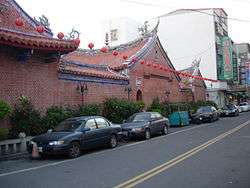
Tourist attractions
- Renhe Temple
Transportation
Bus station in the township is Erlin Bus Station of Yuanlin Bus.
Notable natives
- Liu Wen-hsiung, Member of the Legislative Yuan (1990)
- Timothy Yang, Secretary-General to the President (2012–2015)
References
- ↑ http://town.chcg.gov.tw/erhlin/01local/local01.asp
- ↑ 統計資料 | 一月 | 表四 [Statistics|January|Table 4]. accounting.chcg.gov.tw (in Chinese). Changhua County Government. 10 February 2017. Retrieved 11 February 2017.
- ↑ Andrade, Tonio (2005). "Chapter 7: The Challenges of a Chinese Frontier". How Taiwan Became Chinese: Dutch, Spanish, and Han Colonization in the Seventeenth Century. Columbia University Press. §13.
External links
| Wikimedia Commons has media related to Erlin Township, Changhua. |
- Erlin Township Website (in Chinese)