Chenggong, Taitung
Coordinates: 23°7′0″N 121°21′0″E / 23.11667°N 121.35000°E
| Chenggong Township 成功鎮 | |
|---|---|
| Urban township | |
 | |
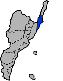 Chenggong Township in Taitung County | |
| Location | Taitung County, Taiwan |
| Area | |
| • Total | 144 km2 (56 sq mi) |
| Population (July 2018) | |
| • Total | 14,187 |
| • Density | 99/km2 (260/sq mi) |
Chenggong Township (Chinese: 成功鎮; pinyin: Chénggōng Zhèn; Wade–Giles: Ch'eng2-kung1 Chen4; Pe̍h-ōe-jī: Sêng-kong-tìn) is an urban township in Taitung County, Taiwan. It is a coastal town facing the Pacific Ocean. Fishery Harbor is just west of downtown.
History
Chenggong was originally an Amis settlement from which came the Hokkien name Moalaulau (Chinese: 麻荖漏; Pe̍h-ōe-jī: Môa-láu-lāu).[1] During Japanese rule, it was renamed to Shinkō Town (Japanese: 新港街) of Taitō Prefecture. After 1945, to avoid confusion with Xingang Township of Chiayi County and to distinguish it from Tainan's Sinckan (now called Xinshi), it was changed to Chenggong, which commemorates Zheng Chenggong who expelled the Dutch.
Geography
The township has 14,943 inhabitants and its total area is 144.9938 km². The majority inhabitants of the township are the Amis people which makes up to 53% of the population.[2]
Climate
Along with the most of the rest of Taitung County, Chenggong has a tropical monsoon climate.
| Climate data for Chenggong (1981−2010) | |||||||||||||
|---|---|---|---|---|---|---|---|---|---|---|---|---|---|
| Month | Jan | Feb | Mar | Apr | May | Jun | Jul | Aug | Sep | Oct | Nov | Dec | Year |
| Average high °C (°F) | 22.2 (72) |
22.6 (72.7) |
24.2 (75.6) |
26.5 (79.7) |
28.8 (83.8) |
30.5 (86.9) |
31.7 (89.1) |
31.6 (88.9) |
30.5 (86.9) |
28.6 (83.5) |
26.0 (78.8) |
23.2 (73.8) |
27.2 (81) |
| Daily mean °C (°F) | 18.9 (66) |
19.4 (66.9) |
21.0 (69.8) |
23.2 (73.8) |
25.2 (77.4) |
27.1 (80.8) |
28.1 (82.6) |
27.9 (82.2) |
26.8 (80.2) |
25.2 (77.4) |
22.7 (72.9) |
20.0 (68) |
23.8 (74.8) |
| Average low °C (°F) | 16.4 (61.5) |
16.8 (62.2) |
18.4 (65.1) |
20.6 (69.1) |
22.6 (72.7) |
24.3 (75.7) |
25.1 (77.2) |
24.9 (76.8) |
24.1 (75.4) |
22.5 (72.5) |
20.2 (68.4) |
17.5 (63.5) |
21.1 (70) |
| Average rainfall mm (inches) | 65.0 (2.559) |
84.0 (3.307) |
61.7 (2.429) |
82.1 (3.232) |
202 (7.95) |
221.2 (8.709) |
265.1 (10.437) |
258.0 (10.157) |
215 (8.46) |
193.7 (7.626) |
41.7 (1.642) |
64.3 (2.531) |
1,753.8 (69.039) |
| Source: Central Weather Bureau[3] Rain data 2006-2014 | |||||||||||||
Administrative divisions
- Xinyi Village 信義村
- Heping Village 和平村
- Zhongren Village 忠仁村
- Zhongzhi Village 忠智村
- Sanmin Village 三民村
- Sanxian Village 三仙村
- Zhongxiao Village 忠孝村
- Boai Village 博愛村
Demographics
Amis people are the majority ethnic group in the township.[4]
Notable people
- Teruo Nakamura (1919-1979, Attun Palalin or Lee Guang-Hui) last known Japanese hold-out to surrender after the end of hostilities in 1945
Economy
- Agriculture
- Fisheries
- Forestry
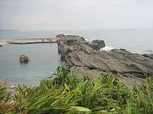
Tourist attractions
- Amis Folk Center[5]
- Chenggong Aquarium
- Chengguangao Cultural Landscape[6]
- Chengguangao Matsu Temple[7]
- Chongan Waterfall
- East Coast National Scenic Area
- Jiaping Beach
- Old Donghe Bridge
- Oceanarium
- Sanxiantai
- Shihyusan (Awana, or Stone Umbrella)
- Taitung County Museum of Natural History
- Taitung Museum of Marine Biology and Aquarium[8]
- Xiaoma Tunnel
- Xingang Harbor
- Xingang Waterfall
Transportation
- Provincial Highway No.11
- Chenggong Fish Harbor
- Xingang Port
References
- ↑ "Entry #40174 (麻荖漏)". 臺灣閩南語常用詞辭典 [Dictionary of Frequently-Used Taiwan Minnan] (in Chinese and Hokkien). Ministry of Education, R.O.C. 2011.
- ↑ "Taitung County Government English".
- ↑ "Central Weather Bureau".
- ↑ http://www.taitung.gov.tw/en/cp.aspx?n=79388C7B350E8CE9&themesite=BAA86C8F16BADDE6
- ↑ "臺東縣觀光旅遊網". 臺東縣觀光旅遊網.
- ↑ "臺東縣觀光旅遊網". 臺東縣觀光旅遊網.
- ↑ "臺東縣觀光旅遊網". 臺東縣觀光旅遊網.
- ↑ "臺東縣觀光旅遊網". 臺東縣觀光旅遊網.
| Wikimedia Commons has media related to Chenggong Township, Taitung. |
Cities and townships of Taitung County | ||
|---|---|---|
| Cities |  | |
| Urban townships | ||
| Rural townships | ||
| Mountain indigenous townships | ||
| Highland aboriginal Townships and Districts |
|  | ||||||||||||||||||||||||
|---|---|---|---|---|---|---|---|---|---|---|---|---|---|---|---|---|---|---|---|---|---|---|---|---|---|---|
| Plains aboriginal Townships and County-Controlled Cities |
| |||||||||||||||||||||||||
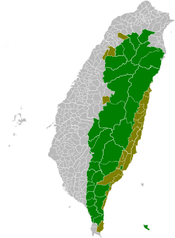
Note: On the map, "Highland aboriginal areas" are in green, and "Plains aboriginal areas" are in tan. | ||||||||||||||||||||||||||