Yunlin County
| Yunlin County 雲林縣 | |||
|---|---|---|---|
| County | |||
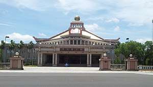
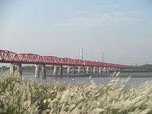
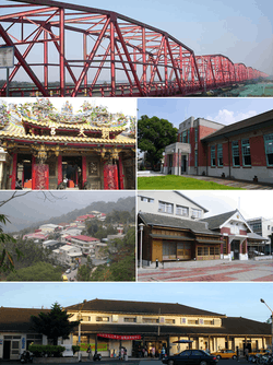 Top:Shiluo Bridge and Choushui River, Second left:Chaotian Temple in Peigang, Second right:Shinqi Memorial Museum, Third left:Caolin in Tongluo, Third right:Erlun Memorial Museum, Bottom:Dounan Railroad Station | |||
| |||
 | |||
| Coordinates: 23°42′18″N 120°28′34″E / 23.70489°N 120.47607°ECoordinates: 23°42′18″N 120°28′34″E / 23.70489°N 120.47607°E | |||
| Country | Republic of China (Taiwan) | ||
| Region | Western Taiwan | ||
| Seat | Douliu City | ||
| Largest city | Douliu City | ||
| Boroughs | 1 cities, 19 (5 urban, 14 rural) townships | ||
| Government | |||
| • County Magistrate | Lee Chin-yung (DPP) | ||
| Area | |||
| • Total | 1,290.84 km2 (498.40 sq mi) | ||
| Area rank | 13 of 22 | ||
| Population (Dec. 2014) | |||
| • Total | 705,356 | ||
| • Rank | 12 of 22 | ||
| • Density | 550/km2 (1,400/sq mi) | ||
| Time zone | UTC+8 (National Standard Time) | ||
| Website | www.yunlin.gov.tw | ||
| Symbols | |||
| Bird | Formosan blue magpie (Urocissa caerulea) | ||
| Flower | Moth orchid (Phalaenopsis) | ||
| Tree | Camphor tree (Cinnamomum camphora) | ||

| Yunlin County | |||||||||||||||
| Traditional Chinese | 雲林縣 | ||||||||||||||
|---|---|---|---|---|---|---|---|---|---|---|---|---|---|---|---|
| |||||||||||||||
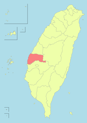
Yunlin County (Chinese: 雲林縣) is a county in western Taiwan. It is located east of the Taiwan Strait, west of Nantou County, and is separated from Changhua County by the Zhuoshui River and from Chiayi County by the Beigang River. Yunlin is part of the Chianan Plain, a flat land known for its agriculture. Agricultural products of Yunlin County include pomelo, tea leaves, suan cai, papaya and muskmelon. Yunlin's rivers give it potential for hydroelectricity. Douliu is the largest and capital city of Yunlin. Yunlin is one of the least developed counties on the West coast, and suffers from emigration.
History
Dutch Formosa
During the Dutch Formosa era, Ponkan (modern-day Beigang) was an important coastal castle.[1]
Qing Dynasty
Yunlin County was established during the Qing Dynasty. Liu Mingchuan was in charge of Taiwan, which had been divided into three counties since 1683, Yunlin being part of Zhuluo County. Mountains made transportation and communication between bordering counties (Changhua and Chiayi) difficult, so Liu suggested a new county, called Yunlin, for easier management. In 1887, Yunlin became one of the four counties of the new Taiwan Prefecture.[1]
Empire of Japan
During Japanese rule, Yunlin (as Unrin) County was again abolished due to the resistance from the local people and combined with Tainan Prefecture. However, Toroku Town (斗六街, modern-day Douliu) continued to be an important city of central Taiwan.
Republic of China
The Yunlin area stayed under Tainan County administration after the handover of Taiwan from Japan to the Republic of China on October 25, 1945. On August 16, 1950, Yunlin County was established again by separation from Tainan County, with Douliu Township as the county seat. On December 25, 1981, Douliu Township was upgraded to a county-controlled city and remain as the county seat. Today Yunlin is the only county on Taiwan island without a city with the same name.
Geography
Yunlin County is located in the central-south portion of western Taiwan and is at the northern tip of the Chianan Plain. The county is bordered by Nantou County to the east, the Taiwan Strait to the west, Chiayi County to the south separated by the Beigang River, and Changhua County to the north separated by the Zhuoshui River. Its widest distance from east to west is 50 km (31 mi) and from north to south is 38 km (24 mi), with a total area of 1,290.83 km2 (498.39 sq mi).
Geology
Around 90% of Yunlin County are plains and the other 10% are hills.[2] Generally the county is covered with high green space.[3] In 2015, the county experienced 75% of Taiwan's total land subsidence, over an area of 600 km2 (230 sq mi) due to its groundwater overuse.[4]
Climate
The weather in the county is tropical, with an annual average temperature of 22.6 °C and an average annual rainfall of 1,028.9 mm.
Administration
Yunlin County is divided into 1 city, 5 urban townships and 14 rural townships. Douliu City is the county seat and home to the Yunlin County Government and the Yunlin County Council. Lee Chin-yung of the Democratic Progressive Party is the incumbent Magistrate of Yunlin County.
| Type | Name | Chinese | Taiwanese | Hakka |
|---|---|---|---|---|
| City | Douliu City | 斗六市 | Táu-la̍k | Téu-liuk |
| Urban townships |
Beigang | 北港鎮 | Pak-káng | Pet-kóng |
| Dounan | 斗南鎮 | Táu-lâm | Téu-nàm | |
| Huwei | 虎尾鎮 | Hó͘-bóe | Fú-mî | |
| Tuku | 土庫鎮 | Thô͘-khò͘ | Thú-khù | |
| Xiluo | 西螺鎮 | Sai-lê | Sî-lô | |
| Rural townships |
Baozhong | 褒忠鄉 | Po-tiong | Pô-chûng |
| Citong | 莿桐鄉 | Chhì-tông | Tshṳ̀-thùng | |
| Dapi | 大埤鄉 | Tōa-pi | Thai-phî | |
| Dongshi | 東勢鄉 | Tang-sì | Tûng-sṳ | |
| Erlun | 二崙鄉 | Jī-lūn | Ngi-lûn | |
| Gukeng | 古坑鄉 | Kó͘-kheⁿ | Kú-hâng | |
| Kouhu | 口湖鄉 | Kháu-ô͘ | Khiéu-fù | |
| Linnei | 林內鄉 | Nâ-lāi | Lìm-nui | |
| Lunbei | 崙背鄉 | Lūn-pòe | Lûn-poi | |
| Mailiao | 麥寮鄉 | Be̍h-liâu | Ma̍k-liàu | |
| Shuilin | 水林鄉 | Chúi-nâ | Súi-lìm | |
| Sihu | 四湖鄉 | Sì-ô͘ | Si-fù | |
| Taixi | 臺西鄉 | Tâi-se | Thòi-sî | |
| Yuanchang | 元長鄉 | Goân-chiáng | Ngièn-tshòng |
Colors indicate the common language status of Hakka within each division.
Politics
Yunlin County voted two Democratic Progressive Party legislators out of two seats to be in the Legislative Yuan during the 2016 Republic of China legislative election.[5]
Demographics and Culture
| Historical population | ||
|---|---|---|
| Year | Pop. | ±% |
| 1985 | 791,186 | — |
| 1990 | 753,639 | −4.7% |
| 1995 | 753,998 | +0.0% |
| 2000 | 743,368 | −1.4% |
| 2005 | 728,490 | −2.0% |
| 2010 | 717,653 | −1.5% |
| 2015 | 699,633 | −2.5% |
| Source:"Populations by city and country in Taiwan". Ministry of the Interior Population Census. | ||
Cultural activities in the county is regulated by the Bureau of Cultural Affairs of the Yunlin County Government, which holds exhibitions, speeches, performances and studies to promote the arts and related activities.[6]
Sports
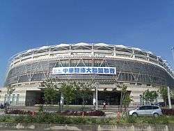
The county government promotes many sports. The Douliu Baseball Stadium and Yunlin County Stadium are two of the international-level sports facilities in the county.
The first for-all-people games were held in Yunlin County in 2000. The county also hosted the 2005 National Games. In the 2011 National Games at Changhua, Yunlin ranked 11th out of the 22 counties and cities of Taiwan, with 10 gold, 8 silver and 8 bronze medals.[7]
Economy
.jpg)
Yunlin County's economy relies mainly on agricultural production, including fresh-water fisheries, although there are also industrial parks. As of 2006, the land use for agriculture, forestry and fishery production accounts about 66.45% of its area.[3] As of July 2015, the county had a total debt of NT$64.8 billion.[8] Monthly, the county government spend NT$600 million for staffs salary and another NT$600 million for retirement funds.[9]
Agriculture
Farmlands accounts for around 68% of Yunlin County's area. Good weather and fertile lands allows various seasonal crops. Among the agricultural products are coffee, hard clams, horseshoe calms, Taiwan tilapia, shaddock, soy sauce, pickled cabbage, peanuts and sesame oil.[10]
Fishery
Yunlin County boasts excellent fishing grounds along its coastline. There are several leading fishing ports, at Boziliao, Santiaolun, Taixi, Taizicun, and Jinhu. Several institutions were established in the county to help the development of the county's fishing industries: the Taixi Experimental Fishing Grounds, the Seawater Fish Farming Research Center, the Aquaculture Experimental Station, and the Agriculture Council.
Livestock
Livestock farming includes pigs, cows, chickens, geese and ducks. The county government has been aggressively helping the dairy farmers to upgrade their feeding techniques, and also set up modern meat-packing facilities.
Tourism
The county government plans to develop the tourism and recreational industries within the county, such as by establishing a holiday fish market at the Boziliao Fishing Port in the hopes of attracting more visitors.[11]
Education
The county is home to four universities: the China Medical University Beigang Campus, the National Formosa University, the National Yunlin University of Science and Technology and the TransWorld University. There are 8 public senior high schools, 9 private high schools, 32 junior high schools and 156 elementary schools, as well as the National Yunlin Special Education School.
To promote lifelong learning, the Yunlin County Government established a community university in 2001 with 6 learning centers to offer county residents more opportunities.
Energy
Power generations
Yunlin County houses one power plant, the Mailiao Power Plant, in Mailiao Township. Commissioned in July 1999, it has a capacity of 4,200 MW and is the third largest coal-fired power plant in Taiwan.
Water supply
Currently, most of the county residence use groundwater as their water supply. However, in 2016 the Hushan Dam was opened in Douliu City in which its reservoir will soon supply the water needs for the county residence.[12]
Tourist attractions
.JPG)
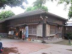
Historical buildings
Historical buildings in the county include the House of Citizen-Memorial Hall of Attendance, Jhen Wen Academy, Erlun Story House and Xiluo Theater.
Tourist towns
Caoling is the main tourist town in Yunlin County.
Temples
Temples in the county include the Chaotian Temple, Xiluo Guangfu Temple and Yong'an Temple.
Museums and cultural centers
Yunlin County is home to several museums and cultural centers, such as the Beigang Cultural Center, Farming and Irrigation Artifacts Museum, Honey Museum, Museum of Beigang Story, Soy Sauce Brewing Museum, Yunlin Hand Puppet Museum, Yunlin Story House and Zhaoan Hakka Cultural Hall.
Festivals
Festivals, such as the Beigang International Music Festival, are regularly held in the county.
Theme parks
The Janfusun Fancyworld is a theme park in the county.
Nature
Yunlin County houses the Erlun Sports Park, Penglai Waterfall and Ten Thousand Year Gorge.
Transportation
Rail
The Taiwan High Speed Rail Yunlin Station serves the county. The Taiwan Railway Administration serves at Linnei, Shiliu, Douliu, Dounan and Shigui.
Roads
The National Highway No. 1 and No. 3 pass through Yunlin County. Famous bridges in the county are the Xiluo Bridge, connecting the county to the neighboring Changhua County, and the Beigang Tourist Bridge, connecting the county to the neighboring Chiayi County.
Air
Yunlin County does not have any airport. The nearest airport is the Chiayi Airport located in neighboring Chiayi County.
Relative location
Places adjacent to Yunlin County | |
|---|---|
References
- 1 2 "Historical Evolution". The Roots of Yunlin. Yunlin County Government. Retrieved 17 December 2014.
- ↑ "The Roots of Yunlin-Geographical Location-Yunlin County Government".
- 1 2 http://a-a-r-s.org/acrs/administrator/components/com_jresearch/files/publications/P_698_9-17-10.pdf
- ↑ "Hushan Reservoir operation in July to ease land subsidence in Yunlin - Society - FOCUS TAIWAN - CNA ENGLISH NEWS". focustaiwan.tw.
- ↑ "2016 The 14th Presidential and Vice Presidential Election and The 9th Legislator Election".
- ↑ "City development-Industrial and Commercial Construction-Yunlin County Government".
- ↑ "City development-Education and Culture-Yunlin County Government".
- ↑ "Yunlin facing funds shortfall, but vows to address issue".
- ↑ "Yunlin County to face fund shortage in October".
- ↑ "Attractions > Hot Spots > Yunlin County >".
- ↑ "City development-Local industries-Yunlin County Government".
- ↑ "Hushan Reservoir to be completed in 2014".
External links
| Wikimedia Commons has media related to Yunlin County. |
- Yunlin County Government Website (in Chinese) (in English)
| Special municipalities (6) |  | |
|---|---|---|
| Cities (3) | ||
| Counties (13) | ||
| ||