Huadong Valley
Coordinates: 23°26′24″N 121°21′43″E / 23.439959°N 121.362076°E
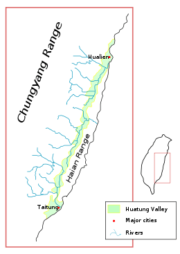
The Huadong Valley or Hualien–Taitung Valley (Chinese: 花東縱谷; pinyin: Huādōng Zònggǔ; Wade–Giles: Hua1-tung1 Tsung4-ku3), also known as East Rift Valley or the Longitudinal Valley, is a long and narrow valley located between Central Mountain Range and Hai'an Range. It is also recognized as a plain area which stretches for about 180 kilometers near the eastern coast of Taiwan, passes from Hualien City at the north to Taitung City at the south. It was called Nakasendō Plain (中仙道平野 Nakasendō Heiya) or simply Nakasendō during the era of Japanese rule.[1]
The valley is believed to be part of the northern terminus of the Philippine Mobile Belt, a complex collection of tectonic plate fragments and volcanic intrusions. There are three large river systems flowing through this valley, including the Hualian, Xiugulan and Beinan Rivers, all of which flow into the Pacific Ocean.
The Huadong Highway, a section of Provincial Highway No. 9, runs the entire length of the valley from north to south.
Gallery
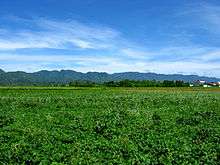 Huadong Valley; the Hai'an Range can be seen in the distance.
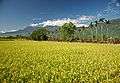 A rice paddy in the valley in Fengli, Shoufeng
 Decommissioned railway tracks by PH 9 on Ruisui
See also
References
- ↑ "East Rift Valley". RoundTAIWANRound. Retrieved 10 August 2018.
External links
| Wikimedia Commons has media related to Huatung Valley. |