Bay Ridge–95th Street (BMT Fourth Avenue Line)
Bay Ridge–95 Street | |||||||
|---|---|---|---|---|---|---|---|
|
| |||||||
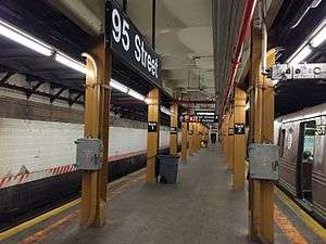 Station platform. | |||||||
| Station statistics | |||||||
| Address |
95th Street & Fourth Avenue Brooklyn, NY 11209 | ||||||
| Borough | Brooklyn | ||||||
| Locale | Fort Hamilton | ||||||
| Coordinates | 40°36′58.2″N 74°1′52.4″W / 40.616167°N 74.031222°WCoordinates: 40°36′58.2″N 74°1′52.4″W / 40.616167°N 74.031222°W | ||||||
| Division | B (BMT) | ||||||
| Line | BMT Fourth Avenue Line | ||||||
| Services |
R | ||||||
| Transit connections |
| ||||||
| Structure | Underground | ||||||
| Platforms | 1 island platform | ||||||
| Tracks | 2 | ||||||
| Other information | |||||||
| Opened | October 31, 1925[1] | ||||||
| Station code | 039[2] | ||||||
| Accessible | not ADA-accessible; accessibility planned | ||||||
| Former/other names | 95th Street–Fort Hamilton | ||||||
| Traffic | |||||||
| Passengers (2017) |
1,755,379[3] | ||||||
| Rank | 270 out of 425 | ||||||
| Station succession | |||||||
| Next north |
86th Street: R | ||||||
| Next south |
(Terminal): R | ||||||
| |||||||
| |||||||
| |||||||


Bay Ridge–95th Street (originally 95th Street–Fort Hamilton) is the southern terminal station on the BMT Fourth Avenue Line of the New York City Subway. Despite the name, the station is actually located in the Brooklyn neighborhood of Fort Hamilton (as its original name implies) at the intersection of 95th Street and Fourth Avenue. It is served by the R train at all times.
Station layout
| G | Street level | Exit/entrance |
| M | Mezzanine | Fare control, station agent, MetroCard machines |
| P Platform level |
Northbound | ← |
| Island platform, doors will open on the left or right | ||
| Northbound | ← | |
This underground station opened on October 31, 1925, with the first train leaving at 2 p.m.[1] Refurbished in the late 1970s, the station has two tracks and one island platform.[4] The tracks end at bumper blocks at the south end of the platform.[5] It was the last station to be built for the Fourth Avenue Line and is geographically the westernmost station in the subway.
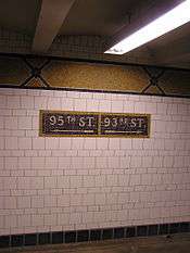
Both platform walls have their original mosaic trim line with name tablets reading "95TH STREET." in Times New Roman font along the entire station except for a small section at the north end, where the platform was extended in the 1950s to accommodate the current standard "B" Division train length of 600 feet. Here, the wall is bare black. The platforms were originally 530 feet in length.[4]
The station was constructed with a signal tower and dispatcher's office.[4]
North of this station, a center layup track forms just north of the diamond crossover, before ending at a bumper block just south of 86th Street Station.[5]
Exits
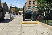
The station has two mezzanines above the platform and tracks, but mosaic directional signs indicate they were originally one full-length mezzanine. The closed-off sections are now used for employee-only spaces. The station's larger, full-time mezzanine is at the south end. It has two staircases from each platform, turnstile bank, token booth, two restrooms, and two staircases going up to either western corners of Fourth Avenue and 95th Street. A passageway leads to another staircase on the east side of the intersection, built inside an alcove of 9425 Fifth Avenue. The station's other mezzanine is unstaffed, containing one staircase from the platform, high entry/exit turnstiles, and two staircases going up to either southern corners of 93rd Street and Fourth Avenue.[6] Additional exits were planned at 94th Street, but were never built.[7]
Provisions for proposed extensions
The station is built on the west side of Fourth Avenue due to plans for a possible extension of the express tracks south of 59th Street.[8] This station had been built mainly to facilitate the Staten Island Tunnel, which would have necessitated express service but never materialized.[9][10]
South of this station, there is a false wall at the end of the tracks for a planned extension to 100th or 101st Street[11] and into the never-built Staten Island Tunnel, connecting this BMT line with the Staten Island Railway (SIRT) Main Line near its Grasmere station. The station would have also connected with the now-defunct South Beach Branch by disconnecting it from the SIRT main line, with the BMT Fourth Avenue Subway taking over service from the SIRT's Fort Wadsworth station to the Wentworth Avenue terminal. At the time it would have been a very different line had this tunnel been built, with through BMT service from Queensboro Plaza to Wentworth Avenue in Staten Island stopping at this station before proceeding to Staten Island, since this station is also the closest point to Staten Island. There were also plans to construct an underground storage yard here. The SIRT had been electrified in preparation for the tunnel, and had purchased subway cars similar to the AB Standards of the BMT.[12] The tunnel plan was amended in 1919, moving its location north to Shore Road in Bay Ridge.[13]
Later proposals surfaced to connect the station to the Verrazano-Narrows Bridge, one of the world's longest suspension bridges, which follows the route of the planned tunnel. The bridge was built without provisions for rail traffic.[9][12][14]
References
- 1 2 "95th St. Subway Extension Opened At 2 P. M. Today". Brooklyn Daily Eagle. October 31, 1925. Retrieved 29 June 2015 – via Newspapers.com.
- ↑ "Station Developers' Information". Metropolitan Transportation Authority. Retrieved June 13, 2017.
- ↑ "Facts and Figures: Annual Subway Ridership 2012–2017". Metropolitan Transportation Authority. July 12, 2018. Retrieved July 12, 2018.
- 1 2 3 "Subway Bids Announced: For 95th Street Terminal, Brooklyn, and Corona Yard" (PDF). nytimes.com. The New York Times. March 1, 1925. Retrieved 28 June 2015.
- 1 2 Dougherty, Peter (2006) [2002]. Tracks of the New York City Subway 2006 (3rd ed.). Dougherty. OCLC 49777633 – via Google Books.
- ↑ "MTA Neighborhood Maps: Bay Ridge" (PDF). mta.info. Metropolitan Transportation Authority. 2015. Retrieved 29 June 2015.
- ↑ "Locates Extension Station: Transit Board Decides on 93d-95th St,. Brooklyn, Site" (PDF). nytimes.com. The New York Times. September 13, 1922. Retrieved 29 June 2015.
- ↑ "Brooklyn Subway Extension Plan: Fourth Ave. Line to 86th St., Tunnel to Staten Island, and Eventually a Through Route to Coney Island" (PDF). nytimes.com. The New York Times. February 16, 1912. Retrieved 28 June 2015.
- 1 2 "To Extend Subway to Fort Hamilton" (PDF). nytimes.com. The New York Times. August 26, 1922. Retrieved 27 June 2015.
- ↑ "Three Rapid Transit Contracts are Let" (PDF). nytimes.com. The New York Times. December 29, 1922. Retrieved 28 June 2015.
- ↑ "Discuss Subway Work: Fort Hamilton Taxpayers Want 100th Street Extended" (PDF). nytimes.com. The New York Times. September 24, 1911. Retrieved 28 June 2015.
- 1 2 Leigh, Irvin; Matus, Paul (January 2002). "State Island Rapid Transit: The Essential History". thethirdrail.net. The Third Rail Online. Archived from the original on 30 May 2015. Retrieved 27 June 2015.
- ↑ "To Act This Year on the Richmond Tube: Route Approved in 1912 Still Alive-May Soon Be Adopted Anew or Amended" (PDF). nytimes.com. The New York Times. February 13, 1919. Retrieved 27 June 2015.
- ↑ Martin, Douglas (November 17, 1996). "Subway Planners' Lofty Ambitions Are Buried as Dead-End Curiosities". nytimes.com. The New York Times. Retrieved 27 June 2015.
External links
| Wikimedia Commons has media related to Bay Ridge – 95th Street (BMT Fourth Avenue Line). |
- nycsubway.org – BMT 4th Avenue Line: 95th Street/Fort Hamilton
- Station Reporter — R Train
- The Subway Nut - Bay Ridge–95th Street Station Pictures
- 95th Street entrance from Google Maps Street View
- Platform from Google Maps Street View