Aylesbury Vale
| Aylesbury Vale District | |
|---|---|
| Non-metropolitan district | |
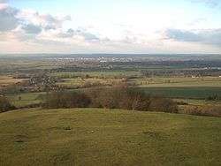 Part of Aylesbury Vale taken from the top of Coombe Hill, looking towards Aylesbury | |
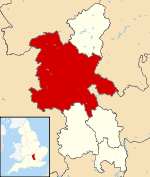 Aylesbury Vale shown within Buckinghamshire | |
| Sovereign state | United Kingdom |
| Constituent country | England |
| Region | South East England |
| Non-metropolitan county | Buckinghamshire |
| Status | Non-metropolitan district |
| Admin HQ | Aylesbury |
| Incorporated | 1 April 1974 |
| Government | |
| • Type | Non-metropolitan district council |
| • Body | Aylesbury Vale District Council |
| • Leadership | Leader & Cabinet (Conservative) |
| • MPs |
John Bercow (Speaker) David Lidington (Conservative) |
| Area | |
| • Total | 348.55 sq mi (902.75 km2) |
| Area rank | 36th (of 326) |
| Population (mid-2017 est.) | |
| • Total | 196,000 |
| • Rank | 91st (of 326) |
| • Density | 560/sq mi (220/km2) |
| • Ethnicity |
92.3% White 3.7% S.Asian 1.5% Black 1.5% Mixed 1.0% Chinese or Other |
| Time zone | UTC0 (GMT) |
| • Summer (DST) | UTC+1 (BST) |
| ONS code |
11UB (ONS) E07000004 (GSS) |
| OS grid reference | SP818138 |
| Website |
www |
The Aylesbury Vale (or Vale of Aylesbury) is a large area of gently rolling agricultural landscape located in the northern half of Buckinghamshire, England. Its boundary is marked by the Borough of Milton Keynes and South Northamptonshire to the north, Central Bedfordshire and the Borough of Dacorum (Hertfordshire) to the east, the Chiltern Hills and Wycombe to south, and South Oxfordshire to the west.
The vale is named after Aylesbury, the county town of Buckinghamshire. The two other towns which lie within the vale are Winslow and Buckingham.
The bed of the vale is largely made up of clay that was formed at the end of the ice age. Also at this time the vast underground reserves of water that make the water table in the Vale of Aylesbury higher than average, were created. In the 2011 UK census the population of Aylesbury Vale was 174,900. In the 2001 UK census the population of Aylesbury Vale was 165,748, representing an increase since 1991 of 18,600 people.[1] About half of those live in the county town Aylesbury.
Government
Aylesbury Vale is a local government district of northern Buckinghamshire, administered by a district council.[2] The district was formed on 1 April 1974 by the merger of the boroughs of Aylesbury and Buckingham, Aylesbury Rural District, Buckingham Rural District, Wing Rural District and part of Winslow Rural District. The district offices are based in Aylesbury. The district council's logo includes the historical figure of John Hampden.
There are 111 civil parishes: 84 with a parish council, including three town councils (Aylesbury, Buckingham and Winslow), and a further 27 operating with a Parish meeting, see list of civil parishes in Aylesbury Vale.
Elections to the district council take place every 4 years, with 59 councillors being elected from 36 wards. Since winning a majority at the 2003 election the Conservative party has held control of the council. Following the latest election in 2015, and subsequent vacancies, by-elections and defections as of the 3rd May 2018, party strengths are as follows:[3]
| Year | Con | LD | UKIP | Lab | Ind | Vac |
|---|---|---|---|---|---|---|
| 2015 | 43 | 8 | 4 | 2 | 1 | 0 |
| 2018 | 40 | 12 | 0 | 2 | 4 | 1 |
Transport
The district contains no motorway junctions, although the M40 does enter the district for five miles between junctions 8A and 9. Major roads include the A41, A413 and A418- which all meet at Aylesbury. The A421 passes through the north of the district providing connections to Milton Keynes, Bedford and the M1 to the east, and the M40 and Oxford and Birmingham to the west.
For its size, the district contains relatively few railway stations; most of its stations are in the very south of the district along the London to Aylesbury Line- the major station being Aylesbury. At Aylesbury there are connecting services to Princes Risborough station. In addition, the West Coast and Chiltern main lines both pass through the district, each having a station within the district.
Tourism
The district has a number of historic buildings and landscapes which are popular tourist attractions. The National Trust owns several properties including Waddesdon Manor, Claydon House and the landscaped gardens at Stowe House. The Silverstone Circuit sits on the northern boundary of the district with South Northamptonshire, and the Buckinghamshire Railway Centre is located near Quainton.
Aylesbury is home to the County Museum (which includes the Roald Dahl Children's Gallery), and Buckingham features the Old Gaol Museum.
References
- ↑ UK Census 2001
- ↑ Aylesbury Vale District Council website
- ↑ "Aylesbury Vae District Council Concillors 2015". Aylesbury Vale District Council. Archived from the original on 17 July 2015. Retrieved 16 July 2015.
Buckinghamshire Portal | |
| Unitary authorities | |
| Boroughs or districts | |
| Major settlements | |
| Rivers | |
| Topics | |