West Oxfordshire
| West Oxfordshire District | |
|---|---|
| Non-metropolitan district | |
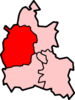
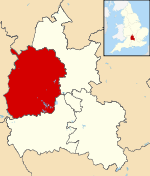 West Oxfordshire shown within Oxfordshire | |
| Sovereign state | United Kingdom |
| Constituent country | England |
| Region | South East England |
| Non-metropolitan county | Oxfordshire |
| Status | Non-metropolitan district |
| Admin HQ | Witney |
| Incorporated | 1 April 1974 |
| Government | |
| • Type | Non-metropolitan district council |
| • Body | West Oxfordshire District Council |
| • Leadership | Leader & Cabinet (Conservative) |
| • MPs | Robert Courts |
| Area | |
| • Total | 275.83 sq mi (714.40 km2) |
| Area rank | 53rd (of 326) |
| Population (mid-2017 est.) | |
| • Total | 109,300 |
| • Rank | 218th (of 326) |
| • Density | 400/sq mi (150/km2) |
| • Ethnicity | 98.4% White |
| Time zone | UTC0 (GMT) |
| • Summer (DST) | UTC+1 (BST) |
| ONS code |
38UF (ONS) E07000181 (GSS) |
| OS grid reference | SP3591610698 |
| Website |
www |
West Oxfordshire is a local government district in northwest Oxfordshire, England, including towns such as Woodstock, Burford, Chipping Norton, Charlbury, Carterton and Witney, where the council is based.
The area is mainly rural downland and forest, the main activities being farming and associated trades.
The district was created on 1 April 1974, under the Local Government Act 1972, by the merger of the municipal borough of Chipping Norton, Witney urban district, and Chipping Norton and Witney Rural Districts.
West Oxfordshire lies within the River Thames catchment area, with the Thames itself and its tributaries including the River Evenlode and River Windrush running through the area.[1] Parts of the district suffered severe flooding during the 2007 floods in the UK.[2]
Governance
Elections to West Oxfordshire District Council are held in three out of every four years, with one third of the seats on the council being elected at each election. Since the first election to the council in 1973 the only political party to have had a majority on the council is the Conservative party, although there have been periods where no party has had a majority and independents had a majority from 1973 to 1976 and from 1990 to 1992. Since the 2000 election the Conservatives have controlled the council and as of the 2018 Local Elections the council is compromised of the following councillors:[3]
| Party | Councillors | |
| Conservative | 32 | |
| Liberal Democrat | 8 | |
| Labour | 6 | |
| Independent | 3 | |
References
- ↑ West Oxfordshire District Council - Preparing for Flooding
- ↑ Witney Flood Gallery
- ↑ "West Oxfordshire District Council - Councillor information". www.westoxon.gov.uk. Retrieved 2018-06-06.
Oxfordshire Portal | |
| Boroughs or districts | |
| Major settlements | |
| Topics | |
Coordinates: 51°47′36″N 1°28′45″W / 51.79333°N 1.47917°W