Chiltern District
| Chiltern District | |
|---|---|
| Non-metropolitan district | |
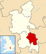 Chiltern shown within Buckinghamshire | |
| Sovereign state | United Kingdom |
| Constituent country | England |
| Region | South East England |
| Non-metropolitan county | Buckinghamshire |
| Status | Non-metropolitan district |
| Admin HQ | Amersham |
| Incorporated | 1 April 1974 |
| Government | |
| • Type | Non-metropolitan district council |
| • Body | Chiltern District Council |
| • Leadership | Leader & Cabinet (Conservative) |
| • MPs | Cheryl Gillan |
| Area | |
| • Total | 75.81 sq mi (196.35 km2) |
| Area rank | 168th (of 326) |
| Population (mid-2017 est.) | |
| • Total | 95,400 |
| • Rank | 256th (of 326) |
| • Density | 1,300/sq mi (490/km2) |
| • Ethnicity |
91.4% White 5.5% Asian 0.6% Black 2.2% Mixed Race 0.3% Other (2,011 Census)[1] |
| Time zone | UTC0 (GMT) |
| • Summer (DST) | UTC+1 (BST) |
| ONS code |
11UC (ONS) E07000005 (GSS) |
| OS grid reference | SU965985 |
| Website |
www |
Chiltern is one of four local government districts of Buckinghamshire in south central England. It is named after the Chiltern Hills on which the region sits.
The main towns in the district are Amersham and Chesham which are both served by London Underground's Metropolitan line.
History
It was formed on 1 April 1974 by the merger of the Chesham Urban District and surrounding Amersham Rural District. In 1988 it was the first Council to take up stock transfer.[2] 4,650 homes were transferred.[3]
Parishes
The parishes that make up Chiltern District are:
- Amersham
- Ashley Green
- Chalfont St. Giles
- Chalfont St Peter
- Chartridge
- Chenies
- Chesham
- Chesham Bois
- Cholesbury-cum-St Leonards
- Coleshill
- Great Missenden
- Latimer
- Little Chalfont
- Little Missenden
- Penn
- Seer Green
- The Lee
See also the list of civil parishes in Buckinghamshire
Council affiliation
As of 23 March 2018, the council composition is as follows:[4]
| Party | Number of councillors | |
|---|---|---|
| Conservatives | 38 | |
| Liberal Democrats | 2 | |
Transport
Along with the Aylesbury Vale district, Chiltern contains no motorways except for a very small section of the M25 in the south-eastern corner. The major roads through the district are the A413 and the A404, the two meeting in Amersham. Railway services are provided by Chiltern Railways and London Underground's Metropolitan line. The Great Central Main Line carried traffic between London and Manchester until 1966, the section to Aylesbury is all that remains, and is now part of the London to Aylesbury Line. The railway stations in the district are; Great Missenden, Amersham, Chalfont and Latimer and Chesham, the furthest tube station from London.
Law and order
Police stations are in Amersham and Chesham. The Magistrates' Court in Amersham was closed with its jurisdiction reassigned but reopened as a Crown Court dealing with either-way and more serious alleged offences.
Home ownership and quality of rural life
The district has the highest proportion of home ownership of the 18 local authorities in Bedfordshire, Buckinghamshire and Hertfordshire: combining the social (housing association and local authority provided) and private rented sectors, Stevenage's returns recorded in 2011 that its rented sector comprised 33.2% of its housing, whereas 10.0% of Chiltern's residents rented their homes.
In May 2008, the district was assessed by Bank of Scotland, Halifax division as having the best rural quality of life anywhere in Britain.[5]
| Form of home ownership in Beds, Bucks and Herts compared[6] | |||||
|---|---|---|---|---|---|
| Local Authority | Owned | Owned with a loan | Socially rented | Privately rented | Other |
| Chiltern | 41.1 | 35.8 | 1.8 | 8.2 | 1 |
| South Bucks | 38.1 | 35.3 | 12.3 | 10 | 1.4 |
| St Albans | 34.6 | 38.2 | 8.5 | 12.6 | 1.1 |
| Three Rivers | 34.1 | 38.6 | 4.8 | 9.3 | 1 |
| Broxbourne | 32.6 | 40.4 | 2.9 | 10.4 | 0.8 |
| Wycombe | 32.3 | 37.4 | 8.5 | 13.1 | 1.4 |
| East Hertfordshire | 32.1 | 39.7 | 2 | 12.2 | 1.4 |
| Central Bedfordshire | 31.6 | 40.9 | 5.2 | 10.5 | 1.1 |
| Bedford | 31.4 | 34.3 | 1.8 | 14.6 | 1.3 |
| Hertsmere | 31.4 | 36.2 | 1.9 | 11.3 | 1.2 |
| Aylesbury Vale | 31.1 | 40.5 | 3.4 | 11.7 | 1.3 |
| North Hertfordshire | 30.3 | 35.3 | 7.1 | 12.1 | 1.1 |
| Dacorum | 29.1 | 35.7 | 17.4 | 10.9 | 0.9 |
| Welwyn Hatfield | 26.5 | 30.8 | 19.9 | 12.7 | 1.3 |
| Luton | 25.1 | 35.1 | 10.7 | 21.3 | 1 |
| Watford | 24.4 | 37.2 | 4 | 18.9 | 0.8 |
| Stevenage | 22.2 | 36.1 | 22.8 | 10.4 | 0.7 |
| Milton Keynes | 21.5 | 36.3 | 11 | 16.2 | 0.9 |
Energy consumption
In May 2006, a report commissioned by British Gas[7] showed that housing in Chiltern produced the 4th highest average carbon emissions in the country at 7,421 kg of carbon dioxide per dwelling.
References
- ↑ 2011 Census: KS201EW Ethnic group, local authorities in England and Wales, Accessed 28 February 2013
- ↑ "Transfers - Large Scale Voluntary Transfers (LSVT)". The Hidden History of Tenants. Leeds Tenants Federation. Archived from the original on 4 March 2016. Retrieved 17 September 2015.
- ↑ Hetherington, Peter. "Voluntary transfer for social housing celebrates 10 years". Guardian. Guardian. Retrieved 17 September 2015.
- ↑ "Council and Democracy". isa.chiltern.gov.uk. United Kingdom. 2018-03-23. Retrieved 2018-03-23.
- ↑ HBOS quality of life survey Archived 2008-06-27 at the Wayback Machine. 5 May 2008. Retrieved 2015-01-28.
- ↑ Office for National Statistics 2011 Census Key Statistics: Tenure. Shared ownership forms the small remainder of each proportion.
- ↑ British Gas news Archived 2008-06-26 at the Wayback Machine.
External links
| Towns (component areas and hamlets) | 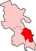 | |
|---|---|---|
| Other civil parishes (component villages and hamlets) | ||
| Former districts and boroughs | ||
| Former constituencies | ||
Buckinghamshire Portal | |
| Unitary authorities | |
| Boroughs or districts | |
| Major settlements | |
| Rivers | |
| Topics | |