Borough of Runnymede
Coordinates: 51°23′42″N 0°32′28″W / 51.395°N 0.541°W
| Borough of Runnymede | |
|---|---|
| Non-metropolitan district | |
| Motto(s): In Freedom We Serve | |
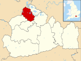 Runnymede shown within Surrey | |
| Sovereign state | United Kingdom |
| Constituent country | England |
| Region | South East England |
| Non-metropolitan county | Surrey |
| Status | Non-metropolitan district |
| Admin HQ | Addlestone |
| Incorporated | 1 April 1974 |
| Government | |
| • Type | Non-metropolitan district council |
| • Body | Runnymede Borough Council |
| • Leadership | Alternative - Sec.31 (Conservative) |
| • MPs | Philip Hammond |
| Area | |
| • Total | 30.1 sq mi (78.0 km2) |
| Area rank | 245th (of 326) |
| Population (mid-2017 est.) | |
| • Total | 86,900 |
| • Rank | 282nd (of 326) |
| • Density | 2,900/sq mi (1,100/km2) |
| • Ethnicity |
92.5% White 2.9% S.Asian 1.1% Black 1.5% Mixed 1.9% Chinese or Other |
| Time zone | UTC0 (GMT) |
| • Summer (DST) | UTC+1 (BST) |
| ONS code |
43UG (ONS) E07000212 (GSS) |
| OS grid reference | TQ0149367283 |
| Website |
www |
The Borough of Runnymede is a local government district with borough status in the English county of Surrey. It is a very prosperous part of the London commuter belt, with some of the most expensive housing in the United Kingdom outside central London, such as the Wentworth Estate.
Runnymede is entirely unparished and is largely built-up. The borough's council is based in Addlestone; other settlements include Chertsey, Egham, Egham Hythe, Virginia Water, Englefield Green and Thorpe. At the 2011 Census, the population of the borough was 80,510.[1]
The borough was formed in 1974 under the Local Government Act 1972 by the merger of the Chertsey and Egham Urban Districts, both of which had been created in 1894. It is named after Runnymede, a water meadow on the banks of the River Thames, near Egham. Runnymede is connected with the sealing of Magna Carta by King John in 1215 and is the site of several significant monuments.
Runnymede borders the boroughs of Spelthorne, Elmbridge, Woking and Surrey Heath, as well as the Royal Borough of Windsor and Maidenhead in Berkshire. The M25 motorway runs through Runnymede from south to north, with junctions at Chertsey and Egham, while train services in the borough are provided by South Western Railway on the Waterloo–Reading line and the Chertsey branch line.
At the 2007 elections, the borough was held by the Conservative Party with 36 seats, while the Runnymede Residents Association obtained six seats. This result was unchanged from the last election.[2]
Twinning
Runnymede is twinned with Bergisch Gladbach, situated 10 miles east of Cologne; Herndon, Virginia, about 20 miles west of Washington, D.C.; and Joinville-le-Pont, located to the east of Paris.
Borough Council Committees
- Corporate Management Committee
- Environment and Sustainability Committee
- Housing Committee
- Standards and Audit Committee
- Overview and Scrutiny Select Committee
- Regulatory
- Planning Committee
- Licensing Committee and Sub-Committee
- Crime and Disorder Committee
- Community Services Committee
- Addlestone Leisure Centre JMC
- Chertsey Meads Management Liaison Group
- Cabrera Trust Management Committee
- External Appointments Sub-Committee [3]
The budgetary strategy and political agenda are set by The Leader and Deputy Leader of the Council.
The role of the Mayor of Runnymede is to chair full council meetings and perform ceremonial duties.
Elections
This Council has held elections by thirds (resulting in elections in May in three out of four years) since its inception. Most of its wards have three councillors. Immediately before each election a different councillor's seat from the others at ward level is legally vacant.
References
- ↑ "Borough profile". Runnymede Borough Council. Retrieved 25 December 2017.
- ↑ "Vote 2007: English councils map". BBC News. Retrieved 9 May 2007.
- ↑ "Page not found". www.runnymede.gov.uk.