Arun District
| Arun District | |
|---|---|
| Non-metropolitan district | |
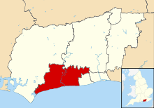 Arun shown within West Sussex | |
| Sovereign state | United Kingdom |
| Constituent country | England |
| Region | South East England |
| Non-metropolitan county | West Sussex |
| Status | Non-metropolitan district |
| Admin HQ | Littlehampton |
| Incorporated | 1 April 1974 |
| Government | |
| • Type | Non-metropolitan district council |
| • Body | Arun District Council |
| • Leadership | Leader & Cabinet (Conservative) |
| • MPs |
Peter Bottomley Nick Gibb Nick Herbert |
| Area | |
| • Total | 85.3 sq mi (221.0 km2) |
| Area rank | 159th (of 326) |
| Population (mid-2017 est.) | |
| • Total | 158,700 |
| • Rank | 121st (of 326) |
| • Density | 1,900/sq mi (720/km2) |
| • Ethnicity |
96.7% White 1.1% S.Asian |
| Time zone | UTC0 (GMT) |
| • Summer (DST) | UTC+1 (BST) |
| ONS code |
45UC (ONS) E07000224 (GSS) |
| OS grid reference | TQ029020 |
| Website |
www |
Arun is a local government district in West Sussex, England. It contains the towns of Arundel, Bognor Regis and Littlehampton, and takes its name from the River Arun, which runs through the centre of the district.[1]
History
Arun was formed on 1 April 1974, under the Local Government Act 1972, merging the Urban Districts of Bognor Regis and Littlehampton, the municipal borough of Arundel and parts of Chichester and Worthing Rural Districts.
Governance
The council has been under the control of the Conservative Party since its first election in 1973. The last elections to the council were held on 7 May 2015.[2] Following those elections and subsequent by-elections,[3] the composition of the council is as follows:
| Arun District Council Composition | ||||||||
|---|---|---|---|---|---|---|---|---|
| Party | Seats | |||||||
| Conservatives | 44 | |||||||
| Liberal Democrats | 5 | |||||||
| UK Independence Party and Independent Group | 3 | |||||||
| Labour | 1 | |||||||
| Independent | 1 | |||||||
Arun District Council is a non-metropolitan district council formed of 54 councillors from across the following 23 wards:[4]
| Ward | Councillors |
|---|---|
| Aldwick East | 2 |
| Aldwick West | 2 |
| Angmering & Findon | 3 |
| Arundel & Walberton | 3 |
| Barnham | 3 |
| Beach (Littlehampton) | 2 |
| Bersted | 3 |
| Brookfield (Littlehampton) | 2 |
| Courtwick with Toddington | 3 |
| East Preston | 3 |
| Felpham East | 2 |
| Felpham West | 2 |
| Ferring | 2 |
| Hotham (Bognor Regis) | 2 |
| Marine (Bognor Regis) | 2 |
| Middleton-on-Sea | 2 |
| Orchard (Bognor Regis) | 2 |
| Pagham | 2 |
| Pevensey (Bognor Regis) | 2 |
| River (Littlehampton) | 3 |
| Rustington East | 2 |
| Rustington West | 3 |
| Yapton | 2 |
Civil parishes
The following 31 civil parishes are located within the district:[5]
| Parish | Type | Area (Hectare) | Population (2001) | Pop Density /Hectare |
|---|---|---|---|---|
| Aldingbourne | Parish Council | 1253 | 3612 | 2.88 |
| Aldwick | Parish Council | 425 | 10884 | 25.61 |
| Angmering | Parish Council | 1782 | 5639 | 3.16 |
| Arundel | Town Council | 1227 | 3408 | 2.78 |
| Barnham | Parish Council | 373 | 1372 | 3.68 |
| Bersted | Parish Council | 713 | 8443 | 11.85 |
| Bognor Regis | Town Council | 486 | 22555 | 46.44 |
| Burpham | Parish Meeting | 1245 | 193 | 0.15 |
| Clapham | Parish Council | 515 | 317 | 0.62 |
| Climping | Parish Council | 691 | 600 | 0.87 |
| East Preston | Parish Council | 241 | 5919 | 24.53 |
| Eastergate | Parish Council | 371 | 3107 | 8.39 |
| Felpham | Parish Council | 426 | 9611 | 24.53 |
| Ferring | Parish Council | 431 | 4361 | 10.13 |
| Findon | Parish Council | 1614 | 1848 | 1.14 |
| Ford | Parish Council | 415 | 1358 | 3.27 |
| Houghton | Parish Meeting | 743 | 76 | 0.10 |
| Kingston | Parish Council | 229 | 702 | 3.07 |
| Littlehampton | Town Council | 1135 | 25593 | 22.55 |
| Lyminster | Parish Council | 587 | 351 | 0.60 |
| Madehurst | Parish Meeting | 766 | 105 | 0.14 |
| Middleton-on-Sea | Parish Council | 412 | 5105 | 12.41 |
| Pagham | Parish Council | 1059 | 5729 | 5.41 |
| Patching | Parish Council | 846 | 230 | 0.27 |
| Poling | Parish Meeting | 320 | 173 | 0.54 |
| Rustington | Parish Council | 432 | 13210 | 30.60 |
| Slindon | Parish Council | 1286 | 590 | 0.46 |
| South Stoke | Parish Meeting | 535 | 44 | 0.08 |
| Walberton | Parish Council | 1044 | 1941 | 1.86 |
| Warningcamp | Parish Meeting | 378 | 161 | 0.43 |
| Yapton | Parish Council | 791 | 3522 | 4.46 |
| Arun | Total | 22770 | 140759 | 6.18 |
Geography
Arun District occupies the central southern area of West Sussex, and is bordered by Chichester District to the west, Horsham District to the north and Worthing borough and Adur District to the east. The district is bisected by the River Arun, and is divided between a broad rural area in the north of the district that contains Arundel and a host of small villages, part of which sits within the South Downs National Park, and an urban coastal strip that includes Bognor Regis and Littlehampton.
Economy
Although set within the typically prosperous county of West Sussex, much of Bognor Regis and Littlehampton are ranked amongst the 20% most deprived areas in the UK as a whole on the Index of Multiple Deprivation.[6] The district contains a large tourism sector, attracting visitors to the South Downs in the north, and the beaches of Bognor Regis and Littlehampton in the south, the latter of which holds a prestigious Blue Flag Award.[7] Consequently, the district suffers from high amounts of seasonal employment, with the Office for National Statistics estimating that nearly 11% of the population of Arun is employed in the tourism sector, compared to 8% nationally, whilst 28% of people work in the distribution, hotels and restaurants sector, compared to just 23% nationally. Arun also has a higher number of public sector workers than either the regional or national average, and a significantly smaller finance and IT sector than the rest of the South East and wider UK.
Awards
In 2008, the district council won an Ashden Award for their work on energy efficiency.[8]
Football clubs
See also
References
- ↑ "Arun" in The New Encyclopædia Britannica. Chicago: Encyclopædia Britannica Inc., 15th edn., 1992, Vol. 1, p. 609.
- ↑ https://www.bbc.co.uk/news/special/election2011/council/html/45uc.stm
- ↑ http://www.arun.gov.uk/mediaFiles/downloads/54457531/Declaration_of_Result_of_Poll.pdf%5Bpermanent+dead+link%5D
- ↑ "Ward Profiles". Arun District Council. Retrieved 27 March 2009.
- ↑ "2001 Census: West Sussex – Population by Parish" (PDF). West Sussex County Council. Archived from the original (PDF) on 8 June 2011. Retrieved 26 March 2009.
- ↑ "Index of Multiple Deprivation". West Sussex County Council. Archived from the original on 18 March 2012. Retrieved 12 April 2011.
- ↑ "Littlehampton Coastguards". Blue Flag. Retrieved 12 April 2011.
- ↑ "District council brings energy efficiency throughout its operations". Ashden Awards. Archived from the original on 15 June 2009. Retrieved 22 May 2009.
Coordinates: 50°48′29.7″N 0°32′18.6″W / 50.808250°N 0.538500°W