Rugby (district)
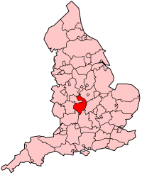
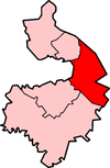
Rugby is een stad en Engels district in het shire-graafschap (non-metropolitan county OF county) Warwickshire en telt 107.000 inwoners. De oppervlakte bedraagt 351 km².
| Niet-metropolitaans district in Engeland | |||
  | |||
| Situering | |||
| Land | Engeland | ||
| County | Warwickshire | ||
| Regio | West Midlands | ||
| Coördinaten | 52°22'31"NB, 1°15'49"WL | ||
| Algemeen | |||
| Oppervlakte | 351,1133[1] km² | ||
| Inwoners (2018[2]) | 107194 (305 inw./km²) | ||
| ONS-code | E07000220 | ||
| |||
Van de bevolking is 16,1% ouder dan 65 jaar. De werkloosheid bedraagt 2,6% van de beroepsbevolking (cijfers volkstelling 2001).
De hoofdstad Rugby telt circa 62.790 inwoners.
Civil parishes in district Rugby
Ansty, Binley Woods, Birdingbury, Bourton and Draycote, Brandon and Bretford, Brinklow, Burton Hastings, Cawston, Church Lawford, Churchover, Clifton upon Dunsmore, Combe Fields, Copston Magna, Cosford, Dunchurch, Easenhall, Frankton, Grandborough, Harborough Magna, King’s Newnham, Leamington Hastings, Little Lawford, Long Lawford, Marton, Monks Kirby, Newton and Biggin, Pailton, Princethorpe, Ryton-on-Dunsmore, Shilton and Barnacle, Stretton Baskerville, Stretton under Fosse, Stretton-on-Dunsmore, Thurlaston, Wibtoft, Willey, Willoughby, Withybrook, Wolfhampcote, Wolston, Wolvey.
Bronnen, noten en/of referenties
|