Westport, Connecticut
Westport is a town in Fairfield County, Connecticut, United States, along Long Island Sound within Connecticut's Gold Coast. It is 52 miles (84 km) northeast of New York City. The town had a population of 26,391 according to the 2010 U.S. Census, and is ranked 19th among America's 100 Richest Places[5] as well as third[5] in Connecticut, with populations between 20,000 and 65,000.[6][7]
Westport, Connecticut Town of Westport | |
|---|---|
 Westport Town Hall | |
 Flag  Seal | |
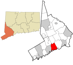 Location in Fairfield County and the state of Connecticut. | |
| Coordinates: 41°07′24″N 73°20′49″W | |
| Country | |
| U.S. state | |
| County | Fairfield |
| Metropolitan area | Bridgeport-Stamford |
| Established | 1835 |
| Incorporated | May 28, 1835 |
| Founded by | Bankside Farmers |
| Government | |
| • Type | RTM |
| • 1st Selectman | Jim Marpe (R) |
| • 2nd Selectwoman | Jennifer Tooker (R) |
| • 3rd Selectwoman | Melissa Kane (D) |
| Area | |
| • Total | 33.45 sq mi (86.6 km2) |
| • Land | 19.96 sq mi (51.7 km2) |
| • Water | 13.49 sq mi (34.9 km2) |
| Elevation | 26 ft (8 m) |
| Population | |
| • Total | 26,391 |
| • Density | 1,322.2/sq mi (510.5/km2) |
| Time zone | UTC−5 (Eastern) |
| • Summer (DST) | UTC−4 (Eastern) |
| ZIP Code | 06880 |
| PO Boxes | 06881 |
| Area code(s) | 203/475 |
| FIPS code | 09-83500 |
| GNIS feature ID | 0213532 |
| Website | Westport, Connecticut |
History
The earliest known inhabitants of the Westport area as identified through archaeological finds date back 7,500 years.[8] Records from the first white settlers report the Pequot Indians living in the area which they called Machamux translated by the colonialists as beautiful land.[9] Settlement by colonialists dates back to the five Bankside Farmers; whose families grew and prospered into a community that continued expanding. The settlers arrived in 1693, having followed cattle to the isolated area.[9] The community had its own ecclesiastical society, supported by independent civil and religious elements, enabling it to be independent from the Town of Fairfield.[10] As the settlement expanded its name changed: it was briefly known as "Bankside" in 1693, officially named Green's Farm in 1732 in honor of Bankside Farmer John Green and in 1835 incorporated as the Town of Westport.[8][11]

During the revolutionary war—on April 25, 1777, a British force of 1,850 under the command of the Royal Governor of the Province of New York, Major General William Tryon landed on Compo Beach to destroy the Continental Army’s military supplies in Danbury.[12] Minutemen from Westport and the surrounding areas crouched hiding while Tryon's troops passed and then launched an offensive from their rear. A statue on Compo beach commemorates this plan of attack with a crouching Minuteman facing away from the beach, looking onto what would have been the rear of the troops.[13] A sign on Post Road East also commemorates this event.[14]
The Town of Westport was officially incorporated on May 28, 1835, with lands from Fairfield, Weston and Norwalk.[8][15] Daniel Nash led 130 people of Westport in the petitioning of the Town of Fairfield for Westport’s incorporation. The driving force behind the petition was to assist their seaport’s economic viability that was being undermined by neighboring towns’ seaports.[16] For several decades after that, Westport was a prosperous agricultural community distinguishing itself as the leading onion-growing center in the U.S.[17] Blight caused the collapse of Westport's onion industry, leading to mills and factories replacing agriculture as the town's economic engine.[10]
Agriculture was Westport's first major industry. By the 19th century, Westport had become a shipping center in part to transport onions to market.
Starting around 1910 the town experienced a cultural expansion.[8][18] During this period artists, musicians, and authors such as F. Scott Fitzgerald moved to Westport to be free from the commuting demands experienced by business people.[19] The roots of Westport's reputation as an arts center can be traced back to this period during which it was known as a "creative heaven."[8]
In the 20th century a combination of industrialization, and popularity among New Yorkers attracted to fashionable Westport—which had attracted many artists and writers—resulted in farmers selling off their land. Westport changed from a community of farmers to a suburban development.[20][21]
In the 1950s through to the 1970s, New Yorkers relocating from the city to the suburbs discovered Westport's culture of artists, musicians and authors.[18] The population grew rapidly, assisted by the ease of commuting to New York City and back again to rolling hills and the "natural beauty of the town."[8][22] By this time Westport had "chic New York-type fashion shopping"[23][24] and a school system with a good reputation, both factors contributing to the growth.[25][26][18][22][23][24][25][26]
By the 21st century, Westport had developed into a center for finance and insurance, as well as professional, scientific and technical services.[27]
Geography and environment
According to a publication by the 2010 Census,[28] Westport has a total area of 33.45 square miles (86.6 km2) of which 19.96 square miles (51.7 km2) (59.67%) is land with the remaining area of 13.49 square miles (34.9 km2) (40.20%) water.
Westport is bordered by Norwalk on the west, Weston to the north, Wilton to the northwest, Fairfield to the east and Long Island Sound to the south.
Climate
| Climate data for Westport, Connecticut | |||||||||||||
|---|---|---|---|---|---|---|---|---|---|---|---|---|---|
| Month | Jan | Feb | Mar | Apr | May | Jun | Jul | Aug | Sep | Oct | Nov | Dec | Year |
| Record high °F (°C) | 68 (20) |
71 (22) |
79 (26) |
95 (35) |
97 (36) |
97 (36) |
102 (39) |
97 (36) |
99 (37) |
89 (32) |
77 (25) |
66 (19) |
102 (39) |
| Average high °F (°C) | 37 (3) |
39 (4) |
48 (9) |
60 (16) |
70 (21) |
79 (26) |
84 (29) |
82 (28) |
75 (24) |
64 (18) |
52 (11) |
42 (6) |
61 (16) |
| Average low °F (°C) | 19 (−7) |
21 (−6) |
29 (−2) |
38 (3) |
47 (8) |
57 (14) |
62 (17) |
61 (16) |
53 (12) |
40 (4) |
33 (1) |
24 (−4) |
40 (5) |
| Record low °F (°C) | −15 (−26) |
−7 (−22) |
−2 (−19) |
17 (−8) |
21 (−6) |
34 (1) |
45 (7) |
41 (5) |
31 (−1) |
17 (−8) |
14 (−10) |
−9 (−23) |
−15 (−26) |
| Average precipitation inches (mm) | 4.2 (110) |
3.15 (80) |
4.33 (110) |
4.37 (111) |
4.36 (111) |
3.94 (100) |
3.83 (97) |
3.89 (99) |
4.54 (115) |
3.89 (99) |
4.04 (103) |
3.96 (101) |
48.5 (1,236) |
| Average snowfall inches (cm) | 7.6 (19) |
7.8 (20) |
4.9 (12) |
0.7 (1.8) |
0 (0) |
0 (0) |
0 (0) |
0 (0) |
0 (0) |
0 (0) |
0.6 (1.5) |
4.6 (12) |
26.2 (66.3) |
| Average precipitation days (≥ 0.01 in) | 6.3 | 5.9 | 6.8 | 7.3 | 7.7 | 7.1 | 6.6 | 6.5 | 6.3 | 5.7 | 6.4 | 6.3 | 78.9 |
| Average snowy days (≥ 0.1 in) | 3.5 | 2.9 | 1.2 | 0 | 0 | 0 | 0 | 0 | 0 | 0 | 0.1 | 1.4 | 9.1 |
| Source #1: The Weather Company Record Low & High Data & Average Low & High Data & Average Precipitation Data[29] | |||||||||||||
| Source #2: USA.com Average snowfall inches & Average precipitation days & Average snowy days[30] | |||||||||||||
Topology
Both the train station and a total of 26 percent of town residents live within the 100-year floodplain.[31] The floodplain was breached in 1992 and 1996 resulting in damage to private property, the 1992 flooding of the train station parking lot and the implementation of flood mitigation measures that include town regulations that affect renovations and additions to building within the floodplain zone.
Neighborhoods
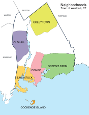
- Saugatuck – around the Westport railroad station near the southwestern corner of the town – a built-up area with some restaurants, stores and offices. Saugatuck originates from the Paugussett tribe meaning mouth of the tidal river.
- Saugatuck Shores – A curved peninsula surrounded by the Long Island Sound, this area was once part of the town of Norwalk. Today several hundred residents live on the peninsula, which became part of Westport in the 1960s.
- Saugatuck Island – founded in the 1890s as Greater Marsh Shores, the island was renamed to its current name in 1920 and became a special taxing district on November 5, 1984.
- Downtown Westport - The area around Post Road and Main Street on and near the Saugatuck River that serves as the center of Westport, with many shops and restaurants. The downtown stores include many well-known brands including J. Crew, Eileen Fisher, Theory, Pottery Barn, West Elm, Lulu Lemon and more.There has been recent growth in the downtown area, including Levitt Pavilion, National Hall (The area where Post and Riverside intersect), and Bedford square (opening in 2017), a mixed use development on Church St, Elm St, Main St and Post Rd that will have apartments, public spaces, including a courtyard, underground parking, stores, and restaurants, as well as the incorporation of the historic Bedford Mansion.[32]
- Greens Farms – is Westport's oldest neighborhood starting around Hillspoint road and ending at Westport's boundary on the east side.[9] Greens Farms has its own Post Office[33] and train station.[34]
- Cockenoe Island (pronounced "KuhKEEnee") – just off the southeastern coast of the town. Cockenoe Island is an uninhabited island that was purchased by Westport for $212,740 from the United Illuminating Company in 1969 so that the company could not use the land to build a nuclear plant.[9]
- Old Hill – west of the Saugatuck River and north of the Post Road, a historic section of town with many homes from the Revolutionary and Victorian eras. Prior to the road being called the Boston Post Road it was called the Connecticut Turnpike.[35]
- Coleytown – Located at the northern edge of town, near the Weston town line. Home to Coleytown fire station, Middle and Elementary school. Named for Farmer Coley, who owned lots of land in this area.
- Cro-No - The Cross Highway/North Avenue boundary surrounding both Staples High School and Bedford Middle School.
- Compo – Located around the main beach in the town, Compo Beach. Compo (Compaug), can be traced back to the early Paugussett tribe and means the bear's fishing ground.[36]
- SewTrol - The area containing the Town Sewage Treatment Plant, the Town Animal Control, and the State Boat Launch.

Demographics
| Historical population | |||
|---|---|---|---|
| Census | Pop. | %± | |
| 1840 | 1,803 | — | |
| 1850 | 2,651 | 47.0% | |
| 1860 | 3,293 | 24.2% | |
| 1870 | 3,361 | 2.1% | |
| 1880 | 3,477 | 3.5% | |
| 1890 | 3,715 | 6.8% | |
| 1900 | 4,017 | 8.1% | |
| 1910 | 4,259 | 6.0% | |
| 1920 | 5,114 | 20.1% | |
| 1930 | 6,073 | 18.8% | |
| 1940 | 8,258 | 36.0% | |
| 1950 | 11,667 | 41.3% | |
| 1960 | 20,955 | 79.6% | |
| 1970 | 27,318 | 30.4% | |
| 1980 | 25,290 | −7.4% | |
| 1990 | 24,410 | −3.5% | |
| 2000 | 25,749 | 5.5% | |
| 2010 | 26,391 | 2.5% | |
| Est. 2017 | 27,777 | 5.3% | |
| CT.gov | |||
The 2010 US Census counted the total number of households in Westport being 9,573 of which 7,233 (75.6%) were family households.[37] The population density was 1,322.2 inhabitants per square mile (510.5/km2). There were 10,065 housing units at an average density of 503.0 per square mile (194.2/km²).
According to the 2010 Census, the population of Westport was 92.6% White, 4.0% Asian, 1.2% Black or African American, and 0.1% American Indian. Individuals from other races made up 0.6% of Westport's population while individuals from two or more races made up 1.6%.[38] In addition, Hispanics of any race made up 3.5% of Westport's population. About 29.8% of Westport residents were younger than age 18 as of 2010; higher than the U.S. average of 24%.
According to the 2000 Census, there were 9,586 households, of which 38.4% had children under the age of 18 living with them, 66.1% were married couples living together, 6.8% have a woman whose husband does not live with her, and 25.2% were non-families. 20.8% of all households were made up of individuals and 8.8% had someone living alone who was 65 years of age or older. The average household size was 2.66 and the average family size was 3.10.
In the town, the population was spread out with 27.9% under the age of 18, 2.7% from 18 to 24, 26.2% from 25 to 44, 28.0% from 45 to 64, and 15.1% who were 65 years of age or older. The median age was 41 years. For every 100 females, there were 90.7 males. For every 100 females age 18 and over, there were 86.3 males.
According to a 2007 estimate, the median income for a household in the town was $147,391, and the median income for a family was $176,740. As of the 2000 Census, males had a median income of $100,000 versus $53,269 for females. The per capita income for the town was $73,664. 2.6% of the population and 1.5% of families were below the poverty line. Out of the total people living in poverty, 2.7% are under the age of 18 and 2.1% are 65 or older.
In July 2008, Westport was named the fifth top-earning city in the US, with a median family income of $193,540 and median home price of $1,200,000.[39] In 2018, data from the American Community Survey revealed that Westport was the 9th wealthiest city in the United States.[40]
Government
| Year | Democratic | Republican | Third Parties |
|---|---|---|---|
| 2016 | 68.99% 10,655 | 26.99% 4,169 | 4.01% 620 |
| 2012 | 56.45% 8,495 | 42.79% 6,439 | 0.76% 114 |
| 2008 | 65.05% 10,067 | 34.52% 5,342 | 0.43% 66 |
| 2004 | 59.47% 9,115 | 39.56% 6,063 | 0.98% 150 |
| 2000 | 57.35% 8,304 | 38.61% 5,590 | 4.05% 586 |
| 1996 | 51.61% 7,331 | 40.73% 5,785 | 7.67% 1,089 |
| 1992 | 48.10% 7,799 | 38.02% 6,166 | 13.88% 2,251 |
| 1988 | 44.32% 6,519 | 54.73% 8,051 | 0.95% 140 |
| 1984 | 38.58% 5,774 | 61.21% 9,162 | 0.21% 31 |
| 1980 | 30.26% 4,381 | 53.95% 7,810 | 15.79% 2,285 |
| 1976 | 40.97% 6,053 | 58.73% 8,677 | 0.30% 44 |
| 1972 | 40.23% 5,937 | 58.98% 8,705 | 0.79% 116 |
| 1968 | 42.34% 5,435 | 54.82% 7,037 | 2.84% 365 |
| 1964 | 59.54% 6,939 | 40.46% 4,716 | 0.00% 0 |
| 1960 | 35.86% 3,825 | 64.14% 6,842 | 0.00% 0 |
| 1956 | 24.60% 2,232 | 75.40% 6,842 | 0.00% 0 |
Westport, like Connecticut as a whole, is heavily Democratic. Hillary Rodham Clinton outscored Donald J. Trump by 42 points in 2016, marking the best performance for a Democratic presidential nominee in the town in over 60 years.
Westport was one of five towns in Connecticut that backed former Governor John Kasich over Donald J. Trump in the 2016 Republican presidential primary. Kasich received 1,098 votes (46.19 percent) ahead of Trump who garnered 1,053 votes (44.30 percent). U.S. Senator Ted Cruz of Texas finished third with 165 votes (6.94 percent).[42]
The town switched to a Representative Town Meeting style governance in 1949. The government consists of a three-member Board of Selectmen, a Representative Town Meeting (RTM), a Board of Finance, a Board of Education, a Planning and Zoning Commission, and various other commissions, boards, and committees.
Taxes
As of 2019, the current mill rate of Westport is 16.86.[43]
Fire department
The town of Westport is protected by the paid, full-time firefighters of the Westport Fire Department (WFD). Established in 1929, the Westport Fire Department currently operates out of 4 fire stations, located throughout the town, and maintains a fire apparatus fleet of 6 Engines, (4 first line and 2 reserve) 1 truck, 1 rescue, 1 fireboat, 1 High Water Unit, 1 utility unit and 1 Shift Commander's unit. The fire department also holds the Fairfield County Hazardous Materials Truck, housed at Westport Fire Headquarters. The Westport Fire Department responds to, on average, approximately 4,000 emergency calls annually.[44]
Below is a complete listing of all fire station locations and apparatus in the town of Westport.
| Engine company | Special unit | Address | Neighborhood |
|---|---|---|---|
| Engine 2 | Rescue 3, Fireboat, High Water Unit, Utility Unit | 515 Post Rd. E. | Downtown |
| Engine 4 | 555 Riverside Ave. | Saugatuck | |
| Engine 5 | 66 Center St. | Greens Farms | |
| Engine 6 | FireBoat | 61 Easton Rd. | Coleytown |
Education
Schools
Public schools

Staples High School is Westport's only public high school. The Patch.com reports that "Staples High School was ranked No. 14 for best public high schools in Connecticut and 574th best nationwide."[45]
The district has two middle schools, Bedford Middle School and Coleytown Middle School, the latter being down for renovations.[46] In September 2009, Bedford Middle School was awarded the government-honored Blue Ribbon Award. In 2011, Out of 298 middle schools, Coleytown Middle and Bedford Middle schools were ranked No. 1 and No. 2 in the state, respectively.[47]
There are five elementary schools with a total of 2,556 students:
- Coleytown Elementary School[48]
- King's Highway Elementary School[49]
- Green's Farms Elementary School[50]
- Saugatuck Elementary School[51]
- Long Lots Elementary School[52]
There are numerous preschools in Westport, including Stepping Stones Pre-school, Greens Farms Nursery School, Saugatuck Nursery School, Earthplace Nursery School and the YMCA Childcare.[53][54][55][56]
For the 2009–10 fiscal year, the school district's adopted budget is $110.6 million.[57] The school district had an estimated $109.1 million budget for the 2009–10 fiscal year, giving it an average per pupil expenditure of $16,266.[58] The average 2010 class size for kindergarten through first grade was 22 students and 25 students for second through fifth grade.[59]
Private schools
Greens Farms Academy, located in the 1920s Vanderbilt estate overlooking Long Island Sound, is a K-12 private preparatory school located in the Greens Farms section of town. Pierrepont School, opened in 2002 on Sylvan Road, is a private K-12 school for gifted students.

Scientific institutions
The Rolnick Observatory, operated by the Westport Astronomical Society, is open to the public for free on clear Wednesday and Thursday evenings. The observatory is located at 182 Bayberry Lane, on a former Nike missile site.[60][61]
Earthplace, The Nature Discovery Center, is a natural history museum, nature center and wildlife sanctuary located at 10 Woodside Lane. The organization is dedicated to the promotion of public environmental education, preservation and conservation. Activities include maintaining a 62-acre (250,000 m2) open space wildlife sanctuary with trails, presenting public nature education programs, a water quality monitoring program, an interactive nature discovery area, a nursery school and summer camp.
Media
Westport's first newspaper dates back to the printing and publication of the first issue of The Saugatuck Journal on December 26, 1828.[19][62]
Westport is served by both English-language newspapers and news websites including Westport News[63] and WestportNow.[64] The town is also home to a monthly magazine Westport.
Economy
Commerce and industry
The financial services sector employs 7,171 in Westport; half of whom commute daily to Westport.[27] The financial services industry is a major segment of the local economy. The major financial services companies in Westport now are Bridgewater Associates, a global investment manager and Westport's largest employer, Canaan Partners, an early stage venture capital firm focusing on IT and life sciences, and BNY Mellon.[65] Professional, scientific, and technical services companies include Terex, a Fortune 500 company manufacturing industrial equipment and offering professional and technical services around those products, and dLife, a multimedia diabetes education (and marketing) company.
Nonprofits
- The Westport Country Playhouse, founded in 1930, is a regional theater known for its excellent theatrical performances.[66] After Paul Newman moved to Westport in 1960, he became a principal "driving force" behind the playhouse reported as "one the country’s most respected summer theaters."[66] The playhouse went through a renovation process that was completed in 2005 on its seventy-fifth anniversary.[8][10]
- Save the Children, the American charity, governed entirely separately from the British charity of the same name, was headquartered in Westport before moving to Fairfield.[8][67]
- The Smith Richardson Foundation, a public policy think tank, is headquartered in Westport, Connecticut.
- The Westport Animal Shelter Advocates (WASA) support the town's animal shelter located on Elaine Road, as well as other Fairfield County animal shelters.
Attractions
Parks and recreation
Comprising 234 acres (0.95 km2), Sherwood Island State Park is located on Long Island Sound and includes beach access. Compo Beach and Burying Hill Beach are municipal beaches that are open to out-of-town visitors in the summer for a fee. The state's 9/11 memorial was put in Sherwood Island State Park in Westport; on a clear day the New York City skyline can be seen.[68]
In 1960, Westport purchased Longshore Club Park.
In 2011, Paul Newman's estate gave land to Westport to be managed by the Aspetuck Land Trust.[69]
In 2010, the historic Wakeman Farm was reopened to the public as the Wakeman Town Farm and Sustainability Center. The town's website describes as an "organic demonstration homestead open to the public. The Farm is a model facility created to educate the community with local healthy food production, responsible land stewardship, sustainable practices and community service orientation."[70]

Transportation
Interstate 95, the Merritt Parkway, and U.S. 1, as well as the Saugatuck River, run through Westport.
Westport has two train stations, Green's Farms and Westport on the Metro-North Railroad's New Haven Line, which serves Stamford and Grand Central Terminal in New York City or New Haven-Union Station. This line is shared with Amtrak trains as it is part of the Northeast Corridor, but no Amtrak services stop at Green's Farms or Westport. The nearest Amtrak stations are at Bridgeport (10 miles) and Stamford (12 miles).
"Main to Train" Study
A recent initiative by residents of the Town of Westport, Connecticut. It is part of a greater interest to improve pedestrian and cyclist options from the major places of interest in town: downtown Westport to the Westport Train Station. This approximate two-mile stretch of road is most directly accessible via Post Road East (U.S. Route 1) to Riverside Avenue. The third iteration of the study will more specifically address ways in which this path can be improved for people not travelling by car; the first report considered the conditional state of the path and the second analyzed traffic conditions.
The Westport Planning and Zoning Commission is interested in offering more sustainable and accessible transit options: in 2017 the Commission released a report on alternate transit options,[71] complete with surveys of town residents and maps of current sidewalks and bike paths. The lack of sidewalks on some two-way arterial and many collector streets may increase the potential for accidents. This is occurring in tandem with the Connecticut Department of Transportation’s notable laws which support users of all transit forms: the Complete Streets Law of 2009,[72] the 2014 Vulnerable User Law,[73] and the 2015 Bike Bill.[74] A true application of change in the post-Complete Streets law is the restriping of road shoulders by the DOT across the state, including the many, already narrow, two-way streets. The narrowing of roads[75] is known to encourage slower, safer driving, which protects pedestrians and cyclists, as well as auto users. This form of traffic calming is thus in line with Vision Zero, an interest by New Urbanists and city planners focused on reducing traffic-caused injuries and fatalities.
The Norwalk Transit District, with several routes available for Westporters due to support by the Town of Westport, offers another form of transit for mainly commuting use.
In popular culture
- Westport was the location of the fictional residence (1164 Morning Glory Circle) of Darrin and Samantha Stephens on the television series Bewitched.[76]
- In the sixth and final season of I Love Lucy, the Ricardos and Mertzes leave New York and move to Westport.
- The Twilight Zone had one episode called "A Stop at Willoughby", wherein the main character worked in NYC and commuted by train to his home in Westport.[77] It aired on May 6, 1960, and the episode was written by then-Westport resident Rod Serling.
- The Swimmer (1968), a film starring Burt Lancaster, is based on a short story by John Cheever. Most of the film was shot in backyard pool locations in Westport.[78]
- The Stepford Wives (1975) filmed in various Westport locations and used a colonial house in the Williamsburg district as the home of the main characters.[79]
- Don DeLillo's Underworld (1997) features an ad executive named Charlie Wainwright who in 1961 lives in Westport.[80]
- The 1998 production This Is My Father was partly filmed in Westport.[81]
- The 2004 film The Girl Next Door was vaguely based on Westport – director Luke Greenfield grew up in town. It was filmed and set in California. That same decade parts of the 2008 production of The Sisterhood of the Traveling Pants 2 were filmed in Westport[82]
- American Housewife takes place in Westport.[83]
Notable people
Among the many actors, singers and other entertainers who have lived in town is Paul Newman who resided in Westport from 1960 until his death in 2008. His wife, Joanne Woodward, still resides in town.[84][85] Fala (1940–1952), President Franklin D. Roosevelt's dog, was an early Christmas gift from Mrs. Augustus G. Kellogg, a town resident.[86] Actress Gene Tierney grew up in Greens Farms.[87] Martha Stewart also lived in Westport at her historic estate of Turkey Hill.[88] Jean Donovan, a lay Roman Catholic missioner martyred in El Salvador in 1980 grew up in Westport and graduated from Staples High School. She is honored on the litany of saints by the Lutheran World Federation and by The Anglican Communion. Academy Award winner Sandy Dennis lived in Westport until her death in 1992. Actor Christopher Walken lives in Westport.
Sister cities
As of 2020, Westport has three sister cities:[89]


References
- "Board of Selectmen". Town of Westport, Connecticut. Retrieved September 16, 2015.
- "QuickFacts: Westport CDP, Connecticut". United States Census Bureau. U.S. Department of Commerce. Retrieved June 24, 2017.
- "2010 Census Interactive Population Search". United State Census 2010. U.S. Census Bureau. Archived from the original on May 27, 2016. Retrieved July 13, 2017.
- "QuickFacts, Westport CDP, Connecticut". United States Census Bureau. U.S. Department of Commerce. Retrieved July 13, 2017.
- Hagan, Shelly (March 5, 2018). "America's 100 Richest Places". United States: Bloomberg.com. Bloomberg L.P. Retrieved April 23, 2019.
- "Race, Hispanic or Latino, Age, and Housing Occupancy: 2010 Census Redistricting Data (Public Law 94-171) Summary File (QT-PL), Westport town, Connecticut". United States Census Bureau. Retrieved August 11, 2011.
- Sherman, Lauren (December 9, 2008). "In Depth: Twenty Most Affluent U.S. Neighborhoods". Forbes. Retrieved November 14, 2011.
- Woody Klein; Westport Historical Society (Conn.) (May 2000). Westport, Connecticut: the story of a New England town's rise to prominence. Greenwood Press. pp. 1–15. ISBN 978-0-313-31126-0. Retrieved November 21, 2011.
- Prevost, Lisa (January 7, 2001). "If You're Thinking of Living In/Green's Farms; A Country Atmosphere Near the Sound". New York Times. Retrieved November 30, 2011.
- Richard Somerset-Ward (June 11, 2005). An American theatre: the story of Westport Country Playhouse, 1931–2005. Yale University Press. pp. 29, 237. ISBN 978-0-300-10648-0. Retrieved November 17, 2011.
- Jennings. p. 148. Missing or empty
|title=(help) - R. H. Howard; Henry E. Crocker (1879). A history of New England: containing historical and descriptive sketches of the counties, cities and principal towns of the six New England states, including, in its list of contributors, more than sixty literary men and women, representing every county in New England. Crocker & co. p. 302. Retrieved November 28, 2011.
- Mark Mayo Boatner (1975). Landmarks of the American Revolution: a guide to locating and knowing what happened at the sites of independence. Hawthorn Books. pp. 45–47. Retrieved November 13, 2011.
- Colley, Brent. "April 26, 1777 British Raid on Danbury, Connecticut". My Brother Sam is Dead. Retrieved November 20, 2019.
- Connecticut State Library (1909). Bulletin. p. 50. Retrieved November 20, 2011.
- Woody Klein; Westport Historical Society (Conn.) (May 2000). Westport, Connecticut: the story of a New England town's rise to prominence. Greenwood Press. pp. 85–108. ISBN 978-0-313-31126-0. Retrieved November 21, 2011.
- James Jay Mapes (1853). Working farmer. Kingman & Cross. Retrieved November 21, 2011.
- Time Inc (August 8, 1949). LIFE. Time Inc. p. 74. ISSN 0024-3019. Retrieved December 12, 2011.
- Woody Klein; Westport Historical Society (Conn.) (May 2000). Westport, Connecticut: the story of a New England town's rise to prominence. Greenwood Press. pp. 119–146. ISBN 978-0-313-31126-0. Retrieved November 29, 2011.
- United States. Congress (1871). Congressional edition. U.S. G.P.O. pp. 256–. Retrieved December 12, 2011.
- Lauraleigh O'Meara (August 2, 2002). Lost city: Fitzgerald's New York. Psychology Press. p. 34. ISBN 978-0-415-94055-9. Retrieved December 12, 2011.
- Woody Klein; Westport Historical Society (Conn.) (May 2000). Westport, Connecticut: the story of a New England town's rise to prominence. Greenwood Press. pp. 233–262. ISBN 978-0-313-31126-0. Retrieved November 27, 2011.
- Powell, Mike (2007). "Westport, Conn., Buying Guide". New York Times. Retrieved December 12, 2011.
- Ann Kerns (October 24, 2006). Martha Stewart. Twenty-First Century Books. p. 45. ISBN 978-0-8225-6613-7. Retrieved December 12, 2011.
- James G. Gimpel; Jason E. Schuknecht (June 14, 2004). Patchwork Nation: Sectionalism and Political Change in American Politics. University of Michigan Press. pp. 217–. ISBN 978-0-472-03030-9. Retrieved December 12, 2011.
- Michael N. Danielson; Jameson W. Doig (October 3, 1983). New York: The Politics of Urban Regional Development. University of California Press. pp. 151–. ISBN 978-0-520-04551-4. Retrieved December 12, 2011.
- "Westport, Connecticut (CT) profile". Retrieved December 6, 2011.
- "Connecticut: 2010 Population and Housing Unit Counts 2010 Census of Population and Housing" (PDF). United States Census 2010. U.S. Department of Commerce. Retrieved July 13, 2017.
- "Westport, CT (06880) Monthly Weather". weather.com. TWC Product and Technology LLC. Retrieved April 23, 2019.
- "Historical Weather Westport, CT Weather". Retrieved December 7, 2011.
- "Flood Map". Town of Westport. Retrieved November 20, 2019.
- "Home". Bedford Square.
- "Post Office in Greens Farms, CT - Hours and Location". www.postallocations.com.
- "MNR Stations". as0.mta.info.
- Woody Klein; Westport Historical Society (Conn.) (May 2000). Westport, Connecticut: the story of a New England town's rise to prominence. Greenwood Press. p. 96. ISBN 978-0-313-31126-0. Retrieved November 30, 2011.
- Woody Klein; Westport Historical Society (Conn.) (May 2000). Westport, Connecticut: the story of a New England town's rise to prominence. Greenwood Press. pp. 16–29. ISBN 978-0-313-31126-0. Retrieved December 18, 2011.
- "Households and Families: 2010 Census Summary". United States Census Bureau. U.S. Department of Commerce. Retrieved July 13, 2017.
- "Profile of General Population and Housing Characteristics: 2010". U.S. Census Bureau. Retrieved November 14, 2011.
- "25 top-earning towns". CNN. August 7, 2008. Retrieved November 21, 2011.
- "The 10 wealthiest cities in the United States". Tribune Media.
- https://authoring.ct.gov//SOTS/Election-Services/Statement-Of-Vote-PDFs/General-Elections-Statement-of-Vote-1922
- https://portal.ct.gov/-/media/SOTS/ElectionServices/StatementOfVote_PDFs/April2016RepublicanPPPSOVpdf.pdf?la=en
- "FY 2020 Mill Rates" (PDF). State of Connecticut. November 10, 2019. Retrieved November 21, 2019.
- Town of Westport, CT : Fire Department. Westportct.gov (August 17, 2012). Retrieved on August 16, 2013.
- "Staples High School". U.S. News. Retrieved February 4, 2020.
- Vaughan, Sophie (October 16, 2018). "Westport school to remain closed after mold problems grow". Westport News. Retrieved November 20, 2019.
- Inzitari, Vanessa. "Westport School District Tops State Rankings". The Westport Daily Voice. Retrieved July 26, 2012.
- "Coleytown Elementary School". Archived from the original on January 23, 2001. Retrieved July 3, 2006.
- "King's Highway Elementary School". Archived from the original on October 23, 2007. Retrieved November 1, 2007.
- "Green's Farms Elementary School". Archived from the original on July 24, 2011. Retrieved December 28, 2008.
- "Saugatuck Elementary School". Archived from the original on August 15, 2011. Retrieved December 28, 2008.
- "Long Lots Elementary School". Archived from the original on July 24, 2011. Retrieved December 28, 2008.
- "Around Our Towns". Minuteman News Center. November 2, 2011. Retrieved November 23, 2011.
- Kent Garland Burtt (November 1984). Smart times: a parent's guide to quality time with preschoolers. Harper & Row. p. xii. ISBN 978-0-06-015287-1. Retrieved November 23, 2011.
- Directory of Child Day Care Centers: Northeast. Oryx Press. January 1, 1986. pp. 371–. ISBN 978-0-89774-256-6. Retrieved November 23, 2011.
- Lang, Kirk (November 3, 2011). "Saugatuck Nursery grows to keep up with youngsters". Westport News. Retrieved November 23, 2011.
- WestportCT.gov Archived July 2, 2010, at the Wayback Machine Westport 2010–2011 Fiscal Year Budget
- Westport School District Archived July 12, 2010, at the Wayback Machine General information about the district incl. number of enrolled students
- Lomuscio, James (September 1, 2010). "Opening Day for Schools Called a 'Great Kickoff'". WestportNow.com. Retrieved November 12, 2011.
- Philip S. Harrington (November 30, 2010). Cosmic Challenge: The Ultimate Observing List for Amateurs. Cambridge University Press. pp. 10–. ISBN 978-0-521-89936-9. Retrieved December 12, 2011.
- Astronomy. AstroMedia Corp. 1982. Retrieved December 12, 2011.
- Woody Klein; Westport Historical Society (Conn.) (May 2000). Westport, Connecticut: the story of a New England town's rise to prominence. Greenwood Press. pp. 65–82. ISBN 978-0-313-31126-0. Retrieved November 21, 2011.
- WestportNow.com., Free weeklies the Westport Minuteman and the Fairfield Minuteman (Connecticut) ceased publication in late October, according to. "Connecticut weeklies close".
- "WestportNow.com - Westport, Connecticut's 24-hours News and Information Source". westportnow.com.
- "Bridgewater, Town's Largest Employer, Could Be Leaving". WestportNow. July 9, 2010. Retrieved November 13, 2011.
- Morris, Stacey (June 13, 2010). "Westport: The Beverly Hills of the East". The Jerusalem Post. Retrieved November 21, 2011.
- Woody Klein; Westport Historical Society (Conn.) (May 2000). Westport, Connecticut: the story of a New England town's rise to prominence. Greenwood Press. pp. 181–204. ISBN 978-0-313-31126-0. Retrieved November 28, 2011.
- Barnett D. Laschever; Andi Marie Cantele; Kim Grant (May 18, 2009). Explorer's Guide Connecticut. The Countryman Press. pp. 88–. ISBN 978-0-88150-824-6. Retrieved November 28, 2011.
- Hennessy, Christina (October 20, 2011). "Sightseeing: Newman Poses Nature Preserve may have marquee name, but nature is the star". The Stamford Advocate, Conn. Retrieved September 16, 2012.
- Llewellyn, Eliza (September 24, 2010). "The Vine is Cut, Wakeman Town Farm Opens". Inklings News, Conn. Retrieved August 9, 2015.
- "ENHANCE PEDESTRIAN, BICYCLE AND TRANSIT OPTIONS". Town of Westport.
- "Substitute Senate Bill No. 735: Public Act No. 09-154: AN ACT IMPROVING BICYCLE AND PEDESTRIAN ACCESS". www.cga.ct.gov. June 30, 2009. Retrieved November 5, 2019.
- "Senate Bill No. 336: Public Act No. 14-31: AN ACT CONCERNING THE PENALTY FOR CAUSING HARM TO A VULNERABLE USER OF A PUBLIC WAY" (PDF). www.cga.ct.gov. May 16, 2014. Retrieved November 5, 2019.
- "Substitute Senate Bill No. 502: Public Act No. 15-41: AN ACT CONCERNING BICYCLE SAFETY" (PDF). www.cga.ct.gov. June 15, 2015. Retrieved November 5, 2019.
- "Traffic Calming to Slow Vehicle Speeds". US Department of Transportation. August 24, 2015. Retrieved November 5, 2019.
- Vincent Terrace (October 1993). Television character and story facts: over 110,000 details from 1,008 shows, 1945–1992. McFarland & Co. p. 46. ISBN 978-0-89950-891-7. Retrieved November 13, 2011.
- Leslie Dale Feldman (November 30, 2010). Spaceships and Politics: The Political Theory of Rod Serling. Lexington Books. pp. 91–92. ISBN 978-0-7391-2045-3. Retrieved November 13, 2011.
- Donovan, Elisabeth (June 24, 1990). "Just Pooling Around". The Miami Herald.
- Charles, Eleanor (April 21, 1985). "Connecticut Guide". New York Times (National edition). United States. The New York Times Company. p. CN11. Retrieved May 2, 2019.
- Don DeLillo, Underworld (New York: Scribner's (1997), pp. 526-35.
- Irène Bessière; Roger Odin (2004). Les européens dans le cinéma américain: émigration et exil. Presses Sorbonne Nouvelle. p. 217. ISBN 978-2-87854-261-5. Retrieved November 14, 2011.
- Meyers, Joe (September 10, 2008). "Major movies filmed scenes in Conn". Connecticut Post Online. "The recent Warner Bros. release "The Sisterhood of the Traveling Pants 2" features parts of Bridgeport standing in for Providence, R.I. and Manhattan; the Westport Country Playhouse is passed off as a Vermont summer stock theater; and WestConn in Danbury fills in for the Rhode Island School of Design."
- Genzlinger, Neil (October 10, 2016). "Review: In 'American Housewife,' a Plus-Size Mom in the Land of Fitbits". New York Times (Television). United States. The New York Times Company. p. C6. Retrieved May 3, 2019.
- Harmetz, Aljean (September 28, 2008). "Paul Newman, a Magnetic Titan of Hollywood, Is Dead at 83". The New York Times. Retrieved April 6, 2010.
- The Encyclopedia of New York City Second Edition. Yale University Press. December 1, 2010. pp. 3240–. ISBN 978-0-300-18257-6. Retrieved December 12, 2011.
- Derr, Mark (September 15, 2005). A Dog's History of America: How Our Best Friend Explored, Conquered, and Settled a Continent. Macmillan. p. 305. ISBN 978-0-374-52997-0. Retrieved November 12, 2011.
- Time Inc. (February 19, 1940). LIFE. Time Inc. p. 35. ISSN 0024-3019. Retrieved November 12, 2011.
- Price, Joann F. (June 2007). Martha Stewart: a biography. Greenwood Publishing Group. p. 33. ISBN 978-0-313-33893-9. Retrieved November 12, 2011.
- "Town of Westport, CT : Sister Cities Committee". westportct.gov.
External links
| Wikimedia Commons has media related to Westport, Connecticut. |
| Wikivoyage has a travel guide for Westport, Connecticut. |
Municipalities and communities of Fairfield County, Connecticut, United States | ||
|---|---|---|
| Cities |
|  |
| Towns | ||
| Borough |
| |
| CDPs | ||
| Other communities |
| |
| Ghost town |
| |
| Indian reservation |
| |
| Footnotes | ‡This populated place also has portions in an adjacent county or counties | |
Hartford (capital) | ||
| Topics |
|  |
| Society |
| |
| Regions |
| |
| Counties |
| |
| Cities |
| |
| All Towns |
| |
| Places |
| |
New York metropolitan area | ||
|---|---|---|
| Counties |  | |
| Major cities | ||
| Cities and towns over 100,000 |
| |
| Cities and towns over 25,000 |
| |
| Cities and towns over 10,000 |
| |
| Regions |
| |
| Topics |
| ||||||
|---|---|---|---|---|---|---|---|
| States | |||||||
| Major cities |
| ||||||
| State capitals | |||||||
| Transportation |
| ||||||
| |||||||
| Authority control |
|
|---|