Concord, New Hampshire
Concord (/ˈkɒŋkərd/) is the capital city of the U.S. state of New Hampshire and the county seat of Merrimack County. As of the 2010 census, its population was 42,695,[6] and in 2018 the population was an estimated 43,412.[4]
Concord, New Hampshire | |
|---|---|
State capital and city | |
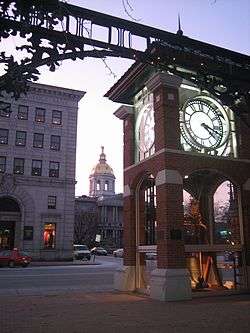 The New Hampshire State House as seen from Eagle Square | |
 Flag  Seal | |
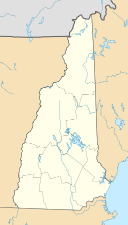
 Location in Merrimack County, New Hampshire | |
 Concord  Concord Concord (the United States)  Concord Concord (North America) | |
| Coordinates: 43°12′24″N 71°32′17″W | |
| Country | |
| State | |
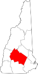
| County | Merrimack |
| Region | New England |
| Settled | 1659[1] |
| Incorporated | 1733[2] |
| Government | |
| • Type | mayor–council |
| • Mayor | Jim Bouley |
| • City Council | Members
|
| • City Manager | Thomas J. Aspell, Jr. |
| Area | |
| • Total | 67.19 sq mi (174.0 km2) |
| • Land | 63.95 sq mi (165.6 km2) |
| • Water | 3.24 sq mi (8.4 km2) |
| Elevation | 288 ft (88 m) |
| Population | |
| • Total | 42,695 |
| • Estimate (2018)[4] | 43,412 |
| • Density | 678.8/sq mi (262.1/km2) |
| • μSA | 151,391[5] |
| Time zone | UTC−5 (Eastern) |
| • Summer (DST) | UTC−4 (Eastern) |
| ZIP Codes | 03301, 03302, 03303, 03305 |
| Area code(s) | 603 |
| FIPS code | 33-14200 |
| GNIS feature ID | 873303 |
| Primary Airports | Concord Municipal Airport |
| Interstates | |
| Bus service | CAT, Concord Coach Lines |
| Website | www |
The village of Penacook, where Concord was initially settled, lies at the northern boundary of the city limits. The city is home to the University of New Hampshire School of Law, New Hampshire's only law school; St. Paul's School, a private preparatory school; NHTI, a two-year community college; the New Hampshire Police Academy; and the New Hampshire Fire Academy. It is the resting place of Franklin Pierce, 14th President of the United States.[7]
History
The area that would become Concord was originally settled thousands of years ago by Abenaki Native Americans called the Pennacook.[8]:65 The tribe fished for migrating salmon, sturgeon, and alewives with nets strung across the rapids of the Merrimack River. The stream was also the transportation route for their birch bark canoes, which could travel from Lake Winnipesaukee to the Atlantic Ocean. The broad sweep of the Merrimack River valley floodplain provided good soil for farming beans, gourds, pumpkins, melons and maize.
The area was first settled in 1659 as "Penacook".[9] On January 17, 1725, the Province of Massachusetts Bay, which then claimed territories west of the Merrimack River, granted the Concord area as the Plantation of Penacook.[8]:107 It was settled between 1725 and 1727 by Captain Ebenezer Eastman and others from Haverhill, Massachusetts. On February 9, 1734, the town was incorporated as "Rumford",[8]:147 from which Sir Benjamin Thompson, Count Rumford would take his title. It was renamed "Concord" in 1765 by Governor Benning Wentworth following a bitter boundary dispute between Rumford and the town of Bow; the city name was meant to reflect the new concord, or harmony, between the disputant towns.[10] Citizens displaced by the resulting border adjustment were given land elsewhere as compensation. In 1779, New Pennacook Plantation was granted to Timothy Walker, Jr. and his associates at what would be incorporated in 1800 as Rumford, Maine, the site of Pennacook Falls.
Concord grew in prominence throughout the 18th century, and some of its earliest houses survive at the northern end of Main Street.[11] In the years following the Revolution, Concord's central geographical location made it a logical choice for the state capital, particularly after Samuel Blodget in 1807 opened a canal and lock system to allow vessels passage around the Amoskeag Falls downriver, connecting Concord with Boston by way of the Middlesex Canal. In 1808, Concord was named the official seat of state government.[8]:324–326 The 1819 State House is the oldest capitol in the nation in which the state's legislative branches meet in their original chambers. The city would become noted for furniture-making and granite quarrying. In 1828, Lewis Downing joined J. Stephens Abbot to form Abbot and Downing.[8]:339–340 Their most famous product was their Concord coach, widely used in the development of the American West. In the 19th century, Concord became a hub for the railroad industry, with Penacook a textile manufacturing center using water power from the Contoocook River. Today, the city is a center for health care and several insurance companies.
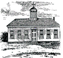
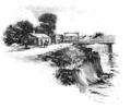 First Concord Bridge, 1795
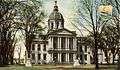 State House c. 1906
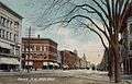 Main Street c. 1908
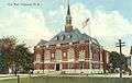 City Hall in 1913
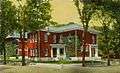 Old Library c. 1915
Geography
Concord is located at 43°12′24″N 71°32′17″W (43.2070, −71.5371).[12]
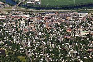
According to the United States Census Bureau, the city has a total area of 67.5 square miles (174.8 km2). 64.2 square miles (166.4 km2) of it is land and 3.2 square miles (8.4 km2) of it is water, comprising 4.79% of the city.[6] Concord is drained by the Merrimack River. Penacook Lake is in the west. The highest point in Concord is 860 feet (260 m) above sea level on Oak Hill, just west of the hill's 970-foot (300 m) summit in neighboring Loudon.
Concord lies fully within the Merrimack River watershed,[13] and is centered on the river, which runs from northwest to southeast through the city. Downtown is located on a low terrace to the west of the river, with residential neighborhoods climbing hills to the west and extending southwards towards the town of Bow. To the east of the Merrimack, atop a 100-foot (30 m) bluff, is a flat, sandy plain known as Concord Heights, which has seen most of the city's commercial development since 1960. The eastern boundary of Concord (with the town of Pembroke) is formed by the Soucook River, a tributary of the Merrimack. The Turkey River winds through the southwestern quarter of the city, passing through the campus of St. Paul's School before entering the Merrimack River in Bow. In the northern part of the city, the Contoocook River enters the Merrimack at the village of Penacook.
It is 16 miles (26 km) north of Manchester, New Hampshire's largest city, and 66 miles (106 km) north of Boston.
Villages
The City of Concord is split into distinct villages which residents identify with inside the boundaries of the city itself. These five villages are Penacook, the Concord Heights, East Concord, West Concord, and the downtown neighborhoods referred to as the North End and the South End.[14]
Adjacent municipalities
- Canterbury, New Hampshire (north)
- Loudon, New Hampshire (northeast)
- Pembroke, New Hampshire (southeast)
- Bow, New Hampshire (south)
- Hopkinton, New Hampshire (west)
- Webster, New Hampshire (northwest)
- Boscawen, New Hampshire (northwest)
Climate
Concord, as with much of New England, is within the humid continental climate zone (Köppen Dfb), with long, cold, snowy winters, very warm (and at times humid) summers, and relatively brief autumns and springs. In winter, successive storms deliver light to moderate snowfall amounts, contributing to the relatively reliable snow cover. In addition, lows reach at least 0 °F (−18 °C) on an average 15 nights per year, and the city straddles the border between USDA Hardiness Zone 5b and 6a.[15] However, thaws are frequent, with one to three days per month with 50 °F (10 °C)+ highs from December to February. Summer can bring stretches of humid conditions as well as thunderstorms, and there is an average of 12 days of 90 °F (32 °C)+ highs annually. The window for freezing temperatures on average begins on September 27 and expires on May 14.[16]
The monthly daily average temperature range from 20.6 °F (−6.3 °C) in January to 70.0 °F (21.1 °C) in July. Temperature extremes have ranged from −37 °F (−38 °C) in February 1943 to 102 °F (39 °C) in July 1966.
| Climate data for Concord Municipal Airport, New Hampshire (1981−2010 normals,[lower-alpha 1] extremes 1903–present)[lower-alpha 2] | |||||||||||||
|---|---|---|---|---|---|---|---|---|---|---|---|---|---|
| Month | Jan | Feb | Mar | Apr | May | Jun | Jul | Aug | Sep | Oct | Nov | Dec | Year |
| Record high °F (°C) | 72 (22) |
74 (23) |
89 (32) |
95 (35) |
98 (37) |
101 (38) |
102 (39) |
101 (38) |
98 (37) |
92 (33) |
80 (27) |
73 (23) |
102 (39) |
| Mean maximum °F (°C) | 50.8 (10.4) |
53.7 (12.1) |
66.6 (19.2) |
81.5 (27.5) |
88.7 (31.5) |
92.0 (33.3) |
93.1 (33.9) |
91.8 (33.2) |
87.7 (30.9) |
78.5 (25.8) |
68.7 (20.4) |
56.0 (13.3) |
95.5 (35.3) |
| Average high °F (°C) | 30.8 (−0.7) |
34.9 (1.6) |
43.8 (6.6) |
57.4 (14.1) |
68.9 (20.5) |
77.4 (25.2) |
82.3 (27.9) |
80.9 (27.2) |
72.6 (22.6) |
60.5 (15.8) |
48.4 (9.1) |
36.3 (2.4) |
58.0 (14.4) |
| Average low °F (°C) | 10.4 (−12.0) |
13.8 (−10.1) |
22.5 (−5.3) |
32.7 (0.4) |
42.6 (5.9) |
52.5 (11.4) |
57.7 (14.3) |
56.1 (13.4) |
47.4 (8.6) |
35.8 (2.1) |
28.2 (−2.1) |
17.2 (−8.2) |
34.8 (1.6) |
| Mean minimum °F (°C) | −11.2 (−24.0) |
−8.2 (−22.3) |
0.8 (−17.3) |
19.4 (−7.0) |
28.1 (−2.2) |
37.9 (3.3) |
45.4 (7.4) |
42.0 (5.6) |
31.8 (−0.1) |
21.2 (−6.0) |
11.1 (−11.6) |
−2.8 (−19.3) |
−14.6 (−25.9) |
| Record low °F (°C) | −35 (−37) |
−37 (−38) |
−20 (−29) |
4 (−16) |
21 (−6) |
30 (−1) |
35 (2) |
29 (−2) |
20 (−7) |
10 (−12) |
−17 (−27) |
−24 (−31) |
−37 (−38) |
| Average precipitation inches (mm) | 2.70 (69) |
2.62 (67) |
3.27 (83) |
3.41 (87) |
3.66 (93) |
3.69 (94) |
3.74 (95) |
3.18 (81) |
3.38 (86) |
4.04 (103) |
3.72 (94) |
3.20 (81) |
40.61 (1,033) |
| Average snowfall inches (cm) | 18.1 (46) |
12.3 (31) |
11.1 (28) |
2.8 (7.1) |
0 (0) |
0 (0) |
0 (0) |
0 (0) |
0 (0) |
trace | 2.6 (6.6) |
14.5 (37) |
61.4 (156) |
| Average precipitation days (≥ 0.01 in) | 10.8 | 9.5 | 11.5 | 11.8 | 12.4 | 12.7 | 10.9 | 9.8 | 9.3 | 10.1 | 11.2 | 10.9 | 130.9 |
| Average snowy days (≥ 0.1 in) | 8.2 | 6.5 | 5.3 | 1.2 | 0 | 0 | 0 | 0 | 0 | 0 | 1.9 | 6.6 | 29.7 |
| Average relative humidity (%) | 67.9 | 66.0 | 64.8 | 62.0 | 65.0 | 70.9 | 71.8 | 74.5 | 76.3 | 72.8 | 73.3 | 72.3 | 69.8 |
| Mean monthly sunshine hours | 162.8 | 171.8 | 210.5 | 223.2 | 258.4 | 274.3 | 295.8 | 261.9 | 214.7 | 183.4 | 127.8 | 134.8 | 2,519.4 |
| Percent possible sunshine | 56 | 58 | 57 | 56 | 57 | 60 | 64 | 61 | 57 | 54 | 44 | 48 | 56 |
| Average ultraviolet index | 1 | 2 | 4 | 5 | 7 | 8 | 8 | 7 | 6 | 3 | 2 | 1 | 5 |
| Source #1: NOAA (relative humidity and sun 1961–1990)[16][17][18] | |||||||||||||
| Source #2: Weather Atlas [19] (sunshine data) | |||||||||||||
Demographics
| Historical population | |||
|---|---|---|---|
| Census | Pop. | %± | |
| 1790 | 1,747 | — | |
| 1800 | 2,052 | 17.5% | |
| 1810 | 2,393 | 16.6% | |
| 1820 | 2,838 | 18.6% | |
| 1830 | 3,720 | 31.1% | |
| 1840 | 4,897 | 31.6% | |
| 1850 | 8,576 | 75.1% | |
| 1860 | 10,896 | 27.1% | |
| 1870 | 12,241 | 12.3% | |
| 1880 | 13,843 | 13.1% | |
| 1890 | 17,004 | 22.8% | |
| 1900 | 19,632 | 15.5% | |
| 1910 | 21,497 | 9.5% | |
| 1920 | 22,167 | 3.1% | |
| 1930 | 25,228 | 13.8% | |
| 1940 | 27,171 | 7.7% | |
| 1950 | 27,988 | 3.0% | |
| 1960 | 28,991 | 3.6% | |
| 1970 | 30,022 | 3.6% | |
| 1980 | 30,400 | 1.3% | |
| 1990 | 36,006 | 18.4% | |
| 2000 | 40,687 | 13.0% | |
| 2010 | 42,695 | 4.9% | |
| Est. 2018 | 43,412 | [4] | 1.7% |
| U.S. Decennial Census[20] | |||
As of the census of 2010, there were 42,695 people, 17,592 households, and 10,052 families residing in the city. The population density was 632.5 people per square mile (244.2/km²). There were 18,852 housing units at an average density of 293.2 per square mile (113.2/km²). The racial makeup of the city was 91.8% White, 2.2% Black or African American, 0.3% Native American, 3.4% Asian, 0.0% Pacific Islander, 0.4% from some other race, and 1.8% from two or more races. 2.1% of the population were Hispanic or Latino of any race.[21]
There were 17,592 households out of which 28.7% had children under the age of 18 living with them, 41.3% were headed by married couples living together, 11.6% had a female householder with no husband present, and 42.9% were non-families. 33.6% of all households were made up of individuals, and 12.0% were someone living alone who was 65 years of age or older. The average household size was 2.26, and the average family size was 2.90.[21]
In the city, the population was spread out with 20.7% under the age of 18, 9.3% from 18 to 24, 28.0% from 25 to 44, 28.2% from 45 to 64, and 13.8% who were 65 years of age or older. The median age was 39.4 years. For every 100 females, there were 98.5 males. For every 100 females age 18 and over, there were 96.9 males.[21]
For the period 2009–11, the estimated median annual income for a household in the city was $52,695, and the median income for a family was $73,457. Male full-time workers had a median income of $49,228 versus $38,782 for females. The per capita income for the city was $29,296. About 5.5% of families and 10.1% of the population were below the poverty line, including 8.4% of those under age 18 and 5.5% of those age 65 or over.[22]
Economy
Top employers
In 2019, according to Concord's 2019 Comprehensive Annual Financial Report,[23] the top employers in the city were:
| # | Employer | Employees |
|---|---|---|
| 1 | State of New Hampshire | 6,069 |
| 2 | Concord Hospital | 2,853 |
| 3 | Concord School District | 809 |
| 4 | City of Concord | 576 |
| 5 | Lincoln Financial Group | 405 |
| 6 | Market Basket | 390 |
| 7 | Genesis HealthCare | 368 |
| 8 | Concord Visiting Regional Nurses Association | 349 |
| 9 | NHHEAF Network Organizations | 332 |
| 10 | Merrimack Valley School District | 295 |
Transportation
Highways
Interstate 89 and Interstate 93 are the two main interstate highways serving Concord, and join just south of the city limits. Interstate 89 links Concord with Lebanon and the state of Vermont to the northwest, while Interstate 93 connects the city to Plymouth, Littleton, and the White Mountains to the north and Manchester and Boston to the south. Interstate 393 is a spur highway leading east from Concord and merging with U.S. Route 4 as a direct route to New Hampshire's Seacoast region. North-south U.S. Route 3 serves as Concord's Main Street, while U.S. Route 202 and New Hampshire Route 9 cross the city from east to west. State routes 13 and 132 also serve the city: Route 13 leads southwest out of Concord towards Goffstown and Milford, while Route 132 travels north parallel to Interstate 93. New Hampshire Route 106 passes through the easternmost part of Concord, crossing I-393 and NH 9 before crossing the Soucook River south into the town of Pembroke. To the north, NH 106 leads to Loudon, Belmont, and Laconia.
Bus
Local bus service is provided by Concord Area Transit (CAT), with three routes through the city.[24] Regional bus service provided by Concord Coach Lines and Greyhound Lines is available from the Concord Transportation Center at 30 Stickney Avenue next to Exit 14 on Interstate 93, with service south to Boston and points in between, as well as north to Littleton and northeast to Berlin.
Other modes
There is no passenger rail service to Concord.
General aviation services are available through Concord Municipal Airport, located 2 miles (3 km) east of downtown. There is no commercial air service within the city limits; the nearest such airport is Manchester–Boston Regional Airport, located 23 miles (37 km) to the south.
Notable people
Government
Concord is governed via the council-manager system. The city council consists of 14 members, ten of which are elected from single-member wards, while the other four are elected at large. The mayor is elected directly every two years. The current mayor is Jim Bouley.[25]
According to the Concord city charter, the mayor chairs the council (composed of 15 members, including the mayor).[26] However, the mayor has very few formal powers over the day-to-day management of the city.[26] The actual operations of the city are overseen by the city manager,[26] currently Thomas J. Aspell, Jr.[27] The current police chief is Bradley S. Osgood.[28]
In the New Hampshire Senate, Concord is in the 15th District, represented by Democrat Dan Feltes. On the New Hampshire Executive Council, Concord is in the 2nd District, represented by Democrat Andru Volinsky. In the United States House of Representatives, Concord is in New Hampshire's 2nd congressional district, represented by Democrat Ann McLane Kuster.
New Hampshire Department of Corrections operates the New Hampshire State Prison for Men and New Hampshire State Prison for Women[29] in Concord.

Media
Newspapers
- The Concord Monitor (daily)
- Concord NH Patch (daily)
- The Concord Insider (weekly)
- The Hippo (weekly)
Radio
- WKXL 1450 AM (News Talk Information)
- WNHN-LP 94.7 FM (Jazz, Blues, Progressive Talk)
- WEVO 89.1 FM (Public radio)
- WJYY 105.5 FM (Top 40)
- WXRG 102.3 FM (Adult Album Alternative)
- WICX 102.7FM (Catholic Radio)
The city is otherwise served by Manchester area stations. New Hampshire Public Radio is headquartered in Concord.
Television
- WPXG-TV (Channel 21) (Ion Television)
- Concord TV Public-access television cable TV station
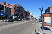
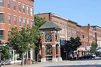
Sites of interest
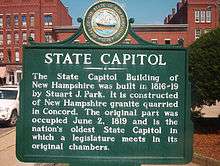
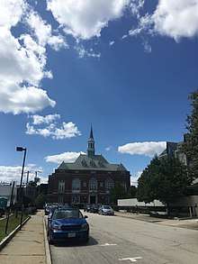
The New Hampshire State House, designed by architect Stuart Park and constructed between 1815 and 1818, is the oldest state house in which the legislature meets in its original chambers.[30] The building was remodeled in 1866, and the third story and west wing were added in 1910.
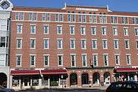
Across from the State House is the Eagle Hotel on Main Street, which has been a downtown landmark since its opening in 1827. U.S. Presidents Ulysses S. Grant, Rutherford Hayes, and Benjamin Harrison all dined there, and Franklin Pierce spent the night before departing for his inauguration. Other well-known guests included Jefferson Davis, Charles Lindbergh, Eleanor Roosevelt, Richard M. Nixon (who carried New Hampshire in all three of his presidential bids), and Thomas E. Dewey. The hotel closed in 1961.[31]
South from the Eagle Hotel on Main Street is Phenix Hall, which replaced "Old" Phenix Hall, which burned in 1893. Both the old and new buildings featured multi-purpose auditoriums used for political speeches, theater productions, and fairs. Abraham Lincoln spoke at the old hall in 1860; Theodore Roosevelt, at the new hall in 1912.[32]

North on Main Street is the Walker-Woodman House, also known as the Reverend Timothy Walker House, the oldest standing two-story house in Concord.[33] It was built for the Reverend Timothy Walker between 1733 and 1735.
On the north end of Main Street is the Pierce Manse, in which President Franklin Pierce lived in Concord before and following his presidency.[34] The mid-1830s Greek Revival house was moved from Montgomery Street to North Main Street in 1971 to prevent its demolition.
Beaver Meadow Golf Course, located in the northern part of Concord, is one of the oldest golf courses in New England.[35] Besides this golf course, other important sporting venues in Concord include Everett Arena and Memorial Field.
The SNOB (Somewhat North Of Boston) Film Festival, started in the fall of 2002, brings independent films and filmmakers to Concord and has provided an outlet for local filmmakers to display their films. SNOB Film Festival was a catalyst for the building of Red River Theatres, a locally owned, nonprofit, independent cinema in 2007. The SNOB Film Festival is one of the many arts organizations in the city.
Other sites of interest include the Capitol Center for the Arts, the New Hampshire Historical Society, which has two facilities in Concord, and the McAuliffe-Shepard Discovery Center, a planetarium named after Christa McAuliffe, the Concord teacher who died during the Space Shuttle Challenger disaster in 1986.
Education
Concord's public schools are within the Concord School District, except for schools in the Penacook area of the city, which are within the Merrimack Valley School District, a district which also includes several towns north of Concord. The only public high school in the Concord School District is Concord High School, which has about 2,000 students. The only public middle school in the Concord School District is Rundlett Middle School, which has roughly 1,500 students. Concord School District's elementary schools underwent a major re-configuration in 2012, with three newly constructed schools opening and replacing six previous schools. Kimball School and Walker School were replaced by Christa McAuliffe School on the Kimball School site, Conant School (and Rumford School, which closed a year earlier) were replaced by Abbot-Downing School at the Conant site, and Eastman and Dame schools were replaced by Mill Brook School, serving kindergarten through grade two, located next to Broken Ground Elementary School, serving grades three to five. Beaver Meadow School, the remaining elementary school, was unaffected by the changes.
Concord schools in the Merrimack Valley School District include Merrimack Valley High School and Merrimack Valley Middle School, which are adjacent to each other and to Rolfe Park in Penacook village, and Penacook Elementary School, just south of the village.
Concord has two parochial schools, Bishop Brady High School and Saint John Regional School.
Other area private schools include Concord Christian Academy, Parker Academy, Trinity Christian School, Shaker Road School, and St. Paul's School.
Concord is also home to NHTI, Concord's Community College, Granite State College, the University of New Hampshire School of Law, and the Franklin Pierce University Doctorate of Physical Therapy program.
Notes
- Mean monthly maxima and minima (i.e. the expected highest and lowest temperature readings at any point during the year or given month) calculated based on data at said location from 1981 to 2010.
- Official records for Concord were kept at downtown from September 1868 to April 1941 and at Concord Municipal Airport since May 1941; snow records date from December 1942. For more information, see ThreadEx
References
- "Concord, NH" NHES https://www.nhes.nh.gov/elmi/products/cp/profiles-htm/concord.htm
- "Concord, NH" NHES https://www.nhes.nh.gov/elmi/products/cp/profiles-htm/concord.htm
- "U.S. Census website". United States Census Bureau. Retrieved 2014-11-04.
- "Annual Estimates of the Resident Population: April 1, 2010 to July 1, 2018 (PEPANNRES): Incorporated Places: 2010 to 2018 – New Hampshire". Archived from the original on February 13, 2020. Retrieved July 2, 2019.
- "Annual Estimates of the Resident Population: April 1, 2010 to July 1, 2019 - United States -- Metropolitan and Micropolitan Statistical Area; and for Puerto Rico". U.S. Census Bureau. Retrieved March 29, 2020.
- "Geographic Identifiers: 2010 Demographic Profile Data (G001): Concord city, New Hampshire". American Factfinder. U.S. Census Bureau. Archived from the original on February 13, 2020. Retrieved July 2, 2019.
- Who's Buried in Grant's Tomb?
- Lyford, James; Amos Hadley; Howard F. Hill; Benjamin A. Kimball; Lyman D. Stevens; John M. Mitchell (1903). History of Concord, N.H. (PDF). Concord, N.H.: The Rumford Press. Archived from the original on 2014-07-15. Retrieved 2014-06-02.
- "Concord, NH" NHES. https://www.nhes.nh.gov/elmi/products/cp/profiles-htm/concord.htm
- Moore, Jacob (1824). Annals of the Town of Concord. Concord, N.H.: Jacob B. Moore. pp. 31–34.
- "National Register of Historic Places: Concord Historic District". Retrieved February 1, 2019.
- "Topo Map: Concord, New Hampshire, United States 01 July 1985". The National Map. U.S. Geological Survey. Archived from the original on 17 March 2012. Retrieved 2008-06-09.
- Foster, Debra H.; Batorfalvy, Tatianna N.; Medalie, Laura (1995). Water Use in New Hampshire: An Activities Guide for Teachers. U.S. Department of the Interior and U.S. Geological Survey. Archived from the original on 2011-07-17. Retrieved 2007-05-22.
- https://www.concordnh.gov/DocumentCenter/View/1456/Concord-Master-Plan?bidId=
- The Arbor Day Foundation. Arborday.org. Retrieved on 2013-08-02.
- "NowData - NOAA Online Weather Data". National Oceanic and Atmospheric Administration. Retrieved 2018-02-22.
- "Station Name: NH CONCORD MUNI AP". National Oceanic and Atmospheric Administration. Retrieved 2016-09-11.
- "WMO Climate Normals for CONCORD MUNICIPAL AP, NH 1961–1990". National Oceanic and Atmospheric Administration. Retrieved 2014-03-11.
- "Concord, New Hampshire, USA - Monthly weather forecast and Climate data". Weather Atlas. Retrieved 4 July 2019.
- "U.S. Decennial Census". Census.gov. Retrieved November 4, 2014.
- "Profile of General Population and Housing Characteristics: 2010 Demographic Profile Data (DP-1): Concord city, New Hampshire". U.S. Census Bureau, American Factfinder. Archived from the original on February 12, 2020. Retrieved February 11, 2013.
- "Selected Economic Characteristics: 2009-2011 American Community Survey 3-Year Estimates (DP03): Concord city, New Hampshire". U.S. Census Bureau, American Factfinder. Archived from the original on February 12, 2020. Retrieved February 11, 2013.
- "Concord NH CAFR June 2019". Retrieved 2020-03-29.
- "Concord Area Transit: Route Information". Archived from the original on February 2, 2019. Retrieved February 1, 2019.
- "City Council". City of Concord. Archived from the original on May 6, 2017. Retrieved April 12, 2017.
- Lubsdorf, Bob (2011-09-21). "Mayor to face challenger". Concord Monitor. Retrieved 2012-06-11.
- "City Manager". Archived from the original on May 11, 2017. Retrieved April 12, 2017.
- "Police". City of Concord. Archived from the original on May 11, 2017. Retrieved April 12, 2017.
- "Locations New Hampshire Correctional Facility for Women (NHCFW)". Archived from the original on June 12, 2018. Retrieved June 11, 2018.
- "State House History" (PDF). nh.gov. Archived (PDF) from the original on October 6, 2016. Retrieved August 19, 2016.
- "Eagle Hotel". waymarking.com. Archived from the original on May 1, 2015. Retrieved July 23, 2014.
- "New Phenix Hall". nhtourguide.com. Archived from the original on June 29, 2014. Retrieved July 23, 2014.
- "History of Concord Police Department (Pre 1853)". City of Concord, NH. 2014-03-07. Archived from the original on 2016-12-24. Retrieved 2017-01-23.
- "Learn". The Pierce Brigade. Archived from the original on 2010-08-16. Retrieved 2017-10-25.
- "Beaver Meadow Golf Course" (PDF). Beaver Meadow Golf Course. 2015-11-19. Archived from the original (PDF) on 2017-02-07. Retrieved 2017-02-06.
Further reading
External links
| Wikimedia Commons has media related to Concord, New Hampshire. |
| Wikivoyage has a travel guide for Concord, New Hampshire. |
| Wikisource has the text of a 1911 Encyclopædia Britannica article about Concord, New Hampshire. |
- City of Concord official website
- Concord School District website
- New Hampshire Economic and Labor Market Information Bureau Profile
- New Hampshire Historical Society
- Greater Concord Chamber of Commerce
- Visit Concord NH
Places adjacent to Concord, New Hampshire | ||||||||||
|---|---|---|---|---|---|---|---|---|---|---|
| ||||||||||
Municipalities and communities of Merrimack County, New Hampshire, United States | ||
|---|---|---|
| Cities |
|  Map of New Hampshire highlighting Merrimack County |
| Towns |
| |
| CDPs |
| |
| Other unincorporated communities |
| |
| Footnotes | ‡This populated place also has portions in an adjacent county or counties | |
Concord (capital) | ||
| Topics |
|  Seal of New Hampshire |
| Regions |
| |
| Counties |
| |
| Cities |
| |
| Towns |
| |
| Townships |
| |
| Topics |
| ||||||
|---|---|---|---|---|---|---|---|
| States | |||||||
| Major cities |
| ||||||
| State capitals | |||||||
| Transportation |
| ||||||
| |||||||
| Authority control |
|
|---|