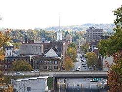
Easton, Pennsylvania
Easton is a city in and the county seat of Northampton County, Pennsylvania, United States.[2] The city's population was 26,800 as of the 2010 census.[3] Easton is located at the confluence of the Delaware River and the Lehigh River, roughly 55 miles (89 km) north of Philadelphia and 70 miles (110 km) west of New York City.
Easton, Pennsylvania | |
|---|---|
 | |
 Flag | |
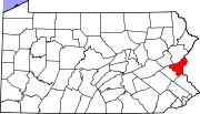
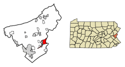 Location of Easton in Northampton County, Pennsylvania. | |
 Easton Location in Pennsylvania  Easton Easton (the United States) | |
| Coordinates: 40°41′18″N 75°12′59″W | |
| Country | United States |
| State | Pennsylvania |
| County | Northampton |
| Government | |
| • Mayor | Sal Panto Jr. (D) |
| Area | |
| • Total | 4.86 sq mi (12.6 km2) |
| • Land | 4.26 sq mi (11.0 km2) |
| • Water | 0.60 sq mi (1.6 km2) |
| Elevation | 211 ft (64 m) |
| Population (2010) | |
| • Total | 26,800 |
| • Estimate (2018)[1] | 27,216 |
| • Density | 5,500/sq mi (2,100/km2) |
| Time zone | UTC-5 (EST) |
| • Summer (DST) | UTC-4 (EDT) |
| ZIP Codes | 18040, 18042-18045 |
| Area code(s) | 610 and 484 |
| FIPS code | 42-21648 |
| Website | http://www.easton-pa.com |
Easton is the easternmost city in the Lehigh Valley, a region of 731 square miles (1,893 km2) that is home to more than 800,000 people. Together with Allentown and Bethlehem, the Valley embraces the Allentown-Bethlehem-Easton metropolitan area, including Lehigh, Northampton, and Carbon counties within Pennsylvania, and Warren County in the adjacent state of New Jersey. Easton is the smallest of the three Lehigh Valley cities, with approximately one-fourth of the population of the largest Lehigh Valley city, Allentown. In turn, this metropolitan area comprises Pennsylvania's third-largest metropolitan area and the state's largest and most populous contribution to the greater New York City metropolitan area.
The city is split up into four sections: Historic Downtown, which lies directly to the north of the Lehigh River, to the west of the Delaware River, continuing west to Sixth Street; The West Ward, which lies between Sixth and Fifteenth Streets; The South Side, which lies south of the Lehigh River; and College Hill, a neighborhood on the hills to the north of downtown, which is the home of Lafayette College, a liberal arts and engineering institution. The boroughs of Wilson, West Easton, and Glendon are also directly adjacent to the city; the first and largest of which, Wilson, partially aligns in the same North-South Grid as the city of Easton.
The greater Easton area consists of the city, three townships (Forks, Palmer, and Williams), and three boroughs (Glendon, West Easton, and Wilson).
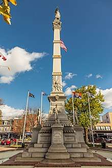
Centre Square, the town square of the city's Downtown neighborhood, is home to the Soldiers' & Sailors' Monument, a memorial for Easton area veterans killed during the American Civil War. The Peace Candle, a candle-like structure, is assembled and disassembled every year atop the Civil War monument for the Christmas season.[4]
The Norfolk Southern Railway's Lehigh Line (formerly the main line of the Lehigh Valley Railroad), runs through Easton on its way to Bethlehem and Allentown heading west and to Phillipsburg, New Jersey just across the Delaware River.
History
Colonial era
The Lenape Native Americans originally referred to the area as "Lechauwitank", or "The Place at the Forks". The site of the future city was part of the land obtained from the Delawares by the Walking Purchase.[5] Thomas Penn set aside a 1,000 acres (4.0 km2) tract of land at the confluence of the Lehigh and Delaware rivers for a town. Easton was settled by Europeans in 1739 and founded in 1752,[6] and was so named at the request of Penn; he had recently married Juliana Fermor, the daughter of Lord Pomfret whose estate was called Easton Neston, near Towcester, Northamptonshire, England.[7] As Northampton County was being formed at this time, Easton was selected as its county seat.
During the French and Indian War, the Treaty of Easton was signed here by the British colonial government of the Province of Pennsylvania and the Native American tribes in the Ohio Country, including the Shawnee and Lenape.
Revolutionary War
Easton was an important military center during the American Revolutionary War. During the Revolutionary War, Easton had a military hospital.[8] On 18 June 1779, General John Sullivan led 2,500 Continentals from Easton to engage British Indian allies on the frontier.[9] Easton was one of the first three places the Declaration of Independence was publicly read (along with Philadelphia and Trenton). It is claimed that the Easton flag was flown during that reading,[10] making it one of the first "Stars and Stripes" to fly over the colonies.[11] This flag was used by a militia company during the War of 1812, and currently serves as Easton's municipal flag.
Industrial history
Sited at the confluence of the rapidly flowing Lehigh River's waters with the more stately waters of the deeper wider Delaware, Easton became a major commercial center during the canal and railroad periods of the 19th century, when it would become a transportation hub for the eastern steel industry. The Delaware Canal, was quickly built soon after the lower Lehigh Canal (1818) became effective in regularly and reliably delivering much needed anthracite coal, into more settled lands along the rivers. And eventually the Morris would also serve to connect the rapidly developing Coal Regions to the north and west, to the fuel starved iron works to the west, the commercial port of Philadelphia to the south, and to the many home owners seeking fuel for heat within Pennsylvania, Maryland, New Jersey, Delaware and New York. Seeing other ways of exploiting the new fuel source, other entrepreneurs quickly moved to connect across the Delaware River reaching into the New York City area to the east via a connection with the Morris Canal in Phillipsburg, New Jersey, so the town became a canal nexus or hub from which the Coal from Mauch Chunk reached the world. The early railroads were often built to parallel and speed shipping along transportation corridors, and by the late 1860s the Lehigh and Susquehanna Railroad (LH&S) and Lehigh Valley Railroad (LVRR) were built to augment the bulk traffic through the canals and provide lucrative passenger travel services. The LVRR, known as 'the Black Diamond Line' would boast the twice daily "Black Diamond Express" daily passenger trains to and from New York City and Buffalo, New York via Easton. The Central Railroad of New Jersey (CNJ), would lease and operate the LH&S tracks from the 1870s until the Conrail consolidations absorbed both the Central Railroad of New Jersey and Lehigh Valley Railroad in 1966. Today, the Lehigh Valley Railroad's main line is the only major rail line that goes through Easton and is now known as the Lehigh Line; the Lehigh Line was bought by the Norfolk Southern Railway in 1999.
Canal transportation was largely replaced by railroads in the mid-19th century with Easton being a hub for five railroads including the Jersey Central, Lehigh Valley Railroad and others. Easton lost its prominence in passenger transportation with the rise of the automobile in the mid-20th century. The development of improved logistics, transfer and handling methods lead to other regions profiting from freight transportation rather than Easton.
Like the Pennsylvania Dutch region to the southwest, Easton has a strong German heritage. The Pennsylvania Argus, a German-language newspaper, was published in Easton until 1917. As part of their heritage, the Germans put up one of the continent's earliest Christmas trees in Easton; Daniel Foley's book states that "Another diary reference unearthed recently makes mention of a tree set-up at Easton, Pennsylvania, in 1816."[12] There is a plaque in Scott Park (along the Delaware River) commemorating this event.
Historians of angling believe that Samuel Phillipe, an Easton gunsmith, invented the six-strip split-cane bamboo fly rod. A Pennsylvania Historical and Museum Commission plaque near Center Square commemorates this event.[13]
Government
Easton operates a mayor-in-council city government. Residents elect a city controller, six city councilpersons and a mayor who is also a voting member of the city council. All of these officials are elected to four-year terms.[14][15]
The incumbent mayor, Democrat Sal Panto, Jr., was re-elected to his third consecutive term in 2015; he had previously served two terms as mayor during the 1980s.[16][17]
Easton is part of Pennsylvania's 7th congressional district, represented in the United States House of Representatives by Democrat Susan Wild, first elected to this office in 2018.
Geography
Easton is located at 40°41′18″N 75°12′59″W (40.688248, −75.216458).[18] According to the United States Census Bureau, the city has a total area of 4.7 square miles (12 km2), of which, 4.3 square miles (11 km2) is land and 0.4 square miles (1.0 km2) (8.39%) is water, including Bushkill Creek and the Lehigh and Delaware rivers.
Downtown Easton lies at the confluence of the Lehigh River and Delaware River and is a low-lying area surrounded by hills to the north, west, and south. North of downtown is College Hill, the home of Lafayette College. South Easton, divided by the Lehigh River from the rest of the city, was a separate borough until 1898; it was settled initially by Native Americans, later by canal workers, and then was later the home of several silk mills.
Climate
Easton experiences a humid continental climate (Köppen climate classification Dfa). Summers are usually hot and very muggy, averaging in the mid-80s during the day, though the high humidity makes it feel much warmer. Fall and spring months are typically mild, offering many days in the mid-60s, as well as stronger winds. Winters are usually very cold and produce about 30 inches of snow. The local hardiness zone is 6b.
| Climate data for Easton | |||||||||||||
|---|---|---|---|---|---|---|---|---|---|---|---|---|---|
| Month | Jan | Feb | Mar | Apr | May | Jun | Jul | Aug | Sep | Oct | Nov | Dec | Year |
| Record high °F (°C) | 72 (22) |
81 (27) |
87 (31) |
93 (34) |
97 (36) |
100 (38) |
105 (41) |
100 (38) |
99 (37) |
93 (34) |
80 (27) |
72 (22) |
105 (41) |
| Average high °F (°C) | 36 (2) |
40 (4) |
49 (9) |
61 (16) |
72 (22) |
80 (27) |
84 (29) |
82 (28) |
75 (24) |
64 (18) |
53 (12) |
41 (5) |
61 (16) |
| Average low °F (°C) | 19 (−7) |
22 (−6) |
29 (−2) |
39 (4) |
48 (9) |
58 (14) |
63 (17) |
61 (16) |
53 (12) |
41 (5) |
33 (1) |
24 (−4) |
41 (5) |
| Record low °F (°C) | −15 (−26) |
−12 (−24) |
−5 (−21) |
12 (−11) |
28 (−2) |
39 (4) |
46 (8) |
41 (5) |
30 (−1) |
21 (−6) |
3 (−16) |
−8 (−22) |
−15 (−26) |
| Average precipitation inches (mm) | 3.03 (77) |
2.80 (71) |
3.39 (86) |
3.56 (90) |
4.14 (105) |
4.31 (109) |
4.95 (126) |
3.69 (94) |
4.62 (117) |
3.88 (99) |
3.50 (89) |
3.58 (91) |
42.45 (1,078) |
| Source: Weather Channel | |||||||||||||
Demographics
| Historical population | |||
|---|---|---|---|
| Census | Pop. | %± | |
| 1790 | 708 | — | |
| 1800 | 1,045 | 47.6% | |
| 1810 | 1,657 | 58.6% | |
| 1820 | 2,370 | 43.0% | |
| 1830 | 3,529 | 48.9% | |
| 1840 | 4,865 | 37.9% | |
| 1850 | 7,250 | 49.0% | |
| 1860 | 8,944 | 23.4% | |
| 1870 | 10,987 | 22.8% | |
| 1880 | 11,924 | 8.5% | |
| 1890 | 14,481 | 21.4% | |
| 1900 | 25,238 | 74.3% | |
| 1910 | 28,523 | 13.0% | |
| 1920 | 33,813 | 18.5% | |
| 1930 | 34,468 | 1.9% | |
| 1940 | 33,589 | −2.6% | |
| 1950 | 35,632 | 6.1% | |
| 1960 | 31,955 | −10.3% | |
| 1970 | 29,450 | −7.8% | |
| 1980 | 26,027 | −11.6% | |
| 1990 | 26,276 | 1.0% | |
| 2000 | 26,263 | 0.0% | |
| 2010 | 26,800 | 2.0% | |
| Est. 2018 | 27,216 | [1] | 1.6% |
| [19][20][21] | |||
As of the 2010 census, the city was 67.2% White, 16.8% Black or African American, 0.4% Native American, 2.4% Asian, 0.1% Native Hawaiian, and 4.9% were two or more races. 19.9% of the population were of Hispanic or Latino ancestry.[22]
As of the census[23] of 2000, there were 26,263 people, 9,544 households, and 5,735 families residing in the city. The population density was 6,168.4 per square mile (2,380.3/km2). There were 10,545 housing units at an average density of 2,476.7 per square mile (955.7/km2). The racial makeup of the city was 78.48% White, 12.71% African American, 0.24% Native American, 1.66% Asian, 0.11% Pacific Islander, 3.67% from other races, and 3.13% from two or more races. Hispanic or Latino of any race were 9.79% of the population. The increase in Hispanic/Latinos—from less than 10% of the population in the 2000 census, to nearly 20% in the 2010 census, is a significant change in the city's demographics. The growth in Hispanic residents is similar to increases in Allentown and Bethlehem, the two other major cities in the Lehigh Valley.
There were 9,544 households, out of which 30.5% had children under the age of 18 living with them, 37.7% were married couples living together, 16.6% had a female householder with no husband present, and 39.9% were non-families. 31.5% of all households were made up of individuals, and 11.0% had someone living alone who was 65 years of age or older. The average household size was 2.46 and the average family size was 3.10.
In the city, the population was spread out, with 23.3% under the age of 18, 16.3% from 18 to 24, 29.9% from 25 to 44, 18.6% from 45 to 64, and 11.9% who were 65 years of age or older. The median age was 32 years. For every 100 females, there were 97.4 males. For every 100 females age 18 and over, there were 96.1 males.
| Easton | |
|---|---|
| Crime rates* (2008) | |
| Violent crimes | |
| Homicide | 7.7 |
| Rape | 49.9 |
| Robbery | 299.2 |
| Aggravated assault | 245.5 |
| Total violent crime | 602.2 |
| Property crimes | |
| Burglary | 602.1 |
| Larceny-theft | 3,068.4 |
| Motor vehicle theft | 253.2 |
| Arson | 42.2 |
| Total property crime | 3,923.8 |
Notes *Number of reported crimes per 100,000 population. 2008 population: 26,072 Source: 2008 FBI UCR Data | |
The median income for a household in the city was $33,162, and the median income for a family was $38,704. Males had a median income of $32,356 versus $23,609 for females. The per capita income for the city was $15,949. About 12.3% of families and 16.0% of the population were below the poverty line, including 21.3% of those under age 18 and 11.2% of those age 65 or over.
Education
Public education
The Easton Area School District serves the residents of the city of Easton along with Forks and Palmer Townships and the village of Martins Creek to the north. As of the 2000 census, the combined population of the municipalities in the Easton Area School District was 53,554.
The school district has seven elementary schools (Cheston, Forks, March, Palmer, Paxinosa, Shawnee and Tracy) for grades K-5, Easton Area Middle School Campus (in Forks Township) for grades 6–8, and Easton Area High School (in Palmer Township) for grades 9–12. Total student enrollment is about 9000 students in all grades. There is also an alternative school called Easton Academy.
Easton Area High School is known[24] for its long-standing athletic rivalry with Phillipsburg High School in neighboring Phillipsburg, New Jersey. The two teams play an annual football game on Thanksgiving Day that is considered one of the largest and longest-standing rivalries in American high school football. 2006 marked the 100th anniversary of the Easton-Phillipsburg high school football rivalry[24] The game, which was shown on ESPN, was won by Easton. In 2009, Easton was the location of the Gatorade REPLAY Game in which the 1993 teams from the Easton vs. P-Burg Game met again to resolve the game, which ended in a 7–7 tie. The REPLAY Game was won by Phillipsburg, 27–12.[25]
Easton Area High School athletes compete in the East Penn Conference, which consists of the 12 largest high schools in the Lehigh Valley. Easton holds the third most LVIAC championships in all sports, behind only Parkland High School and Emmaus High School.[26]
Easton is also home to Catholic Notre Dame High School.
Post-secondary education
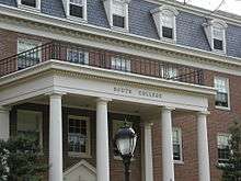
Easton is the home of one four-year college, Lafayette College, which was established in 1826. Lafayette is located in the College Hill section of Easton and is home to 2,500 undergraduate students.[27] In 2017 the U.S. News & World Report ranked Lafayette as the 36th best liberal arts school in the country.[27]
Before the American Civil War, Easton was the location of Union Law School, which was founded in 1846 and seems to have foundered fairly soon after the 1856 death of its founder, Judge Washington McCartney. (While at least one student, future Wisconsin state senator Robert L. D. Potter, graduated in the spring of 1857, a historian in 2000 dismissed Union in an endnote as "a one-man operation that died with him" [i.e., McCartney].[28])
Industry

Easton's Two Rivers Landing is the home of two interactive children's museums, the National Canal Museum, which focuses on the importance of canals in the region, and the Crayola Experience, which is owned by Crayola LLC (formerly known as Binney & Smith), a major toy manufacturer based in nearby Forks Township. The global headquarters for Victaulic is also based in nearby Forks Township. The city was also once the home of Dixie Cup Corporation, the manufacturer of Dixie Cups and other consumer products. Majestic Athletic, current provider of uniforms for Major League Baseball, is based in nearby Palmer Township.
The Lehigh Valley Railroad, Central Railroad of New Jersey using the Lehigh and Susquehanna Railroad, Lehigh and Hudson River Railway and Conrail are major defunct railroads that operated in Easton. The Norfolk Southern Railway is now the only railroad in Easton.
Media
Easton's daily newspaper is The Express-Times. The Morning Call, based in Allentown, also is widely read in the city. Easton is part of the Philadelphia DMA, but also receives numerous radio and television channels from New York City, as well as the smaller Scranton-Wilkes-Barre media market to the northwest.
Two television stations are based in the Easton area: PBS affiliate WLVT Channel 39 in Bethlehem, and independent station WFMZ Channel 69 in Allentown.
Four radio stations are based in Easton: WEEX, a sports radio station broadcasting at 1230 AM, WODE-FM "The Hawk", a classic rock station broadcasting at 99.9 FM, WCTO "Cat Country 96," a country music station broadcasting on 96.1 FM, and WJRH, a Lafayette College radio station broadcasting at 104.9 FM. In addition, WDIY-FM, a National Public Radio affiliate located in Bethlehem, maintains a translator in Easton broadcasting at 93.9 FM.
Two national magazines, Runner's World and Bicycling, are based in Easton.[29]
Easton is becoming an increasingly sought after destination for motion pictures filming on location.
Telecommunications
Easton was once served only by the 215 area code from 1947 (when the North American Numbering Plan of the Bell System went into effect) until 1994. In response to southeastern Pennsylvania's growing telecommunication demand, Easton telephones exchanges were switched to area code 610 in 1994. An overlay area code, 484, was added to the 610 service area in 1999.[30]
Infrastructure
Transportation
Major state, federal, or interstate highways serving Easton include I-78, US 22, PA 33, PA 248 and PA 611 (Delaware Drive). Major east−west roads (from north to south) in Easton include Corriere Road, Zucksville Road, Northwood Avenue, Lafayette Street, Hackett Avenue, Northampton Street, Butler Street (known as William Penn Highway west of Wilson, then as Easton Avenue nearing Bethlehem), Freemansburg Avenue, and Canal Street. Major north−south roads (from west to east) in Easton include Farmersville Road, Stones Crossing Road, Greenwood Avenue, 25th Street, Bushkill Drive, 13th Street, Centre Street, Sullivan Trail, Richmond Road, 3rd Street (Known as Smith Avenue south of the Lehigh River, then as Philadelphia Road farther south), Cattell Street, Riverside Drive, and Delaware Drive (PA 611).
Air transport to and from Easton is available through Lehigh Valley International Airport, which is located approximately 15 miles (24 km) west of the city, in Hanover Township.
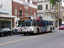
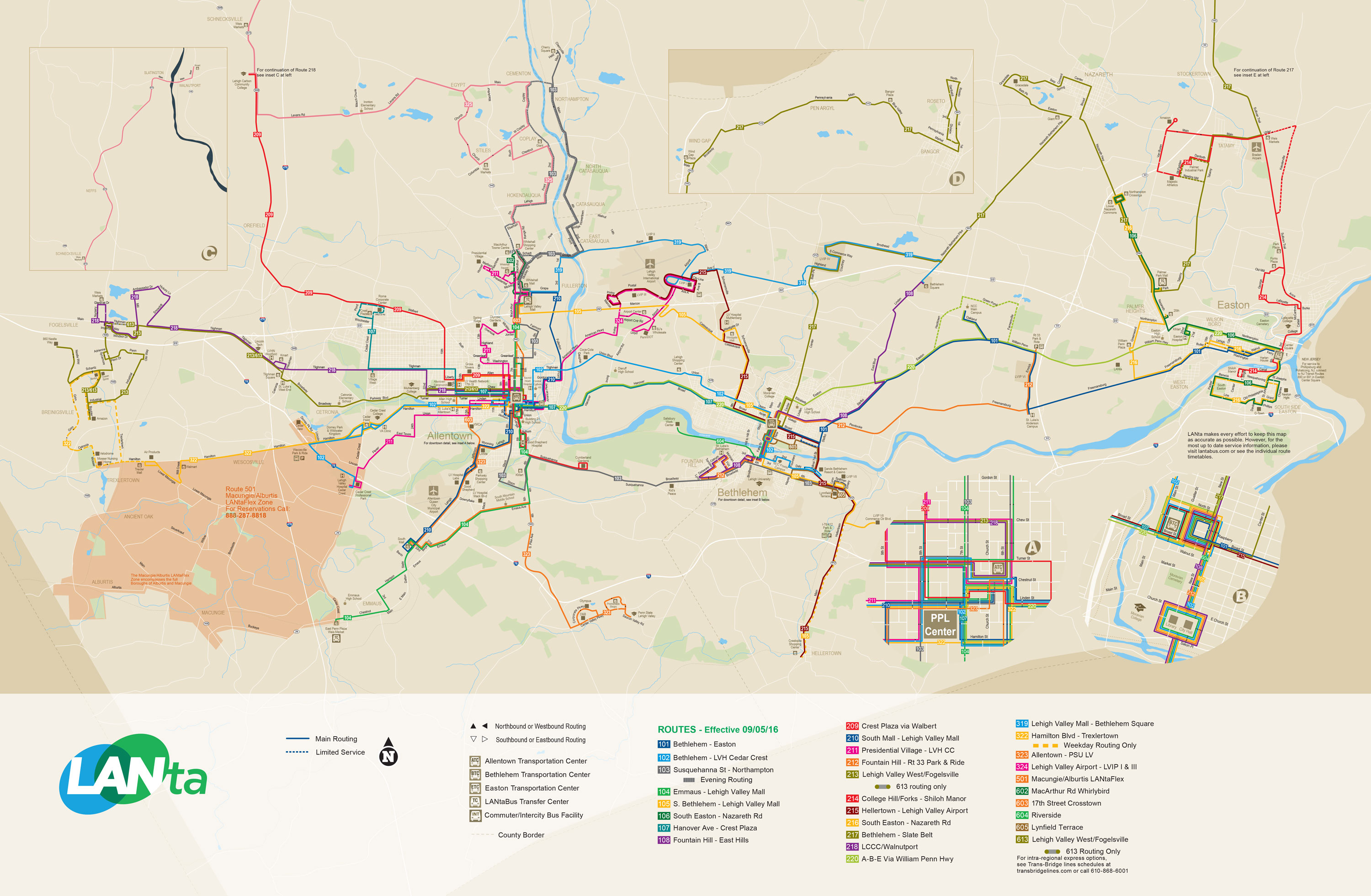
Local bus transportation is provided by LANTA, which serves Lehigh and Northampton counties. The Easton Intermodal Transportation Center in downtown Easton serves as a hub for LANTA buses. NJ Transit provides bus service from Center Square in Easton to Phillipsburg and Pohatcong in New Jersey along the 890 and 891 routes.[31] Greyhound Lines provides intercity bus service to Easton, stopping at the Easton Intermodal Transportation Center. Trans-Bridge Lines provides regular bus service to New York City.
Easton has no passenger rail service. Until 1983 NJ Transit's Raritan Valley Line terminated at Phillipsburg, on the other side of the Delaware River from Easton. The line now stops at High Bridge, New Jersey, roughly 20 miles (32 km) to the east. Under NJT's I-78 Corridor study this service would be restored.
The former Lehigh Valley Railroad main line, the Lehigh Line, travels through Easton and is owned by the Norfolk Southern Railway.
Utilities
Electricity in Easton is provided by Met-Ed, a subsidiary of FirstEnergy.[32][33] Natural gas service in Easton is provided by UGI Utilities.[34][35] The city's Public Works department provides water, sewer service, and trash and recycling collection to Easton.[36] Easton's water supply comes from the Delaware River. The city's water is treated at a filtration plant along the Delaware River and then stored in reservoirs and delivered to customers. The Easton Suburban Water Authority serves suburban areas outside of Easton and purchases water from the city's Public Works department.[37] The city's Public Works department contracts with Raritan Valley Disposal for trash and recycling collection in Easton.[38]
Notable people
- Eddie Alkire – music educator, inventor and Hawaiian guitar virtuoso
- Chuck Amato – former head football coach, North Carolina State University
- Lisa Ann – pornographic actress
- Christian Bauman – novelist
- James McKeen Cattell – first United States psychology professor
- Jack Coleman – actor, NBC's Heroes
- Joseph F. Crater – subject of infamous missing person case[39]
- George Daniel – commissioner, National Lacrosse League
- Keno Davis - basketball coach, Central Michigan
- Parke H. Davis – football coach and lawyer
- Don Dixon – astronomical artist
- Omar Doom – actor and musician
- Michael F. Flynn – science fiction writer
- Larry Holmes – former world heavyweight boxing champion (fought under nickname "The Easton Assassin")
- Frank Reed Horton – founder of Alpha Phi Omega service fraternity
- Greg Howe – guitar virtuoso
- Daniel Dae Kim – actor, ABC's Lost and CBS's Hawaii Five-0
- Christopher Lennertz – music composer, Alvin and the Chipmunks and Supernatural
- J. Robert Lennon – novelist
- Samuel D. Gross - surgeon
- Francis March – academic
- Peyton C. March – former U.S. Army Chief of Staff
- Kristen McMenamy – fashion model
- Robert B. Meyner – former Governor of New Jersey
- Mulgrew Miller – jazz pianist
- Randall Munroe – writer, XKCD comic series
- Alix Ohlin – novelist
- Frank Pulli – major league baseball umpire
- Sally Jessy Raphael – television talk show host
- Andrew Horatio Reeder – Governor of Kansas
- William Findlay Rogers – former Mayor of Buffalo, New York
- Dee Roscioli – Broadway actress, Elphaba in Wicked
- Alfred A. Schlert - Roman Catholic bishop
- Florence B. Seibert – biochemist, winner of the Garvan–Olin Medal
- Charles Sitgreaves – (1803–1878), represented New Jersey's 3rd congressional district from 1865–1869[40]
- Samuel Sitgreaves – U.S. commissioner to Great Britain, U.S. Congressman
- Jennie Somogyi – ballerina, principal dancer, New York City Ballet
- Peter Stevenson – artist and illustrator
- Robert Sun – inventor of 24 Game
- George Taylor – signator to the Declaration of Independence
- Jim Trimble – professional football coach, inventor of standard slingshot goalposts
- Dave Van Horne – Major League Baseball broadcaster, original voice of the Montreal Expos
- Jack Wallaesa – Major League Baseball player
- Samuel Wallin – former U.S. Congressman
- Bobby Weaver – gold medalist 1984 Summer Olympics, freestyle wrestling
- Bob Weiss – professional basketball player and coach
- Charles A. Wikoff – most senior-ranking U.S. Army officer killed in the Spanish–American War
- Roger Ross Williams - award-winning director, producer and writer, and the first African American director to win an Oscar
Events
See also
- Delaware and Lehigh National Heritage Corridor
- National Canal Museum
- Northampton County Prison
- Northampton Street Bridge aka The Free Bridge
- Peace Candle
References
- "QuickFacts: Easton City, Pennsylvania". US Census Bureau. Retrieved July 15, 2019.
- "Find a County". National Association of Counties. Archived from the original on 2012-07-12. Retrieved 2011-06-07.
- "Population Finder: Easton, Pennsylvania". U.S. Census Bureau. Archived from the original on 2020-02-12. Retrieved 2009-10-28.
- "International Brotherhood of Electrical Workers". IBEW Journal. 90. 1991.
- "Easton (Pennsylvania, United States)". Britannica Online Encyclopedia. Retrieved 2012-06-23.
- "Northampton County – 4th class" (PDF). Pennsylvania Historical and Museum Commission. Retrieved 2007-06-03.
- Skillman, David Bishop (1932). The Biography of a College: Being the History of the First Century of the Life of Lafayette College. Easton, Pennsylvania: Lafayette College.
- John C. Fitzpatrick, The Writings of George Washington from the Original Manuscript Sources, 1745–1799, 39 vols. (Washington, D.C., 1931-1944), 6: 327–328.
- Axelrod, Alan, The Real History of the American Revolution, 2007, p. 264
- Mastai, Boleslaw; D'Otrange, Marie-Louise (1973). The Stars and the Stripes. The American Flag as Art and as History from the Birth of the Republic to the Present. New York: Alfred A. Knopf. p. 39. ISBN 0-394-47217-9.
- "Easton Heritage Day". heritageday.org.
- Foley, Daniel J. (1960). The Christmas Tree. Philadelphia: Chilton Co., Book Division. p. 72.
- Herd, Dr. Andrew N. (2005). "Sammuel Phillipe". A Fly Fishing History. Archived from the original on 7 April 2009. Retrieved 5 November 2009.
- "City of Easton - City Government - Elected Officials". Archived from the original on July 29, 2013. Retrieved July 23, 2013.
- "City of Easton Home Rule Charter" (PDF). Retrieved July 23, 2013.
- "Easton Voters Choose Panto Again". November 9, 2011. Retrieved July 23, 2013.
- Landauer, Bill (May 19, 2015). "Panto unopposed, Brown leads council vote in Easton". The Morning Call. Retrieved 20 October 2017.
- "US Gazetteer files: 2010, 2000, and 1990". United States Census Bureau. 2011-02-12. Retrieved 2011-04-23.
- "1940 Census - Census of Population and Housing - U.S. Census Bureau". Census.gov. Archived from the original on 2010-03-27. Retrieved 2012-06-23.
- "1960 Census of Population and Housing". Census.gov. 2012-05-25. Archived from the original on 2010-05-05. Retrieved 2012-06-23.
- "1990 Census of Population and Housing" (PDF). Census.gov. Retrieved 2013-07-23.
- "Census 2010: Pennsylvania". Usatoday.Com. Retrieved 2012-06-23.
- "U.S. Census website". United States Census Bureau. Retrieved 2008-01-31.
- Erik Brady (2006-11-23). "Every year fields the game of the century". USA Today. Retrieved 2007-05-29.
- Conover, Allan (April 29, 2009). "Phillipsburg beats Easton in Gatorade Replay football". Warren Reporter. Phillipsburg, NJ. Retrieved 13 August 2010.
- "LVIAC Past Champions" (PDF). Lehigh Valley Interscholastic Athletic Conference. Archived from the original (PDF) on 2011-05-22. Retrieved 2010-08-13.
- "US News and World Report: Lafayette College". Retrieved 24 February 2017.
- Knupfer, Peter B. Union As It Is: Constitutional Unionism and Sectional Compromise, 1787-1861 Chapel Hill: University of North Carolina Press, 2000; chapter 2, endnote 54
- Kelly, Keith J. (2018-09-20). "Runner's World staff moving to a former bowling alley". New York Post. Retrieved 2018-12-30.
- "NANP-Overlay of 610 (Pennsylvania) Numbering Plan Area (NPA) with 484 NPA" (PDF). (359 KB)
- System Map (Map). LANTA. Retrieved February 14, 2018.
- "Our Service Area". FirstEnergy. Retrieved October 10, 2017.
- "Electric Service Tariff" (PDF). Met-Ed. July 17, 2017. pp. 8–10. Retrieved October 10, 2017.
- "Geographic Footprint". UGI. Retrieved October 4, 2017.
- "Gas Tariff" (PDF). UGI Utilities. July 7, 2017. pp. 5–6. Retrieved October 10, 2017.
- "Public Works - About Us". City of Easton. Retrieved December 5, 2017.
- "Public Works - Drinking Water Information". City of Easton. Retrieved December 5, 2017.
- "Public Works - Trash Pick-Up". City of Easton. Retrieved December 5, 2017.
- Garret, Robert (August 11, 1980). "Good Night Judge Crater, Wherever you Are..." New York Magazine. New York: New York Media, LLC. 13 (11): 11–12. ISSN 0028-7369. Retrieved January 21, 2011.
- Charles Sitgreaves, Biographical Directory of the United States Congress. Accessed August 18, 2007.
- "Riverside Festival of the Arts". Riverside Festival of the Arts Website. Arts Community of Easton. Retrieved 2011-08-14.
- "Welcome". Easton Garlic Festival Website. Easton Garlic Festival. Retrieved 2010-10-05.
- "Easton Heritage Day". Heritage Day. Retrieved 2011-02-14.
External links
| Wikimedia Commons has media related to Easton, Pennsylvania. |
| Wikisource has the text of the 1911 Encyclopædia Britannica article Easton. |

- Official website
Places adjacent to Easton, Pennsylvania | ||||||||||
|---|---|---|---|---|---|---|---|---|---|---|
| ||||||||||
Easton, Pennsylvania | ||||||||||||||||||||||||||||||||||||||||||||||||||||||||||||
|---|---|---|---|---|---|---|---|---|---|---|---|---|---|---|---|---|---|---|---|---|---|---|---|---|---|---|---|---|---|---|---|---|---|---|---|---|---|---|---|---|---|---|---|---|---|---|---|---|---|---|---|---|---|---|---|---|---|---|---|---|
| ||||||||||||||||||||||||||||||||||||||||||||||||||||||||||||
| Authority control |
|---|