1910 United States Census
The United States Census of 1910, conducted by the Census Bureau on April 15, 1910, determined the resident population of the United States to be 92,228,496, an increase of 21 percent over the 76,212,168 persons enumerated during the 1900 Census. The 1910 Census switched from a portrait page orientation to a landscape orientation.
| Thirteenth Census of the United States | |
|---|---|
 U.S. Census Bureau Seal | |
| General information | |
| Country | United States |
| Date taken | April 15, 1910 |
| Total population | 92,228,496 |
| Percent change | |
| Most populous state | New York 9,113,614 |
| Least populous state | Nevada 81,875 |
Census questions
The 1910 census collected the following information:[1]
- address
- name
- relationship to head of family
- sex
- race
- age
- marital status and, if married, number of years of present marriage
- for women, number of children born and number now living
- place of birth and mother tongue of person, and their parents
- if foreign born, year of immigration; whether naturalized; whether able to speak English and, if unable, language spoken
- occupation, industry and class of worker
- if an employee, whether out of work during year
- literacy
- school attendance
- whether home owned or rented, and, if owned, whether mortgaged
- whether farm or house
- whether a survivor of Union or Confederate Army or Navy
- whether blind, deaf or dumb
Full documentation for the 1910 census, including census forms and enumerator instructions, is available from the Integrated Public Use Microdata Series.
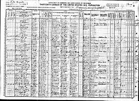
Column titles
The column titles in the census form are as follows:
LOCATION.
Street, avenue, road, etc.
House number (in cities or towns).
1. Number of dwelling house in order of visitation.
2. Number of family in order of visitation.
3. NAME of each person whose place of abode on April 15, 1910, was in this family.
Enter surname first, then the given name and middle initial, if any.
Include every person living on April 15, 1910. Omit children born since April 15, 1910.
RELATION.
4. Relationship of this person to the head of the family.
PERSONAL DESCRIPTION.
5. Sex.
6. Color or race.
7. Age at last birthday.
8. Whether single, married, widowed, or divorced.
9. Number of years of present marriage.
10. Mother of how many children: Number born.
11. Mother of how many children: Number now living.
NATIVITY.
Place of birth of each person and parents of each person enumerated. If born in the United States, give the state or territory. If of foreign birth, give the country.
12. Place of birth of this Person.
13. Place of birth of Father of this person.
14. Place of birth of Mother of this person.
CITIZENSHIP.
15. Year of immigration to the United States.
16. Whether naturalized or alien.
17. Whether able to speak English; or, if not, give language spoken.
OCCUPATION.
18. Trade or profession of, or particular kind of work done by this person, as spinner, salesman, laborer, etc.,
19. General nature of industry, business, or establishment in which this person works, as cotton mill, dry goods store, farm, etc.
20. Whether as employer, employee, or work on own account.
If an employee – 21. Whether out of work on April 15, 1910.
22. Number of weeks out of work during year 1909.
EDUCATION.
23. Whether able to read.
24. Whether able to write.
25. Attended school any time since September 1, 1909.
OWNERSHIP OF HOME.
26. Owned or rented.
27. Owned free or mortgaged.
28. Farm or house.
29. Number of farm schedule.
30. Whether a survivor of the Union or Confederate Army or Navy.
31. Whether blind (both eyes).
32. Whether deaf and dumb.
State rankings
| Rank | State | Population |
|---|---|---|
| 1 | New York | 9,113,614 |
| 2 | Pennsylvania | 7,665,111 |
| 3 | Illinois | 5,638,591 |
| 4 | Ohio | 4,767,121 |
| 5 | Texas | 3,896,542 |
| 6 | Massachusetts | 3,366,416 |
| 7 | Missouri | 3,293,335 |
| 8 | Michigan | 2,810,173 |
| 9 | Indiana | 2,700,876 |
| 10 | Georgia | 2,609,121 |
| 11 | New Jersey | 2,537,167 |
| 12 | California | 2,377,549 |
| 13 | Wisconsin | 2,333,860 |
| 14 | Kentucky | 2,289,905 |
| 15 | Iowa | 2,224,771 |
| 16 | North Carolina | 2,206,287 |
| 17 | Tennessee | 2,184,789 |
| 18 | Alabama | 2,138,093 |
| 19 | Minnesota | 2,075,709 |
| 20 | Virginia | 2,061,612 |
| 21 | Mississippi | 1,797,114 |
| 22 | Kansas | 1,690,949 |
| 23 | Oklahoma | 1,657,155 |
| 24 | Louisiana | 1,656,388 |
| 25 | Arkansas | 1,574,449 |
| 26 | South Carolina | 1,515,400 |
| 27 | Maryland | 1,295,346 |
| 28 | West Virginia | 1,221,119 |
| 29 | Nebraska | 1,192,214 |
| 30 | Washington | 1,141,990 |
| 31 | Connecticut | 1,114,756 |
| 32 | Colorado | 799,024 |
| 33 | Florida | 752,619 |
| 34 | Maine | 742,371 |
| 35 | Oregon | 672,765 |
| 36 | South Dakota | 583,888 |
| 37 | North Dakota | 577,056 |
| 38 | Rhode Island | 542,610 |
| 39 | New Hampshire | 430,572 |
| 40 | Montana | 376,053 |
| 41 | Utah | 373,351 |
| 42 | Vermont | 355,956 |
| x | District of Columbia | 331,069 |
| 43 | Idaho | 325,594 |
| 44 | Delaware | 202,322 |
| 45 | Wyoming | 145,965 |
| 46 | Nevada | 81,875 |
Special Notation
In 1912 and 1959, New Mexico, Arizona, Alaska and Hawaii would become the 47th, 48th, 49th and 50th states admitted to the Union. The 1910 population count for each of these areas was 327,301, 204,354, 64,356 and 191,909 respectively. On this basis, the ranking list above would be modified as follows: First 42 ranked states – positions unchanged, then (43) New Mexico, (44) Idaho, (45) Arizona, (46) Delaware, (47) Hawaii, (48) Wyoming, (49) Nevada and (50) Alaska.
City rankings
Data availability
The original census enumeration sheets were microfilmed by the Census Bureau in the 1940s; after which the original sheets were destroyed.[4] The microfilmed census is available in rolls from the National Archives and Records Administration. Several organizations also host images of the microfilmed census online, along which digital indices.
Microdata from the 1910 census are freely available through the Integrated Public Use Microdata Series. Aggregate data for small areas, together with electronic boundary files, can be downloaded from the National Historical Geographic Information System.
Notes
- "Library Bibliography Bulletin 88, New York State Census Records, 1790–1925". New York State Library. October 1981. p. 45 (p. 51 of PDF). Archived from the original on January 30, 2009. Retrieved December 15, 2008.
- Population of the 100 Largest Cities and Other Urban Places in the United States: 1790 to 1990, U.S. Census Bureau, 1998
- "Regions and Divisions". U.S. Census Bureau. Archived from the original on December 3, 2016. Retrieved September 9, 2016.
- Algonquin Area Public Library District. "Census Secrets" (PDF). Retrieved May 17, 2012.
External links
| Wikimedia Commons has media related to 1910 United States Census. |
- 1911 U.S Census Report Contains 1910 Census results
- Historic US Census data
- census.gov/population/www/censusdata/PopulationofStatesandCountiesoftheUnitedStates1790-1990.pdf