Providence, Rhode Island
Providence is the capital and most populous city of the state of Rhode Island and is one of the oldest cities in the United States.[6] It was founded in 1636 by Roger Williams, a Reformed Baptist theologian and religious exile from the Massachusetts Bay Colony. He named the area in honor of "God's merciful Providence" which he believed was responsible for revealing such a haven for him and his followers. The city is situated at the mouth of the Providence River at the head of Narragansett Bay.
Providence, Rhode Island | |
|---|---|
State capital city | |
| City of Providence | |
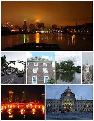 Top: Downtown Providence skyline and the Providence River from the Point Street Bridge; Middle: Federal Hill, University Hall at Brown University, Roger Williams Park, and the First Baptist Church in America; Bottom: WaterFire at Waterplace Park, and the Rhode Island State House. | |
 Flag  Seal | |
| Nickname(s): The Creative Capital, the Renaissance City, the Divine City, PVD, Prov | |
| Motto(s): "What Cheer?"[lower-alpha 1] | |
 Location in Providence County and the state of Rhode Island. | |
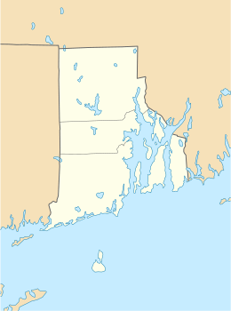 Providence Location within Rhode Island  Providence Location within the United States | |
| Coordinates: 41°49′25″N 71°25′20″W | |
| Country | |
| State | |
| County | Providence |
| Region | New England |
| Settled | 1636 |
| Incorporated (town) | June 1636 |
| Incorporated (city) | November 5, 1832 |
| Founded by | Roger Williams |
| Government | |
| • Type | Mayor-Council |
| • Mayor | Jorge Elorza (D) |
| • Body | Providence City Council |
| Area | |
| • State capital city | 53 km2 (20.6 sq mi) |
| • Land | 48 km2 (18.4 sq mi) |
| • Water | 6 km2 (2.2 sq mi) |
| Elevation | 23 m (75 ft) |
| Population (2010) | |
| • State capital city | 178,042 |
| • Estimate (2018)[3] | 179,335 |
| • Rank | US: 134th |
| • Density | 3,736.0/km2 (9,676.2/sq mi) |
| • Urban | 1,190,956 (US: 39th) |
| • Metro | 1,604,291 (US: 38th) |
| Time zone | UTC−5 (Eastern Time Zone) |
| • Summer (DST) | UTC−4 (EDT) |
| ZIP Codes | 02901–02912, 02918, 02919, 02940 |
| Area code | 401 |
| FIPS code | 44-59000[4] |
| GNIS feature ID | 1219851[5] |
| Website | www |
Providence was one of the first cities in the country to industrialize and became noted for its textile manufacturing and subsequent machine tool, jewelry, and silverware industries.[7][8] Today, the city of Providence is home to eight hospitals and seven institutions of higher learning which have shifted the city's economy into service industries, though it still retains some manufacturing activity.
The city is the third-most-populous city in New England after Boston and Worcester, Massachusetts.
History

Providence was settled in June 1636 by Roger Williams and grew into one of the original Thirteen Colonies. Williams was compelled to leave Massachusetts Bay Colony due to his differing religious views, and he and others established Providence Plantations. This settlement merged with others to become the Colony of Rhode Island and Providence Plantations, and it was a refuge for persecuted religious dissenters from the beginning.[9]
Providence Plantations was burned to the ground in March 1676 by the Narragansetts during King Philip's War, despite the good relations between Williams and the sachems with whom the United Colonies of New England were waging war. Later in the year, the Rhode Island legislature formally rebuked the other colonies for provoking the war.[10]
Providence residents were among the first Patriots to spill blood in the lead-up to the American Revolutionary War during the Gaspee Affair of 1772,[9] and Rhode Island was the first of the Thirteen Colonies to renounce its allegiance to the British Crown on May 4, 1776.[11] It was also the last of the Thirteen States to ratify the United States Constitution on May 29, 1790, once assurances were made that a Bill of Rights would become part of the Constitution.[12]
Following the war, Providence was the country's ninth-largest city[lower-alpha 2][9] with 7,614 people. The economy shifted from maritime endeavors to manufacturing, in particular machinery, tools, silverware, jewelry, and textiles. By the start of the 20th century, Providence hosted some of the largest manufacturing plants in the country, including Brown & Sharpe, Nicholson File, and Gorham Manufacturing Company.
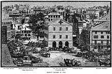
Providence residents ratified a city charter in 1831 as the population passed 17,000.[9] The seat of city government was located in the Market House[14] in Market Square from 1832 to 1878, which was the geographic and social center of the city. The city offices outgrew this building, and the City Council resolved to create a permanent municipal building in 1845.[14] The city offices moved into the Providence City Hall in 1878.

Local politics split over slavery during the American Civil War, as many had ties to Southern cotton and the slave trade. Despite ambivalence concerning the war, the number of military volunteers routinely exceeded quota, and the city's manufacturing proved invaluable to the Union. Providence thrived after the war, and waves of immigrants brought the population from 54,595 in 1865 to 175,597 by 1900.[9]
By the early 1900s, Providence was one of the wealthiest cities in the United States.[15] Immigrant labor powered one of the nation's largest industrial manufacturing centers.[15] Providence was a major manufacturer of industrial products, from steam engines to precision tools to silverware, screws, and textiles. Giant companies were based in or near Providence, such as Brown & Sharpe, the Corliss Steam Engine Company, Babcock & Wilcox, the Grinnell Corporation, the Gorham Manufacturing Company, Nicholson File, and the Fruit of the Loom textile company.[15]
From 1975 until 1982, $606 million of local and national community development funds were invested throughout the city. In the 1990s, the city pushed for revitalization, realigning the north-south railroad tracks, removing the huge rail viaduct that separated downtown from the capitol building, uncovering and moving the rivers (which had been covered by paved bridges) to create Waterplace Park and river walks along the rivers' banks, and constructing the Fleet Skating Rink (now the Alex and Ani City Center)[16] and the Providence Place Mall.[9]
Despite new investment, poverty remains an entrenched problem. Approximately 27.9 percent of the city population is living below the poverty line.[17] Recent increases in real estate values further exacerbate problems for those at marginal income levels, as Providence had the highest rise in median housing price of any city in the United States from 2004 to 2005.[18]
Geography
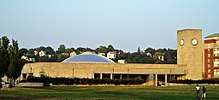
.jpg)
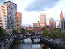
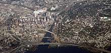
The Providence city limits enclose a small geographical region with a total area of 20.5 square miles (53 km2); 18.5 square miles (48 km2) of it is land and the remaining 2.1 square miles (5.4 km2) is water (roughly 10%). Providence is located at the head of Narragansett Bay, with the Providence River running into the bay through the center of the city,[19] formed by the confluence of the Moshassuck and Woonasquatucket Rivers. The Waterplace Park amphitheater and riverwalks line the river's banks through downtown.
Providence is one of many cities claimed to be founded on seven hills like Rome. The more prominent hills are: Constitution Hill (near downtown), College Hill (east of the Providence River), and Federal Hill (west of downtown and containing New England's largest Italian district outside of Massachusetts). The other four are: Tockwotten Hill at Fox Point, Smith Hill (where the State House is located), Christian Hill at Hoyle Square (junction of Cranston and Westminster Streets), and Weybosset Hill at the lower end of Weybosset Street, which was leveled in the early 1880s.[20]
Neighborhoods

Providence has 25 official neighborhoods, though these neighborhoods are often grouped together and referred to collectively:[21][22]
- The East Side is a region comprising the neighborhoods of Blackstone, Hope (aka Summit), Mount Hope, College Hill, Wayland, and Fox Point.
- The Jewelry District describes the area enclosed by I-95, the old I-195, and the Providence River. The city has made efforts to rename this area the Knowledge District to reflect the area's newly developing life sciences and technology-based economy.[23][24]
- The North End is formed by the concatenation of the neighborhoods of Charles, Wanskuck, Smith Hill, Elmhurst, and Mount Pleasant.
- The South Side (or South Providence) consists of the neighborhoods of Elmwood, Lower South Providence, Upper South Providence, Washington Park, and the West End.
- West Broadway is an officially recognized neighborhood with its own association. It overlaps with the southern half of Federal Hill and the northern part of the West End.[25]
Cityscape

The city of Providence is geographically very compact, characteristic of eastern seaboard cities that developed prior to use of the automobile. It is among the most densely populated cities in the country. For this reason, Providence has the eighth-highest percentage of pedestrian commuters.[26][27] The street layout is irregular; more than one thousand streets (a great number for the city's size) run haphazardly, connecting and radiating from traditionally bustling places such as Market Square.[28]
Downtown Providence has numerous 19th-century mercantile buildings in the Federal and Victorian architectural styles, as well as several post-modern and modernist buildings located throughout the area. In particular, a fairly clear spatial separation appears between the areas of pre-1980s development and post-1980s development. West Exchange Street and Exchange Terrace serve as rough boundaries between the two.
The newer area, sometimes called "Capitol Center",[29] includes Providence Place Mall (1999), the Omni Providence Hotel (1993) and The Residences Providence (2007), GTECH Corporation (2006), Waterplace Towers condominiums (2007), and Waterplace Park (1994). The area tends toward newer development, since much of it is land reclaimed in the 1970s from a mass of railroad tracks referred to colloquially as the "Chinese Wall".[30] This part of Downtown is characterized by open spaces, wide roads, and landscaping.
The historic part of downtown has many streetscapes that look as they did 80 years ago. Many of the state's tallest buildings are found here. The largest structure at 426 feet (130 m) is the art deco-styled Industrial National Bank Building (formerly Industrial Trust Tower).[31] By contrast, nearby to it is the second tallest One Financial Plaza, designed in modern taut-skin cladding, constructed a half-century later.[32] In between the two is 50 Kennedy Plaza. The Textron Tower is also a core building to the modest Providence skyline. Downtown is also the home of the Providence Biltmore and Westminster Arcade, the oldest enclosed shopping mall in the U.S., built in 1828.[33]
The city's southern waterfront, away from the downtown core, is the location of many oil tanks, a docking station for a ferry boat, a non-profit sailing center, bars, strip clubs, and power plants. The Russian Submarine Museum was located here until 2008, when the submarine sank in a storm and was declared a loss. The Fox Point Hurricane Barrier is also found here, built to protect Providence from storm surge like that which it endured in the 1938 New England Hurricane and again in 1954 from Hurricane Carol.[34]
The majority of the cityscape comprises abandoned and revitalized industrial mills, double- and triple-decker housing (though row houses are rare, found so commonly in other Northeast cities),[35] a small number of high-rise buildings (predominantly for housing the elderly), and single family homes. Interstate 95 serves as a physical barrier between the city's commercial core and neighborhoods such as Federal Hill and the West End.
 Perspective of Westminster Street
 Downtown Providence at Burnside Park
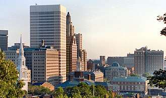 The Downtown Providence skyline, viewed from College Hill on the city's East Side
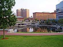 Waterplace Park
 Intersection of Weybosset and Westminster Streets with Turk's Main Building on the left
 Downtown Weybosset Street
Climate
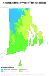
Providence has a humid continental climate (Köppen climate classification Dfa) bordering a humid subtropical climate with hot summers, cold winters, and high humidity year-round. The USDA places the city in hardiness zone 6b, with the suburbs in zones 6a – 7b.[36] The influence of the Atlantic Ocean keeps the state of Rhode Island[37] warmer than many inland locales in New England.[38][39] January is the coldest month with a daily mean of 29.2 °F (−1.6 °C) and low temperatures dropping to 10 °F (−12 °C) or lower an average of 11 days per winter,[40] while July is the warmest month with a daily mean of 73.5 °F (23.1 °C) and highs rising to 90 °F (32 °C) or higher an average of 10 days per summer.[40] Extremes range from −17 °F or −27.2 °C on February 9, 1934 to 104 °F or 40 °C on August 2, 1975;[41] the record cold daily maximum is 1 °F (−17.2 °C) on February 5, 1918, while the record warm daily minimum is 80 °F (26.7 °C) on June 6, 1925.[40] Temperature readings of 0 °F or −17.8 °C or lower are uncommon in Providence and generally occur once every several years. The year which had the most days with a temperature reading of zero degrees or lower was 2015 with eight days total—one day in January and seven days in February.[40] Conversely, temperature readings of 100 °F or 37.8 °C or higher are even rarer, and the year with the most days in this category was 1944 with three days, all of which were in August.[40]
Monthly precipitation in Providence ranges from a high of 4.43 inches (112.5 mm) in March to a low of 3.17 inches (80.5 mm) in July.[41] In general, precipitation levels are slightly less in the summer months than the winter months, when Nor'easters can cause significant snowfall and blizzard conditions. Hurricanes are not frequent in coastal New England, although Providence's location at the head of Narragansett Bay makes it vulnerable to them.
| Climate data for Providence, Rhode Island (T. F. Green Airport), 1981–2010 normals,[lower-alpha 3] extremes 1904–present[lower-alpha 4] | |||||||||||||
|---|---|---|---|---|---|---|---|---|---|---|---|---|---|
| Month | Jan | Feb | Mar | Apr | May | Jun | Jul | Aug | Sep | Oct | Nov | Dec | Year |
| Record high °F (°C) | 69 (21) |
72 (22) |
90 (32) |
98 (37) |
96 (36) |
98 (37) |
102 (39) |
104 (40) |
100 (38) |
88 (31) |
81 (27) |
77 (25) |
104 (40) |
| Mean maximum °F (°C) | 57.2 (14.0) |
58.3 (14.6) |
68.4 (20.2) |
80.3 (26.8) |
86.2 (30.1) |
91.3 (32.9) |
94.5 (34.7) |
92.3 (33.5) |
87.0 (30.6) |
78.1 (25.6) |
70.0 (21.1) |
60.8 (16.0) |
96.2 (35.7) |
| Average high °F (°C) | 37.4 (3.0) |
40.3 (4.6) |
47.8 (8.8) |
58.6 (14.8) |
68.4 (20.2) |
77.5 (25.3) |
82.8 (28.2) |
81.4 (27.4) |
74.2 (23.4) |
63.3 (17.4) |
53.2 (11.8) |
42.3 (5.7) |
60.6 (15.9) |
| Average low °F (°C) | 21.0 (−6.1) |
23.6 (−4.7) |
30.0 (−1.1) |
39.6 (4.2) |
48.6 (9.2) |
58.4 (14.7) |
64.2 (17.9) |
63.2 (17.3) |
55.3 (12.9) |
43.9 (6.6) |
35.7 (2.1) |
26.3 (−3.2) |
42.5 (5.8) |
| Mean minimum °F (°C) | 2.9 (−16.2) |
7.7 (−13.5) |
14.7 (−9.6) |
28.8 (−1.8) |
36.9 (2.7) |
47.1 (8.4) |
55.0 (12.8) |
52.4 (11.3) |
42.2 (5.7) |
31.2 (−0.4) |
21.7 (−5.7) |
10.4 (−12.0) |
0.9 (−17.3) |
| Record low °F (°C) | −13 (−25) |
−17 (−27) |
1 (−17) |
11 (−12) |
29 (−2) |
39 (4) |
48 (9) |
40 (4) |
32 (0) |
20 (−7) |
6 (−14) |
−12 (−24) |
−17 (−27) |
| Average precipitation inches (mm) | 3.86 (98) |
3.29 (84) |
5.01 (127) |
4.36 (111) |
3.55 (90) |
3.64 (92) |
3.29 (84) |
3.60 (91) |
3.92 (100) |
3.93 (100) |
4.51 (115) |
4.22 (107) |
47.18 (1,198) |
| Average snowfall inches (cm) | 9.0 (23) |
8.5 (22) |
5.5 (14) |
0.6 (1.5) |
0 (0) |
0 (0) |
0 (0) |
0 (0) |
0 (0) |
0 (0) |
1.5 (3.8) |
8.7 (22) |
33.8 (86) |
| Average precipitation days (≥ 0.01 in) | 10.9 | 9.7 | 11.9 | 11.3 | 12.0 | 10.9 | 9.4 | 9.0 | 8.7 | 9.4 | 10.1 | 11.6 | 124.9 |
| Average snowy days (≥ 0.1 in) | 5.7 | 4.6 | 3.5 | 0.4 | 0 | 0 | 0 | 0 | 0 | 0 | 0.6 | 3.9 | 18.7 |
| Average relative humidity (%) | 63.9 | 63.0 | 62.9 | 61.4 | 66.6 | 70.1 | 71.0 | 72.5 | 73.0 | 70.2 | 68.9 | 67.0 | 67.5 |
| Mean monthly sunshine hours | 171.7 | 172.6 | 215.6 | 225.1 | 254.9 | 274.1 | 290.6 | 262.8 | 233.0 | 208.7 | 148.0 | 148.6 | 2,605.7 |
| Percent possible sunshine | 58 | 58 | 58 | 56 | 57 | 60 | 63 | 61 | 62 | 61 | 50 | 52 | 58 |
| Average ultraviolet index | 1 | 2 | 4 | 6 | 7 | 8 | 8 | 8 | 6 | 4 | 2 | 1 | 5 |
| Source: Weather Atlas [43] | |||||||||||||
| Climate data for Providence | |||||||||||||
|---|---|---|---|---|---|---|---|---|---|---|---|---|---|
| Month | Jan | Feb | Mar | Apr | May | Jun | Jul | Aug | Sep | Oct | Nov | Dec | Year |
| Average sea temperature °F (°C) | 41.4 (5.2) |
38.1 (3.4) |
38.7 (3.8) |
44.1 (6.7) |
50.9 (10.5) |
59.6 (15.3) |
67.0 (19.4) |
69.3 (20.7) |
66.7 (19.3) |
61.6 (16.4) |
54.2 (12.3) |
47.7 (8.8) |
53.3 (11.8) |
| Source: Weather Atlas [43] | |||||||||||||
Demographics
| Historical population | |||
|---|---|---|---|
| Census | Pop. | %± | |
| 1790 | 6,380 | — | |
| 1800 | 7,614 | 19.3% | |
| 1810 | 10,070 | 32.3% | |
| 1820 | 11,767 | 16.9% | |
| 1830 | 16,833 | 43.1% | |
| 1840 | 23,171 | 37.7% | |
| 1850 | 41,513 | 79.2% | |
| 1860 | 50,666 | 22.0% | |
| 1870 | 68,904 | 36.0% | |
| 1880 | 104,857 | 52.2% | |
| 1890 | 132,146 | 26.0% | |
| 1900 | 175,597 | 32.9% | |
| 1910 | 223,326 | 27.2% | |
| 1920 | 237,595 | 6.4% | |
| 1930 | 252,981 | 6.5% | |
| 1940 | 253,504 | 0.2% | |
| 1950 | 248,674 | −1.9% | |
| 1960 | 207,498 | −16.6% | |
| 1970 | 179,213 | −13.6% | |
| 1980 | 156,804 | −12.5% | |
| 1990 | 160,728 | 2.5% | |
| 2000 | 173,618 | 8.0% | |
| 2010 | 178,042 | 2.5% | |
| Est. 2018 | 179,335 | [3] | 0.7% |
| Largest Cities and Other Urban Places in the United States: 1790 to 1990.[44] 2018 Estimate[45] | |||
| Demographic profile | 2010[46] | 1990[47] | 1970[47] | 1950[47] |
|---|---|---|---|---|
| White | 49.8% | 69.9% | 90.0% | 96.5% |
| —Non-Hispanic | 37.6% | 64.5% | 89.5%[48] | N/A |
| Black or African American | 16.0% | 14.8% | 8.9% | 3.3% |
| Hispanic or Latino (of any race) | 38.1% | 15.5% | 0.8%[48] | N/A |
| Asian | 6.4% | 5.9% | 0.5% | 0.1% |
As of the census[4] of 2000, the population consisted of 173,618 people, 162,389 households, and 35,859 families. The population density was 9,401.7 inhabitants per square mile (3,629.4/km²), characteristic of other small cities in New England such as New Haven, Connecticut; Springfield, Massachusetts; and Hartford, Connecticut.[49] Its population peaked in the 1940s, just prior to the nationwide period of rapid suburbanization.
Providence has a racially and ethnically diverse population. In 2010, white Americans formed 49.8% of the population, including a sizable white Hispanic community. Non-Hispanic whites were 37.6% of the total population,[46] down from 89.5% in 1970.[47] Providence has had a substantial Italian population since the start of the 20th century, with 14% of the population claiming Italian ancestry.[50] Italian influence manifests itself in Providence's Little Italy in Federal Hill.[51] Irish immigrants have also had considerable influence on the city's history, with 8% of residents claiming Irish heritage.[52] The city also has a sizeable Jewish community, estimated at 10,500 in 2012 or roughly 5% of the city's population.[53]
.png)
In 2010, people of Hispanic or Latino origin composed 38.1% of the city's population and currently form a majority of city public school students.[46][54] The majority of Hispanics in Providence are of Dominican descent, having one of the largest Dominican populations in the United States. Other Hispanic groups present in large numbers are Puerto Ricans and Guatemalans. Hispanics are most concentrated in the neighborhoods of Elmwood, the West End, and Upper and Lower South Providence.[55] The city elected its first Hispanic mayor in 2010, Dominican-American Angel Taveras.
African Americans constitute 16%[46] of the city's population, with their greatest concentrations found in Mount Hope and the Upper and Lower South Providence neighborhoods.[56][57] Asians are 6% of Providence's population and have enclaves scattered throughout the city. The largest Asian groups are Cambodians (1.7%), Chinese (1.1%), Asian Indians (0.7%), Laotians (0.6%), and Koreans (0.6%).[57] Another 6% of the city has multiracial ancestry. American Indians and Pacific Islanders make up the remaining 1.3%. Liberians compose 0.4% of the population;[50] the city is home to one of the largest Liberian immigrant populations in the country.[58]
Providence has a considerable community of immigrants from various Portuguese-speaking countries, especially Portugal, Brazil, and Cape Verde, living mostly in the areas of Washington Park and Fox Point.[59][60][61] Portuguese is the city's third-largest European ethnicity, after Italian and Irish, at 4% of the population; Cape Verdeans compose 2%.[50]
The Providence metropolitan area includes Providence, Fall River, Massachusetts, and Warwick, and is estimated to have a population of 1,622,520. In 2006, this area was officially added to the Boston Combined Statistical Area (CSA), the sixth-largest CSA in the country. In the last 15 years, Providence has experienced a sizable growth in its under-18 population. The median age of the city is 28 years, while the largest age cohort is 20- to 24-year-olds, owing to the city's large student population.[46][62]
The per capita income as of the 2000 census was $15,525, which is well below both the state average of $29,113[63] and the national average of $21,587.[64] The median income for a household was $26,867, and the median income for a family in Providence was $32,058, according to the 2000 census. The city has one of the highest rates of poverty in the nation with 29.1% of the population and 23.9% of families living below the poverty line in 2000, the largest concentrations being found in the city's Olneyville, and Upper and Lower South Providence areas.[17][65] Poverty has affected children at a disproportionately higher rate, with 40.1% of those under the age of 18 living below the poverty line, concentrated west of downtown in the neighborhoods of Hartford, Federal Hill, and Olneyville.[65]
Crime
| Providence | |
|---|---|
| Crime rates* (2013) | |
| Violent crimes | |
| Homicide | 12 |
| Rape | 97 |
| Robbery | 365 |
| Aggravated assault | 641 |
| Total violent crime | 1,115 |
| Property crimes | |
| Burglary | 1,828 |
| Larceny-theft | 5,184 |
| Motor vehicle theft | 962 |
| Arson | 22 |
| Total property crime | 7,974 |
Notes *Number of reported crimes per 100,000 population. 2013 population: 178,887 Source: 2013 FBI UCR Data | |
Compared to the national average, Providence has an average rate of violent crime and a higher rate[66] of property crime per 100,000 inhabitants.[67] In 2010, there were 15 murders, down from 24 in 2009.[68] In 2010, Providence fared better regarding violent crime than most of its peer cities. Springfield, Massachusetts has approximately 20,000 fewer residents than Providence but reported 15 murders in 2009, the same number of homicides as Providence but a slightly higher rate per capita.[69] The police chief asserted that Providence's violence was not stranger-to-stranger, but relationship-driven.[70] The pattern of violent crime was highly specific by neighborhood, with the vast majority of the murders taking place in the poorer sections of Providence such as Olneyville, Elmwood, South Providence, and the West End.[71]
Economy
Around 1830, Providence had manufacturing industries in metals, machinery, textiles, jewelry, and silverware. Manufacturing has declined since, but the city is still one of the largest centers for jewelry and silverware design and manufacturing. Services also make up a large portion of the city's economy, in particular education, healthcare, and finance. Providence also is the site of a sectional center facility (SCF), a regional hub for the U.S. Postal Service.[72] It is the capital of Rhode Island, so the city's economy additionally consists of government services.


Prominent companies headquartered in Providence include Fortune 500 Textron, an advanced technologies industrial conglomerate; United Natural Foods, a distributor of natural and organic foods; Fortune 1000 Nortek Incorporated; Gilbane, a construction and real estate company; and GTECH Corporation, which recently moved its world headquarters to downtown Providence.[74] Citizens Bank is also headquartered in Providence and is the 15th largest bank in the country.[75][76]
The city is home to the Rhode Island Convention Center, which opened in December 1993.[77] Along with a hotel, the convention center is connected to the Providence Place Mall, a major retail center, through a skywalk.[77] The Port of Providence is the second largest deep-water seaport in New England.[78] [79] It handles cargos such as cement, chemicals, heavy machinery, petroleum, and scrap metal. Providence is also home to some of toy manufacturer Hasbro's business operations, although their headquarters are in Pawtucket.
Top employers
According to the City's 2014 Comprehensive Annual Financial Report,[80] the top twenty employers in the city are:
| # | Employer | # of Employees | % of Total city employment |
|---|---|---|---|
| 1 | Brown University | 4,600 | 4.30% |
| 2 | Rhode Island Hospital | 4,200 | 3.93% |
| 3 | Lifespan | 1,990 | 1.86% |
| 4 | Women & Infants Hospital | 1,800 | 1.68% |
| 5 | Roger Williams Medical Center | 1,470 | 1.38% |
| 6 | Miriam Hospital | 1,263 | 1.18% |
| 7 | Belo Corp/Providence Journal | 870 | 0.81% |
| 8 | Mars 2000 | 850 | 0.80% |
| 9 | Providence College | 799 | 0.75% |
| 10 | AAA Southern New England | 700 | 0.66% |
| 11 | Johnson & Wales University | 700 | 0.66% |
| 12 | Butler Hospital | 699 | 0.65% |
| 13 | H. Carr & Sons Inc. | 500 | 0.47% |
| 14 | National Grid | 450 | 0.42% |
| 15 | Employment 2000 | 400 | 0.37% |
| 16 | Verizon | 400 | 0.37% |
| 17 | Gilbane Building Co. | 400 | 0.37% |
| 18 | Walmart | 350 | 0.33% |
| 19 | Jewel Case Corp. | 300 | 0.28% |
| 20 | Nordstrom | 300 | 0.28% |
| 21 | Target Corporation | 200 | 0.35% |
Government
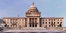
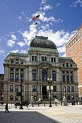
As the state capital, Providence houses the Rhode Island General Assembly, as well as the offices of the Governor and the Lieutenant Governor in the Rhode Island State House. The city itself has a Mayor-council government. The Providence City Council consists of 15 councilors, one for each of the city's wards, who enact ordinances and pass an annual budget. Providence also has probate and superior courts. The U.S. District Court for the District of Rhode Island is located downtown across from Providence City Hall adjacent to Kennedy Plaza.
In November 2002, David N. Cicilline was elected mayor of Providence, becoming the first openly gay mayor of a United States state capital.[81]
The city's first Latino mayor was Angel Taveras, who assumed office on January 3, 2011.[82] Current mayor Jorge Elorza succeeded him on January 5, 2015.[83]

The headquarters of the city's fire and police departments is a 130,000 square foot, steel frame Public Safety Complex on Washington Street near Interstate I-95. The building was dedicated in 2002 by former Mayor Vincent Cianci Jr.[84]
Education
Postsecondary

The main campuses of five of Rhode Island's colleges and universities are in Providence (city proper):
- Brown University, an Ivy League university and one of nine colonial colleges in the nation
- Johnson & Wales University
- Providence College
- Rhode Island College, the state's oldest public college
- Rhode Island School of Design (RISD)
In addition, the Community College of Rhode Island, Roger Williams University, and University of Rhode Island have satellite campuses in the city. Between these schools, the number of post-secondary students is approximately 44,000.[85] Higher education exerts a considerable presence in the city's politics and economy, compounded by the fact that Brown University is the city's second-largest employer.[79]
Private and charter schools
There are several private schools in the city's East Side, including Moses Brown, the Lincoln School, and the Wheeler School. La Salle Academy is located in the North End (Elmhurst neighborhood), near Providence College. The public charter schools Time Squared Academy High School (K-12) and Textron Chamber of Commerce (9–12) are funded by GTECH Corporation and Textron respectively.[86] In addition, the city's South Side houses Community Preparatory School, a private school serving primarily low-income students in grades 3–8.[87] There are two separate centers for students with special needs.[88]
Public schools
The Providence Public School District serves about 30,000 students from pre-Kindergarten to grade 12. The district has 25 elementary schools, nine middle schools, and thirteen high schools. The Providence Public School District features magnet schools at the middle and high school level, Nathanael Greene and Classical respectively. The overall graduation rate as of 2007 is 70.1%,[89] which is close to the statewide rate of 71% and the national average of 70%.[90] Rhode Island also operates two public schools in Providence.
Culture

Much of Providence culture is synonymous with the culture of Rhode Island as a whole. Like the state, the city has a non-rhotic accent that can be heard on local media. Providence also shares Rhode Island's affinity for coffee, with the most coffee and doughnut shops per capita of any city in the country.[91] Providence is also reputed to have the highest number of restaurants per capita of major U.S. cities,[92] many of which are founded or staffed by Johnson & Wales University graduates.[93]

Providence has several ethnic neighborhoods, notably Federal Hill and the North End (Italian),[94] Fox Point (Portuguese),[95] West End (mainly Central American and Asians),[96] and Smith Hill (Irish with miscellaneous enclaves of other groups).[97] There are also many dedicated community organizations and arts associations located in the city.[98]
The city gained the reputation as one of the most active and growing gay and lesbian communities in the Northeast.[99][100] The rate of reported gay and lesbian relationships is 75% higher than the national average,[101] and Providence has been named among the "Best Lesbian Places to Live".[100] Former mayor David Cicilline won his election running as an openly gay man,[81] Former Mayor Cianci instituted the position of Mayor's Liaison to the Gay and Lesbian community in the 1990s.[100] and Providence is home to the largest gay bathhouse in New England.[102]
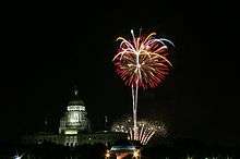
During the summer months, the city regularly hosts WaterFire, an environmental art installation that consists of about 100 bonfires which blaze just above the surface of the three rivers that pass through the middle of downtown Providence.[103] There are multiple Waterfire events that are accompanied by various pieces of classical and world music. The public art displays change on a regular basis, most notably the sculptures.
The city is also the home of the Tony Award-winning theater group Trinity Repertory Company, the Providence Black Repertory Company, and the Rhode Island Philharmonic Orchestra,[104] as well as groups such as The American Band, once associated with noted American composer David Wallis Reeves. Providence is also the home of several performing arts centers, such as the Veterans Memorial Auditorium, the Providence Performing Arts Center, and Festival Ballet Providence. The city's underground music is centered on artist-run spaces such as the now-defunct Fort Thunder and is known in underground music circles.[105] Providence is also home to the Providence Improv Guild, an improvisational theatre that has weekly performances and offers improv and sketch comedy classes.[106]
Sites of interest
Providence is home to a 1,200-acre (4.9 km2) park system,[107] notably Waterplace Park and Riverwalk, Roger Williams Park, Roger Williams National Memorial, and Prospect Terrace Park. Prospect Terrace Park features expansive views of the downtown area, as well as a 15-foot tall granite statue of Roger Williams gazing over the city. As one of the first cities in America, Providence contains many historic buildings, while the East Side neighborhood in particular includes the largest contiguous area of buildings listed on the National Register of Historic Places in the U.S., with many pre-revolutionary houses.[108]
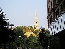
The East Side is also home to the First Baptist Church in America, which was founded by Williams in 1638, as well as the Old State House which served as the state's capitol from 1762 to 1904.[109] Nearby is Roger Williams National Memorial. The dome of the State House is the fourth-largest self-supporting marble dome in the world and the second-largest marble dome after St. Peter's Basilica in Rome.[110] The Westminster Arcade is the oldest enclosed shopping center in the U.S.[111][112]
The Rhode Island School of Design Museum contains the 20th-largest collection in the United States.[113] The Providence Athenæum is the fourth oldest library in the United States, in addition to the Providence Public Library and the nine branches of the Providence Community Library.[114] Edgar Allan Poe frequented the library, and met and courted Sarah Helen Whitman at the library.[115] H. P. Lovecraft was also a regular patron.[116]
The Alex and Ani City Center (formerly the Bank of America Skating Center and Fleet Skating Center) is located near Kennedy Plaza in the downtown district, connected by pedestrian tunnel to Waterplace Park, a cobblestone and concrete park below street traffic that abuts Providence's three rivers.[117][118][16][119]
The southern part of the city is home to the famous roadside attraction Nibbles Woodaway (also known as the "Big Blue Bug"), the world's largest termite.[120] Roger Williams Park contains a zoo, a botanical center, and the Museum of Natural History and Planetarium.[121]
Another well-known site is the Providence Biltmore Hotel located downtown near Kennedy Plaza, a historic location built in 1922.[122] The hotel closed in 1974; it was added to the National Register of Historic Places in 1977, and it reopened in 1979.
Sports

The city is home to the American Hockey League team Providence Bruins, which plays at the Dunkin' Donuts Center (formerly the Providence Civic Center). From 1926 to 1972, the AHL's Providence Reds (renamed the Rhode Island Reds in their last years)[124] played at the Rhode Island Auditorium. In 1972, the team relocated to the Providence Civic Center, where they played until moving to Binghamton, New York, in 1977.
The city has two rugby teams, the Rugby Union team Providence Rugby Football Club, and the Semi-Professional Rugby league team The Rhode Island Rebellion, which play at Classical High School. In 2013 the Rebellion finished the USA Rugby League (USARL) regular season in third place. Their playoff run took them to the USARL Semi-Finals, the first time the Rebellion made the playoffs in its short three-year history.
The Providence Hurling Club was founded in 2015 by Michael Kennelly, David O'Connor, and Michael Walsh. The club is part of the Boston Gaelic Athletic Association (GAA). Since their inauguration the team has captured three cups. The league comprises Worcester, Hartford, Portsmouth, and Concord. UConn Huskies also put forth a team in various play and other university teams are in the process of being established. Home games are played at a pitch located at 50 Obediah Brown Road behind Pleasant View Elementary School. In November 2018, for the first time playoffs were hosted in Providence and Providence took the cup by defeating Worcester.
The NFL's New England Patriots and MLS's New England Revolution play in Foxborough, Massachusetts, which is situated halfway between Providence and Boston. Providence was formerly home to two major league franchises: the NFL's Providence Steam Roller in the 1920s and 1930s, and the NBA's Providence Steamrollers in the 1940s. The Rhode Island Auditorium also hosted 29 of the 49 boxing fights of Rocky Marciano.[125]
The city's defunct baseball team, the Providence Grays, competed in the National League from 1879 through 1885. The team defeated the New York Metropolitans in baseball's first successful "world championship series" in 1884.[126] In 1914, after the Boston Red Sox purchased Babe Ruth from the then-minor league Baltimore Orioles, the team prepared Ruth for the major leagues by sending him to finish the season playing for a minor league team in Providence that was also known as the Grays. Today, professional baseball is offered by the Pawtucket Red Sox, the AAA affiliate of the Boston Red Sox, which plays in nearby Pawtucket. Most baseball fans—along with the local media—tend to follow the Boston Red Sox.[127]
Major colleges and universities fielding NCAA Division I athletic teams are Brown University and Providence College. The latter is a member of the Big East Conference. Much local hype is associated with games between these two schools or the University of Rhode Island.
Providence has also hosted the alternative sports event Gravity Games from 1999 to 2001, and was also the first host of ESPN's X Games, known in its first edition as the Extreme Games, in 1995. Providence has its own roller derby league. Formed in 2004, it currently has four teams: the Providence Mob Squad, the Sakonnet River Roller Rats, the Old Money Honeys, and the Rhode Island Riveters. Providence is also home to the headquarters of the American Athletic Conference (The American).[128]
Infrastructure
Health and medicine
Providence is home to eight hospitals, most prominently Rhode Island Hospital, the largest general acute care hospital in the state. It is also the Level I Trauma Center for Rhode Island, Southeastern Massachusetts and parts of Connecticut.[129] The hospital is in a complex along I-95 that includes Hasbro Children's Hospital and Women and Infants Hospital. The city is also home to the Roger Williams Medical Center, St. Joseph Hospital For Specialty Care (a division of St. Joseph Health Services Of Rhode Island), The Miriam Hospital, a major teaching affiliate associated with the Alpert Medical School of Brown University, as well as a VA medical center.
The Rhode Island Blood Center has its main headquarters in Providence. Since 1979, the Rhode Island Blood Center has been the sole organization in charge of blood collection and testing and distribution of blood products to 11 hospitals in Rhode Island.
Transportation
Providence is served by T. F. Green Airport in Warwick, and general aviation fields also serve the region. Massport has been promoting T. F. Green as an alternative to Boston's Logan International Airport because of over-crowding.[130] Providence Station is located between the Rhode Island State House and the downtown district and is served by Amtrak[131] and MBTA Commuter Rail services, with a commuter rail route running north to Boston and south to T.F. Green Airport and Wickford Junction.[132][133] Approximately 2,400 passengers pass through the station per day.[134][135]
I-95 runs from north to south through Providence; I-195 connects the city to eastern Rhode Island and southeastern Massachusetts, including New Bedford, Massachusetts and Cape Cod. I-295 encircles Providence, while RI 146 provides a direct connection with Worcester, Massachusetts. The city began the long-term project Iway in 2007 to move I-195 for safety reasons, to free up land, and to reunify the Jewelry District with downtown Providence, which had been separated by the highway.[136] The project was estimated to cost $610 million. In 2019, a pedestrian bridge opened spanning the Providence River and connecting the east and west sides of downtown. It was built on the granite piers of the old Route 195 bridge.[137]
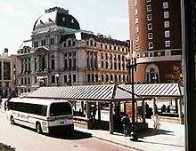
Kennedy Plaza in downtown Providence serves as a transportation hub for local public transit as well as a departure point for Peter Pan Bus Lines[138] and Greyhound Lines.[139] Public transit is managed by Rhode Island Public Transit Authority (RIPTA).[140] Through RIPTA alone, Kennedy Plaza serves more than 71,000 people a day.[141] The majority of the area covered by RIPTA is served by traditional buses, but RIPTA also runs a "Rapid Bus", the R-Line which connects the suburbs of Pawtucket and Cranston with downtown Providence. Of particular note is the East Side Trolley Tunnel running under College Hill, whose use is reserved for RIPTA buses. RIPTA also operates the Providence LINK, a system of tourist trolleys in downtown Providence. From 2000 to 2008, RIPTA operated a seasonal ferry to Newport, Rhode Island between May and October, but SeaStreak began operating that ferry route in 2016.[142] In 2018, RIPTA began construction of the "Downtown Transit Connector", an upgraded BRT service to run from Providence Station to the Hospital District.[143]
Utilities
Electricity and natural gas are provided by National Grid.[144] Providence Water is responsible for the distribution of drinking water, ninety percent of which comes from the Scituate Reservoir about ten miles (16 km) west of downtown, with contributions coming from four smaller bodies of water. Drinking water in Providence has been rated among the highest quality in the country.[145][146][147][148]
Sister cities
As of 2016, Providence had five sister cities: [149]


See also
- List of people from Providence, Rhode Island
- List of tallest buildings in Providence
- National Register of Historic Places listings in Providence, Rhode Island
- Neighborhoods in Providence
Notes
- This motto may appear rhetorical, but it was an earnest expression from the traditional account of Roger Williams' arrival in Rhode Island with settlers William Harris, John Smith, Joshua Verin, Thomas Angell, and Francis Wickes.[1] The party was greeted by a group of Narragansetts, with the description of their exchange:[2]
Not far from that bridge [over the Blackstone] in a little cove is the famous "Slate Rock," on which it is said that Roger Williams first landed after his tedious and painful flight from the persecutions of his Massachusetts brethren.
As he approached the place he was saluted by some friendly Indians with the peaceful enquiry "What Cheer netop?" netop, meaning friend, a phrase which they had acquired from their intercourse with the English and which was equivalent to the salutation "How are you?" or "What's the news?"... It is this incident which is pictured upon the seal of the city of Providence. - Providence was listed as a town (not a city) by the US Census Bureau until the Census of 1840 because city status in the New England states is conferred by the form of government, not by population. Providence retained the title of ninth-largest settlement until the Census of 1810.
- Mean monthly maxima and minima (i.e. the expected highest and lowest temperature readings at any point during the year or given month) calculated based on data at said location from 1981 to 2010.
- Official records for Providence kept at downtown from November 1904 to May 1932 and at T. F. Green Airport since June 1932.[42]
References
- Bayles, Richard M., ed. (1891). History of Providence County, Rhode Island. 1. New York: W.W. Preston & Co. p. 16.
- Banvard, Joseph (1858). A Guide to Providence River and Narragansett Bay from Providence to Newport. Providence: Coggeshall & Stewart. p. 17.
- "Population and Housing Unit Estimates". Retrieved July 12, 2019.
- "U.S. Census website". United States Census Bureau. Retrieved January 31, 2008.
- "US Board on Geographic Names". United States Geological Survey. October 25, 2007. Retrieved January 31, 2008.
- "Providence: Introduction". Advameg, Inc. Retrieved June 5, 2007.
- "Providence Architecture". brown.edu. Retrieved May 15, 2017.
- Kupperman, Karen Ordahl (June 1995). Providence Island, 1630–1641: The Other Puritan Colony. Cambridge University Press. p. 17. ISBN 0-521-35205-3.
- "Three and One-Half Centuries at a Glance". City of Providence, Rhode Island. May 2002. Archived from the original on January 13, 2006. Retrieved January 17, 2006.
- Allen, Zachariah (April 10, 1876). Bi-centenary of the Burning of Providence in 1676: Defence of the Rhode Island System of Treatment of the Indians, and of Civil and Religious Liberty. An Address Delivered Before the Rhode Island Historical Society. Providence: Providence Publishing Company. Retrieved February 11, 2019.
- "Know Rhode Island, RI Secretary of State". Sos.ri.gov. Retrieved February 26, 2014.
- "Rhode Island Ratification of the U.S. Constitution". Usconstitution.net. January 8, 2010. Retrieved January 26, 2013.
- Cady, John Hutchins (October 1952). "The Providence Market House and its neighborhood" (PDF). Rhode Island History. Rhode Island Historical Society. 11 (4): 97–106. Retrieved April 9, 2015.
- Campbell, Paul. "A Brief History of Providence City Hall". City Archives. City of Providence. Retrieved April 10, 2020.
- Stanton, Mike (2003). The Prince of Providence. New York: Random House. p. 7. ISBN 0-375-75967-0.
- "Alex and Ani City Center". The Providence Rink. Retrieved February 11, 2017.
- "Providence (city), Rhode Island – QuickFacts". US Census Bureau. 2012. Archived from the original on January 27, 2013. Retrieved June 6, 2014.
- "Money Magazine: Best Places to Live: Home Appreciation". Cable News Network LP, LLLP. Retrieved March 6, 2007.
- "Providence: Geography and Climate". Advameg, Inc. Retrieved June 5, 2007.
- Brown, Seth (September 1, 2007). Rhode Island Curiosities: Quirky Characters, Roadside Oddities & Other Offbeat Stuff. Globe Pequot. p. 6. ISBN 978-0-7627-4338-4. Retrieved July 4, 2010.
- "Providence Neighborhoods". City of Providence. Retrieved January 17, 2007.
- "Alternative Neighborhood Names". The Providence Plan. 2007. Archived from the original on September 28, 2007. Retrieved January 31, 2007.
- "Brown University continues Knowledge District expansion, buys building for $6M". Providence Business News. Archived from the original on March 18, 2012. Retrieved May 4, 2011.
- "'Jewelry District,' 'Knowledge District': What's in a name?". Rhode Island news. The Providence Journal Co. Archived from the original on June 13, 2010. Retrieved May 4, 2011 – via projo.com.
- "West Broadway Neighborhood Association". WBNA. Retrieved July 30, 2007.
- "Carfree Database Results". Bikes At Work Inc. Retrieved June 5, 2007. Out of cities over 100,000 in population
- "Carfree Database Results". Bikes At Work Inc. Retrieved June 5, 2007. Out of cities over 100,000 in population
- Albert J. Wright. "History of the State of Rhode Island with Illustrations". USGenWeb Project. Retrieved June 23, 2011.
- Woodward, William McKenzie (2003). PPS/AIAri Guide to Providence Architecture. Providence, Rhode Island: Providence Preservation Society. pp. 303–304. ISBN 0-9742847-0-X.
- Woodward, William McKenzie (2003). PPS/AIAri Guide to Providence Architecture. Providence, Rhode Island: Providence Preservation Society. p. 13. ISBN 0-9742847-0-X.
- "Bank of America Building, Providence". Emporis. 2007. Retrieved January 19, 2007.
- "One Financial Plaza". Emporis. 2006. Retrieved June 5, 2006.
- "Providence Buildings, Real Estate, Architecture, Skyscrapers, and Construction Database". Emporis. 2005. Archived from the original on May 29, 2005. Retrieved November 7, 2005.
- "History: A Rhode Island Tradition". The Providence Biltimore. Archived from the original on October 12, 2007. Retrieved July 11, 2007.
- Woodward, William McKenzie (2003). PPS/AIAri Guide to Providence Architecture. Providence, Rhode Island: Providence Preservation Society. p. 227. ISBN 0-9742847-0-X.
- "USDA Plant Hardiness Zone Map". United States Department of Agriculture. Archived from the original on February 27, 2014. Retrieved June 1, 2014.
- "Rhode Island USDA Plant Hardiness Zone Map". Retrieved November 22, 2010.
- "USDA Plant Hardiness Zone Map". US Department of Agriculture – The United States National Arboretum. March 2, 2006. Archived from the original on March 3, 2015. Retrieved January 19, 2007.
- "Rhode Island ISDA Hardiness Zone Map". growit.com. 2000. Archived from the original on January 7, 2001. Retrieved January 19, 2007.
- "Monthly average temperatures and precipitation". The Weather Channel. Retrieved August 30, 2009.
- ThreadEx
- "Providence, Rhode Island, USA - Monthly weather forecast and Climate data". Weather Atlas. Retrieved July 4, 2019.
- Gibson, Campbell (June 1998). "Population of the 100 Largest Cities and Other Urban Places in the United States: 1790 to 1990". U.S. Census Bureau – Population Division. Archived from the original on March 14, 2007. Retrieved January 17, 2007.
- "Population Estimates". United States Census Bureau. Retrieved June 8, 2018.
- "Providence (city), Rhode Island". State & County QuickFacts. U.S. Census Bureau. Archived from the original on January 27, 2013. Retrieved April 22, 2012.
- "Race and Hispanic Origin for Selected Cities and Other Places: Earliest Census to 1990". U.S. Census Bureau. Archived from the original on August 6, 2012.
- From 15% sample
- "Providence (city) QuickFacts from the US Census Bureau". US Census Bureau. Archived from the original on January 27, 2013. Retrieved January 18, 2007.
- "Providence, Rhode Island". Moving Traffic, Inc. Retrieved April 1, 2009. (Click on People tab)
- "Federal Hill". City of Providence. Retrieved June 7, 2011.
- "Providence—Ancestry & Family History". ePodunk Inc. Archived from the original on October 12, 2007. Retrieved June 19, 2007.
- "Jewish Population in the United States, 2010" (PDF). North American Jewish Data Bank. Archived from the original (PDF) on September 12, 2012. Retrieved October 29, 2012.
- "The Providence Public School Department and The University of Rhode Island Partnership" (PDF). Southern Regional Education Board. p. 2. Archived from the original (PDF) on June 14, 2007. Retrieved June 5, 2007.
- "Geographic Concentration of the Latino Population" (PDF). Archived from the original (PDF) on June 14, 2007.
- "Providence City, Rhode Island". US Census Bureau. Archived from the original on June 8, 2011. Retrieved June 9, 2007.
- "Maps & Rankings: People". The Providence Plan. Archived from the original on April 15, 2013. Retrieved January 15, 2011.
- "Thousands of Liberians in U.S. Face Deportation". NPR. Retrieved April 17, 2010.
- "Fox Point". City of Providence. Retrieved June 10, 2007.
- "Washington Park". The Providence Plan. Archived from the original on October 12, 2007. Retrieved June 10, 2007.
- Manie Marcuss & Ricardo Borgos. "Who are New England's Immigrants?" (PDF). Federal Reserve Bank of Boston. p. 4. Retrieved June 6, 2007.
- "Providence Population and Demographics". MDNH, Inc. Retrieved June 5, 2007.
- "Per Capital Personal Income by State". HighBeam Research, LLC. Retrieved June 10, 2007.
- "U.S. Summary: 2000" (PDF). US Census Bureau. p. 4. Retrieved June 10, 2007.
- "Maps & Rankings: Economics". The Providence Plan. Archived from the original on October 12, 2007. Retrieved June 10, 2007.
- "FBI Crime Report". FBI.com. Retrieved May 28, 2011.
- "Providence Crime Report City Ranking". CityRating.com. Archived from the original on September 19, 2009. Retrieved December 8, 2009.
- "Providence Murder Rate Fell In 2010". WPRI.com. January 10, 2011. Archived from the original on January 16, 2013. Retrieved July 10, 2013.
- "Springfield, Ma Murders 2010". WWLP-TV. Archived from the original on September 1, 2011. Retrieved June 7, 2011.
- "Providence's Murder Rate Spikes in 2009". Providence Journal. Retrieved December 22, 2009.
- "Violent Crime (Murder, Rape, Robbery, and Aggravated Assault)" (PDF). Provplan. Archived from the original (PDF) on September 28, 2011. Retrieved June 6, 2011.
- "Sectional Center Facility Chart". Act One Lists. Archived from the original on June 23, 2007. Retrieved June 16, 2007.
- "Providence Economy". City-Data.com. Advameg Inc. 2007. Retrieved March 13, 2007.
- "GTECH Corporation – Company Fact Sheet". GTECH Corporation. Archived from the original on June 21, 2007. Retrieved June 5, 2007.
- Grocer, Stephen (March 24, 2011). "Ranking the 50 Biggest U.S. Banks: From BofA to Commerce Bancshares". Dow Jones & Company. Retrieved June 6, 2011.
- "Ownership and History". Citizens Financial Group. Retrieved June 6, 2011.
- "Rhode Island Convention Center – About Us?". Rhode Island Convention Center. Archived from the original on June 4, 2007. Retrieved June 5, 2007.
- "Port of Providence". pwrr.com. Archived from the original on April 26, 2016. Retrieved May 15, 2017.
- "Providence: Economy—Major Industries and Commercial Activity". City-Data.com. Advameg Inc. Retrieved June 3, 2007.
- "City of Providence, Rhode Island Comprehensive Annual Financial Report" (PDF). March 15, 2015. p. 121. Retrieved March 15, 2015.
- Dahir, Mubarak (December 24, 2002). "Leading Providence: David Cicilline becomes the first openly gay mayor of a U.S. state capital – Politics". The Advocate. Gale Group. Retrieved May 20, 2009.
- "Latino Candidates Achieve Political Milestones in State and Local Races". Hispanically Speaking News. Archived from the original on November 12, 2010. Retrieved November 24, 2010.
- "Jorge Elorza sworn in as Providence's 38th mayor". wpri.com. Retrieved January 5, 2015.
- "Federal Hill : Public Safety Complex". ProvidenceArchitecture.org. Brown University. Retrieved August 29, 2019.
- This figure is calculated as the sum of individually given figures from school websites, see: "facts about Brown University". Brown University. Archived from the original on June 8, 2007. Retrieved June 5, 2007., "General Information about CCRI". Community College of Rhode Island. Archived from the original on June 8, 2007. Retrieved June 5, 2007. (Note: exact figures for Providence Campuses were unavailable. For this estimate two fifths of the total student body were approximated to go to two of the five campuses_, "Johnson & Wales Providence". Johnson & Wales University. Archived from the original on June 8, 2007. Retrieved June 5, 2007., "Providence College – Fast Facts". Providence College. Archived from the original on June 8, 2007. Retrieved June 5, 2007., "about RIC". Rhode Island College. Archived from the original on June 8, 2007. Retrieved June 5, 2007., "RISD: About RISD". Rhode Island School of Design. Archived from the original on June 8, 2007. Retrieved June 5, 2007., and "About US". University of Rhode Island. Archived from the original on June 8, 2007. Retrieved June 5, 2007.
- "The Providence Public School District at a Glance" (PDF). Providenceschools.org. Archived from the original (PDF) on November 28, 2007. Retrieved June 11, 2007.
- "About CPS". Community Preparatory School. Archived from the original on September 27, 2007. Retrieved June 10, 2007.
- "About the Student Body". Providence Schools. Archived from the original on February 4, 2005. Retrieved June 10, 2007.
- "State of Rhode Island and Providence Plantations, Department of Education Report" (PDF). State of Rhode Island Department of Education. Retrieved January 3, 2009.
- "Manhattan Institute Education Working Paper". Manhattan Institute. Archived from the original on December 27, 2008. Retrieved January 3, 2009.
- Patinkin, Mark (August 10, 2004). "Chewing over why we love doughnut shops". The Providence Journal. Retrieved January 20, 2007.
- "Which City Really Does Have The Most Restaurants Per Capita?". ArticleAlley.com. Archived from the original on January 27, 2012. Retrieved November 11, 2011.
- "Providence, Rhode Island". Moving Traffic, Inc. Retrieved June 5, 2007.
- "Charles". City of Providence. Retrieved June 7, 2011.
- "Fox Point". City of Providence. Retrieved June 7, 2011.
- "West End". City of Providence. Retrieved June 7, 2011.
- "Smith Hill". City of Providence. Retrieved June 7, 2011.
- "Three and One-Half Centuries at a Glance". History & Facts: America's Renaissance City. The City of Providence, Rhode Island. 2002. Archived from the original on January 13, 2006. Retrieved January 17, 2007.
- Link, Matthew (2007). "Providence, R.I.: The gayest city you've driven right past". PLANETOUT INC. Retrieved January 17, 2007.
- K. Alexa Mavromatis. "Gay Business Comfortable in R.I." Archived from the original on October 8, 2007. Retrieved June 9, 2007.
- "Providence, RI (Providence County) – city gay Index – ePodunk". ePodunk Inc. Archived from the original on October 12, 2007. Retrieved June 9, 2007.
- Kenneth H. Mayer, MD (September 8, 2006). "Optimizing high risk men's sexual health: The Providence bathhouse experience". Alpha Public Health and Human Rights.
- "About". waterfire.org. Retrieved June 9, 2007.
- "Providence, Rhode Island RI, city profile (Providence County)". ePodunk Inc. Archived from the original on October 11, 2007. Retrieved June 9, 2007.
- Fox, Andrew (August 30, 2006). "Keys to the Underground". Boston Phoenix. Retrieved January 24, 2007.
- "P.I.G. Providence Improv Guild". Providence Improv Guild.
- "Parks Department". City of Providence. Retrieved November 8, 2007.
- "Cities of New England". Mystic Media, Inc. and Visit New England. Retrieved June 10, 2007.
- "History Book". fbcia.org. Archived from the original on June 25, 2007. Retrieved June 10, 2007.
- "Rhode Island Facts and Figures". State of Rhode Island General Assembly. Archived from the original on February 23, 2007. Retrieved January 20, 2007.
- "32-story condo tower would hold R.I.'s highest homes". Providence Journal. February 26, 2005. Archived from the original on January 12, 2016.
- "Rhode Island State House". Emporis. 2007. Retrieved January 17, 2007.
- "Museum: Membership". Rhode Island School of Design. Archived from the original on June 1, 2007. Retrieved June 10, 2007.
- "History of the Providence Athenaeum". Providence Athenaem. Archived from the original on November 8, 2009. Retrieved January 2, 2010.
- "Providence Athenaem". Fodor's Travel. Archived from the original on October 12, 2007. Retrieved August 16, 2007.
- Rubinton, Noel (August 10, 2016). "How to Find the Spirit of H.P. Lovecraft in Providence" – via NYTimes.com.
- "Bank of America City Center". providenceskating.com. Archived from the original on May 19, 2007. Retrieved June 10, 2007.
- Lisa Palmer. "Riverwalk & Waterplace Park – Great Public Spaces". Project for Public Spaces, Inc. Archived from the original on March 19, 2007. Retrieved June 10, 2007.
- Stabile, Lori (November 20, 2014). "Providence Rink to become Alex and Ani City Center". Providence Business News. Retrieved February 14, 2017.
- "Who We Are". New England Pest Control. Retrieved June 10, 2007.
- "Roger Williams Park". City of Providence. Retrieved April 9, 2012.
- Providence Biltmore Hotel, History, accessed January 21, 2017
- "Long Island Sound Region at Night : Image of the Day". earthobservatory.nasa.gov. September 20, 2013.
- "Providence Reds". A to Z Encyclopedia of Ice Hockey. October 4, 2005. Archived from the original on November 27, 2005. Retrieved November 9, 2005.
- Eisele, Andrew (2007). "Rocky Marciano". About.com. Retrieved April 10, 2020.
- "About Our Project". providencegrays.org. Archived from the original on September 27, 2007. Retrieved June 10, 2007.
- "Boston Red Sox". Providence Journal. Retrieved June 10, 2007.
- Katz, Andy (March 15, 2013). "What's next for the 'old Big East'". "ESPN". Retrieved July 1, 2013.
- "About Rhode Island Hospital". Lifespan. Archived from the original on April 13, 2012. Retrieved June 7, 2011.
- "T.F.Green". Massport. Archived from the original on June 29, 2007. Retrieved June 5, 2007.
- "Providence, RI (PVD)". Amtrak. Retrieved April 10, 2020.
- "Schedules & Maps". Massachusetts Bay Transportation Authority. Retrieved June 6, 2011.
- "RIAC breaks ground on Warwick Intermodal Facility". Rhode Island Department of Transportation. Retrieved June 6, 2010.
- "Amtrak Background Information Facts" (PDF). Amtrak. p. 2. Archived from the original (PDF) on June 14, 2007. Retrieved June 6, 2007.
- "Chapter 11: Commuter Rail" (PDF). srpedd.org. p. 2. Archived from the original (PDF) on June 14, 2007. Retrieved June 6, 2007.
- "Relocating I-195 in Providence". Rhode Island Department of Transportation. 2007. Archived from the original on February 28, 2009. Retrieved March 5, 2009.
- List, Madeline (August 9, 2019). "$21.9 million later, pedestrian bridge opens in downtown Providence". The Providence Journal. Retrieved August 29, 2019.
- "Tickets – Terminal Listings". Peter Pan Bus Lines. Archived from the original on May 9, 2007. Retrieved June 5, 2007.
- "Greyhound: Providence, Rhode Island". Greyhound Lines, Inc. Retrieved June 5, 2007.
- "RIPTA". Rhode Island Public Transportation Authority. Retrieved June 5, 2007.
- "RIPTA Accomplishments in FY2006". Rhode Island Public Transportation Authority. Archived from the original on July 4, 2007. Retrieved June 6, 2007. 25,943,883 boardings / 365 days = 71,079 daily.
- "Schedule & Fares Between Providence & Newport, RI". Archived from the original on August 21, 2016. Retrieved July 7, 2016.
- "RIPTA Downtown Transit Connector". www.ripta-dtc.com. Retrieved May 29, 2019.
- David McPherson. "Electric utility buying R.I. gas company". Providence Journal. Retrieved June 25, 2007.
- "Providence Water Introduction". Providence Water. Archived from the original on July 1, 2007. Retrieved June 25, 2007.
- "Providence Water Watershed". Providence Water. Archived from the original on June 11, 2007. Retrieved June 25, 2007.
- "Providence tap water ranks with the nation's best". Providence Journal. Retrieved July 6, 2010.
- "Cities with best and worst tap water". Yahoo!. Retrieved June 7, 2011.
- "Providence Gets Its Fifth Sister City, But No One Knows for Sure". GoLocal Prov. October 13, 2016. Retrieved June 21, 2019.
Further reading
- "EDC Profile City of Providence". Rhode Island Economic Development Corporation. 2006.
- Samantha Cook; Greg Ward; Tim Perry (2004). "Providence". The Rough Guide USA. Rough Guides. pp. 243–247. ISBN 1-84353-262-X.
- Rich, Wilbur C. (2000). "Vincent Cianci and Boosterism in Providence, Rhode Island". Governing Middle-Sized Cities. Lynne Rienner Publishers. pp. 197–216. ISBN 1-55587-870-9.
External links
- City of Providence, Rhode Island Official website
- Providence Warwick Convention & Visitors Bureau

- Portrait of Providence from Altitude, 2010, aerial photos by Doc Searles
| ||||||||||||||||||||||||||||||||||||||||||||||||||||||||||||||||||||

| Authority control |
|
|---|