New York (state)
New York (NY or N.Y.) is a state located in the Northeastern United States. New York was one of the original Thirteen Colonies that formed the United States. With an estimated 20 million residents in 2019,[6] [9]it is the fourth most populous state. In order to distinguish the state from its city with the same name, it is sometimes referred to as New York State (NYS).
New York | |
|---|---|
| State of New York | |
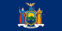 Flag 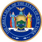 Seal | |
| Nickname(s): | |
| Motto(s): | |
| Anthem: "I Love New York" | |
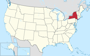 Map of the United States with New York highlighted | |
| Country | United States |
| Before statehood | Province of New York |
| Admitted to the Union | July 26, 1788 (11th) |
| Capital | Albany |
| Largest city | New York City |
| Largest metro | New York metropolitan area |
| Government | |
| • Governor | Andrew Cuomo (D) |
| • Lieutenant Governor | Kathy Hochul (D) |
| Legislature | State Legislature |
| • Upper house | State Senate |
| • Lower house | State Assembly |
| U.S. senators |
|
| U.S. House delegation |
|
| Area | |
| • Total | 54,555[2] sq mi (141,300 km2) |
| Area rank | 27th |
| Dimensions | |
| • Length | 330 mi (530 km) |
| • Width | 285 mi (455 km) |
| Elevation | 1,000 ft (300 m) |
| Highest elevation | 5,344 ft (1,629 m) |
| Lowest elevation | 0 ft (0 m) |
| Population (2019) | |
| • Total | 19,453,561[6] |
| • Rank | 4th |
| • Density | 416.42/sq mi (159/km2) |
| • Density rank | 7th |
| • Median household income | $64,894 (2,017)[7] |
| • Income rank | 15th |
| Demonym(s) | New Yorker |
| Language | |
| • Official language | None |
| • Spoken language | |
| Time zone | UTC−05:00 (Eastern) |
| • Summer (DST) | UTC−04:00 (EDT) |
| USPS abbreviation | NY |
| ISO 3166 code | US-NY |
| Trad. abbreviation | N.Y. |
| Latitude | 40° 30′ N to 45° 1′ N |
| Longitude | 71° 51′ W to 79° 46′ W |
| Website | www |
| New York state symbols | |
|---|---|
| Living insignia | |
| Bird | Eastern bluebird |
| Fish | Brook trout (fresh water), Striped bass (salt water) |
| Flower | Rose |
| Insect | Nine-spotted ladybug |
| Mammal | North American beaver |
| Reptile | Common snapping turtle |
| Tree | Sugar maple |
| Inanimate insignia | |
| Beverage | Milk |
| Food |
|
| Fossil | Eurypterus remipes |
| Gemstone | Garnet |
| Shell | Bay scallop |
| Other | Bush: Lilac bush |
| State route marker | |
 | |
| State quarter | |
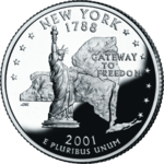 Released in 2001 | |
| Lists of United States state symbols | |
Two-thirds of the state's population lives in the New York metropolitan area (nearly 40% on Long Island).[10] The state and city were both named for the 17th-century Duke of York, the future King James II of England. With an estimated population of 8.34 million in 2019,[10] New York City is the most populous city in the United States and the premier gateway for legal immigration to the United States.[11][12][13] The New York metropolitan area is one of the most populous in the world.[14][15]
New York City is a global city,[16] home to the United Nations Headquarters,[17] and has been described as the cultural,[18][19] financial,[20][21] and media capital[22][23] of the world, as well as the world's most economically powerful city.[24][20][25] The next four most populous cities in the state are Buffalo, Rochester, Yonkers, and Syracuse, while the state capital is Albany.
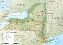
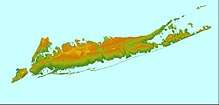
The 27th largest U.S. state in land area, New York has a diverse geography. The state is bordered by New Jersey and Pennsylvania to the south and Connecticut, Massachusetts, and Vermont to the east. The state has a maritime border with Rhode Island, east of Long Island, as well as an international border with the Canadian provinces of Quebec to the north and Ontario to the northwest. The southern part of the state is in the Atlantic coastal plain and includes Long Island and several smaller associated islands, as well as New York City and the lower Hudson River Valley. The large Upstate New York region comprises several ranges of the wider Appalachian Mountains, and the Adirondack Mountains in the Northeastern lobe of the state. The north–south Hudson River Valley and the east–west Mohawk River Valley bisect these more mountainous regions. Western New York is considered part of the Great Lakes region and borders Lake Ontario, Lake Erie, and Niagara Falls. The central part of the state is dominated by the Finger Lakes, a popular vacation and tourist destination.
New York had been inhabited by tribes of Algonquian and Iroquoian-speaking Native Americans for several hundred years by the time the earliest Europeans came to New York. French colonists and Jesuit missionaries arrived southward from Montreal for trade and proselytizing. In 1609, the region was visited by Henry Hudson sailing for the Dutch East India Company. The Dutch built Fort Nassau in 1614 at the confluence of the Hudson and Mohawk rivers, where the present-day capital of Albany later developed. The Dutch soon also settled New Amsterdam and parts of the Hudson Valley, establishing the multicultural colony of New Netherland, a center of trade and immigration. England seized the colony from the Dutch in 1664. During the American Revolutionary War (1775–1783), a group of colonists of the Province of New York attempted to take control of the British colony and eventually succeeded in establishing independence. In the 19th century, New York's development of the interior, beginning with the Erie Canal, gave it incomparable advantages over other regions of the east coast and built its political and cultural ascendancy.[26]
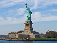
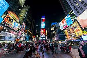
Many landmarks in New York are well known, including four of the world's ten most-visited tourist attractions in 2013: Times Square, Central Park, Niagara Falls, and Grand Central Terminal.[27] New York is home to the Statue of Liberty, a symbol of the United States and its ideals of freedom, democracy, and opportunity.[28] In the 21st century, New York has emerged as a global node of creativity and entrepreneurship,[29] social tolerance,[30] and environmental sustainability.[31][32] New York's higher education network comprises approximately 200 colleges and universities, including Columbia University, Cornell University, New York University, the United States Military Academy, the United States Merchant Marine Academy, University of Rochester, Rensselaer Polytechnic Institute, and Rockefeller University, which have been ranked among the top 100 in the nation and world. Additionally, Stony Brook University and Binghamton University are the state's top public universities, both receiving top 100 in the US rankings by US News at #78 and #91 respectively. [33][34][35][36]
History
Native American history
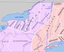
The tribes in what is now New York were predominantly Haudenosaunee and Algonquian. Long Island was divided roughly in half between the Wampanoag and Lenape. The Lenape also controlled most of the region surrounding New York Harbor. North of the Lenape was a third Algonquian nation, the Mohicans. Starting north of them, from east to west, were three Iroquoian nations: the Mohawk, the original Iroquois and the Petun. South of them, divided roughly along Appalachia, were the Susquehannock and the Erie.[37][38][39][40][41][42]
Many of the Wampanoag and Mohican peoples were caught up in King Philip's War, a joint effort of many New England tribes to push Europeans off their land. After the death of their leader, Chief Philip Metacomet, most of those peoples fled inland, splitting into the Abenaki and the Schaghticoke. Many of the Mohicans remained in the region until the 1800s,[43] however, a small group known as the Ouabano migrated southwest into West Virginia at an earlier time. They may have merged with the Shawnee.[44][45]
The Mohawk and Susquehannock were the most militaristic. Trying to corner trade with the Europeans, they targeted other tribes. The Mohawk were also known for refusing white settlement on their land and banishing any of their people who converted to Christianity. They posed a major threat to the Abenaki and Mohicans, while the Susquehannock briefly conquered the Lenape in the 1600s. The most devastating event of the century, however, was the Beaver Wars. From approximately 1640–1680, Iroquoian peoples waged campaigns which extended from modern-day Michigan to Virginia against Algonquian and Siouan tribes, as well as each other. The aim was to control more land for animal trapping, a career most natives had turned to in hopes of trading with whites first. This completely changed the ethnography of the region, and most large game was hunted out before whites ever fully explored the land. Still, afterward, the Iroquois Confederacy offered shelter to refugees of the Mascouten, Erie, Chonnonton, Tutelo, Saponi, and Tuscarora nations. In the 1700s, they would also merge with the Mohawk during the French-Indian War and take in the remaining Susquehannock of Pennsylvania after they were decimated in war.[46] Most of these other groups blended in until they ceased to exist. Then, after the Revolution, a large group of them split off and returned to Ohio, becoming known as the Mingo Seneca. The current six tribes of the Iroquois Confederacy are the Seneca, Cayuga, Onondaga, Oneida, Tuscarora and Mohawk. The Iroquois fought for both sides during the revolution; afterwards many pro-British Iroquois migrated to Canada. Today, the Iroquois still live in several reservations in upstate New York.[47][48][49][50]
Meanwhile, the Lenape formed a close relationship with William Penn. However, upon Penn's death, his sons managed to take over much of their lands and banish them to Ohio.[51] When the U.S. drafted the Indian Removal Act, the Lenape were further moved to Missouri, whereas their cousins, the Mohicans, were sent to Wisconsin.
Also, in 1778, the United States relocated the Nanticoke from the Delmarva Peninsula to the former Iroquois lands south of Lake Ontario, though they did not stay long. Mostly, they chose to migrate into Canada and merge with the Iroquois, although some moved west and merged with the Lenape.[52]
16th century
In 1524, Giovanni da Verrazzano, an Italian explorer in the service of the French crown, explored the Atlantic coast of North America between the Carolinas and Newfoundland, including New York Harbor and Narragansett Bay. On April 17, 1524, Verrazzano entered New York Bay, by way of the strait now called the Narrows into the northern bay which he named Santa Margherita, in honor of the King of France's sister. Verrazzano described it as "a vast coastline with a deep delta in which every kind of ship could pass" and he adds: "that it extends inland for a league and opens up to form a beautiful lake. This vast sheet of water swarmed with native boats". He landed on the tip of Manhattan and possibly on the furthest point of Long Island. Verrazzano's stay was interrupted by a storm which pushed him north towards Martha's Vineyard.[53]
In 1540, French traders from New France built a chateau on Castle Island, within present-day Albany; it was abandoned the following year due to flooding. In 1614, the Dutch, under the command of Hendrick Corstiaensen, rebuilt the French chateau, which they called Fort Nassau. Fort Nassau was the first Dutch settlement in North America, and was located along the Hudson River, also within present-day Albany. The small fort served as a trading post and warehouse. Located on the Hudson River flood plain, the rudimentary "fort" was washed away by flooding in 1617,[54] and abandoned for good after Fort Orange (New Netherland) was built nearby in 1623.[55]
17th century
Henry Hudson's 1609 voyage marked the beginning of European involvement with the area. Sailing for the Dutch East India Company and looking for a passage to Asia, he entered the Upper New York Bay on September 11 of that year.[56] Word of his findings encouraged Dutch merchants to explore the coast in search for profitable fur trading with local Native American tribes.
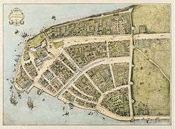
During the 17th century, Dutch trading posts established for the trade of pelts from the Lenape, Iroquois, and other tribes were founded in the colony of New Netherland. The first of these trading posts were Fort Nassau (1614, near present-day Albany); Fort Orange (1624, on the Hudson River just south of the current city of Albany and created to replace Fort Nassau), developing into settlement Beverwijck (1647), and into what became Albany; Fort Amsterdam (1625, to develop into the town New Amsterdam which is present-day New York City); and Esopus, (1653, now Kingston). The success of the patroonship of Rensselaerswyck (1630), which surrounded Albany and lasted until the mid-19th century, was also a key factor in the early success of the colony. The English captured the colony during the Second Anglo-Dutch War and governed it as the Province of New York. The city of New York was recaptured by the Dutch in 1673 during the Third Anglo-Dutch War (1672–1674) and renamed New Orange. It was returned to the English under the terms of the Treaty of Westminster a year later.[57]
18th century, the American Revolution, and statehood
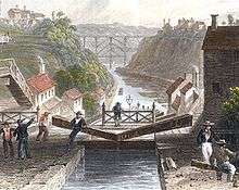
.jpg)
The Sons of Liberty were organized in New York City during the 1760s, largely in response to the oppressive Stamp Act passed by the British Parliament in 1765. The Stamp Act Congress met in the city on October 19 of that year, composed of representatives from across the Thirteen Colonies who set the stage for the Continental Congress to follow. The Stamp Act Congress resulted in the Declaration of Rights and Grievances, which was the first written expression by representatives of the Americans of many of the rights and complaints later expressed in the United States Declaration of Independence. This included the right to representative government. At the same time, given strong commercial, personal and sentimental links to Britain, many New York residents were Loyalists. The Capture of Fort Ticonderoga provided the cannon and gunpowder necessary to force a British withdrawal from the Siege of Boston in 1775.
New York was the only colony not to vote for independence, as the delegates were not authorized to do so. New York then endorsed the Declaration of Independence on July 9, 1776.[58] The New York State Constitution was framed by a convention which assembled at White Plains on July 10, 1776, and after repeated adjournments and changes of location, finished its work at Kingston on Sunday evening, April 20, 1777, when the new constitution drafted by John Jay was adopted with but one dissenting vote. It was not submitted to the people for ratification. On July 30, 1777, George Clinton was inaugurated as the first Governor of New York at Kingston.
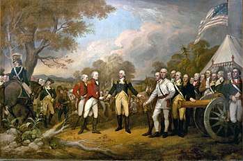
About a third of the battles of the American Revolutionary War took place in New York; the first major one (and largest of the entire war) was the Battle of Long Island, a.k.a. Battle of Brooklyn, in August 1776. After their victory, the British occupied New York City, making it their military and political base of operations in North America for the duration of the conflict, and consequently the focus of General George Washington's intelligence network. On the notorious British prison ships of Wallabout Bay, more American combatants died of intentional neglect than were killed in combat in every battle of the war combined. Both sides of combatants lost more soldiers to disease than to outright wounds. The first of two major British armies were captured by the Continental Army at the Battle of Saratoga in 1777, a success that influenced France to ally with the revolutionaries.The state constitution was enacted in 1777. New York became the 11th state to ratify the United States Constitution, on July 26, 1788.
In an attempt to retain their sovereignty and remain an independent nation positioned between the new United States and British North America, four of the Iroquois Nations fought on the side of the British; only the Oneida and their dependents, the Tuscarora, allied themselves with the Americans.[59] In retaliation for attacks on the frontier led by Joseph Brant and Loyalist Mohawk forces, the Sullivan Expedition of 1779 destroyed nearly 50 Iroquois villages, adjacent croplands and winter stores, forcing many refugees to British-held Niagara.[60]
As allies of the British, the Iroquois were forced out of New York, although they had not been part of treaty negotiations. They resettled in Canada after the war and were given land grants by the Crown. In the treaty settlement, the British ceded most Indian lands to the new United States. Because New York made treaty with the Iroquois without getting Congressional approval, some of the land purchases have been subject to land claim suits since the late 20th century by the federally recognized tribes. New York put up more than 5 million acres (20,000 km2) of former Iroquois territory for sale in the years after the Revolutionary War, leading to rapid development in upstate New York.[61] As per the Treaty of Paris, the last vestige of British authority in the former Thirteen Colonies—their troops in New York City—departed in 1783, which was long afterward celebrated as Evacuation Day.[62]
New York City was the national capital under the Articles of Confederation and Perpetual Union, the first national government. That organization was found to be insufficient, and prominent New Yorker Alexander Hamilton advocated a new government that would include an executive, national courts, and the power to tax. Hamilton led the Annapolis Convention (1786) that called for the Philadelphia Convention, which drafted the United States Constitution, in which he also took part. The new government was to be a strong federal national government to replace the relatively weaker confederation of individual states. Following heated debate, which included the publication of the now quintessential constitutional interpretation—The Federalist Papers—as a series of installments in New York City newspapers, New York was the 11th state to ratify the United States Constitution, on July 26, 1788.[63] New York remained the national capital under the new constitution until 1790,[64] and was the site of the inauguration of President George Washington,[65] the drafting of the United States Bill of Rights, and the first session of the United States Supreme Court. Hamilton's revival of the heavily indebted United States economy after the war and the creation of a national bank significantly contributed to New York City becoming the financial center of the new nation.
Both the Dutch and the British imported African slaves as laborers to the city and colony; New York had the second-highest population of slaves after Charleston, South Carolina. Slavery was extensive in New York City and some agricultural areas. The state passed a law for the gradual abolition of slavery soon after the Revolutionary War, but the last slave in New York was not freed until 1827.[66]
19th century
Transportation in western New York was by expensive wagons on muddy roads before canals opened up the rich farm lands to long-distance traffic. Governor DeWitt Clinton promoted the Erie Canal, which connected New York City to the Great Lakes by the Hudson River, the new canal, and the rivers and lakes. Work commenced in 1817, and the Erie Canal opened in 1825. Packet boats pulled by horses on tow paths traveled slowly over the canal carrying passengers and freight.[67] Farm products came in from the Midwest, and finished manufactured goods moved west. It was an engineering marvel which opened up vast areas of New York to commerce and settlement. It enabled Great Lakes port cities such as Buffalo and Rochester to grow and prosper. It also connected the burgeoning agricultural production of the Midwest and shipping on the Great Lakes, with the port of New York City. Improving transportation, it enabled additional population migration to territories west of New York. After 1850, railroads largely replaced the canal.[68]
New York City was a major ocean port and had extensive traffic importing cotton from the South and exporting manufacturing goods. Nearly half of the state's exports were related to cotton. Southern cotton factors, planters and bankers visited so often that they had favorite hotels.[69] At the same time, activism for abolitionism was strong upstate, where some communities provided stops on the Underground Railroad. Upstate, and New York City, gave strong support for the American Civil War, in terms of finances, volunteer soldiers, and supplies. The state provided more than 370,000 soldiers to the Union armies. Over 53,000 New Yorkers died in service, roughly one of every seven who served. However, Irish draft riots in 1862 were a significant embarrassment.[70][71]
Immigration
Since the early 19th century, New York City has been the largest port of entry for legal immigration into the United States. In the United States, the federal government did not assume direct jurisdiction for immigration until 1890. Prior to this time, the matter was delegated to the individual states, then via contract between the states and the federal government. Most immigrants to New York would disembark at the bustling docks along the Hudson and East Rivers, in the eventual Lower Manhattan. On May 4, 1847, the New York State Legislature created the Board of Commissioners of Immigration to regulate immigration.[72]
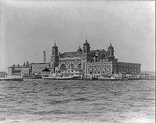
The first permanent immigration depot in New York was established in 1855 at Castle Garden, a converted War of 1812 era fort located within what is now Battery Park, at the tip of Lower Manhattan. The first immigrants to arrive at the new depot were aboard three ships that had just been released from quarantine. Castle Garden served as New York's immigrant depot until it closed on April 18, 1890, when the federal government assumed control over immigration. During that period, more than eight million immigrants passed through its doors (two of every three U.S. immigrants).[73]
When the federal government assumed control, it established the Bureau of Immigration, which chose the three-acre Ellis Island in Upper New York Harbor for an entry depot. Already federally controlled, the island had served as an ammunition depot. It was chosen due its relative isolation with proximity to New York City and the rail lines of Jersey City, New Jersey, via a short ferry ride. While the island was being developed and expanded via land reclamation, the federal government operated a temporary depot at the Barge Office at the Battery.[74]
Ellis Island opened on January 1, 1892, and operated as a central immigration center until the National Origins Act was passed in 1924, reducing immigration. After that date, the only immigrants to pass through were displaced persons or war refugees. The island ceased all immigration processing on November 12, 1954, when the last person detained on the island, Norwegian seaman Arne Peterssen, was released. He had overstayed his shore leave and left on the 10:15 a.m. Manhattan-bound ferry to return to his ship.
More than twelve million immigrants passed through Ellis Island between 1892 and 1954. More than a hundred million Americans across the United States can trace their ancestry to these immigrants.
Ellis Island was the subject of a contentious and long-running border and jurisdictional dispute between New York State and the State of New Jersey, as both claimed it. The issue was settled in 1998 by the U.S. Supreme Court which ruled that the original 3.3-acre (1.3 ha) island was New York State territory and that the balance of the 27.5 acres (11 ha) added after 1834 by landfill was in New Jersey.[75] The island was added to the National Park Service system in May 1965 by President Lyndon B. Johnson and is still owned by the Federal government as part of the Statue of Liberty National Monument. Ellis Island was opened to the public as a museum of immigration in 1990.[76]
September 11, 2001
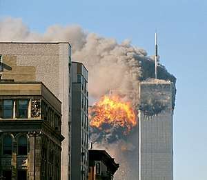
On September 11, 2001, two of four hijacked planes were flown into the Twin Towers of the original World Trade Center in Lower Manhattan, and the towers collapsed. 7 World Trade Center also collapsed due to damage from fires. The other buildings of the World Trade Center complex were damaged beyond repair and demolished soon thereafter. The collapse of the Twin Towers caused extensive damage and resulted in the deaths of 2,753 victims, including 147 aboard the two planes. Since September 11, most of Lower Manhattan has been restored. In the years since, many rescue workers and residents of the area have developed several life-threatening illnesses, and some have died.[77]
A memorial at the site, the National September 11 Memorial & Museum, was opened to the public on September 11, 2011. A permanent museum later opened at the site on March 21, 2014. Upon its completion in 2014, the new One World Trade Center became the tallest skyscraper in the Western Hemisphere, at 1,776 feet (541 m), meant to symbolize the year America gained its independence, 1776.[78] Other skyscrapers are under construction at the site.
Hurricane Sandy, 2012
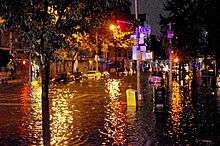
On October 29 and 30, 2012, Hurricane Sandy caused extensive destruction of the state's shorelines, ravaging portions of New York City, Long Island, and southern Westchester with record-high storm surge, with severe flooding and high winds causing power outages for hundreds of thousands of New Yorkers, and leading to gasoline shortages and disruption of mass transit systems. The storm and its profound effects have prompted the discussion of constructing seawalls and other coastal barriers around the shorelines of New York City and Long Island to minimize the risk from another such future event. This is considered highly probable due to global warming and rise in sea levels.[79][80]
Geography
New York covers 54,555 square miles (141,300 km2) and ranks as the 27th largest state by size.[2] The highest elevation in New York is Mount Marcy in the Adirondacks, at 5,344 feet (1,629 meters) above sea level; while the state's lowest point is at sea level, on the Atlantic Ocean.[83]
In contrast with New York City's urban landscape, the vast majority of the state's geographic area is dominated by meadows, forests, rivers, farms, mountains, and lakes. Most of the southern part of the state rests on the Allegheny Plateau, which extends from the southeastern United States to the Catskill Mountains; the section in New York State is known as the Southern Tier. The rugged Adirondack Mountains, with vast tracts of wilderness, lie west of the Lake Champlain Valley. The Great Appalachian Valley dominates eastern New York and contains the Lake Champlain Valley as its northern half and the Hudson Valley as its southern half within the state. The Tug Hill region arises as a cuesta east of Lake Ontario.[84]
Upstate and downstate are often used informally to distinguish New York City or its greater metropolitan area from the rest of New York State. The placement of a boundary between the two is a matter of great contention.[85] Unofficial and loosely defined regions of Upstate New York include the Southern Tier, which often includes the counties along the border with Pennsylvania,[86] and the North Country, which can mean anything from the strip along the Canada–U.S. border to everything north of the Mohawk River.[87]
New York contains a part of the Marcellus shale, which extends into Ohio and Pennsylvania.[88]
Water
Borders
Of New York State's total area, 13.6% consists of water.[89] Much of New York's boundaries are in water, as is true for New York City: four of its five boroughs are situated on three islands at the mouth of the Hudson River: Manhattan Island; Staten Island; and Long Island, which contains Brooklyn and Queens at its western end. The state's borders include a water boundary in (clockwise from the west) two Great Lakes (Lake Erie and Lake Ontario, which are connected by the Niagara River); the provinces of Ontario and Quebec in Canada, with New York and Ontario sharing the Thousand Islands archipelago within the Saint Lawrence River, while most of its border with Quebec is on land; it shares Lake Champlain with the New England state of Vermont; the New England state of Massachusetts has mostly a land border; New York extends into Long Island Sound and the Atlantic Ocean, sharing a water border with Rhode Island, while Connecticut has land and sea borders. Except for areas near the New York Harbor and the Upper Delaware River, New York has a mostly land border with two Mid-Atlantic states, New Jersey and Pennsylvania. New York is the only state that includes within its borders parts of the Great Lakes and the Atlantic Ocean.
Drainage
The Hudson River begins near Lake Tear of the Clouds and flows south through the eastern part of the state, without draining Lakes George or Champlain. Lake George empties at its north end into Lake Champlain, whose northern end extends into Canada, where it drains into the Richelieu River and then ultimately the Saint Lawrence River. The western section of the state is drained by the Allegheny River and rivers of the Susquehanna and Delaware River systems. Niagara Falls is shared between New York and Ontario as it flows on the Niagara River from Lake Erie to Lake Ontario. The Delaware River Basin Compact, signed in 1961 by New York, New Jersey, Pennsylvania, Delaware, and the federal government, regulates the utilization of water of the Delaware system.[90]
Climate

In general, New York has a humid continental climate, though under the Köppen climate classification, New York City has a humid subtropical climate.[91] Weather in New York is heavily influenced by two continental air masses: a warm, humid one from the southwest and a cold, dry one from the northwest.
Downstate New York, comprising New York City, Long Island, and lower portions of the Hudson Valley, has rather warm summers with some periods of high humidity and cold, damp winters which are relatively mild compared to temperatures in Upstate New York due to downstate region's lower elevation, proximity to the Atlantic Ocean, and relatively lower latitude. Upstate New York experiences warm summers, marred by only occasional, brief intervals of sultry conditions, with long and cold winters. Western New York, particularly the Tug Hill region, receives heavy lake-effect snows, especially during the earlier portions of winter, before the surface of Lake Ontario itself is covered by ice. The summer climate is cool in the Adirondacks, Catskills, and at higher elevations of the Southern Tier.
Summer daytime temperatures usually range from the upper 70s to mid-80s °F (25 to 29 °C), over much of the state. In the majority of winter seasons, a temperature of −13 °F (−25 °C) or lower can be expected in the northern highlands (Northern Plateau) and 5 °F (−15 °C) or colder in the southwestern and east-central highlands of the Southern Tier.
New York ranks 46th among the 50 states in the amount of greenhouse gases generated per person. This relative efficient energy usage is primarily due to the dense, compact settlement in the New York City metropolitan area, and the state population's high rate of mass transit use in this area and between major cities.[92]
Flora and fauna
Flora
Some species that can be found in this state are american ginseng, starry stonewort, waterthyme, water chestnut, eastern poison ivy, poison sumac, giant hogweed, cow parsnip and common nettle.[93]
Fauna
There are more than 20 mammal species, more than 20 bird species, some species of amphibians, and several reptile species.
Species of mammals that are part of New York are white-footed mouse, North America least shrew, little brown bat, muskrat, eastern gray squirrel, eastern cottontail, stoat, groundhog, striped skunk, fisher, North American river otter, raccoon, bobcat, coyote, red fox, white-tailed deer, moose and American black bear.[94]
Some species of birds in New Yok are the ring-necked pheasant, northern bobwhite, ruffed grouse, wild turkey, blue jay, eastern bluebird, American robin and lack-capped chickadee. Birds of prey that are present in the state are great horned owls, bald eagles, red-tailed hawks, American kestrels and northern harriers. Waterfowls like mallards, wood ducks, canvasbacks, American black ducks, Canada gooses and blue-winged teals can be found in the region. Maritime or shore birds of New York are great blue herons, killdeers, Northern cardinals, American herring gulls and common terns.[95]
Reptiles species that can be seen in land areas of New York are queen snake, massasauga, hellbender, diamondback terrapin, spotted turle, malaclemys terrapin and Blanding's turtle. Species of turtles that can be found in the sea are green sea turtle, loggerhead sea turtle, leatherback sea turlte and Kemp's Ridley Sea Turtle.[96]
New York Harbor and the Hudson River constitute an estuary, making New York state home to a rich array of shellfish—such as oysters and clams—as well as fish, microorganisms, and sea-birds.
Regions
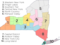
Due to its long history, New York has several overlapping and often conflicting definitions of regions within the state. The regions are also not fully definable due to colloquial use of regional labels. The New York State Department of Economic Development provides two distinct definitions of these regions. It divides the state into ten economic regions,[97] which approximately correspond to terminology used by residents:
- Western New York
- Finger Lakes
- Southern Tier
- Central New York
- North Country
- Mohawk Valley
- Capital District
- Hudson Valley
- New York City
- Long Island
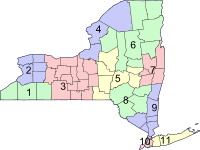
The department also groups the counties into eleven regions for tourism purposes:[98]
- Chautauqua–Allegheny
- Niagara Frontier
- Finger Lakes
- Thousand Islands
- Central-Leatherstocking Region
- Adirondack Mountains
- Capital District
- Catskill Mountains
- Hudson Valley
- New York City
- Long Island
State parks

New York has many state parks and two major forest preserves. Niagara Falls State Park, established in 1885, is the oldest state park in the United States[99] and the first to be created via eminent domain.[100] In 1892, Adirondack Park, roughly the size of the state of Vermont and the largest state park in the United States,[101] was established and given state constitutional protection to remain "forever wild" in 1894. The park is larger than Yellowstone, Everglades, Glacier, and Grand Canyon national parks combined.[101] It is larger than the Yellowstone, Yosemite, Grand Canyon, Glacier, and Olympic National Parks combined.[102] The Catskill Park was protected in legislation passed in 1885,[103] which declared that its land was to be conserved and never put up for sale or lease. Consisting of 700,000 acres (2,800 km2) of land,[103] the park is a habitat for deer, minks, and fishers. There are some 400 black bears living in the region.[104] The state operates numerous campgrounds, and there are over 300 miles (480 km) of multi-use trails in the Park.
The 1797 Montauk Lighthouse, commissioned under President George Washington, is a major tourist attraction in Montauk State Park at the easternmost tip of Long Island. Hither Hills State Park, also on the South Fork of Long Island, offers camping and is a popular destination with surfcasting sport fishermen.
National parks, monuments, and historic landmarks
The State of New York is well represented in the National Park System with 22 national parks, which received 16,349,381 visitors in 2011. In addition, there are four National Heritage Areas, 27 National Natural Landmarks, 262 National Historic Landmarks, and 5,379 listings on the National Register of Historic Places.
- Statue of Liberty National Monument includes Ellis Island and the Statue of Liberty. The statue, designed by Frédéric Bartholdi and formally named Liberty Enlightening the World, was a gift from France to the United States to mark the Centennial of the American Declaration of Independence; it was dedicated in New York Harbor on October 28, 1886. It has since become an icon of the United States and the concepts of democracy and freedom.
- African Burial Ground National Monument in Lower Manhattan is the only National Monument dedicated to Americans of African ancestry. It preserves a site containing the remains of more than 400 Africans buried during the late 17th and 18th centuries in a portion of what was the largest colonial-era cemetery for people of African descent, both free and enslaved, with an estimated tens of thousands of remains interred. The site's excavation and study were called "the most important historic urban archeological project in the United States".[106]
- Fire Island National Seashore is a United States National Seashore that protects a 26-mile (42 km) section of Fire Island, an approximately 30-mile (48 km) long barrier island separated from the mainland of Long Island by the Great South Bay. The island is part of Suffolk County.
- Gateway National Recreation Area is more than 26,000 acres (10,522 ha) of water, salt marsh, wetlands, islands, and shoreline at the entrance to New York Harbor, the majority of which lies within New York. Including areas on Long Island and in New Jersey, it covers more area than that of two Manhattan Islands.
- General Grant National Memorial is the final resting place of President Ulysses S. Grant and is the largest mausoleum in North America.
- Hamilton Grange National Memorial preserves the home of Alexander Hamilton, Caribbean immigrant and orphan who rose to be a United States founding father and associate of George Washington.
- Home of Franklin D. Roosevelt National Historic Site, established in 1945, preserves the Springwood estate in Hyde Park, New York. Springwood was the birthplace, lifelong home, and burial place of the 32nd President of the United States, Franklin D. Roosevelt.
- Niagara Falls National Heritage Area was designated by Congress in 2008; it stretches from the western boundary of Wheatfield, New York to the mouth of the Niagara River on Lake Ontario, including the communities of Niagara Falls, Youngstown, and Lewiston. It includes Niagara Falls State Park and Colonial Niagara Historic District. It is managed in collaboration with the state.
- Saratoga National Historical Park preserves the site of the Battles of Saratoga, the first significant American military victory of the American Revolutionary War. In 1777, American forces defeated a major British Army, which led France to recognize the independence of the United States, and enter the war as a decisive military ally of the struggling Americans.
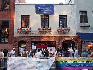
- Stonewall National Monument, in the Greenwich Village neighborhood of Lower Manhattan, is the first U.S. National Monument dedicated to LGBTQ rights, designated on June 24, 2016. The monument comprises the Stonewall Inn, commonly recognized to be the cradle of the gay liberation movement as the site of the 1969 Stonewall Riots; the adjacent Christopher Park; and surrounding streets and sidewalks.[107][108][109]
- Manhattan's Theodore Roosevelt Birthplace National Historic Site is also the childhood home of President Theodore Roosevelt, the only president born in New York City until Donald Trump.
Administrative divisions
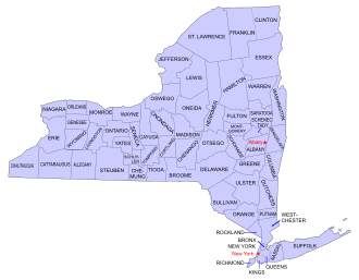
New York is divided into 62 counties. Aside from the five counties of New York City, each of these counties is subdivided into towns and cities, incorporated under state law. Towns can contain incorporated villages or unincorporated hamlets. New York City is divided into five boroughs, each coterminous with a county.
Downstate New York (New York City, Long Island, and the southern portion of the Hudson Valley) can be considered to form the central core of the Northeast megalopolis, an urbanized region stretching from New Hampshire to Virginia.
The major cities of the state developed along the key transportation and trade routes of the early 19th century, including the Erie Canal and railroads paralleling it. Today, the New York Thruway acts as a modern counterpart to commercial water routes.[110]
Cities and towns
There are 62 cities in New York. The largest city in the state and the most populous city in the United States is New York City, which comprises five counties (each coextensive with a borough): Bronx, New York County (Manhattan), Queens, Kings County (Brooklyn), and Richmond County (Staten Island). New York City is home to more than two-fifths of the state's population. Albany, the state capital, is the sixth-largest city in New York State. The smallest city is Sherrill, New York, in Oneida County. Hempstead is the most populous town in the state; if it were a city, it would be the second largest in New York State, with more than 700,000 residents.
New York contains 13 metropolitan areas, as defined by the U.S. Census Bureau.[111] Major metro areas include New York City, Buffalo, Rochester, the Capital District (Albany, Schenectady, and Troy), Poughkeepsie, Syracuse, Utica, and Binghamton.
Demographics
Population
| Historical population | |||
|---|---|---|---|
| Census | Pop. | %± | |
| 1790 | 340,120 | — | |
| 1800 | 589,051 | 73.2% | |
| 1810 | 959,049 | 62.8% | |
| 1820 | 1,372,812 | 43.1% | |
| 1830 | 1,918,608 | 39.8% | |
| 1840 | 2,428,921 | 26.6% | |
| 1850 | 3,097,394 | 27.5% | |
| 1860 | 3,880,735 | 25.3% | |
| 1870 | 4,382,759 | 12.9% | |
| 1880 | 5,082,871 | 16.0% | |
| 1890 | 6,003,174 | 18.1% | |
| 1900 | 7,268,894 | 21.1% | |
| 1910 | 9,113,614 | 25.4% | |
| 1920 | 10,385,227 | 14.0% | |
| 1930 | 12,588,066 | 21.2% | |
| 1940 | 13,479,142 | 7.1% | |
| 1950 | 14,830,192 | 10.0% | |
| 1960 | 16,782,304 | 13.2% | |
| 1970 | 18,236,967 | 8.7% | |
| 1980 | 17,558,072 | −3.7% | |
| 1990 | 17,990,455 | 2.5% | |
| 2000 | 18,976,457 | 5.5% | |
| 2010 | 19,378,102 | 2.1% | |
| Est. 2019 | 19,453,561 | 0.4% | |
| Sources: 1910–2010 1790–1900[113] 2019 Estimate[6] | |||
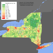 New York population distribution map |
The nation's most populous state until the 1960s, New York is now the fourth most-populous state. The distribution of change in population growth is uneven in New York State; the New York City metropolitan area is growing, along with Saratoga County, while cities such as Buffalo, Rochester, and Syracuse and several others having been losing population for decades.[114] New York City gained more residents between April 2010 and July 2018 (223,615) than any other U.S. city.[115] Conversely, outside of the Ithaca area, population growth in much of Western New York is nearly stagnant.[114] According to immigration statistics, the state is a leading recipient of migrants from around the globe. Between 2000 and 2005, immigration failed to surpass out-migration to other parts of the United States, a trend that has been reversing since 2006. New York State lost two House seats in the 2011 congressional reapportionment, secondary to relatively slow growth when compared to the rest of the United States. In 2000 and 2005, more people moved from New York to Florida than from any one state to another, contributing to New York's becoming the fourth most populous state in 2015 behind Florida, Texas, and California.[116] However, New York State has the second-largest international immigrant population in the country among the American states, at 4.2 million as of 2008; most reside in and around New York City, due to its size, high profile, vibrant economy, and cosmopolitan culture. New York has a pro-sanctuary city law.[117]
The United States Census Bureau estimates that the population of New York was 19,453,561 on July 1, 2019, a 0.39% increase since the 2010 United States Census.[6] Despite the open land in the state, New York's population is very urban, with 92% of residents living in an urban area,[118] predominantly in the New York City metropolitan area.
Two-thirds of New York State's population resides in New York City metropolitan area. New York City is the most populous city in the United States,[119] with an estimated record high population of 8,622,698 in 2017,[10] incorporating more immigration into the city than emigration since the 2010 United States Census.[120] At least twice as many people live in New York City as in the second-most populous U.S. city (Los Angeles),[121] and within a smaller area. Long Island alone accounted for a Census-estimated 7,838,722 residents in 2015, representing 39.6% of New York State's population.[10][122][123][124][125]
6.5% of New York's population were under five years of age, 24.7% under 18, and 12.9% were 65 or older.
Race and ethnicity
Hispanic or Latino of any race were 17.6% of the population in 2010: 2.4% were of Mexican, 5.5% Puerto Rican, 0.4% Cuban, and 9.4% other Hispanic or Latino origin. According to the 2010–2015 American Community Survey, the largest ancestry groups were Italian (13.0%), Irish (12.1%), German (10.3%), American (5.4%), and English (5.2%).[126][127]
The state's most populous racial group, non-Hispanic white, has declined as a proportion of the state population from 94.6% in 1940 to 58.3% in 2010.[128][129] As of 2011, 55.6% of New York's population younger than age 1 were minorities.[130] New York's robustly increasing Jewish population, the largest outside of Israel,[131] was the highest among states both by percentage and by absolute number in 2012.[132] It is driven by the high reproductive rate of Orthodox Jewish families,[133] particularly in Brooklyn and communities of the Hudson Valley.
New York is home to the largest African American population and the second largest Asian-American population (after California) in the United States. New York's uniracial Black population increased by 2.0% between 2000 and 2010, to 3,073,800.[134] The Black population is in a state of flux, as New York is the largest recipient of immigrants from Africa,[135] while established African Americans are migrating out of New York to the southern United States.[136] The New York City neighborhood of Harlem has historically been a major cultural capital for African-Americans of sub-Saharan descent, and Bedford-Stuyvesant in Brooklyn has the largest such population in the United States. Meanwhile, New York's uniracial Asian population increased by a notable 36% from 2000 to 2010, to 1,420,244.[134] Queens, in New York City, is home to the state's largest Asian-American population and is the most ethnically diverse county in the United States; it is the most ethnically diverse urban area in the world.[137][138]
New York's growing uniracial Hispanic-or-Latino population numbered 3,416,922 in 2010,[139] a 19% increase from the 2,867,583 enumerated in 2000.[140] Queens is home to the largest Andean (Colombian, Ecuadorian, Peruvian, and Bolivian) populations in the United States. In addition, New York has the largest Puerto Rican, Dominican, and Jamaican American populations in the continental United States. The Chinese population constitutes the fastest-growing nationality in New York State, which is the top destination for new Chinese immigrants, and large-scale Chinese immigration continues into the state.[135][141][142][143][144] Multiple satellites of the original Manhattan Chinatown, in Brooklyn, and around Flushing, Queens, are thriving as traditionally urban enclaves, while also expanding rapidly eastward into suburban Nassau County,[145] on Long Island .[146] Long Island, including Queens and Nassau County, is also home to several Little Indias (लघु भारत) and a large Koreatown (롱 아일랜드 코리아타운), with large and growing attendant populations of Indian Americans and Korean Americans, respectively. Brooklyn has been a destination for West Indian immigrants of African descent, as well as Asian Indian immigrants. The annual New York City India Day Parade, held on or approximately every August 15 since 1981, is the world's largest Indian Independence Day parade outside of India.[147]
In the 2000 Census, New York had the largest Italian American population, composing the largest self-identified ancestral group in Staten Island and Long Island, followed by Irish Americans. Albany and the Mohawk Valley also have large communities of ethnic Italians and Irish Americans, reflecting 19th and early 20th-century immigration. According to the American Community Survey, New York had the largest Greek American population too, which counts 148,637 people (0.7% of the state).[127] In Buffalo and western New York, German Americans comprise the largest ancestry. In the North Country of New York, French Canadians represent the leading ethnicity, given the area's proximity to Quebec. Americans of English ancestry are present throughout all of upstate New York, reflecting early colonial and later immigrants.
| |||||||||||||||||||||||||||||||||||||||||||||||||||||
.svg.png)
Languages
| Language | Population |
|---|---|
| Spanish | 14.44% |
| Chinese (incl. Cantonese and Mandarin) | 2.61% |
| Russian | 1.20% |
| Italian | 1.18% |
| French Creole | 0.79% |
| French | 0.75% |
| Yiddish | 0.67% |
| Korean | 0.63% |
| Polish | 0.53% |
| Bengali | 0.43% |
In 2010, the most common American English dialects spoken in New York, besides General American English, were the New York City area dialect (including New York Latino English and North Jersey English), the Western New England accent around Albany, and Inland Northern American English in Buffalo and western New York State. As many as 800 languages are spoken in New York City,[152][153][154] making it the most linguistically diverse city in the world.[155]
As of 2010, 70.72% (12,788,233) of New York residents aged five and older reported speaking only English at home, while 14.44% (2,611,903) spoke Spanish, 2.61% (472,955) Chinese (which includes Cantonese and Mandarin), 1.20% (216,468) Russian, 1.18% (213,785) Italian, 0.79% (142,169) French Creole, 0.75% (135,789) French, 0.67% (121,917) Yiddish, 0.63% (114,574) Korean, and Polish was spoken by 0.53% (95,413) of the population over the age of five. In total, 29.28% (5,295,016) of New York's population aged five and older reported speaking a language other than English.[151]
Religion
In 2010, the Association of Religion Data Archives (ARDA) reported that the largest denominations were the Catholic Church with 6,286,916; Orthodox Judaism with 588,500; Islam with 392,953; and the United Methodist Church with 328,315 adherents.[156]
| Affiliation | % of New York population | |
|---|---|---|
| Christian | 60 | |
| Catholic | 31 | |
| Protestant | 26 | |
| Evangelical Protestant | 10 | |
| Mainline Protestant | 11 | |
| Black church | 5 | |
| Other Christian | 3 | |
| Unaffiliated | 27 | |
| Nothing in particular | 17 | |
| Agnostic | 5 | |
| Atheist | 5 | |
| Jewish | 7 | |
| Muslim | 2 | |
| Buddhist | 1 | |
| Hindu | 1 | |
| Other faiths | 0.5 | |
| Don't know/refused answer | 1 | |
Before the 1800s, Protestant sects dominated the religious life of New York, although religion did not play as large a role in the public life of New Netherland as it did in New England, with its Puritan population.[158]
Religious revivals and the formation of new religious movements of the Second Great Awakening took place in the burned-over district of western and central regions of New York in the early 19th century.
LGBT
Roughly 3.8 percent of the state's adult population self-identifies as lesbian, gay, bisexual, or transgender. This constitutes a total LGBT adult population of 570,388 individuals.[159] In 2010, the number of same-sex couple households stood at roughly 48,932.[160] New York was the fifth state to license same-sex marriages, after New Hampshire. Michael Bloomberg, the Mayor of New York City, stated that "same-sex marriages in New York City have generated an estimated $259 million in economic impact and $16 million in City revenues" in the first year after the enactment of the Marriage Equality Act".[161] Same-sex marriages in New York were legalized on June 24, 2011, and were authorized to take place beginning 30 days thereafter.[162] New York City is also home to the largest transgender population in the United States, estimated at 25,000 in 2016.[163] The annual New York City Pride March (or gay pride parade) traverses southward down Fifth Avenue in Manhattan, ending at Greenwich Village, and rivals the Sao Paulo Gay Pride Parade as the largest pride parade in the world, attracting tens of thousands of participants and millions of sidewalk spectators each June.[164]
The Stonewall riots were a series of spontaneous, violent demonstrations by members of the gay community against a police raid that took place in the early morning hours of June 28, 1969, at the Stonewall Inn in the Greenwich Village neighborhood within Lower Manhattan. They are widely considered to constitute the single most important event leading to the gay liberation movement[165][166][167][168] and the modern fight for LGBT rights.[169][170] In June 2017, plans were announced for the first official monument to LGBT individuals commissioned by the State of New York, in contrast to the Stonewall National Monument, which was commissioned by the U.S. federal government. The State monument is planned to be built in Hudson River Park in Manhattan, near the waterfront Hudson River piers which have served as historically significant symbols of New York's central role as a meeting place and a safe haven for LGBT communities.[171]
Also as of 2017, plans were advancing by the State of New York to host the largest international LGBT pride celebration in 2019, known as Stonewall 50 – WorldPride NYC 2019, to commemorate the 50th anniversary of the Stonewall Riots.[172] In New York City, the Stonewall 50–WorldPride NYC 2019 events produced by Heritage of Pride will be enhanced through a partnership made with the I LOVE NY program's LGBT division and shall include a welcome center during the weeks surrounding the Stonewall 50 / WorldPride events that is open to all. Additional commemorative arts, cultural, and educational programing to mark the 50th anniversary of the rebellion at the Stonewall Inn will be taking place throughout the city and the world; it is believed that 2019 will be the largest international LGBT pride celebration held in history.[173]
Economy
New York's gross state product in 2018 was $1.7 trillion.[174] If New York State were an independent nation, it would rank as the 11th largest economy in the world.[175] However, in 2013, the multi-state, New York City-centered metropolitan statistical area produced a gross metropolitan product (GMP) of nearly $1.4 trillion,[176] while in 2012, the corresponding combined statistical area[177] generated a GMP of over $1.7 trillion, both ranking first nationally by a wide margin and behind the GDP of only nine nations.[178]
Wall Street
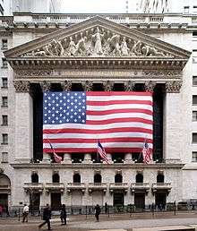
Anchored by Wall Street in the Financial District of Lower Manhattan, New York City has been called both the most economically powerful city and the leading financial center of the world.[20][24][180][181][182] Lower Manhattan is the third-largest central business district in the United States and is home to the New York Stock Exchange, on Wall Street, and the NASDAQ, at 165 Broadway, representing the world's largest and second largest stock exchanges, respectively, as measured both by overall average daily trading volume and by total market capitalization of their listed companies in 2013.[179][183] Investment banking fees on Wall Street totaled approximately $40 billion in 2012,[184] while in 2013, senior New York City bank officers who manage risk and compliance functions earned as much as $324,000 annually.[185] In fiscal year 2013–14, Wall Street's securities industry generated 19% of New York State's tax revenue.[186] New York City remains the largest global center for trading in public equity and debt capital markets, driven in part by the size and financial development of the U.S. economy.[187]:31–32[188] New York also leads in hedge fund management; private equity; and the monetary volume of mergers and acquisitions. Several investment banks and investment managers headquartered in Manhattan are important participants in other global financial centers.[187]:34–35 New York is also the principal commercial banking center of the United States.[189]
Many of the world's largest media conglomerates are also based in the city. Manhattan contained approximately 520 million square feet (48.1 million m2) of office space in 2013,[190] making it the largest office market in the United States,[191] while Midtown Manhattan is the largest central business district in the nation.[192]
Silicon Alley
Silicon Alley, centered in New York City, has evolved into a metonym for the sphere encompassing the New York City metropolitan region's high technology and entrepreneurship ecosystem; in 2015, Silicon Alley generated over $7.3 billion in venture capital investment.[29] High tech industries including digital media, biotechnology, software development, game design, and other fields in information technology are growing, bolstered by New York City's position at the terminus of several transatlantic fiber optic trunk lines,[193] its intellectual capital, as well as its growing outdoor wireless connectivity.[194] In December 2014, New York State announced a $50 million venture-capital fund to encourage enterprises working in biotechnology and advanced materials; according to Governor Andrew Cuomo, the seed money would facilitate entrepreneurs in bringing their research into the marketplace.[195] On December 19, 2011, then Mayor Michael R. Bloomberg announced his choice of Cornell University and Technion-Israel Institute of Technology to build a two billion dollar graduate school of applied sciences on Roosevelt Island in Manhattan, with the goal of transforming New York City into the world's premier technology capital.[196][197]
Tech Valley
Albany,[198] Saratoga County,[199][200] Rensselaer County, and the Hudson Valley, collectively recognized as eastern New York's Tech Valley, have experienced significant growth in the computer hardware side of the high-technology industry, with great strides in the nanotechnology sector, digital electronics design, and water- and electricity-dependent integrated microchip circuit manufacturing,[199] involving companies including IBM and its Thomas J. Watson Research Center,[201] and the three foreign-owned firms, GlobalFoundries, Samsung, and Taiwan Semiconductor, among others.[198][202] The area's high technology ecosystem is supported by technologically focused academic institutions including Rensselaer Polytechnic Institute and the SUNY Polytechnic Institute.[198] In 2015, Tech Valley, straddling both sides of the Adirondack Northway and the New York Thruway, generated over $163 million in venture capital investment.[29] The Rochester area is important in the field of photographic processing and imaging as well as incubating an increasingly diverse high technology sphere encompassing STEM fields, similarly in part the result of private startup enterprises collaborating with major academic institutions, including the University of Rochester and Cornell University.[203] Westchester County has developed a burgeoning biotechnology sector in the 21st century, with over a billion dollars in planned private investment as of 2016,[204][205]
Media and entertainment
Creative industries, which are concerned with generating and distributing knowledge and information, such as new media, digital media, film and television production, advertising, fashion, design, and architecture, account for a growing share of employment, with New York City possessing a strong competitive advantage in these industries.[206] As of 2014, New York State was offering tax incentives of up to $420 million annually for filmmaking within the state, the most generous such tax rebate among the U.S. states. New York has also attracted higher-wage visual-effects employment by further augmenting its tax credit to a maximum of 35% for performing post-film production work in Upstate New York.[207] The filmed entertainment industry has been growing in New York, contributing nearly $9 billion to the New York City economy alone as of 2015.[208]
Tourism
I Love New York (stylized I ❤ NY) is a slogan, a logo and a song that are the basis of an advertising campaign and has been used since 1977 to promote tourism in the state of New York,[209] including New York City.[210] The trademarked logo is owned by New York State Empire State Development.[211] The Broadway League reported that Broadway shows sold approximately $1.27 billion worth of tickets in the 2013–2014 season, an 11.4% increase from $1.139 billion in the 2012–2013 season. Attendance in 2013–2014 stood at 12.21 million, representing a 5.5% increase from the 2012–2013 season's 11.57 million.[212]
"I Love New York" is the state song of New York.[213]
Exports
New York exports a wide variety of goods such as prepared foods, computers and electronics, cut diamonds, and other commodities. In 2007, the state exported a total of $71.1 billion worth of goods, with the five largest foreign export markets being Canada ($15 billion), the United Kingdom ($6 billion), Switzerland ($5.9 billion), Israel ($4.9 billion), and Hong Kong ($3.4 billion). New York's largest imports are oil, gold, aluminum, natural gas, electricity, rough diamonds, and lumber. The state also has a large manufacturing sector that includes printing and the production of garments, mainly in New York City; and furs, railroad equipment, automobile parts, and bus line vehicles, concentrated in Upstate regions.
New York is the nation's third-largest grape producing state, and second-largest wine producer by volume, behind California. The southern Finger Lakes hillsides, the Hudson Valley, the North Fork of Long Island, and the southern shore of Lake Erie are the primary grape- and wine-growing regions in New York, with many vineyards. In 2012, New York had 320 wineries and 37,000 grape bearing acres, generating full-time employment for nearly 25,000 and annual wages over $1.1 billion, and yielding $4.8 billion in direct economic impact from New York grapes, grape juice, and wine and grape products.[214]
New York is a major agricultural producer overall, ranking among the top five states for agricultural products including maple syrup, apples, cherries, cabbage, dairy products, onions, and potatoes. The state is the largest producer of cabbage in the U.S. The state has about a quarter of its land in farms and produced $3.4 billion in agricultural products in 2001. The south shore of Lake Ontario provides the right mix of soils and microclimate for many apple, cherry, plum, pear and peach orchards. Apples are also grown in the Hudson Valley and near Lake Champlain. A moderately sized saltwater commercial fishery is located along the Atlantic side of Long Island. The principal catches by value are clams, lobsters, squid, and flounder.
Energy
In 2017, New York State consumed 156,370-gigawatthours (GWh) of electrical energy. Downstate regions (Hudson Valley, New York City, and Long Island) consumed 66% of that amount. Upstate regions produced 50% of that amount. The peak load in 2017 was 29,699 MW. The resource capability in 2017 was 42,839 MW.[215][216] The NYISO's market monitor described the average all-in wholesale electric price as a range (a single value was not provided) from $25 per MWh to $53 per MWh for 2017.[217]
Education
The University of the State of New York accredits and sets standards for primary, middle-level, and secondary education in the state, while the New York State Education Department oversees public schools and controls their standardized tests. The New York City Department of Education manages the New York City Public Schools system. In 1894, reflecting general racial discrimination then, the state passed a law that allowed communities to set up separate schools for children of African-American descent. In 1900, the state passed another law requiring integrated schools.[218]
At the level of post-secondary education, the statewide public university system is the State University of New York (SUNY). The SUNY system consists of 64 community colleges, technical colleges, undergraduate colleges, and doctoral-granting institutions, including several universities. New York's largest public university is the State University of New York at Buffalo, which was founded by U.S. President Millard Fillmore.[219][220] The four SUNY University Centers, offering a wide array of academic programs, are the University at Albany, Binghamton University, Stony Brook University, and the University at Buffalo. New York City has its own City University of New York (CUNY) system, which is funded by the city.
Columbia University, Cornell University, New York University, and the University of Rochester are among the most prominent of the larger higher education institutions in New York, all of them leading, world-renowned private universities and members of the Association of American Universities, the pre-eminent group of research universities in the United States. Other notable large private universities include Syracuse University and Fordham University. Smaller notable private institutions of higher education include Rockefeller University, Mercy College, New York Institute of Technology, Rensselaer Polytechnic Institute, Yeshiva University, and Hofstra University. There are also a multitude of postgraduate-level schools in New York State, including medical, law, and engineering schools.
West Point, the service academy of the U.S. Army, is located just south of Newburgh, on the west bank of the Hudson River. The federal Merchant Marine Academy is at Kings Point on Long Island.
A number of selective private liberal arts institutions are located in New York. Among them are Bard College, Barnard College, Colgate University, Hamilton College, Hobart and William Smith Colleges, Marist College, Sarah Lawrence College, Skidmore College, Union College, and Vassar College. Two of these schools, Barnard and Vassar, are members of the elite Seven Sisters, originally all women's colleges with ties to the Ivy League. Barnard is affiliated with Columbia University, its Manhattan neighbor, and Vassar became coeducational in 1969 after declining an offer to merge with Yale University.
New York is also home to what are widely regarded as the best performing arts schools in the world. The Juilliard School, located in the Upper West Side of Manhattan, is one of the world's leading music and dance schools.[221][222][223] The Eastman School of Music, a professional school within the University of Rochester, was ranked first among U.S. music schools by U.S. News & World Report for five consecutive years.[224]
During the 2013 fiscal year, New York spent more on public education per pupil than any other state, according to U.S. Census Bureau statistics.[225]
Transportation

New York has one of the most extensive and one of the oldest transportation infrastructures in the country. Engineering challenges posed by the complex terrain of the state and the unique infrastructural issues of New York City brought on by urban crowding have had to be overcome perennially. Population expansion of the state has followed the path of the early waterways, first the Hudson River and Mohawk River, then the Erie Canal. In the 19th century, railroads were constructed along the river valleys, followed by the New York State Thruway in the 20th century.
The New York State Department of Transportation (NYSDOT) is the department of the government of New York[226] responsible for the development and operation of highways, railroads, mass transit systems, ports, waterways, and aviation facilities within New York State. The NYSDOT is headquartered at 50 Wolf Road in Colonie, Albany County. The Port Authority of New York and New Jersey (PANYNJ) is a joint venture between the States of New York and New Jersey and authorized by the US Congress, established in 1921 through an interstate compact, that oversees much of the regional transportation infrastructure, including bridges, tunnels, airports, and seaports, within the geographical jurisdiction of the Port of New York and New Jersey. This 1,500 sq mi (3,900 km2) port district is generally encompassed within a 25 mi (40 km) radius of the Statue of Liberty National Monument.[227] The Port Authority is headquartered at 4 World Trade Center in Lower Manhattan.
In addition to the well known New York City Subway system—which is confined within New York City—four suburban commuter railroad systems enter and leave the city: the Long Island Rail Road, Metro-North Railroad, Port Authority Trans-Hudson, and five of New Jersey Transit's rail lines. The New York City Department of Transportation (NYCDOT) is the agency of the government of New York City[228] responsible for the management of much of New York City's own transportation infrastructure. Other cities and towns in New York have urban and regional public transportation. In Buffalo, the Niagara Frontier Transportation Authority runs the Buffalo Metro Rail light-rail system; in Rochester, the Rochester Subway operated from 1927 until 1956, but fell into disuse as state and federal investment went to highways.

The New York State Department of Motor Vehicles (NYSDMV or DMV) is the governmental agency responsible for registering and inspecting automobiles and other motor vehicles, as well as licensing drivers in the State of New York. As of 2008, the NYSDMV has 11,284,546 drivers licenses on file[229] and 10,697,644 vehicle registrations in force.[230] All gasoline-powered vehicles registered in New York State are required to have an emissions inspection every 12 months, in order to ensure that environmental quality controls are working to prevent air pollution. Diesel-powered vehicles with a gross weight rating over 8,500 lb that are registered in most Downstate New York counties must get an annual emissions inspection. All vehicles registered in New York State must get an annual safety inspection.
Portions of the transportation system are intermodal, allowing travelers to switch easily from one mode of transportation to another. One of the most notable examples is AirTrain JFK which allows rail passengers to travel directly to terminals at John F. Kennedy International Airport as well as to the underground New York City Subway system.
Government

The Government of New York embodies the governmental structure of the State of New York as established by the New York State Constitution. It is composed of three branches: executive, legislative, and judicial.
The Governor is the State's chief executive and is assisted by the Lieutenant Governor. Both are elected on the same ticket. Additional elected officers include the Attorney General, and the Comptroller. The Secretary of State, formerly an elected officer, is currently appointed by the Governor.
The New York State Legislature is bicameral and consists of the New York State Senate and the New York State Assembly. The Assembly consists of 150 members, while the Senate varies in its number of members, currently having 63. The Legislature is empowered to make laws, subject to the Governor's power to veto a bill. However, the veto may be overridden by the Legislature if there is a two-thirds majority in favor of overriding in each House. The permanent laws of a general nature are codified in the Consolidated Laws of New York.
The highest court of appeal in the Unified Court System is the Court of Appeals whereas the primary felony trial court is the County Court (or the Supreme Court in New York City). The Supreme Court also acts as the intermediate appellate court for many cases, and the local courts handle a variety of other matters including small claims, traffic ticket cases, and local zoning matters, and are the starting point for all criminal cases. The New York City courts make up the largest local court system.
The state is divided into counties, cities, towns, and villages, all of which are municipal corporations with respect to their own governments, as well as various corporate entities that serve single purposes that are also local governments, such as school districts, fire districts, and New York state public-benefit corporations, frequently known as authorities or development corporations. Each municipal corporation is granted varying home rule powers as provided by the New York Constitution. The state also has 10 Indian reservations. There have been several movements regarding secession from the state of New York. Proposals have included a state of Long Island, consisting of everything on the island outside New York City; a state called Niagara, the western counties of New York state; the northern counties of New York state called Upstate New York; making the city of New York a state; a proposal for a new Peconic County on eastern Long Island; and for the borough of Staten Island to secede from New York City.
Capital punishment
Capital punishment was reintroduced in 1995 under the Pataki administration, but the statute was declared unconstitutional in 2004, when the New York Court of Appeals ruled in People v. LaValle that it violated the state constitution. The remaining death sentence was commuted by the court to life imprisonment in 2007, in People v. John Taylor, and the death row was disestablished in 2008, under executive order from Governor Paterson. No execution has taken place in New York since 1963. Legislative efforts to amend the statute have failed, and death sentences are no longer sought at the state level, though certain crimes that fall under the jurisdiction of the federal government are subject to the federal death penalty.[231][232][233]
Federal representation
New York is represented by Chuck Schumer and Kirsten Gillibrand in the United States Senate. There are twenty-seven congressional districts , the nation's third equal highest number of congressional districts, equal with Florida and behind California's 53 and Texas's 36.[234] As of 2019, twenty-one districts are represented by members of the Democratic Party, while six are represented by Republicans. Representation was reduced from 29 in 2013 due to the state's slower overall population growth relative to the overall national population growth.[235] New York has 29 electoral votes in national presidential elections, a drop from its peak of 47 votes from 1933 to 1953.
The state has a strong imbalance of payments with the federal government. According to the Office of the New York State Comptroller, New York State received 91 cents in services for every $1 it sent in taxes to the U.S. federal government in the 2013 fiscal year; New York ranked in 46th place in the federal balance of payments to the state on a per capita basis.[236]
Politics

As of April 2016, Democrats represented a plurality of voters in New York State, constituting more than twice as many registered voters as any other political party affiliation or lack thereof.[237] Since the second half of the 20th century, New York has generally supported candidates belonging to the Democratic Party in national elections. Democratic presidential candidate Barack Obama won New York State by over 25 percentage points in both 2012 and 2008. New York City, as well as the state's other major urban locales, including Albany, Buffalo, Rochester, Yonkers, and Syracuse, are significant Democratic strongholds, with liberal politics. Rural portions of upstate New York, however, are generally more conservative than the cities and tend to favor Republicans. Heavily populated suburban areas downstate, such as Westchester County and Long Island, have swung between the major parties since the 1980s, but more often than not support Democrats.
New York City is the most important source of political fundraising in the United States for both major parties. Four of the top five zip codes in the nation for political contributions are in Manhattan. The top zip code, 10021 on the Upper East Side, generated the most money for the 2000 presidential campaigns of both George W. Bush and Al Gore.[238]
The state of New York has the distinction of being the home state for both major-party nominees in three presidential elections. The 1904 presidential election saw former New York Governor and incumbent President Theodore Roosevelt face Alton B. Parker, chief judge of the New York Court of Appeals. The 1944 presidential election had Franklin D. Roosevelt, following in his cousin Theodore's footsteps as former New York Governor and incumbent president running for re-election against then-current New York Governor Thomas E. Dewey. In the 2016 presidential election, former United States Senator from New York Hillary Clinton, a resident of Chappaqua, was the Democratic Party nominee. The Republican Party nominee was businessman Donald Trump, a resident of Manhattan and a native of Queens.[239]
New York City is an important center for international diplomacy.[240] The United Nations Headquarters has been situated on the East Side of Midtown Manhattan since 1952.
Sports
New York State is geographically home to one National Football League team, the Buffalo Bills, based in the Buffalo suburb of Orchard Park. Although the New York Giants and New York Jets represent the New York metropolitan area and were previously located in New York City, they play in MetLife Stadium, located in East Rutherford, New Jersey. New York also has two Major League Baseball teams, the New York Yankees (based in the Bronx) and the New York Mets (based in Queens). Minor league baseball teams also play in the State of New York, including the Long Island Ducks, the Brooklyn Cyclones, and the Staten Island Yankees downstate, and the Rochester Red Wings, the Binghamton Rumble Ponies, the Syracuse Mets, the Auburn Doubledays, the Batavia Muckdogs, the Hudson Valley Renegades and the Buffalo Bisons upstate. New York is home to three National Hockey League franchises: the New York Rangers in Manhattan, the New York Islanders in Brooklyn, and the Buffalo Sabres in Buffalo. New York has two National Basketball Association teams, the New York Knicks in Manhattan, and the Brooklyn Nets in Brooklyn. New York is the home of a Major League Soccer franchise, New York City FC, currently playing in the Bronx. Although the New York Red Bulls represent the New York metropolitan area, they play in Red Bull Arena in Harrison, New Jersey.
New York hosted the 1932 and 1980 Winter Olympics at Lake Placid. The 1980 Games are known for the USA–USSR ice hockey match dubbed the "Miracle on Ice", in which a group of American college students and amateurs defeated the heavily favored Soviet national ice hockey team 4–3 and went on to win the gold medal against Finland. Along with St. Moritz, Switzerland and Innsbruck, Austria, Lake Placid is one of the three cities to have hosted the Winter Olympic Games twice. New York City bid for the 2012 Summer Olympics but lost to London.
Several U.S. national sports halls of fame are or have been situated in New York. The National Baseball Hall of Fame and Museum is located in Cooperstown, Otsego County. The National Museum of Racing and Hall of Fame in Saratoga Springs, Saratoga County, honors achievements in the sport of thoroughbred horse racing. The physical facility of the National Soccer Hall of Fame in Oneonta, also in Otsego County, closed in 2010, although the organization itself has continued inductions. The annual United States Open Tennis Championships is one of the world's four Grand Slam tennis tournaments and is held at the National Tennis Center in Flushing Meadows–Corona Park in the New York City borough of Queens.[241]
| New York State major league professional sports teams | ||
|---|---|---|
| Club | Sport | League |
| Buffalo Bills | Football | National Football League |
| Brooklyn Nets | Basketball | National Basketball Association |
| New York Knicks | Basketball | National Basketball Association |
| New York City FC | Soccer | Major League Soccer |
| Buffalo Sabres | Ice hockey | National Hockey League |
| New York Islanders | Ice hockey | National Hockey League |
| New York Rangers | Ice hockey | National Hockey League |
| New York Mets | Baseball | Major League Baseball |
| New York Yankees | Baseball | Major League Baseball |
| New York Giants | Football | National Football League |
| New York Jets | Football | National Football League |
| New York Red Bulls | Soccer | Major League Soccer |
See also
- Index of New York (state)-related articles
- Outline of New York
References
- "New York State Motto". New York State Library. January 29, 2001. Archived from the original on May 24, 2009. Retrieved November 16, 2007.
- "Land and Water Area of States (2000)". Infoplease.com. Retrieved April 11, 2008.
- "Marcy". NGS data sheet. U.S. National Geodetic Survey. Retrieved October 20, 2011.
- "Elevations and Distances in the United States". United States Geological Survey. 2001. Archived from the original on February 1, 2009. Retrieved October 24, 2011.
- Elevation adjusted to North American Vertical Datum of 1988.
- "Population and Housing Unit Estimates". United States Census Bureau. January 29, 2020. Retrieved January 29, 2020.
- "Median Annual Household Income—2017". Henry J. Kaiser Family Foundation. 2019. Retrieved April 8, 2019.
- "Language spoken at home by ability to speak English for the population 5 years and over—2014 American Community Survey 1-Year Estimates". Archived from the original on February 13, 2020. Retrieved January 24, 2016.
- "Population Of New York 2019 – US Population 2019". Retrieved April 5, 2020.
- "2018 ACS DEMOGRAPHIC AND HOUSING ESTIMATES". United States Census Bureau. Retrieved March 10, 2020.
- "Supplemental Table 2. Persons Obtaining Lawful Permanent Resident Status by Leading Core Based Statistical Areas (CBSAs) of Residence and Region and Country of Birth: Fiscal Year 2014". U.S. Department of Homeland Security. 2014. Archived from the original on March 22, 2017. Retrieved June 1, 2016.
- "Yearbook of Immigration Statistics: 2013 Supplemental Table 2". U.S. Department of Homeland Security. Retrieved May 29, 2015.
- "Yearbook of Immigration Statistics: 2012 Supplemental Table 2". U.S. Department of Homeland Security. Retrieved May 29, 2015.
- "World's Largest Urban Areas [Ranked by Urban Area Population]". Rhett Butler. 2003–2006. Archived from the original on October 9, 2009. Retrieved August 2, 2014.
- "Largest Cities of the World—(by metro population)". Woolwine-Moen Group d/b/a Graphic Maps. Retrieved August 2, 2014.
- "Global power city index 2009" (PDF). The Mori Memorial Foundation. 2009. Retrieved August 2, 2014.
- "Office of the Mayor Commission for the United Nations, Consular Corps and Protocol". The City of New York. 2012. Archived from the original on July 1, 2014. Retrieved August 2, 2014.
- "Introduction to Chapter 14: New York City (NYC) Culture". The Weissman Center for International Business Baruch College/CUNY 2011. Archived from the original on May 5, 2013. Retrieved August 2, 2014.
- "New York, Culture Capital of the World, 1940–1965 / edited by Leonard Wallock; essays by Dore Ashton ... [et al.]". NATIONAL LIBRARY OF AUSTRALIA. Retrieved August 2, 2014.
- "Top 8 Cities by GDP: China vs. The U.S." Business Insider, Inc. July 31, 2011. Retrieved October 28, 2015.
For instance, Shanghai, the largest Chinese city with the highest economic production, and a fast-growing global financial hub, is far from matching or surpassing New York, the largest city in the U.S. and the economic and financial super center of the world.
"PAL sets introductory fares to New York". Philippine Airlines. Retrieved March 25, 2015. - Huw Jones (January 27, 2020). "New York surges ahead of Brexit-shadowed London in finance: survey". Reuters. Retrieved January 27, 2020.
New York remains the world's top financial center, pushing London further into second place as Brexit uncertainty undermines the UK capital and Asian centers catch up, a survey from consultants Duff & Phelps said on Monday.
- Felix Richter (March 11, 2015). "New York Is The World's Media Capital". Statista. Retrieved May 29, 2017.
- Dawn Ennis (May 24, 2017). "ABC will broadcast New York's pride parade live for the first time". LGBTQ Nation. Retrieved May 29, 2017.
- Richard Florida (March 3, 2015). "Sorry, London: New York Is the World's Most Economically Powerful City". The Atlantic Monthly Group. Retrieved March 25, 2015.
Our new ranking puts the Big Apple firmly on top.
- Richard Florida (May 8, 2012). "What Is the World's Most Economically Powerful City?". The Atlantic Monthly Group. Retrieved March 25, 2015.
- Roberts, Sam (June 26, 2017). "200 Years Ago, Erie Canal Got Its Start as Just a 'Ditch'". The New York Times. Retrieved July 25, 2017.
- Ann Shields (November 10, 2014). "The World's 50 Most Visited Tourist Attractions—No. 3: Times Square, New York City—Annual Visitors: 50,000,000". Travel+Lesiure. Retrieved July 17, 2015.
No. 3 Times Square, New York City—Annual Visitors: 50,000,000 ... No. 4 (tie) Central Park, New York City—Annual Visitors: 40,000,000 ... No. 9 Niagara Falls, New York and Ontario—Annual Visitors: 22,000,000 ... No. 10 Grand Central Terminal, New York City—Annual Visitors: 21,600,000
- "Statue of Liberty". World Heritage. UNESCO. Retrieved July 17, 2015.
- "Venture Investment—Regional Aggregate Data". National Venture Capital Association and PricewaterhouseCoopers. Archived from the original on April 8, 2016. Retrieved April 22, 2016.
- Matt Flegenheimer (March 23, 2016). "Ted Cruz Deplores 'Liberal, Left-Wing Values' While Lobbying for New York Votes". The New York Times. Retrieved April 22, 2016.
- "The Latest: China Hopes US Joins Climate Deal Quickly". The New York Times. Associated Press. April 22, 2016. Retrieved April 22, 2016.
- Lisa Foderaro (September 21, 2014). "Taking a Call for Climate Change to the Streets". The New York Times. Retrieved April 22, 2016.
- https://www.usnews.com/best-colleges/rankings/national-universities
- "Academic Ranking of World Universities 2015". ShanghaiRanking Consultancy. Retrieved August 27, 2015.
- "CWUR 2015—World University Rankings". Center for World University Rankings. Retrieved August 27, 2015.
- https://www.usnews.com/best-colleges/rankings/national-universities
- "Iroquois Confederacy—History, Relations with non-native americans, Key issues". www.everyculture.com. Retrieved March 3, 2018.
- "Susquehannock Indians". www.departments.bucknell.edu. Retrieved March 3, 2018.
- "Erie Tribe—Access Genealogy". July 9, 2011. Retrieved March 3, 2018.
- English, J. "'PETUN' AND THE PETUNS". www.wyandot.org. Retrieved March 3, 2018.
- "Mahican Tribe—Access Genealogy". July 9, 2011. Retrieved March 3, 2018.
- Barron, Donna. "The Long Island Indians & Their New England Ancestors". 2006
- "King Philip's War—Native American History". History.com. Retrieved March 3, 2018.
- John Heckewelder (Loskiel): Conoys, Ganawese, etc. explains Charles A. Hanna (Vol II, 1911:96, Ganeiens-gaa, Margry, i., 529; ii., 142–43,) using La Salle's letter of August 22, 1681 Fort Saint Louis (Illinois) mentioning "Ohio tribes" for extrapolation.
- Hanna 1911:158
- Editor: Alvin M. Josephy, Jr., by The editors of American Heritage Magazine (1961). "The American Heritage Book of Indians" pages 188–219. American Heritage Publishing Co., Inc
- "Historical Timeline" (PDF). Oneida Nation. Retrieved December 19, 2019.
- "Seneca Nation". Retrieved December 19, 2019.
- "Beaver Wars ***". www.warpaths2peacepipes.com. Retrieved March 3, 2018.
- "Early Indian Migration in Ohio". genealogytrails.com. Retrieved March 3, 2018.
- "Official Site of the Delaware Tribe of Indians » The Walking Purchase". delawaretribe.org. Retrieved March 3, 2018.
- Pritzker 441
- "Centro Studi Storici Verrazzano—Official web site". April 15, 2009. Archived from the original on April 15, 2009. Retrieved March 3, 2018.
- "Castle Island".
- Reynolds, Cuyler (1906). Albany Chronicles: A History of the City Arranged Chronologically. J.B. Lyon Company. p. 18.
fort nassau albany.
- Nevius, Michelle and James, "New York's many 9/11 anniversaries: the Staten Island Peace Conference", Inside the Apple: A Streetwise History of New York City, September 8, 2008. Retrieved September 24, 2012.
- Scheltema, Gajus and Westerhuijs, Heleen (eds.), Exploring Historic Dutch New York. Museum of the City of New York/Dover Publications, New York (2011). ISBN 978-0-486-48637-6
- "Declaration of Independence". history.com. Archived from the original on April 9, 2008. Retrieved April 10, 2008.
- Alan Taylor (2006). The Divided Ground: Indians, Settlers, and the Northern Borderland of the American Revolution. Knopf. ISBN 978-0-679-45471-7.
- "Sullivan/Clinton Interactive Map Set". Retrieved August 30, 2010.
- Chen, David W. "Battle Over Iroquois Land Claims Escalates", The New York Times. May 16, 2000. Retrieved April 11, 2008.
- "Happy Evacuation Day". New York City Department of Parks and Recreation. Retrieved April 12, 2008.
- "New York's Ratification". The U.S. Constitution Online. Retrieved April 10, 2008.
- LeMay, Michael C. (December 10, 2012). Transforming America: Perspectives on U.S. Immigration [3 volumes]: Perspectives on U.S. Immigration. ABC-CLIO. ISBN 9780313396441.
- "George Washington's First Inaugrual Address: Primary Documents of American History (Virtual Programs & Services, Library of Congress)". www.loc.gov. Washington, George. Retrieved July 30, 2018.CS1 maint: others (link)
- "New York City Would Really Rather Not Talk About Its Slavery-Loving Past". Newsweek. April 15, 2015. Retrieved July 30, 2018.
- "The Erie Canal: A Brief History". New York State Canals. Archived from the original on January 24, 2010. Retrieved April 10, 2008.
- Peter L. Bernstein, Wedding of the waters: The Erie Canal and the making of a great nation (2005).
- Robert Greenhalgh Albion, The rise of New York port (1815–1860) (1939).
- Ernest A. McKay, The Civil War and New York City (1990).
- Frederick Phisterer, New York in the War of the Rebellion, 1861 To 1865 (1890), p. 88.
- "Castle Garden as An Immigrant Depot:1855–1890" (PDF). National Park Service. Archived from the original (PDF) on November 10, 2013. Retrieved September 9, 2013.
- "Castle Clinton". National Park Service. August 22, 2013. Retrieved September 9, 2013.
- Vincent J. Cannato: American Passage: The History of Ellis Island. p.50: Harper Collins (2009) ISBN 0060742739
- Linda Greenhouse (May 27, 1998). "The Ellis Island Verdict: The Ruling". The New York Times. Retrieved September 5, 2013.
- "Statue Of Liberty National Monument". Nps.gov. Retrieved September 9, 2013.
- Edelman, Susan (January 6, 2008). "Charting post-9/11 deaths". Retrieved January 22, 2012.
- Katia Hetter (November 12, 2013). "It's official: One World Trade Center to be tallest U.S. skyscraper". CNN. Retrieved November 12, 2013.
- Jeff Stone & Maria Gallucci (October 29, 2014). "Hurricane Sandy Anniversary 2014: Fortifying New York—How Well Armored Are We For The Next Superstorm?". International Business Times. Retrieved July 23, 2015.
- Robert S. Eshelman (November 15, 2012). "ADAPTATION: Political support for a sea wall in New York Harbor begins to form". E&E Publishing, LLC. Retrieved July 23, 2015.
- "Coronavirus in New York: Latest Updates". New York. March 28, 2020.
- "How New York became the epicenter of America's coronavirus crisis". Vox. March 27, 2020.
- "Elevations and Distances in the United States". U.S. Geological Survey. April 29, 2005. Archived from the original on February 1, 2009. Retrieved November 6, 2006.
- "Tug Hill Region". New York State Tug Hill Commission. Retrieved April 1, 2017.
- Eisenstadt, Peter, ed. (2005). The Encyclopedia of New York State. Syracuse University Press. p. 1619. ISBN 978-0-8156-0808-0.
- Eisenstadt, Peter, ed. (2005). The Encyclopedia of New York State. Syracuse University Press. p. 1437. ISBN 978-0-8156-0808-0.
- Eisenstadt, Peter, ed. (2005). The Encyclopedia of New York State. Syracuse University Press. ISBN 978-0-8156-0808-0.
- Kaplan, Thomas (December 17, 2014). "Citing Health Risks, Cuomo Bans Fracking in New York State". The New York Times.
- "Area of each state that is water". water.usgs.gov. Retrieved September 23, 2017.
- "Delaware River Basin Commission" (PDF). The State of New Jersey. Retrieved April 3, 2017.
- "Climate of New York". New York State Climate Office—Cornell University. Archived from the original on April 12, 2008. Retrieved April 10, 2008.
- The New York Post (June 3, 2007). "A Breath of Fresh New York Air". Archived from the original on June 6, 2007. Retrieved June 6, 2007.
- "Plants—NYS Dept. of Environmental Conservation". www.dec.ny.gov. Retrieved December 13, 2019.
- "Mammals of NYS—Conservationist Centerfold" (PDF). Retrieved December 13, 2019.
- "Birds of NYS—Conservationist Centerfold" (PDF). Retrieved December 13, 2019.
- "Amphibians & Reptiles—NYS Dept. of Environmental Conservation". www.dec.ny.gov. Retrieved December 13, 2019.
- "Age/sex/race in New York State: Based on Census 2010" (PDF). Retrieved May 15, 2012.
- "Map of eleven regions". Visitnewyorkstate.net. Retrieved October 2, 2010.
- Edmondson, Brad (2001). "Publication #72—Environmental Affairs in New York State: A Historical Overview" (PDF). New York State Archives. pp. 7–9. Retrieved April 1, 2017.
- "Niagara National Heritage Area Study Report". National Park Service. 2005. p. 26. Retrieved April 1, 2017.
- Largest Park Area in the Contiguous U.S. Remains Open to Visitors, Thursday, October 3, 2013. Regional Office of Sustainable Tourism / Lake Placid CVB. Retrieved July 26, 2014.
- About the Adirondack Park, Adirondack Park Agency. Retrieved July 1, 2009.
- "Catskill Park History". catskillpark.org. Archived from the original on May 2, 2006. Retrieved April 11, 2008.
- "The Catskill Region". catskillmtn.org. Retrieved September 15, 2014.
- "Statue of Liberty". World Heritage. UNESCO. Retrieved November 24, 2013.
- African Burial Ground, General Services Administration, accessed February 10, 2012
- Rosenberg, Eli (June 24, 2016). "Stonewall Inn Named National Monument, a First for the Gay Rights Movement". The New York Times. Retrieved April 8, 2019.
- "Stonewall National Monument". National Park Service, U.S. Department of the Interior. Retrieved April 8, 2019.
- Hayasaki, Erika (May 18, 2007). "For gays, a generation gap grows". Los Angeles Times. Retrieved April 8, 2019.
- "New York State Thruway". thruway.ny.gov. New York State Thruway Authority. Archived from the original on August 22, 2014. Retrieved September 15, 2014.
- "County and Metro Area Population Estimates". U.S. Census Bureau. Retrieved October 19, 2019.
- "U.S. Census Bureau QuickFacts: New York". New York—2018 Populations.
- "New York: 2000 (Population and Housing Unit Counts)" (PDF). 2000 United States Census. United States Census Bureau. 2000. Retrieved September 18, 2010. (page 1 of the document, page 31 of the file)
- "Community Facts—Find popular facts (population, income, etc.) and frequently requested data about your community". United States Census Bureau. Retrieved July 4, 2017.
- "Annual Estimates of the Resident Population for Incorporated Places of 50,000 or More, Ranked by July 1, 2018, Population: April 1, 2010. to July 1, 2018—United States—Places of 50,000+ Population—2018 Population Estimates". United States Census Bureau. Retrieved January 29, 2020.
- "Domestic Migration Flows for States from the 2005 ACS". Archived from the original (Microsoft Word) on October 25, 2007. Retrieved October 19, 2007.
- Shoichet, Catherine E. (May 9, 2019). "Florida is about to ban sanctuary cities. At least 11 other states have, too". CNN.
- Timothy S. Parker (September 10, 2010). "New York Fact Sheet: NY agriculture income population food education employment farms top commodities exports counties financial indicators poverty organic farming farm income America USDA". Ers.usda.gov. Retrieved October 2, 2010.
- Blake Ellis (March 25, 2011). "America's 5 biggest cities". CNN. Retrieved November 12, 2013.
- Roberts, Sam (March 14, 2013). "Fewer People Are Abandoning the Bronx, Census Data Show". The New York Times.
- "State & County QuickFacts Los Angeles (city), California". U.S. Census Bureau. Archived from the original on August 2, 2012. Retrieved July 9, 2015.
- "Kings County, New York QuickFacts". U.S. Census Bureau. Archived from the original on February 17, 2016. Retrieved March 24, 2016.
- "Queens County, New York QuickFacts". U.S. Census Bureau. Archived from the original on August 8, 2014. Retrieved March 24, 2016.
- "Nassau County, New York QuickFacts". U.S. Census Bureau. Archived from the original on June 7, 2011. Retrieved March 24, 2016.
- "Suffolk County, New York QuickFacts". U.S. Census Bureau. Archived from the original on July 20, 2011. Retrieved March 24, 2016.
- "2015 American Community Survey". U.S. Census Bureau. Archived from the original on February 13, 2020. Retrieved August 23, 2017.
- "2011-2015 American Community Survey Selected Population Tables". Retrieved August 10, 2018.
- "New York QuickFacts". U.S. Census Bureau. January 17, 2012. Archived from the original on May 16, 2015. Retrieved April 18, 2012.
- "Historical Census Statistics on Population Totals By Race, 1790 to 1990, and By Hispanic Origin, 1970 to 1990, For The United States, Regions, Divisions, and States". Archived from the original on July 25, 2008.
- "Americans under age 1 now mostly minorities, but not in Ohio: Statistical Snapshot". The Plain Dealer. June 3, 2012.
- Thomas Kaplan & Jason Horowitz (August 13, 2014). "Cuomo, Visiting Israel, Joins Growing U.S. List". The New York Times. Retrieved September 28, 2014.
- "Jewish Population in the United States, by State". American-Israeli Cooperative Enterprise. Retrieved November 11, 2013.
- David Brooks (March 7, 2013). "The Orthodox Surge". The New York Times. Retrieved November 11, 2013.
- "State & County QuickFacts—New York QuickLinks". United States Census Bureau. Archived from the original on September 5, 2015. Retrieved September 13, 2015.
- "Yearbook of Immigration Statistics: 2013 Supplemental Table 1". U.S. Department of Homeland Security. Retrieved May 29, 2015.
- Dan Bilefsky (June 21, 2011). "For New Life, Blacks in City Head to South". The New York Times. Retrieved September 13, 2015.
- Christine Kim; Demand Media. "Queens, New York, Sightseeing". USA Today. Retrieved July 19, 2014.
- Andrew Weber (April 30, 2013). "Queens". NewYork.com. Archived from the original on May 13, 2015. Retrieved July 19, 2014.
- "Profile of General Population and Housing Characteristics: 2010 Demographic Profile Data". U.S. Census Bureau. Archived from the original on February 12, 2020. Retrieved October 3, 2015.
- "Profile of General Demographic Characteristics: Census 2000 Summary File 1 (SF 1) 100-Percent Data". U.S. Census Bureau. Archived from the original on February 13, 2020. Retrieved October 3, 2015.
- "Yearbook of Immigration Statistics: 2012 Supplemental Table 1". U.S. Department of Homeland Security. Retrieved May 29, 2015.
- "Yearbook of Immigration Statistics: 2011 Supplemental Table 1". U.S. Department of Homeland Security. Retrieved November 10, 2013.
- "Yearbook of Immigration Statistics: 2010 Supplemental Table 1". U.S. Department of Homeland Security. Retrieved November 10, 2013.
- Marzulli, John (May 9, 2011). "Malaysian man smuggled illegal Chinese immigrants into Brooklyn using Queen Mary 2: authorities". The New York Daily News. Archived from the original on May 5, 2015. Retrieved November 10, 2013.
- "State & County QuickFacts Nassau County, New York QuickLinks". United States Census Bureau. Archived from the original on October 7, 2014. Retrieved November 14, 2013.
- Heng Shao (April 10, 2014). "Join The Great Gatsby: Chinese Real Estate Buyers Fan Out To Long Island's North Shore". Forbes. Retrieved August 2, 2014.
- Karina Cuevas (August 16, 2015). "Thousands celebrate at India Day Parade along Madison Avenue". Metro International. Retrieved August 16, 2015.
- "Population of New York: Census 2010 and 2000 Interactive Map, Demographics, Statistics, Quick Facts".
- "2010 Demographic Profile Data". U.S. Census Bureau. Archived from the original on February 12, 2020.
- "2017 American Community Survey". U.S. Census Bureau. 2017. Archived from the original on February 13, 2020. Retrieved March 3, 2019.
- "New York". Modern Language Association. Archived from the original on August 15, 2013. Retrieved August 6, 2013.
- "Endangered Language Alliance". 2012. Retrieved November 11, 2013.
- "Linguistics—Say what?". The Economist. September 10, 2011. Retrieved November 11, 2013.
- N. R. Kleinfield (January 15, 2016). "New Yorkers, Self-Assured and Opinionated, Defend Their Values". The New York Times. Retrieved January 15, 2016 – via MSN.
- Roberts, Sam (April 28, 2010). "Listening to (and Saving) the World's Languages". The New York Times. Retrieved November 11, 2013.
- "State Membership Report". The Association of Religion Data Archives. Retrieved November 27, 2013.
- Pew Research Center, "Religious Landscape Study: New York"
- "Religions". Retrieved November 25, 2018.
- "LGBT Percentage Highest in D.C., Lowest in North Dakota". State of the States. Gallup Politics. February 15, 2013.
- Williams Inst. Census Snapshot http://williamsinstitute.law.ucla.edu/category/research/census-lbgt-demographics-studies/%5B%5D
- "NYC Same-Sex Marriages Generate $259 Million in Economic Impact". New York City Mayor Bloomberg, retrieved November 26, 2013
- Nicholas Confessore & Michael Barbaro (June 24, 2011). "New York Allows Same-Sex Marriage, Becoming Largest State to Pass Law". The New York Times. Retrieved November 11, 2013.
- Jennifer Fermino (March 7, 2016). "De Blasio: NYC toilets won't discriminate by gender identity". New York Daily News. Retrieved March 26, 2016.
- "Revelers Take To The Streets For 48th Annual NYC Pride March". CBS New York. June 25, 2017. Retrieved June 29, 2017.
A sea of rainbows took over the Big Apple for the biggest pride parade in the world Sunday.
- Goicichea, Julia (August 16, 2017). "Why New York City Is a Major Destination for LGBT Travelers". The Culture Trip. Retrieved April 8, 2019.
- "Brief History of the Gay and Lesbian Rights Movement in the U.S." University of Kentucky. Retrieved September 2, 2017.
- Nell Frizzell (June 28, 2013). "Feature: How the Stonewall riots started the LGBT rights movement". Pink News UK. Retrieved August 31, 2017.
- "Stonewall riots". Encyclopædia Britannica. Retrieved August 31, 2017.
- U.S. National Park Service (October 17, 2016). "Civil Rights at Stonewall National Monument". Department of the Interior. Retrieved August 31, 2017.
- "Obama inaugural speech references Stonewall gay-rights riots". Archived from the original on May 30, 2013. Retrieved July 2, 2013.
- Joshua Barone (June 25, 2017). "A Winning Design for a New York Monument to Gay and Transgender People". The New York Times. Retrieved June 29, 2017.
- "Governor Cuomo Announces Commemoration of 50th Anniversary of Stonewall Rebellion in 2019". State of New York. June 25, 2017. Retrieved July 14, 2018.
- "Governor Cuomo Announces Commemoration of 50th Anniversary of Stonewall Rebellion in 2019". State of New York. June 25, 2017. Retrieved November 4, 2018.
- "Putting America's enormous $19.4T economy into perspective by comparing US state GDPs to entire countries | American Enterprise Institute—AEI %". May 8, 2018.
- "Gross Metropolitan Product (GMP) of the United States in 2013, by metropolitan area (in billion current U.S. dollars)". Statista. Retrieved September 12, 2014.
- "Revised Delineations of Metropolitan Statistical Areas, Micropolitan Statistical Areas, and Combined Statistical Areas, and Guidance on Uses of the Delineations of These Areas" (PDF). Executive Office of the President—Office of Management and Budget. p. 106. Archived from the original (PDF) on March 19, 2013. Retrieved June 28, 2015.
- https://www.bea.gov/iTable/index_regional.cfm
- "2013 WFE Market Highlights" (PDF). World Federation of Exchanges. Archived from the original (PDF) on March 27, 2014. Retrieved July 20, 2014.
- John Glover (November 23, 2014). "New York Boosts Lead on London as Leading Finance Center". Bloomberg L.P. Retrieved March 25, 2015.
- "UBS may move US investment bank to NYC". e-Eighteen.com Ltd. June 10, 2011. Retrieved March 25, 2015.
- "The Global Financial Centres Index 17" (PDF). Long Finance. March 23, 2015. Archived from the original (PDF) on April 14, 2015. Retrieved March 25, 2015.
- "NYSE Listings Directory". Archived from the original on July 19, 2008. Retrieved March 25, 2015.
- Ambereen Choudhury, Elisa Martinuzzi & Ben Moshinsky (November 26, 2012). "London Bankers Bracing for Leaner Bonuses Than New York". Bloomberg L.P. Archived from the original on November 27, 2012. Retrieved July 20, 2014.
- Sanat Vallikappen (November 10, 2013). "Pay Raises for Bank Risk Officers in Asia Trump New York". Bloomberg L.P. Retrieved July 20, 2014.
- "DiNapoli: Wall Street Bonuses Edge Up in 2014". Office of the New York State Comptroller. March 11, 2015. Retrieved July 15, 2015.
- McKinsey & Company and the New York City Economic Development Corporation. "Sustaining New York's and the US' Global Financial Services Leadership" (PDF). City of New York. Retrieved July 19, 2015.
- "Total debt securities" (PDF). Bank for International Settlements. June 2013. Retrieved July 19, 2015.
- Saabira Chaudhuri (September 15, 2014). "Ranking the Biggest U.S. Banks: A New Entrant in Top 5". The Wall Street Journal. Retrieved July 19, 2015.
- "What is an office condominium?". Rudder Property Group. Archived from the original on September 29, 2010. Retrieved May 28, 2013.
- "Understanding The Manhattan Office Space Market". Officespaceseeker.com. Retrieved July 20, 2014.
- "Marketbeat United States CBD Office Report 2Q11" (PDF). Cushman & Wakefield, Inc. Archived from the original (PDF) on May 8, 2013. Retrieved July 20, 2014.
- "Telecommunications and Economic Development in New York City: A Plan for Action" (PDF). New York City Economic Development Corporation. March 2005. Archived from the original (PDF) on March 7, 2008. Retrieved July 19, 2006.
- Ivan Pereira (December 10, 2013). "City opens nation's largest continuous Wi-Fi zone in Harlem". amNewYork/Newsday. Archived from the original on February 11, 2014. Retrieved February 11, 2014.
- Freeman Klopott (December 12, 2014). "New York State Will Start $50 Million Venture-Capital Fund". Bloomberg L.P. Retrieved August 26, 2015.
- Richard Pérez-Peña (December 19, 2011). "Cornell Alumnus Is Behind $350 Million Gift to Build Science School in City". The New York Times. Retrieved August 1, 2014.
- Ju, Anne (December 19, 2011). "'Game-changing' Tech Campus Goes to Cornell, Technion". Cornell University. Retrieved August 26, 2015.
- Larry Rulison (July 10, 2015). "Made in Albany: IBM reveals breakthrough chip made at SUNY Poly". Albany Times-Union. Retrieved July 12, 2015.
- Keshia Clukey (June 27, 2014). "Better than advertised: Chip plant beats expectations". Albany Business Review. Retrieved July 20, 2015.
- "Fab 8 Overview". GLOBALFOUNDRIES Inc. Retrieved July 12, 2015.
- John Markoff (October 1, 2015). "IBM Scientists Find New Way to Shrink Transistors". The New York Times. Retrieved October 2, 2015.
- Freeman Klopott; Xu Wang & Niamh Ring (September 27, 2011). "IBM, Intel Start $4.4 Billion in Chip Venture in New York". 2011 Bloomberg. Archived from the original on September 30, 2011. Retrieved July 12, 2015.
- "High Tech Rochester adds 4 businesses". Rochester Democrat and Chronicle. November 7, 2013. Retrieved August 26, 2015.
- John Jordan (January 2016). "$1.2 Billion Project Could Make Westchester a Biotech Destination". Hudson Gateway Association of Realtors. Retrieved April 9, 2016.
- Steve Ditlea. "Westchester's Unexpected Powerhouse Position In the Biotech Industry—Four years after our initial look at Westchester's biotech industry, the sector has gone from fledgling to behemoth". Today Media. Retrieved April 7, 2016.
All around, there are signs of a Biochester bloom:
- Currid, Elizabeth (2006). "New York as a Global Creative Hub: A Competitive Analysis of Four Theories on World Cities". Economic Development Quarterly. 20 (4): 330–350. doi:10.1177/0891242406292708.
- Richard Verrier & Steven Zeitchik (May 4, 2014). "New York taking a larger bite out of Hollywood productions". Los Angeles Times. Retrieved July 15, 2015.
- "Mayor De Blasio Announces Increased Growth of New York City's Entertainment Industry Brings $8.7 billion into the Local Economy". City of New York Mayor's Office of Media and Entertainment. October 15, 2015. Retrieved April 10, 2016.
- "I Love New York Logo". New York State Library—New York State Education Department.
- Interview with Milton Glaser, The Believer
- "I Love New York Logo". New York State Education Department. September 26, 2013. Retrieved May 4, 2014.
- "Broadway Calendar-Year Statistics". The Broadway League. Retrieved July 20, 2014.
- "New York State Information—State Emblems". New York State Library—New York State Education Department.
- "Welcome to New York Wine Country!". New York Wine & Grape Foundation. Archived from the original on June 3, 2013. Retrieved July 20, 2015.
- "NYISO 2018 Gold Book (pdf)" (PDF). www.nyiso.com. p. 13. Archived from the original (PDF) on November 1, 2018. Retrieved November 26, 2018.
- "2018 Power Trends" (PDF). www.nyiso.com. April 2018. pp. 11, 12, 14. Retrieved November 29, 2018.
- Chen, Jie; LeeVanSchaick, Pallas; Naga, Raghu Palavadi; Patton, David B. (May 2018). "2017 State of the Market Report" (PDF). www.potomaceconomics.com. pp. ii, 3, A-2, A-6. Retrieved November 30, 2018.
- Martha A. Sandweiss, Passing Strange: A Gilded Age Tale of Love and Deception Across the Color Line, New York: Penguin Press, 2009, p. 213
- "SUNY Buffalo: Complete Campus List". Suny.edu. Retrieved June 20, 2016.
- "Chancellors and Presidents of the University". University of Buffalo, The State University of New York. Archived from the original on June 10, 2016. Retrieved June 20, 2016.
- "Still 'best reputation' for Juilliard at 100". The Washington Times. Retrieved September 15, 2013.
- Frank Rich (2003). Juilliard. Harry N. Abrams. pp. 10. ISBN 978-0810935365.
Juilliard grew up with both the country and its burgeoning cultural capital of New York to become an internationally recognized synonym for the pinnacle of artistic achievement.
- "The Top 25 Drama Schools in the World". The Hollywood Reporter. Retrieved September 15, 2013.
- "2014 Best America's Top Music Schools Ranking". US College Rankings. Archived from the original on March 12, 2015. Retrieved June 16, 2018.
- "Education Spending Per Student by State". Governing. Retrieved July 15, 2015.
- Transportation Law § 11. "There shall be in the state government a department of transportation. The head of the department shall be the commissioner of transportation." Accessed July 19, 2015.
- "2002 Annual Report" (PDF). PANY. 2003.. Accessed July 19, 2015.
- New York City Charter § 2901; "There shall be a department of transportation, the head of which shall be the commissioner of transportation." Accessed July 19, 2015.
- "NYS DMV—Statistics—NYS Driver Licenses on File—2008". New York State Department of Motor Vehicles. Archived from the original on October 11, 2010. Retrieved July 2, 2010.
- "NYS DMV—Statistics—Vehicle Registrations in Force—2008". New York State Department of Motor Vehicles. Archived from the original on October 11, 2010. Retrieved July 2, 2010.
- Rob Gallagher (October 25, 2005). "New York Executions". Archived from the original on May 28, 2008. Retrieved April 9, 2009.
- Scott, Brendan (July 24, 2008). "Gov Pulls Switch on Death Cell". New York Post. Retrieved April 9, 2009.
- Powell, Michael (April 13, 2005). "In N.Y., Lawmakers Vote Not to Reinstate Capital Punishment". The Washington Post. Retrieved April 11, 2008.
- "Directory of Representatives". House.gov. Retrieved March 15, 2014.
- Rey, Jay (December 22, 2010). "N.Y.'s slow growth will mean loss of two seats in House". The Buffalo News. Archived from the original on May 16, 2012. Retrieved December 22, 2010.
- Thomas P. DiNapoli, State Comptroller (October 2015). "New York's Balance of Payments in the Federal Budget—Federal Fiscal Year 2013" (PDF). Office of the New York State Comptroller. Retrieved April 27, 2016.
- NYSVoter Enrollment by County, Party Affiliation and Status Archived July 30, 2016, at the Wayback Machine Accessed April 30, 2016.
- Opensecrets.org (May 16, 2005). "2006 Election Overview: Top Zip codes". Archived from the original on March 2, 2006. Retrieved July 19, 2006.
- Roy, Yancey. "Clinton vs. Trump: 2 presidential candidates from one state". Newsday. Retrieved September 25, 2016.
- "NYC Mayor's Office for International Affairs". The City of New York. Archived from the original on June 16, 2015. Retrieved June 24, 2015.
- "US Open 2015". United States Tennis Association. Retrieved July 6, 2015.
Further reading
- French, John Homer (1860). Historical and statistical gazetteer of New York State. Syracuse, New York: R. Pearsall Smith. OCLC 224691273.(Full text via Google Books.)
- New York State Historical Association (1940). New York: A Guide to the Empire State. New York City: Oxford University Press. ISBN 978-1-60354-031-5. OCLC 504264143.(Full text via Google Books.)
External links
- New York State Guide, from the Library of Congress
- New York (state) at Curlie

| Preceded by Virginia |
List of U.S. states by date of statehood Ratified Constitution on July 26, 1788 (11th) |
Succeeded by North Carolina |
Places adjacent to New York (state) | ||||||||||
|---|---|---|---|---|---|---|---|---|---|---|
| ||||||||||
Albany (capital) | ||
| Topics |
| |
| Politics |
| |
| Regions |
| |
| Metro areas |
| |
| Counties |
| |
| Places |
| |
| States |
|
|---|---|
| Federal district | |
| Insular areas | |
| Outlying islands | |
| Indian reservations |
|
| Other |
|
| |
| |
| |
| |
|
| Authority control |
|
|---|