Oregon
Oregon (/ˈɒrɪɡən/ (![]()
Oregon | |
|---|---|
| State of Oregon | |
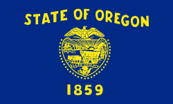 Flag 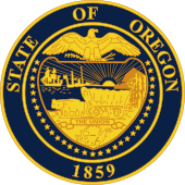 Seal | |
| Nickname(s): The Beaver State | |
| Motto(s): Alis volat propriis (English: She flies with her own wings) | |
| Anthem: Oregon, My Oregon | |
 Map of the United States with Oregon highlighted | |
| Country | United States |
| Before statehood | Oregon Territory |
| Admitted to the Union | February 14, 1859 (33rd) |
| Capital | Salem |
| Largest city | Portland |
| Largest metro | Portland metropolitan area |
| Government | |
| • Governor | Kate Brown (D) |
| • Secretary of State | Beverly Clarno (R) |
| Legislature | Legislative Assembly |
| • Upper house | State Senate |
| • Lower house | House of Representatives |
| U.S. senators | Ron Wyden (D) Jeff Merkley (D) |
| U.S. House delegation | 4 Democrats 1 Republican (list) |
| Area | |
| • Total | 98,381 sq mi (254,806 km2) |
| • Land | 95,997 sq mi (248,849 km2) |
| • Water | 2,384 sq mi (6,177 km2) 2.4% |
| Area rank | 9th |
| Dimensions | |
| • Length | 360 mi (580 km) |
| • Width | 400 mi (640 km) |
| Elevation | 3,300 ft (1,000 m) |
| Highest elevation | 11,249 ft (3,428.8 m) |
| Lowest elevation (Pacific Ocean[2]) | 0 ft (0 m) |
| Population (2019) | |
| • Total | 4,217,737 |
| • Rank | 27th |
| • Density | 39.9/sq mi (15.0/km2) |
| • Density rank | 39th |
| • Median household income | $60,212[4] |
| • Income rank | 21st |
| Demonym(s) | Oregonian |
| Language | |
| • Official language | De jure: none[5] De facto: Pacific Northwest English |
| Time zones | |
| primary | UTC−08:00 (Pacific) |
| • Summer (DST) | UTC−07:00 (PDT) |
| primary for Malheur County | UTC−07:00 (Mountain) |
| • Summer (DST) | UTC−06:00 (MDT) |
| USPS abbreviation | OR |
| ISO 3166 code | US-OR |
| Trad. abbreviation | Ore. |
| Latitude | 42° N to 46°18′ N |
| Longitude | 116°28′ W to 124°38′ W |
| Website | www |
| Oregon state symbols | |
|---|---|
The Flag of Oregon | |
The Seal of Oregon | |
| Living insignia | |
| Bird | Western meadowlark (Sturnella neglecta) |
| Crustacean | Dungeness crab (Metacarcinus magister) |
| Fish | Chinook salmon (Oncorhynchus tshawytscha) |
| Flower | Oregon grape (Mahonia aquifolium) |
| Grass | Bluebunch wheatgrass (Pseudoroegneria spicata) |
| Insect | Oregon swallowtail (Papilio oregonius) |
| Mammal | American beaver (Castor canadensis) |
| Tree | Douglas-fir |
| Inanimate insignia | |
| Beverage | Milk |
| Dance | Square dance |
| Food | Pear (Pyrus) |
| Fossil | Metasequoia |
| Gemstone | Oregon sunstone |
| Rock | Thunderegg |
| Shell | Oregon hairy triton (Fusitriton oregonensis) |
| Slogan | The Union |
| Soil | Jory soil |
| Other | Nut: Hazelnut |
| State route marker | |
 | |
| State quarter | |
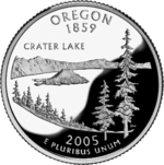 Released in 2005 | |
| Lists of United States state symbols | |
Oregon was inhabited by many indigenous tribes before European traders, explorers, and settlers arrived. An autonomous government was formed in the Oregon Country in 1843 before the Oregon Territory was created in 1848. Oregon became the 33rd state on February 14, 1859. Today, at 98,000 square miles (250,000 km2), Oregon is the ninth largest and, with a population of 4 million, 27th most populous U.S. state. The capital, Salem, is the second most populous city in Oregon, with 169,798 residents. Portland, with 647,805, ranks as the 26th among U.S. cities. The Portland metropolitan area, which also includes the city of Vancouver, Washington, to the north, ranks the 25th largest metro area in the nation, with a population of 2,453,168.
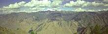
Oregon is one of the most geographically diverse states in the U.S.,[7] marked by volcanoes, abundant bodies of water, dense evergreen and mixed forests, as well as high deserts and semi-arid shrublands. At 11,249 feet (3,429 m), Mount Hood, a stratovolcano, is the state's highest point. Oregon's only national park, Crater Lake National Park, comprises the caldera surrounding Crater Lake, the deepest lake in the United States. The state is also home to the single largest organism in the world, Armillaria ostoyae, a fungus that runs beneath 2,200 acres (8.9 km2) of the Malheur National Forest.[8]
Because of its diverse landscapes and waterways, Oregon's economy is largely powered by various forms of agriculture, fishing, and hydroelectric power. Oregon is also the top timber producer of the contiguous United States, and the timber industry dominated the state's economy in the 20th century.[9] Technology is another one of Oregon's major economic forces, beginning in the 1970s with the establishment of the Silicon Forest and the expansion of Tektronix and Intel. Sportswear company Nike, Inc., headquartered in Beaverton, is the state's largest public corporation with an annual revenue of $30.6 billion.[10]
Etymology
_at_the_end_of_Nevada_State_Route_292_(Denio_Road)_at_the_Oregon_border_in_Denio%2C_Nevada.JPG)
The earliest evidence of the name Oregon has Spanish origins. The term "orejón" comes from the historical chronicle Relación de la Alta y Baja California (1598)[11] written by the new Spaniard Rodrigo Montezuma and made reference to the Columbia River when the Spanish explorers penetrated into the actual North American territory that became part of the Viceroyalty of New Spain. This chronicle is the first topographical and linguistic source with respect to the place name Oregon. There are also two other sources with Spanish origins, such as the word oregano, referring to a plant which grows in the southern part of the region. It is possible that the American territory was named by the Spaniards, as there is a stream in Spain called the "Arroyo del Oregón" (which is located in the province of Ciudad Real); it is also possible that the "j" in the Spanish phrase "El Orejón" was later corrupted into a "g",[12] and in context might refer to the 'earful' of the massive Columbia River at its mouth.
Another early use of the name, spelled Ouragon, was by Major Robert Rogers in a 1765 petition to the Kingdom of Great Britain. The term referred to the then-mythical River of the West (the Columbia River). By 1778, the spelling had shifted to Oregon.[13] Rogers wrote:
... from the Great Lakes towards the Head of the Mississippi, and from thence to the River called by the Indians Ouragon ...[14]
One theory is that the name comes from the French word ouragan ("windstorm" or "hurricane"), which was applied to the River of the West based on Native American tales of powerful Chinook winds on the lower Columbia River, or perhaps from firsthand French experience with the Chinook winds of the Great Plains. At the time, the River of the West was thought to rise in western Minnesota and flow west through the Great Plains.[15]
Joaquin Miller explained in Sunset magazine, in 1904, how Oregon's name was derived:
The name, Oregon, is rounded down phonetically, from Ouve água—Oragua, Or-a-gon, Oregon—given probably by the same Portuguese navigator that named the Farallones after his first officer, and it literally, in a large way, means cascades: "Hear the waters." You should steam up the Columbia and hear and feel the waters falling out of the clouds of Mount Hood to understand entirely the full meaning of the name Ouve a água, Oregon.[16]
Another account, endorsed as the "most plausible explanation" in the book Oregon Geographic Names, was advanced by George R. Stewart in a 1944 article in American Speech. According to Stewart, the name came from an engraver's error in a French map published in the early 18th century, on which the Ouisiconsink (Wisconsin) River was spelled "Ouaricon-sint", broken on two lines with the -sint below, so there appeared to be a river flowing to the west named "Ouaricon".
According to the Oregon Tourism Commission, present-day Oregonians /ˌɒrɪˈɡoʊniənz/[17] pronounce the state's name as "or-uh-gun, never or-ee-gone".[18] After being drafted by the Detroit Lions in 2002, former Oregon Ducks quarterback Joey Harrington distributed "Orygun" stickers to members of the media as a reminder of how to pronounce the name of his home state.[19][20] The stickers are sold by the University of Oregon Bookstore.[21]
Geography
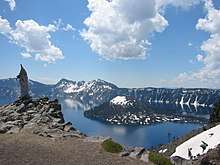
Oregon is 295 miles (475 km) north to south at longest distance, and 395 miles (636 km) east to west. With an area of 98,381 square miles (254,810 km2), Oregon is slightly larger than the United Kingdom. It is the ninth largest state in the United States.[22] Oregon's highest point is the summit of Mount Hood, at 11,249 feet (3,429 m), and its lowest point is the sea level of the Pacific Ocean along the Oregon Coast.[23] Oregon's mean elevation is 3,300 feet (1,006 m). Crater Lake National Park, the state's only national park, is the site of the deepest lake in the United States at 1,943 feet (592 m).[24] Oregon claims the D River as the shortest river in the world,[25] though the state of Montana makes the same claim of its Roe River.[26] Oregon is also home to Mill Ends Park (in Portland),[27] the smallest park in the world at 452 square inches (0.29 m2).
Oregon is split into eight geographical regions. In Western Oregon: Oregon Coast (west of the Coast Range), the Willamette Valley, Rogue Valley, Cascade Range and Klamath Mountains; and in Central and Eastern Oregon: the Columbia Plateau, the High Desert, and the Blue Mountains.
Oregon lies in two time zones. Most of Malheur County is in the Mountain Time Zone, while the rest of the state lies in the Pacific Time Zone.
Geology and terrain
.jpg)
Western Oregon's mountainous regions, home to three of the most prominent mountain peaks of the United States including Mount Hood, were formed by the volcanic activity of the Juan de Fuca Plate, a tectonic plate that poses a continued threat of volcanic activity and earthquakes in the region. The most recent major activity was the 1700 Cascadia earthquake. Washington's Mount St. Helens erupted in 1980, an event visible from northern Oregon and affecting some areas there.[28]
The Columbia River, which forms much of Oregon's northern border, also played a major role in the region's geological evolution, as well as its economic and cultural development. The Columbia is one of North America's largest rivers, and one of two rivers to cut through the Cascades (the Klamath River in southern Oregon is the other). About 15,000 years ago, the Columbia repeatedly flooded much of Oregon during the Missoula Floods; the modern fertility of the Willamette Valley is largely the result. Plentiful salmon made parts of the river, such as Celilo Falls, hubs of economic activity for thousands of years.
Today, Oregon's landscape varies from rain forest in the Coast Range to barren desert in the southeast, which still meets the technical definition of a frontier. Oregon's geographical center is further west than any of the other 48 contiguous states (although the westernmost point of the lower 48 states is in Washington). Central Oregon's geographical features range from high desert and volcanic rock formations resulting from lava beds. The Oregon Badlands Wilderness is in this region of the state.[29]
Flora and fauna
Typical of a western state, Oregon is home to a unique and diverse array of wildlife. Roughly 60 percent of the state is covered in forest,[30] while the areas west of the Cascades are more densely populated by forest, making up around 80 percent of the landscape. Some 60 percent of Oregon's forests are within federal land.[30] Oregon is the top timber producer of the lower 48 states.[9][31]
- Typical tree species include the Douglas fir (the state tree), as well as redwood, ponderosa pine, western red cedar, and hemlock.[32] Ponderosa pine are more common in the Blue Mountains in the eastern part of the state and firs are more common in the west.
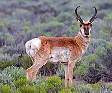
- Many species of mammals live in the state, which include opossums, shrews, moles, little pocket mice, great basin pocket mice, dark kangaroo mouse, California kangaroo rat, chisel-toothed kangaroo rat, ord's kangaroo rat,[33] bats, rabbits, pikas, mountain beavers, chipmunks, squirrels, yellow-bellied marmots, beavers (the state mammal), porcupines, coyotes, wolves, foxes[34] black bears, raccoons, badgers, skunks, antelopes, cougars, bobcats, lynxes, deer, elk, and moose.
- Marine mammals include seals, sea lions, humpback whales, killer whales, gray whales, blue whales, sperm whales, pacific white-sided dolphins, and bottlenose dolphins.[35]
- Notable birds include American widgeons, mallard ducks, great blue herons, bald eagles, golden eagles, western meadowlarks (the state bird), barn owls, great horned owls, rufous hummingbirds, pileated woodpeckers, wrens, towhees, sparrows, and buntings.[36]
Moose have not always inhabited the state but came to Oregon in the 1960s; the Wallowa Valley herd numbered about 60 as of 2013.[37] Gray wolves were extirpated from Oregon around 1930 but have since found their way back; most reside in northeast Oregon, with two packs living in the south-central part.[38] Although their existence in Oregon is unconfirmed, reports of grizzly bears still turn up, and it is probable some still move into eastern Oregon from Idaho.[39]
Oregon is home to what is considered the largest single organism in the world, an Armillaria solidipes fungus beneath the Malheur National Forest of eastern Oregon.[8]
Oregon has three national park sites: Crater Lake National Park in the southern part of the Cascades, John Day Fossil Beds National Monument east of the Cascades, and Lewis and Clark National and State Historical Parks on the north coast.[40][41]
Climate
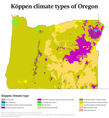
Most of Oregon has a generally mild climate, though there is significant variation given the variety of landscapes across the state.[42] The state's western region (west of the Cascade Range) has an oceanic climate, populated by dense evergreen mixed forests. Western Oregon's climate is heavily influenced by the Pacific Ocean; the western third of Oregon is very wet in the winter, moderately to very wet during the spring and fall, and dry during the summer. The relative humidity of Western Oregon is high except during summer days, which are semi-dry to semi-humid; Eastern Oregon typically sees low humidity year-round.[43]
The state's southwestern portion, particularly the Rogue Valley, has a Mediterranean climate with drier and sunnier winters and hotter summers, similar to Northern California.[44]
Oregon's northeastern portion has a steppe climate, and its high terrain regions have a subarctic climate. Like Western Europe, Oregon, and the Pacific Northwest in general, is considered warm for its latitude, and the state has far milder winters at a given elevation than comparable latitudes elsewhere in North America, such as the Upper Midwest, Ontario, Quebec and New England.[43] However, the state ranks fifth for coolest summer temperatures of any state in the country, after Maine, Idaho, Wyoming, and Alaska.[45]
The eastern two thirds of Oregon, which largely comprise high desert, have cold, snowy winters and very dry summers. Much of the east is semiarid to arid like the rest of the Great Basin, though the Blue Mountains are wet enough to support extensive forests. Most of Oregon receives significant snowfall, but the Willamette Valley, where 60 percent of the population lives,[46] has considerably milder winters for its latitude and typically sees only light snowfall.[43]
Oregon's highest recorded temperature is 119 °F (48 °C) at Pendleton on August 10, 1898, and the lowest recorded temperature is −54 °F (−48 °C) at Seneca on February 10, 1933.[47]
History
Humans have inhabited the area that is now Oregon for at least 15,000 years. In recorded history, mentions of the land date to as early as the 16th century. During the 18th and 19th centuries, European powers—and later the United States—quarreled over possession of the region until 1846, when the U.S. and Great Britain finalized division of the region. Oregon became a state on February 14, 1859, and as of 2015 has more than four million residents.[48]
Earliest inhabitants
.jpg)
While there is considerable evidence that Paleo-Indians inhabited the region, the oldest evidence of habitation in Oregon was found at Fort Rock Cave and the Paisley Caves in Lake County. Archaeologist Luther Cressman dated material from Fort Rock to 13,200 years ago,[49] and there is evidence supporting inhabitants in the region at least 15,000 years ago.[50] By 8000 BC there were settlements throughout the state, with populations concentrated along the lower Columbia River, in the western valleys, and around coastal estuaries.
During the prehistoric period, the Willamette Valley region was flooded after the collapse of glacial dams from then Lake Missoula, located in what would later become Montana. These massive floods occurred during the last glacial period and filled the valley with 300 to 400 feet (91 to 122 m) of water.[51]
By the 16th century, Oregon was home to many Native American groups, including the Chinook, Coquille (Ko-Kwell), Bannock, Chasta, Kalapuya, Klamath, Klickitat, Molalla, Nez Perce, Takelma, Killamuk, Neah-kah-nie, Umatilla, and Umpqua.[52][53][54][55]
European and pioneer settlement
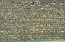
The first Europeans to visit Oregon were Spanish explorers led by Juan Rodríguez Cabrillo, who sighted southern Oregon off the Pacific coast in 1543.[56] Sailing Golden Hind in search of the Strait of Anian, the English explorer and privateer Sir Francis Drake briefly sought shelter, anchoring at South Cove, Cape Arago, just south of Coos Bay, before sailing for what is now California.[57][58] Exploration continued routinely in 1774, starting with the expedition of the frigate Santiago by Juan José Pérez Hernández (see Spanish expeditions to the Pacific Northwest), and the coast of Oregon became a valuable trade route to Asia. In 1778, British captain James Cook also explored the coast.[59]
French Canadian and métis trappers and missionaries arrived in the eastern part of the state in the late 18th and early 19th centuries, many having travelled as members of the Lewis and Clark and 1811 Astor expeditions. Some stayed permanently, including Étienne Lussier, believed to be the first European farmer in the state of Oregon. The evidence of this French Canadian presence can be found in the numerous names of French origin in that part of the state, including Malheur Lake and the Malheur River, the Grande Ronde and Deschutes rivers, and the city of La Grande.
The Lewis and Clark Expedition travelled through northern Oregon also in search of the Northwest Passage. They built their winter fort in 1805–06 at Fort Clatsop, near the mouth of the Columbia River, staying at the encampment from December until March.[60]
British explorer David Thompson also conducted overland exploration. In 1811, while working for the North West Company, Thompson became the first European to navigate the entire Columbia River.[61] Stopping on the way, at the junction of the Snake River, he posted a claim to the region for Great Britain and the North West Company. Upon returning to Montreal, he publicized the abundance of fur-bearing animals in the area.[62]
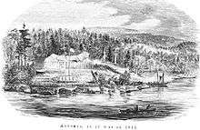
Also in 1811, New Yorker John Jacob Astor financed the establishment of Fort Astoria at the mouth of the Columbia River as a western outpost to his Pacific Fur Company;[63] this was the first permanent European settlement in Oregon.
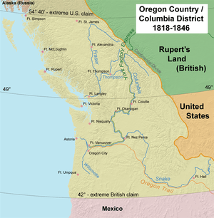
In the War of 1812, the British gained control of all Pacific Fur Company posts. The Treaty of 1818 established joint British and American occupancy of the region west of the Rocky Mountains to the Pacific Ocean. By the 1820s and 1830s, the Hudson's Bay Company dominated the Pacific Northwest from its Columbia District headquarters at Fort Vancouver (built in 1825 by the district's chief factor, John McLoughlin, across the Columbia from present-day Portland).
In 1841, the expert trapper and entrepreneur Ewing Young died leaving considerable wealth and no apparent heir, and no system to probate his estate. A meeting followed Young's funeral, at which a probate government was proposed.[64] Doctor Ira Babcock of Jason Lee's Methodist Mission was elected supreme judge.[65] Babcock chaired two meetings in 1842 at Champoeg, (halfway between Lee's mission and Oregon City), to discuss wolves and other animals of contemporary concern. These meetings were precursors to an all-citizen meeting in 1843, which instituted a provisional government headed by an executive committee made up of David Hill, Alanson Beers, and Joseph Gale.[66] This government was the first acting public government of the Oregon Country before annexation by the government of the United States. It was succeeded by a Second Executive Committee, made up of Peter G. Stewart, Osborne Russell, and William J. Bailey, and this committee was itself succeeded by George Abernethy, who was the first and only Governor of Oregon under the provisional government.
Also in 1841, Sir George Simpson, governor of the Hudson's Bay Company, reversed the Hudson's Bay Company's long-standing policy of discouraging settlement because it interfered with the lucrative fur trade.[67] He directed that some 200 Red River Colony settlers be relocated to HBC farms near Fort Vancouver, (the James Sinclair expedition), in an attempt to hold Columbia District.
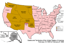
Starting in 1842–43, the Oregon Trail brought many new American settlers to the Oregon Country. For some time, it seemed that Britain and the United States would go to war for a third time in 75 years (see Oregon boundary dispute), but the border was defined peacefully in 1846 by the Oregon Treaty. The border between the United States and British North America was set at the 49th parallel.[68] The Oregon Territory was officially organized on August 13, 1848.[69]
Settlement increased with the Donation Land Claim Act of 1850 and the forced relocation of the native population to Indian reservations in Oregon.
Statehood
In December 1844, Oregon passed its Black Exclusion Law, which prohibited African Americans from entering the territory while simultaneously prohibiting slavery. Slave owners who brought their slaves with them were given three years before they were forced to free them. Any African Americans in the region after the law was passed were forced to leave, and those who did not comply were arrested and beaten. They received no less than twenty and no more than thirty-nine stripes across their bare back. If they still did not leave, this process could be repeated every six months.[70] Slavery played a major part in Oregon's history and even influenced its path to statehood. The territory's request for statehood was delayed several times, as members of Congress argued among themselves whether the territory should be admitted as a "free" or "slave" state. Eventually politicians from the south agreed to allow Oregon to enter as a "free" state, in exchange for opening slavery to the southwest United States.[71]
Oregon was admitted to the Union on February 14, 1859. Founded as a refuge from disputes over slavery, Oregon had a "whites only" clause in its original state Constitution.[72] At the outbreak of the American Civil War, regular U.S. troops were withdrawn and sent east. Volunteer cavalry recruited in California were sent north to Oregon to keep peace and protect the populace. The First Oregon Cavalry served until June 1865.
Post-Reconstruction
Beginning in the 1880s, the growth of railroads expanded the state's lumber, wheat, and other agricultural markets, and the rapid growth of its cities.[73] Due to the abundance of timber and waterway access via the Willamette River, Portland became a major force in the lumber industry of the Pacific Northwest, and quickly became the state's largest city. It would earn the nickname "Stumptown",[74] and would later become recognized as one of the most dangerous port cities in the United States due to racketeering and illegal activities at the turn of the 20th century.[75] In 1902, Oregon introduced direct legislation by the state's citizens through initiatives and referenda, known as the Oregon System.[76]
On May 5, 1945, six civilians were killed by a Japanese balloon bomb that exploded on Gearhart Mountain near Bly.[77][78] They remained the only people on American soil whose deaths were attributed to an enemy balloon bomb explosion during World War II. The bombing site is now located in the Mitchell Recreation Area.
.jpg)
Industrial expansion began in earnest following the 1933–37 construction of the Bonneville Dam on the Columbia River. Hydroelectric power, food, and lumber provided by Oregon helped fuel the development of the West, although the periodic fluctuations in the U.S. building industry have hurt the state's economy on multiple occasions. Portland in particular experienced a population boom between 1900 and 1930, tripling in size; the arrival of World War II also provided the northwest region of the state with an industrial boom, where Liberty ships and aircraft carriers were constructed.[79]
During the 1970s, the Pacific Northwest was particularly affected by the 1973 oil crisis, with Oregon suffering a substantial shortage.[80]
In 1994, Oregon became the first U.S. state to legalize physician-assisted suicide through the Oregon Death with Dignity Act. A measure to legalize recreational use of marijuana in Oregon was approved on November 4, 2014, making Oregon only the second state at the time to have legalized gay marriage, physician-assisted suicide, and recreational marijuana.[81]
Cities and towns
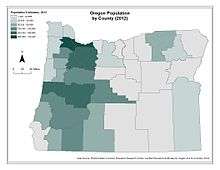
Oregon's population is largely concentrated in the Willamette Valley, which stretches from Eugene in the south (home of the University of Oregon) through Corvallis (home of Oregon State University) and Salem (the capital) to Portland (Oregon's largest city).[82]
Astoria, at the mouth of the Columbia River, was the first permanent English-speaking settlement west of the Rockies in what is now the United States. Oregon City, at the end of the Oregon Trail, was the Oregon Territory's first incorporated city, and was its first capital from 1848 until 1852, when the capital was moved to Salem. Bend, near the geographic center of the state, is one of the ten fastest-growing metropolitan areas in the United States.[83] In southern Oregon, Medford is a rapidly growing metro area and is home to the Rogue Valley International-Medford Airport, the state's third-busiest airport. To the south, near the California border, is the city of Ashland. Eastern Oregon is very sparsely populated, but is home to Hermiston, which with a population of 18,000 is the largest and fastest growing city in the region.[84]
Law and government
A writer in the Oregon Country book A Pacific Republic, written in 1839, predicted the territory was to become an independent republic. Four years later, in 1843, settlers of the Willamette Valley voted in majority for a republic government.[87] The Oregon Country functioned in this way until August 13, 1848, when Oregon was annexed by the United States and a territorial government was established. Oregon maintained a territorial government until February 14, 1859, when it was granted statehood.[88]
Oregon state government has a separation of powers similar to the federal government. It has three branches:
- a legislative branch (the bicameral Oregon Legislative Assembly),
- an executive branch which includes an "administrative department" and Oregon's governor serving as chief executive, and
- a judicial branch, headed by the Chief Justice of the Oregon Supreme Court.
Governors in Oregon serve four-year terms and are limited to two consecutive terms, but an unlimited number of total terms. Oregon has no lieutenant governor; in the event that the office of governor is vacated, Article V, Section 8a of the Oregon Constitution specifies that the Secretary of State is first in line for succession.[89] The other statewide officers are Treasurer, Attorney General, Superintendent, and Labor Commissioner. The biennial Oregon Legislative Assembly consists of a thirty-member Senate and a sixty-member House. The state supreme court has seven elected justices, currently including the only two openly gay state supreme court justices in the nation. They choose one of their own to serve a six-year term as Chief Justice.
The debate over whether to move to annual sessions is a long-standing battle in Oregon politics, but the voters have resisted the move from citizen legislators to professional lawmakers. Because Oregon's state budget is written in two-year increments and, there being no sales tax, state revenue is based largely on income taxes, it is often significantly over- or under-budget. Recent legislatures have had to be called into special session repeatedly to address revenue shortfalls resulting from economic downturns, bringing to a head the need for more frequent legislative sessions. Oregon Initiative 71, passed in 2010, mandates the legislature to begin meeting every year, for 160 days in odd-numbered years, and 35 days in even-numbered years.
| Federally recognized tribes in Oregon | |
|---|---|
| Burns Paiute Tribe | |
| Confederated Tribes of Coos, Lower Umpqua and Siuslaw Indians | |
| Confederated Tribes of Grand Ronde | |
| Confederated Tribes of Siletz Indians | |
| Confederated Tribes of Warm Springs | |
| Confederated Tribes of the Umatilla Indian Reservation | |
| Cow Creek Band of Umpqua Tribe of Indians | |
| Klamath Tribes | |
| Coquille Indian Tribe | |
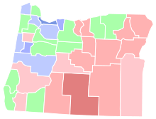
Oregonians have voted for the Democratic presidential candidate in every election since 1988. In 2004 and 2006, Democrats won control of the state Senate, and then the House. Since the late 1990s, Oregon has been represented by four Democrats and one Republican in the U.S. House of Representatives. Since 2009, the state has had two Democratic U.S. senators, Ron Wyden and Jeff Merkley. Oregon voters have elected Democratic governors in every election since 1986, most recently electing Kate Brown over Republican Bud Pierce in a 2016 special election for a two-year term, and re-electing her for a full four-year term over Republican Knute Buehler in 2018.
The base of Democratic support is largely concentrated in the urban centers of the Willamette Valley. The eastern two-thirds of the state beyond the Cascade Mountains typically votes Republican; in 2000 and 2004, George W. Bush carried every county east of the Cascades. However, the region's sparse population means the more populous counties in the Willamette Valley usually outweigh the eastern counties in statewide elections.
In the 2002 general election, Oregon voters approved a ballot measure to increase the state minimum wage automatically each year according to inflationary changes, which are measured by the consumer price index (CPI).[90] In the 2004 general election, Oregon voters passed ballot measures banning same-sex marriage[91] and restricting land use regulation.[92] In the 2006 general election, voters restricted the use of eminent domain and extended the state's discount prescription drug coverage.[93]
Federal representation
Like all U.S. states, Oregon is represented by two senators. Since the 1980 census, Oregon has had five congressional districts. After Oregon was admitted to the Union, it began with a single member in the House of Representatives (La Fayette Grover, who served in the 35th United States Congress for less than a month). Congressional apportionment increased the size of the delegation following the censuses of 1890, 1910, 1940, and 1980. A detailed list of the past and present Congressional delegations from Oregon is available.
The United States District Court for the District of Oregon hears federal cases in the state. The court has courthouses in Portland, Eugene, Medford, and Pendleton. Also in Portland is the federal bankruptcy court, with a second branch in Eugene.[94] Oregon (among other western states and territories) is in the 9th Court of Appeals. One of the court's meeting places is at the Pioneer Courthouse in downtown Portland, a National Historic Landmark built in 1869.
Politics
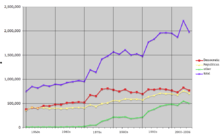
| Year | Democratic | Republican |
|---|---|---|
| 1950 | 34.0% 171,750 | 66.0% 334,160 |
| 1954 | 43.1% 244,170 | 56.9% 322,522 |
| 1958 | 44.7% 267,934 | 55.3% 331,900 |
| 1962 | 41.6% 265,359 | 54.2% 345,497 |
| 1966 | 44.7% 305,008 | 55.3% 377,346 |
| 1970 | 44.2% 293,892 | 55.6% 369,964 |
| 1974 | 57.7% 444,812 | 42.1% 324,751 |
| 1978 | 45.1% 409,411 | 54.9% 498,452 |
| 1982 | 35.9% 374,316 | 61.4% 639,841 |
| 1986 | 51.9% 549,456 | 47.9% 506,989 |
| 1990 | 45.7% 508,749 | 40.0% 444,646 |
| 1994 | 51.0% 622,083 | 42.4% 517,874 |
| 1998 | 64.4% 717,061 | 30.0% 334,001 |
| 2002 | 49.0% 618,004 | 46.2% 581,785 |
| 2006 | 50.7% 699,786 | 42.8% 589,748 |
| 2010 | 49.3% 716,525 | 47.8% 694,287 |
| 2014 | 49.9% 733,230 | 44.1% 648,542 |
| 2016 | 50.6% 985,027 | 43.4% 845,609 |
| 2018 | 50.1% 934,498 | 43.7% 814,988 |
| Year | Democratic | Republican |
|---|---|---|
| 1952 | 38.9% 270,579 | 60.5% 420,815 |
| 1956 | 44.8% 329,204 | 55.3% 406,393 |
| 1960 | 47.3% 367,402 | 52.6% 408,060 |
| 1964 | 63.7% 501,017 | 36.0% 282,779 |
| 1968 | 43.8% 358,866 | 49.8% 408,433 |
| 1972 | 42.3% 392,760 | 52.5% 486,686 |
| 1976 | 47.6% 490,407 | 47.8% 492,120 |
| 1980 | 38.7% 456,890 | 48.3% 571,044 |
| 1984 | 43.7% 536,479 | 55.9% 685,700 |
| 1988 | 51.3% 616,206 | 46.6% 560,126 |
| 1992 | 42.5% 621,314 | 32.5% 475,757 |
| 1996 | 47.2% 649,641 | 39.1% 538,152 |
| 2000 | 47.0% 720,342 | 46.5% 713,577 |
| 2004 | 51.4% 943,163 | 47.2% 866,831 |
| 2008 | 56.8% 1,037,291 | 40.4% 738,475 |
| 2012 | 54.3% 970,343 | 42.2% 754,095 |
| 2016 | 50.1% 1,002,106 | 39.1% 782,403 |
Political opinions in Oregon are geographically split by the Cascade Range, with western Oregon being more liberal and Eastern Oregon being conservative.[96] In a 2008 analysis of the 2004 presidential election, a political analyst found that according to the application of a Likert scale, Oregon boasted both the most liberal Kerry voters and the most conservative Bush voters, making it the most politically polarized state in the country.[97]
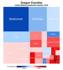
While Republicans typically win more counties by running up huge margins in the east, the Democratic tilt of the more populated west is usually enough to swing the entire state Democratic. In 2008, for instance, Republican Senate incumbent Gordon H. Smith lost his bid for a third term, even though he carried all but eight counties. His Democratic challenger, Jeff Merkley, won Multnomah County by 142,000 votes, more than double the overall margin of victory.
During Oregon's history, it has adopted many electoral reforms proposed during the Progressive Era, through the efforts of William S. U'Ren and his Direct Legislation League. Under his leadership, the state overwhelmingly approved a ballot measure in 1902 that created the initiative and referendum for citizens to introduce or approve proposed laws or amendments to the state constitution directly, making Oregon the first state to adopt such a system. Today, roughly half of U.S. states do so.[98]
In following years, the primary election to select party candidates was adopted in 1904, and in 1908 the Oregon Constitution was amended to include recall of public officials. More recent amendments include the nation's first doctor-assisted suicide law,[99] called the Death with Dignity Act (which was challenged, unsuccessfully, in 2005 by the Bush administration in a case heard by the U.S. Supreme Court), legalization of medical cannabis, and among the nation's strongest anti-urban sprawl and pro-environment laws. More recently, 2004's Measure 37 reflects a backlash against such land-use laws. However, a further ballot measure in 2007, Measure 49, curtailed many of the provisions of 37.
Of the measures placed on the ballot since 1902, the people have passed 99 of the 288 initiatives and 25 of the 61 referendums on the ballot, though not all of them survived challenges in courts (see Pierce v. Society of Sisters, for an example). During the same period, the legislature has referred 363 measures to the people, of which 206 have passed.
Oregon pioneered the American use of postal voting, beginning with experimentation approved by the Oregon Legislative Assembly in 1981 and culminating with a 1998 ballot measure mandating that all counties conduct elections by mail. It remains one of just two states, the other being Washington, where voting by mail is the only method of voting.
In 1994, Oregon adopted the Oregon Health Plan, which made health care available to most of its citizens without private health insurance.[100]
In the U.S. Electoral College, Oregon casts seven votes. Oregon has supported Democratic candidates in the last eight elections. Democratic incumbent Barack Obama won the state by a margin of twelve percentage points, with over 54% of the popular vote in 2012. In the 2016 election, Hillary Clinton won Oregon by 11 percentage points.[101]
Economy
- Total Employment (2016): 1,551,192
- Number of employer establishments (2016): 114,551[102]
As of 2015, Oregon ranks as the 17th highest in median household income at $60,834.[4] The gross domestic product (GDP) of Oregon in 2013 was $219.6 billion, a 2.7% increase from 2012; Oregon is the 25th wealthiest state by GDP. In 2003, Oregon was 28th in the U.S. by GDP. The state's per capita personal income (PCPI) in 2013 was $39,848, a 1.5% increase from 2012. Oregon ranks 33rd in the U.S. by PCPI, compared to 31st in 2003. The national PCPI in 2013 was $44,765.[103]
Oregon's unemployment rate was 5.5% in September 2016,[104] while the U.S. unemployment rate was 5.0% that month.[105] Oregon has the third largest amount of food stamp users in the nation (21% of the population).[106]
Agriculture
.jpg)
Oregon's diverse landscapes provide ideal environments for various types of farming. Land in the Willamette Valley owes its fertility to the Missoula Floods, which deposited lake sediment from Glacial Lake Missoula in western Montana onto the valley floor.[107] In 2016, the Willamette Valley region produced over 100 million pounds (45 kt) of blueberries.[108]
Oregon is also one of four major world hazelnut growing regions, and produces 95% of the domestic hazelnuts in the United States. While the history of the wine production in Oregon can be traced to before Prohibition, it became a significant industry beginning in the 1970s. In 2005, Oregon ranked third among U.S. states with 303 wineries.[109] Due to regional similarities in climate and soil, the grapes planted in Oregon are often the same varieties found in the French regions of Alsace and Burgundy. In 2014, 71 wineries opened in the state. The total is currently 676, which represents growth of 12% over 2013.[110]
In the southern Oregon coast, commercially cultivated cranberries account for about 7 percent of U.S. production, and the cranberry ranks 23rd among Oregon's top 50 agricultural commodities. Cranberry cultivation in Oregon uses about 27,000 acres (110 square kilometers) in southern Coos and northern Curry counties, centered around the coastal city of Bandon. In the northeastern region of the state, particularly around Pendleton, both irrigated and dry land wheat is grown.[111] Oregon farmers and ranchers also produce cattle, sheep, dairy products, eggs and poultry.
Forestry and fisheries

Vast forests have historically made Oregon one of the nation's major timber-producing and logging states, but forest fires (such as the Tillamook Burn), over-harvesting, and lawsuits over proper management of the extensive federal forest holdings have reduced the timber produced. Between 1989 and 2011, the amount of timber harvested from federal lands in Oregon dropped about 90%, although harvest levels on private land have remained relatively constant.[112]
Even the shift in recent years towards finished goods such as paper and building materials has not slowed the decline of the timber industry in the state. The effects of this decline have included Weyerhaeuser's acquisition of Portland-based Willamette Industries in January 2002, the relocation of Louisiana-Pacific's corporate headquarters from Portland to Nashville, and the decline of former lumber company towns such as Gilchrist. Despite these changes, Oregon still leads the United States in softwood lumber production; in 2011, 4,134 million board feet (9,760,000 m3) was produced in Oregon, compared with 3,685 million board feet (8,700,000 m3) in Washington, 1,914 million board feet (4,520,000 m3) in Georgia, and 1,708 million board feet (4,030,000 m3) in Mississippi.[113] The slowing of the timber and lumber industry has caused high unemployment rates in rural areas.[114]
Oregon has one of the largest salmon-fishing industries in the world, although ocean fisheries have reduced the river fisheries in recent years.[115] Because of the abundance of waterways in the state, it is also a major producer of hydroelectric energy.[116]
Tourism and entertainment
Tourism is also a strong industry in the state. Tourism is centered on the state's natural features – mountains, forests, waterfalls, rivers, beaches and lakes, including Crater Lake National Park, Multnomah Falls, the Painted Hills, the Deschutes River, and the Oregon Caves. Mount Hood and Mount Bachelor also draw visitors year-round for skiing and other snow activities.[117]

Portland is home to the Oregon Museum of Science and Industry, the Portland Art Museum, and the Oregon Zoo, which is the oldest zoo west of the Mississippi River.[118] The International Rose Test Garden is another prominent attraction in the city. Portland has also been named the best city in the world for street food by several publications, including the U.S. News & World Report and CNN.[119][120] Oregon is home to many breweries, and Portland has the largest number of breweries of any city in the world.[121]
The state's coastal region produces significant tourism as well.[122] The Oregon Coast Aquarium comprises 23 acres (9.3 ha) along Yaquina Bay in Newport, and was also home to Keiko the orca whale.[123] It has been noted as one of the top ten aquariums in North America.[124] Fort Clatsop in Warrenton features a replica of Lewis and Clark's encampment at the mouth of the Columbia River in 1805. The Sea Lion Caves in Florence are the largest system of sea caverns in the United States, and also attract many visitors.[125]
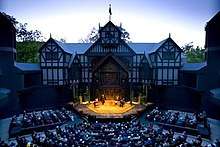
In Southern Oregon, the Oregon Shakespeare Festival, held in Ashland, is also a tourist draw, as is the Oregon Vortex and the Wolf Creek Inn State Heritage Site, a historic inn where Jack London wrote his 1913 novel Valley of the Moon.[126]
Oregon has also historically been a popular region for film shoots due to its diverse landscapes, as well as its proximity to Hollywood (see List of films shot in Oregon).[127] Movies filmed in Oregon include: Animal House, Free Willy, The General, The Goonies, Kindergarten Cop, One Flew Over the Cuckoo's Nest, and Stand By Me. Oregon native Matt Groening, creator of The Simpsons, has incorporated many references from his hometown of Portland into the TV series.[128] Additionally, several television shows have been filmed throughout the state including Portlandia, Grimm, Bates Motel, and Leverage.[129] The Oregon Film Museum is located in the old Clatsop County Jail in Astoria.
Technology
High technology industries located in Silicon Forest have been a major employer since the 1970s. Tektronix was the largest private employer in Oregon until the late 1980s. Intel's creation and expansion of several facilities in eastern Washington County continued the growth that Tektronix had started. Intel, the state's largest for-profit private employer,[130][131] operates four large facilities, with Ronler Acres, Jones Farm and Hawthorn Farm all located in Hillsboro.[132]
The spinoffs and startups that were produced by these two companies led to establishment of the so-called Silicon Forest. The recession and dot-com bust of 2001 hit the region hard; many high technology employers reduced the number of their employees or went out of business. Open Source Development Labs made news in 2004 when they hired Linus Torvalds, developer of the Linux kernel. In 2010, biotechnology giant Genentech opened a $400 million facility in Hillsboro to expand its production capabilities.[133] Oregon is home to several large datacenters that take advantage of cheap power and a climate conducive to reducing cooling costs. Google operates a large datacenter in The Dalles, and Facebook built a large datacenter near Prineville in 2010. Amazon opened a datacenter near Boardman in 2011, and a fulfillment center in Troutdale in 2018.[134][135]
Corporate headquarters

| Corporation | Headquarters | Market cap (USD$billion) |
|---|---|---|
| 1. Nike | Beaverton | 91.35 |
| 2. FLIR Systems | Wilsonville | 4.77 |
| 3. Portland General Electric | Portland | 4.05 |
| 4. Columbia Sportswear | Beaverton | 4.03 |
| 5. Umpqua Holdings Corporation | Portland | 3.68 |
| 6. Lithia Motors | Medford | 2.06 |
| 7. Northwest Natural Gas | Portland | 1.7 |
| 8. The Greenbrier Companies | Lake Oswego | 1.25 |
Oregon is also the home of large corporations in other industries. The world headquarters of Nike are located near Beaverton. Medford is home to Harry and David, which sells gift items under several brands. Medford is also home to the national headquarters of Lithia Motors. Portland is home to one of the West's largest trade book publishing houses, Graphic Arts Center Publishing. Oregon is also home to Mentor Graphics Corporation, a world leader in electronic design automation located in Wilsonville and employs roughly 4,500 people worldwide.
Adidas Corporations American Headquarters is located in Portland and employs roughly 900 full-time workers at its Portland campus.[137] Nike, located in Beaverton, employs roughly 5,000 full-time employees at its 200-acre (81 ha) campus. Nike's Beaverton campus is continuously ranked as a top employer in the Portland area-along with competitor Adidas.[138] Intel Corporation employs 18,600 in Oregon[131] with the majority of these employees located at the company's Hillsboro campus located about 30 minutes west of Portland. Intel has been a top employer in Oregon since 1974.[139]
The U.S. Federal Government and Providence Health systems are respective contenders for top employers in Oregon with roughly 12,000 federal workers and 14,000 Providence Health workers.
In 2015, a total of seven companies headquartered in Oregon landed in the Fortune 1000: Nike, at 106; Precision Castparts Corp. at 302; Lithia Motors at 482; StanCorp Financial Group at 804; Schnitzer Steel Industries at 853; The Greenbrier Companies at 948; and Columbia Sportswear at 982.[140]
Taxes and budgets
Oregon's biennial state budget, $2.6 billion in 2017, comprises General Funds, Federal Funds, Lottery Funds, and Other Funds.[141]
Oregon is one of only five states that have no sales tax.[142] Oregon voters have been resolute in their opposition to a sales tax, voting proposals down each of the nine times they have been presented.[143] The last vote, for 1993's Measure 1, was defeated by a 75–25% margin.[144]
The state also has a minimum corporate tax of only $150 a year,[145] amounting to 5.6% of the General Fund in the 2005–07 biennium; data about which businesses pay the minimum is not available to the public.[146] As a result, the state relies on property and income taxes for its revenue. Oregon has the fifth highest personal income tax in the nation. According to the U.S. Census Bureau, Oregon ranked 41st out of the 50 states in taxes per capita in 2005 with an average amount paid of 1,791.45.[147]
A few local governments levy sales taxes on services: the city of Ashland, for example, collects a 5% sales tax on prepared food.[148]
The City of Portland imposes an Arts Education and Access Income Tax on residents over 18—a flat tax of $35 collected from individuals earning $1,000 or more per year and residing in a household with an annual income exceeding the federal poverty level. The tax funds Portland school teachers, and art focused non-profit organizations in Portland.[149]
The State of Oregon also allows transit district to levy an income tax on employers and the self-employed. The State currently collects the tax for TriMet and the Lane Transit District.[150][151]
Oregon is one of six states with a revenue limit.[152] The "kicker law" stipulates that when income tax collections exceed state economists' estimates by two percent or more, any excess must be returned to taxpayers.[153] Since the enactment of the law in 1979, refunds have been issued for seven of the eleven biennia.[154] In 2000, Ballot Measure 86 converted the "kicker" law from statute to the Oregon Constitution, and changed some of its provisions.
Federal payments to county governments that were granted to replace timber revenue when logging in National Forests was restricted in the 1990s, have been under threat of suspension for several years. This issue dominates the future revenue of rural counties, which have come to rely on the payments in providing essential services.[155]
55% of state revenues are spent on public education, 23% on human services (child protective services, Medicaid, and senior services), 17% on public safety, and 5% on other services.[156]
Healthcare
For health insurance, as of 2018 Cambia Health Solutions has the highest market share at 21%, followed by Providence Health.[157] In the Portland region, Kaiser Permanente leads.[157] Providence and Kaiser are vertically integrated delivery systems which operate hospitals and offer insurance plans.[158] Aside from Providence and Kaiser, hospital systems which are primarily Oregon-based include Legacy Health mostly covering Portland, Samaritan Health Services with five hospitals in various areas across the state, and Tuality Healthcare in the western Portland metropolitan area. In Southern Oregon, Asante runs several hospitals, including Rogue Regional Medical Center. Some hospitals are operated by multi-state organizations such as PeaceHealth and CommonSpirit Health. Some hospitals such Salem Hospital operate independently of larger systems.
Oregon Health & Science University is a Portland-based medical school which operates two hospitals and clinics.
The Oregon Health Plan is the state's Medicaid managed care plan, and it is known for innovations.[159] The Portland area is a mature managed care and two-thirds of Medicare enrollees are in Medicare Advantage plans.[159]
Demographics
Population
| Historical population | |||
|---|---|---|---|
| Census | Pop. | %± | |
| 1850 | 12,093 | — | |
| 1860 | 52,465 | 333.8% | |
| 1870 | 90,923 | 73.3% | |
| 1880 | 174,768 | 92.2% | |
| 1890 | 317,704 | 81.8% | |
| 1900 | 413,536 | 30.2% | |
| 1910 | 672,765 | 62.7% | |
| 1920 | 783,389 | 16.4% | |
| 1930 | 953,786 | 21.8% | |
| 1940 | 1,089,684 | 14.2% | |
| 1950 | 1,521,341 | 39.6% | |
| 1960 | 1,768,687 | 16.3% | |
| 1970 | 2,091,533 | 18.3% | |
| 1980 | 2,633,156 | 25.9% | |
| 1990 | 2,842,321 | 7.9% | |
| 2000 | 3,421,399 | 20.4% | |
| 2010 | 3,831,074 | 12.0% | |
| Est. 2019 | 4,217,737 | 10.1% | |
| Sources: 1910–2010[161] 2018 estimate[48] | |||
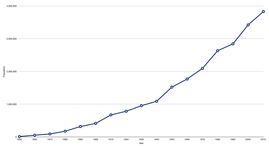
The United States Census Bureau estimates that the population of Oregon was 4,217,737 on July 1, 2019, a 10.09% increase over the 2010 census.[48]
Oregon was the nation's "Top Moving Destination" in 2014, with two families moving into the state for every one moving out (66.4% to 33.6%).[163] Oregon was also the top moving destination in 2013,[164] and the second-most popular destination in 2010 through 2012.[165][166]
As of the 2010 census, the population of Oregon was 3,831,074. The gender makeup of the state was 49.5% male and 50.5% female. 22.6% of the population were under the age of 18; 63.5% were between the ages of 18 and 64; and 12.5% were 65 years of age or older.[167]
The table below shows the racial composition of Oregon's population as of 2016.
| Race | Population (2016 est.) | Percentage |
|---|---|---|
| Total population | 3,982,267 | 100% |
| White | 3,387,825 | 85.1% |
| Black or African American | 74,012 | 1.9% |
| American Indian and Alaska Native | 45,233 | 1.1% |
| Asian | 160,155 | 4.0% |
| Native Hawaiian and Other Pacific Islander | 14,936 | 0.4% |
| Some other race | 124,565 | 3.1% |
| Two or more races | 175,541 | 4.4% |
| Racial composition | 1970[169] | 1990[169] | 2000[170] | 2010[167] |
|---|---|---|---|---|
| White | 97.2% | 92.8% | 86.6% | 83.6% |
| Black or African American | 1.3% | 1.6% | 1.6% | 1.8% |
| American Indian and Alaska Native | 0.6% | 1.4% | 1.3% | 1.4% |
| Asian | 0.7% | 2.4% | 3.0% | 3.7% |
| Native Hawaiian and Other Pacific Islander | – | – | 0.2% | 0.3% |
| Other race | 0.2% | 1.8% | 4.2% | 5.3% |
| Two or more races | – | – | 3.1% | 3.8% |
According to the 2016 American Community Survey, 12.4% of Oregon's population were of Hispanic or Latino origin (of any race): Mexican (10.4%), Puerto Rican (0.3%), Cuban (0.1%), and other Hispanic or Latino origin (1.5%).[168] The five largest ancestry groups were: German (19.1%), Irish (11.7%), English (11.3%), American (5.3%), and Norwegian (3.8%).[171]
The state's most populous ethnic group, non-Hispanic white, has declined from 95.8% in 1970 to 77.8% in 2012.[172][173]
As of 2011, 38.7% of Oregon's children under one year of age belonged to minority groups, meaning they had at least one parent who was not a non-Hispanic white.[174] Of the state's total population, 22.6% was under the age 18, and 77.4% were 18 or older.
The center of population of Oregon is located in Linn County, in the city of Lyons.[175] Around 60% of Oregon's population resides within the Portland metropolitan area.[176]
As of 2009, Oregon's population comprised 361,393 foreign-born residents.[177] Of the foreign-born residents, the three largest groups are originally from countries in: Latin America (47.8%), Asia (27.4%), and Europe (16.5%).[177]
Religious and secular communities
| Affiliation | % of Oregon population | |
|---|---|---|
| Christianity | 59 | |
| Protestant | 43 | |
| Evangelical Protestant | 29 | |
| Mainline Protestant | 13 | |
| Black Protestant | 1 | |
| Catholic | 12 | |
| Mormon | 4 | |
| Orthodox | 1 | |
| Jehovah's Witnesses | 0.5 | |
| Other Christianity | 1 | |
| Judaism | 2 | |
| Islam | 1 | |
| Buddhism | 0.5 | |
| Hinduism | 0.5 | |
| Other faiths | 3 | |
| No religion | 31 | |
| Don't know | 1 | |
| Total | 100 | |
Oregon has frequently been cited by statistical agencies for having a smaller percentage of religious communities than other U.S. states.[179][180] According to a 2009 Gallup poll, Oregon was paired with Vermont as the two "least religious" states in the United States.[181]
In the same 2009 Gallup poll, 69% of Oregonians identified themselves as being Christian.[182] The largest Christian denominations in Oregon by number of adherents in 2010 were the Roman Catholic Church with 398,738; The Church of Jesus Christ of Latter-day Saints with 147,965; and the Assemblies of God with 45,492.[183] Oregon also contains the largest community of Russian Old Believers to be found in the United States.[184] Judaism is the largest non-Christian religion in Oregon with more than 50,000 adherents, 47,000 of whom live in the Portland area.[185][186] Recently, new kosher food and Jewish educational offerings have led to a rapid increase in Portland's Orthodox Jewish population.[187] The Northwest Tibetan Cultural Association is headquartered in Portland. There are an estimated 6,000 to 10,000 Muslims in Oregon, most of whom live in and around Portland.[188]
Most of the remainder of the population had no religious affiliation; the 2008 American Religious Identification Survey (ARIS) placed Oregon as tied with Nevada in fifth place of U.S. states having the highest percentage of residents identifying themselves as "non-religious", at 24 percent.[189][190] Secular organizations include the Center for Inquiry (CFI), the Humanists of Greater Portland (HGP), and the United States Atheists (USA).
During much of the 1990s, a group of conservative Christians formed the Oregon Citizens Alliance, and unsuccessfully tried to pass legislation to prevent "gay sensitivity training" in public schools and legal benefits for homosexual couples.[191]
- Birth data
- Note: Births in table don't add up, because Hispanics are counted both by their ethnicity and by their race, giving a higher overall number.
| Race | 2013[192] | 2014[193] | 2015[194] | 2016[195] | 2017[196] | 2018[197] |
|---|---|---|---|---|---|---|
| White | 40,219 (89.1%) | 40,634 (89.2%) | 40,484 (88.7%) | ... | ... | ... |
| > Non-Hispanic White | 31,998 (70.8%) | 32,338 (71.0%) | 32,147 (70.4%) | 31,057 (68.2%) | 29,232 (67.0%) | 28,265 (67.0%) |
| Asian | 2,696 (6.0%) | 2,811 (6.2%) | 2,895 (6.3%) | 2,354 (5.2%) | 2,376 (5.4%) | 2,260 (5.4%) |
| Black | 1,331 (2.9%) | 1,333 (2.9%) | 1,463 (3.2%) | 944 (2.1%) | 994 (2.3%) | 959 (2.3%) |
| American Indian | 909 (2.0%) | 778 (1.7%) | 813 (1.8%) | 427 (0.9%) | 429 (1.0%) | 388 (0.9%) |
| Pacific Islander | ... | ... | ... | 315 (0.7%) | 300 (0.7%) | 309 (0.7%) |
| Hispanic (of any race) | 8,448 (18.7%) | 8,524 (18.7%) | 8,518 (18.6%) | 8,467 (18.6%) | 8,275 (19.0%) | 7,993 (18.9%) |
| Total | 45,155 (100%) | 45,556 (100%) | 45,655 (100%) | 45,535 (100%) | 43,631 (100%) | 42,188 (100%) |
- Since 2016, data for births of White Hispanic origin are not collected, but included in one Hispanic group; persons of Hispanic origin may be of any race.
Education
Elementary, middle, and high school
In the 2013–2014 school year, the state had 567,000 students in public schools.[200] There were 197 public school districts, served by 19 education service districts.[200]
In 2016, the largest school districts in the state were:[201] Portland Public Schools, comprising 47,323 students; Salem-Keizer School District, comprising 40,565 students; Beaverton School District, comprising 39,625 students; Hillsboro School District, comprising 21,118 students; and North Clackamas School District, comprising 17,053 students.
Colleges and universities
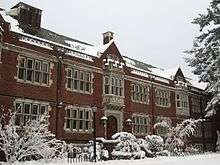
.JPG)

Especially since the 1990 passage of Measure 5, which set limits on property tax levels, Oregon has struggled to fund higher education. Since then, Oregon has cut its higher education budget and now ranks 46th in the country in state spending per student. However, 2007 legislation funded the university system far beyond the governor's requested budget though still capping tuition increases at 3% per year.[202] Oregon supports a total of seven public universities and one affiliate. It is home to three public research universities: The University of Oregon (UO) in Eugene and Oregon State University (OSU) in Corvallis, both classified as research universities with very high research activity, and Portland State University which is classified as a research university with high research activity.[203]
UO is the state's highest nationally-ranked and most selective[204] public university by U.S. News & World Report and Forbes.[205] OSU is the state's only land-grant university, has the state's largest enrollment for fall 2014,[206] and is the state's highest ranking university according to Academic Ranking of World Universities, Washington Monthly, and QS World University Rankings.[207] OSU receives more annual funding for research than all other public higher education institutions in Oregon combined.[208] The state's urban Portland State University has Oregon's second largest enrollment.
The state has three regional universities: Western Oregon University in Monmouth, Southern Oregon University in Ashland, and Eastern Oregon University in La Grande. The Oregon Institute of Technology has its campus in Klamath Falls. The quasi-public Oregon Health & Science University (OHSU) includes medical, dental, and nursing schools, and graduate programs in biomedical sciences in Portland and a science and engineering school in Hillsboro. The state also supports 17 community colleges.
Oregon is home to a wide variety of private colleges, the majority of which are located in the Portland area. The University of Portland and Marylhurst University are both Catholic universities located in or near Portland, affiliated with the Congregation of Holy Cross, and the Sisters of the Holy Names of Jesus and Mary, respectively. Reed College, a rigorous liberal arts college in Portland, was ranked by Forbes as the 52nd best college in the country in 2015.[209]
Other private institutions in Portland include Concordia University; Lewis & Clark College; Multnomah University; Portland Bible College; Warner Pacific College; Cascade College; the National University of Natural Medicine; and Western Seminary, a theological graduate school. Pacific University is in the Portland suburb of Forest Grove. There are also private colleges further south in the Willamette Valley. McMinnville is home to Linfield College, while nearby Newberg is home to George Fox University. Salem is home to two private schools: Willamette University (the state's oldest, established during the provisional period) and Corban University. Also located near Salem is Mount Angel Seminary, one of America's largest Roman Catholic seminaries. The state's second medical school, the College of Osteopathic Medicine of the Pacific, Northwest, is located in Lebanon. Eugene is home to three private colleges: Northwest Christian University, New Hope Christian College, and Gutenberg College.
Sports

Oregon is home to three major professional sports teams: the Portland Trail Blazers of the NBA, the Portland Thorns of the NWSL and the Portland Timbers of MLS.[210]
Until 2011, the only major professional sports team in Oregon was the Portland Trail Blazers of the National Basketball Association. From the 1970s to the 1990s, the Blazers were one of the most successful teams in the NBA in terms of both win-loss record and attendance.[211] In the early 21st century, the team's popularity declined due to personnel and financial issues, but revived after the departure of controversial players and the acquisition of new players such as Brandon Roy and LaMarcus Aldridge, and still later Damian Lillard.[212][213] The Blazers play in the Moda Center in Portland's Lloyd District, which also is home to the Portland Winterhawks of the junior Western Hockey League.[214]
The Portland Timbers play at Providence Park, just west of downtown Portland. The Timbers have a strong following, with the team regularly selling out its games.[215] The Timbers repurposed the formerly multi-use stadium into a soccer-specific stadium in fall 2010, increasing the seating in the process.[216] The Timbers operate Portland Thorns FC, a women's soccer team that has played in the National Women's Soccer League since the league's first season in 2013. The Thorns, who also play at Providence Park, have won two league championships, in the inaugural 2013 season and also in 2017, and have been by far the NWSL's attendance leader in each of the league's seasons.

Eugene, Salem and Hillsboro have minor-league baseball teams: the Eugene Emeralds, the Salem-Keizer Volcanoes, and the Hillsboro Hops all play in the Single-A Northwest League.[217] Portland has had minor-league baseball teams in the past, including the Portland Beavers and Portland Rockies, who played most recently at Providence Park when it was known as PGE Park.
The Oregon State Beavers and the University of Oregon Ducks football teams of the Pac-12 Conference meet annually in the Civil War. Both schools have had recent success in other sports as well: Oregon State won back-to-back college baseball championships in 2006 and 2007,[218] winning a third in 2018;[219] and the University of Oregon won back-to-back NCAA men's cross country championships in 2007 and 2008.[220]
Sister regions
- Fujian Province,

- Taiwan Province,

- Toyama Prefecture,
- Jeollanam-do Province,

- Iraqi Kurdistan,

See also
- Outline of Oregon (organized list of topics about Oregon)
- Index of Oregon-related articles
- Bibliography of Oregon history
Notes
- "Mount Hood Highest Point". NGS data sheet. U.S. National Geodetic Survey. Retrieved October 24, 2011.
- "Elevations and Distances in the United States". United States Geological Survey. 2001. Archived from the original on October 15, 2011. Retrieved October 24, 2011.
- Elevation adjusted to North American Vertical Datum of 1988.
- "Median Annual Household Income". The Henry J. Kaiser Foundation. Archived from the original on December 20, 2016. Retrieved December 9, 2016.
- Hall, Calvin (January 30, 2007). "English as Oregon's official language? It could happen". The Oregon Daily Emerald. Archived from the original on January 17, 2013. Retrieved May 8, 2007.
- Wells, John C. (2008). Longman Pronunciation Dictionary (3rd ed.). Longman. ISBN 978-1-4058-8118-0.
- Jewell & McRae 2014, p. 4.
- Beale, Bob (April 10, 2003). "Humungous fungus: world's largest organism?". Environment & Nature News. ABC. Archived from the original on December 31, 2006. Retrieved December 9, 2016.
- "Forest Land Protection Program". Oregon Department of Fish and Wildlife. Archived from the original on July 8, 2018. Retrieved November 7, 2016.
- "Financial Statements for Nike, Inc". Google Finance. Archived from the original on February 3, 2017. Retrieved April 17, 2017.
- Secretaría de Comunicaciones y Transportes 1988, p. 149.
- Johnson 1904, p. 51.
- "Oregon Blue Book: Oregon Almanac: Mountains to National Wildlife Refuges". Archived from the original on October 24, 2018. Retrieved October 23, 2018.
- Where does the name "Oregon" come from? Archived October 24, 2018, at the Wayback Machine from the online edition of the Oregon Blue Book.
- Elliott, T.C. (June 1921). "The Origin of the Name Oregon". Oregon Historical Quarterly. XXIII (2): 99–100. ISSN 0030-4727. OCLC 1714620. Archived from the original on September 5, 2015. Retrieved June 27, 2015 – via Google Books.

- Miller, Joaquin (September 1904). "The Sea of Silence". Sunset. XIII (5): 395–396 – via Google Books.
- "Oregon". Merriam-Webster Online Dictionary. Archived from the original on November 22, 2008. Retrieved September 14, 2006.
- "Oregon Fast Facts". Travel Oregon. Archived from the original on March 23, 2012.
- Banks, Don (April 21, 2002). "Harrington confident about Detroit QB challenge". Archived September 7, 2008, at the Wayback Machine Sports Illustrated.
- Bellamy, Ron (October 6, 2003). "See no evil, hear no evil". The Register-Guard. Retrieved June 1, 2011.
- "Yellow/Green ORYGUN Block Letter Outside Decal". UO Duck Store. Archived from the original on December 8, 2010. Retrieved August 3, 2011.
- Population, Housing Units, Area, and Density (geographies ranked by total population). U.S. Census Bureau. Retrieved March 11, 2013.
- "Elevations and Distances in the United States". U.S Geological Survey. April 29, 2005. Archived from the original on October 15, 2011. Retrieved November 7, 2006.
- "Crater Lake National Park". U.S. National Park Service. Archived from the original on July 2, 2015. Retrieved November 22, 2006.
- "D River State Recreation Site". Oregon Parks and Recreation Department. Archived from the original on April 18, 2007. Retrieved May 11, 2007.
- "World's Shortest River". Travel Montana. Archived from the original on July 2, 2007. Retrieved May 11, 2007.
- "Mill Ends Park". Portland Parks and Recreation. Archived from the original on February 5, 2012. Retrieved May 11, 2007.
- Ray, Dewey (March 27, 1980). "Oregon volcano may be warming up for an eruption". Christian Science Monitor. Archived from the original on June 29, 2012. Retrieved October 31, 2010.
- "Congressional Record Vol. 155 Part 1: Proceedings and Debates of the 111th Congress: First Session". Government Printing Office: 935 – via Google Books. Cite journal requires
|journal=(help) - "Oregon's Forests: Some Facts and Figures" (PDF). Oregon.gov. Forest Figures. September 2009. Archived (PDF) from the original on August 19, 2017. Retrieved May 30, 2017.
- "Oregon is top timber producer in worst year". Mail Tribune. Archived from the original on March 2, 2014. Retrieved September 17, 2010.
- "Trees of Oregon's forests". Tree Variety. Oregon Forest Resources Institute. Archived from the original on December 5, 2016. Retrieved December 28, 2016.
- "Mammals: Pocket Mice, Kangaroo Rats and Kangaroo Mouse". Oregon Department of Fish and Wildlife. Oregon Wildlife Species. Archived from the original on November 3, 2016. Retrieved November 7, 2016.
- "Mammals: Coyotes, wolves and foxes". Oregon Department of Fish and Wildlife. Oregon Wildlife Species. Archived from the original on October 24, 2016. Retrieved November 8, 2016.
- "Mammals: Whale, dolphin and porpoise". Oregon Department of Fish and Wildlife. Oregon Wildlife Species. Archived from the original on November 18, 2016. Retrieved November 7, 2016.
- "Oregon Wildlife Species". Oregon Department of Fish and Wildlife. Archived from the original on March 14, 2014. Retrieved February 22, 2014.
- "Oregon's only moose herd thriving, up to about 60". The Oregonian. Archived from the original on September 4, 2013. Retrieved September 1, 2013.
- "Wolves in Oregon". ODFW. Archived from the original on March 1, 2014. Retrieved February 4, 2014.
- "Moose enter Oregon, so are grizzlies next?". Tri City Herald. Archived from the original on July 6, 2014. Retrieved November 1, 2008.
- "Crater Lake National Park". National Park Service. Archived from the original on July 2, 2015. Retrieved February 22, 2014.
- "John Day Fossil Beds National Monument". National Park Service. Archived from the original on February 21, 2014. Retrieved February 22, 2014.
- Hamilton, John (2016). Oregon. ABDO. p. 14. ISBN 978-1-680-77443-6.
- "Climate of Oregon". Desert Research Institute. Archived from the original on December 21, 2016. Retrieved December 10, 2016.
- Jones, Gregory V. "Rogue Valley Weather and Climate" (PDF). Oregon State University. Archived from the original (PDF) on December 20, 2016. Retrieved December 9, 2016.
- Osborn, Liz. "Coldest States in America". Current Results. Archived from the original on December 23, 2017. Retrieved December 23, 2017.
- Conlon T.D.; Wozniak, K.C.; Woodcock, D.; Herrera, N.B.; Fisher, B.J.; Morgan, D.S.; Lee, K.K. & Hinkle, S.R. (2005). "Ground-Water Hydrology of the Willamette Basin, Oregon". Scientific Investigations Report 2005-5168. U.S. Geological Survey. Archived from the original on February 20, 2015. Retrieved February 19, 2015.
- Boone 2004, p. 9.
- "Population estimates, July 1, 2019, (V2019)". QuickFacts Oregon; United States. United States Census Bureau, Population Division. Retrieved April 3, 2020.
- Robbins 2005.
- Maugh II, Thomas H. (July 12, 2012). "Who was first? New info on North America's earliest residents". The Los Angeles Times. Archived from the original on December 21, 2014. Retrieved November 8, 2016.
- Allen, Burns & Sargent 2009, pp. 175–189.
- "Oregon History: Great Basin". Oregon Blue Book. Oregon State Archives. Archived from the original on October 24, 2018. Retrieved September 2, 2007.
- "Oregon History: Northwest Coast". Oregon Blue Book. Oregon State Archives. Archived from the original on October 24, 2018. Retrieved September 2, 2007.
- "Oregon History: Columbia Plateau". Oregon Blue Book. Oregon State Archives. Archived from the original on October 24, 2018. Retrieved September 2, 2007.
- Carey 1922, p. 47.
- Hemming 2008, pp. 140–141.
- Von der Porten, Edward (January 1975). "Drake's First Landfall". Pacific Discovery, California Academy of Sciences. 28 (1): 28–30.
- Johnson 1904, p. 39.
- Johnson 1904, pp. 64–65.
- Ambrose 1997, p. 326.
- Johnson 1904, pp. 145–146.
- Johnson 1904, p. 146.
- Loy et al. 2001, pp. 12–13.
- Johnson 1904, p. 221.
- Johnson 1904, p. 207.
- Johnson 1904, p. 226.
- Johnson 1904, p. 215.
- Johnson 1904, p. 273.
- Johnson 1904, p. 285.
- McClintock, Thomas C. (July 1, 1995). "James Saules, Peter Burnett, and the Oregon Black Exclusion Law of June 1844". The Pacific Northwest Quarterly. 86 (3): 122.
- Mahoney, Barbara (July 1, 2009). "Oregon Voices: Oregon Democracy: Asahel Bush, Slavery, and the Statehood Debate". Oregon Historical Quarterly. 110 (2): 202.
- McLagan 1980, p. 28.
- Engeman, Richard H. (2005). "Architectural Fashions and Industrial Pragmatism, 1865–1900". The Oregon History Project. Oregon Historical Society. Archived from the original on August 27, 2016. Retrieved June 17, 2016.
- "From Robin's Nest to Stumptown". End of the Oregon Trail Interpretive Center. February 1, 2013. Archived from the original on May 12, 2013. Retrieved March 7, 2013.
- Kennedy, Sarah. "The Shanghai Tunnels". The New York Times. Archived from the original on February 5, 2015. Retrieved September 26, 2014.
- Evans 1966, p. 156.
- "On This Day: Japanese WWII Balloon Bomb Kills 6 in Oregon". Finding Dulcinea. May 5, 2011. Archived from the original on April 19, 2017. Retrieved April 9, 2017.
- "Mitchell Monument Historic Site". US Department of Agriculture Forest Service. Archived from the original on May 25, 2017. Retrieved December 9, 2016.
- Toll, William (2003). "Home Front Boom". Oregon Historical Society. Archived from the original on June 9, 2011. Retrieved October 30, 2015.
- Taylor, Alan (July 26, 2013). "America in the 1970s: The Pacific Northwest". The Atlantic. Archived from the original on November 9, 2016. Retrieved November 8, 2016.
- Mapes, Jeff (May 8, 2014). "Gay marriage, marijuana legalization measures show strong support in new Oregon poll". The Oregonian. Archived from the original on April 13, 2017. Retrieved April 9, 2017.
- "2010 Census Redistricting Data". U.S. Census Bureau. Archived from the original on July 21, 2011. Retrieved March 15, 2011.
- 50 Fastest-Growing Metro Areas Concentrated in West and South. Archived April 1, 2013, at the Wayback Machine U.S. Census Bureau 2005. Retrieved October 16, 2007.
- "Portland State University Population Research Center". Archived from the original on July 18, 2018.
- "Biggest US Cities By Population—Oregon—2017 Populations". Biggest US Cities. Biggest US Cities. Archived from the original on February 2, 2019. Retrieved February 23, 2019.
- "U.S. Census Bureau QuickFacts: Portland city, Oregon". www.census.gov.
- Allen, Cain (2006). "A Pacific Republic" Archived August 27, 2016, at the Wayback Machine. The Oregon History Project. Oregon Historical Society. Retrieved June 17, 2016.
- Johnson 1904, p. 296.
- "Constitution of Oregon (Article V)". Oregon Blue Book. State of Oregon. 2007. Archived from the original on October 24, 2018. Retrieved March 12, 2008.
- "ORS 653.025". State of Oregon. Archived from the original on January 30, 2019. Retrieved January 29, 2019.
- "November 2, 2004, General Election Abstract of Votes: STATE MEASURE NO. 36" (PDF). Oregon Secretary of State. Archived from the original on December 11, 2013. Retrieved November 17, 2008.
- Bradbury, Bill (November 6, 2007). "Official Results—November 6, 2007 Special Election". Elections Division. Oregon Secretary of State. Archived from the original on December 11, 2013. Retrieved December 27, 2008.
- "November 7, 2006, general election abstracts of votes: state measure no. 39" (PDF). State of Oregon. Archived from the original on December 11, 2013. Retrieved March 12, 2011.
- "United States Bankruptcy Court, District of Oregon". U.S. Courts. Archived from the original on November 29, 1999. Retrieved December 14, 2008.
- Leip, David. "General Election Results—Oregon". United States Election Atlas. Archived from the original on July 9, 2018. Retrieved November 18, 2016.
- Kost, Ryan (May 5, 2012). "Politics of Place: In northeastern Oregon, politics revolve around natural resources". The Oregonian. Archived from the original on May 25, 2017. Retrieved April 17, 2017.
- Silver, Nate (May 17, 2008). "Oregon: Swing state or latte-drinking, Prius-driving lesbian commune?". FiveThirtyEight.com. Archived from the original on March 7, 2010. Retrieved February 24, 2010.
- "State Initiative and Referendum Summary". State Initiative & Referendum Institute at USC. Archived from the original on February 11, 2016. Retrieved November 27, 2006.
- "Eighth Annual Report on Oregon's Death with Dignity Act" (PDF). Oregon Department of Human Services. March 9, 2006. Archived (PDF) from the original on June 14, 2007. Retrieved June 11, 2007.
- "Oregon Health Plan: An Historical Review" (PDF). Oregon Department of Human Services. July 2006. Archived (PDF) from the original on May 25, 2017. Retrieved December 28, 2016.
- "Oregon Presidential Race Results: Hillary Clinton Wins". The New York Times. December 13, 2016. Archived from the original on January 31, 2017. Retrieved February 21, 2017.
- "Archived copy". Archived from the original on November 5, 2019. Retrieved November 19, 2019.CS1 maint: archived copy as title (link)
- "BEARFACTS: Oregon". Bureau of Economic Analysis. 2014. Archived from the original on April 2, 2015. Retrieved February 27, 2015.
- "School hiring fuels Oregon job growth in September". Associated Press. October 18, 2016. Archived from the original on October 20, 2016. Retrieved October 21, 2016.
- "Labor Force Statistics from the Current Population Survey". Bureau of Labor Statistics. Archived from the original on April 28, 2019. Retrieved October 21, 2016.
- Izzo, Phil (August 9, 2013). "Food-Stamp Use Rises; Some 15% Get Benefits". The Wall Street Journal. Archived from the original on March 13, 2017. Retrieved April 9, 2017.
- McNab, W. Henry; Avers, Peter E (July 1994). Ecological Subregions of the United States. Chapter 24. Archived February 22, 2007, at the Wayback Machine U.S. Forest Service and Dept. of Agriculture.
- Hogen, Junnelle (September 11, 2016). "Oregon blueberry yield topples records, expands overseas". Statesman Journal. Retrieved November 5, 2016.
- "Industry Facts" (PDF). Oregon Winegrowers Association. Retrieved November 23, 2006.
- Keates, Nancy (October 15, 2015). "Oregon Vineyards Draw Out-of-State Buyers". The Wall Street Journal. Archived from the original on October 5, 2016. Retrieved November 7, 2016.
- Weaver, Matthew (July 1, 2014). "Oregon farmers kick off wheat harvest". Capital Press. Archived from the original on November 9, 2016. Retrieved November 8, 2016.
- "Oregon Forest Facts & Figures 2013" (PDF). Oregon Forest Resources Institute. p. 3. Archived from the original (PDF) on July 12, 2014. Retrieved May 31, 2014.
- "Oregon Forest Facts & Figures 2013", p. 12
- "Oregon Economy". e-ReferenceDesk. Archived from the original on September 28, 2011. Retrieved November 5, 2010.
- "Salmon and Steelhead Fishing". Oregon Department of Fish and Wildlife. Archived from the original on November 9, 2016. Retrieved November 7, 2016.
- Energy Information Administration (April 29, 2010). "State Energy Profiles—Oregon". United States Department of Energy. Archived from the original on May 2, 2010. Retrieved December 10, 2016.
- Richard, Terry (March 1, 2015). "7 Wonders of Oregon begin second Travel Oregon ad campaign season on TV, at movies". The Oregonian. Archived from the original on November 9, 2016. Retrieved November 7, 2016.
- "History [of Oregon Zoo]". Oregon Zoo. Archived from the original on April 20, 2012. Retrieved April 11, 2012.
- "World's Best Street Food". U.S. News. Archived from the original on August 6, 2012. Retrieved November 9, 2016.
- "World's Best Street Food". CNN Travel. July 19, 2010. Archived from the original on November 7, 2016. Retrieved November 9, 2016.
- "Oregon's Beer Week gets under way". Knight-Ridder Tribune News Service. July 5, 2005. Archived from the original on December 9, 2007. Retrieved October 22, 2007.
- "Oregon Coast Information". Travel Oregon. Archived from the original on November 25, 2016. Retrieved December 10, 2016.
- Frazier, Joseph B. (May 6, 2008). "Oregon's coast is easy and affordable to see by car". USA Today. Archived from the original on November 6, 2008. Retrieved March 9, 2010.
- "Top 10 Aquariums". Coastal Living. Archived from the original on March 3, 2010. Retrieved March 9, 2010.
- "Information". Sea Lion Caves. Archived from the original on January 15, 2017. Retrieved December 10, 2016.
- John, Finn J.D. (April 4, 2010). "Wolf Creek Inn was writing retreat for Jack London". Offbeat Oregon. Archived from the original on November 17, 2016. Retrieved November 8, 2016.
- "Filmed in Oregon 1908–2015" (PDF). Oregon Film Council. Archived from the original (PDF) on August 14, 2014. Retrieved December 27, 2015.
- Hamilton, Don (July 19, 2002). "Matt Groening's Portland". The Portland Tribune. Archived from the original on February 24, 2007. Retrieved March 7, 2007.
- "Oregon Film History". Welcome to Oregon Film. May 17, 2016. Archived from the original on May 30, 2019. Retrieved January 23, 2019.
- Rogoway, Mike (July 17, 2013). "Intel offers downbeat outlook as PC sales slump". The Oregonian. Archived from the original on October 26, 2013. Retrieved October 7, 2013.
- Rogoway, Mike (August 8, 2015). "Intel layoffs: Employees say chipmaker changed the rules, undermining 'meritocracy'". The Oregonian. Archived from the original on August 10, 2015. Retrieved August 9, 2015.
- Rogoway, Mike (January 15, 2009). "Intel profits slide, company uncertain about outlook". The Oregonian. Archived from the original on January 16, 2009. Retrieved January 16, 2009.
- Rogoway, Mike (April 5, 2010). "Genentech opens in Hillsboro, fueling Oregon's biotech aspirations". The Oregonian. Archived from the original on December 12, 2013. Retrieved October 7, 2013.
- Rogoway, Mike (November 9, 2011). "Amazon confirms its data center near Boardman has begun operating". The Oregonian. Archived from the original on December 12, 2013. Retrieved October 7, 2013.
- Rogoway, Mike (August 7, 2018). "Amazon begins hiring for 1,500 Troutdale warehouse jobs". The Oregonian. Archived from the original on October 4, 2018. Retrieved October 4, 2018.
- "Companies in Oregon". NASDAQ. Archived from the original on April 17, 2017. Retrieved December 30, 2016.
- "Portland–Adidas Group". Adidas. Archived from the original on April 17, 2017. Retrieved April 17, 2017.
- "Nike Locations". Nike. Archived from the original on March 27, 2014. Retrieved March 27, 2014.
- "Intel in Oregon". Corporate Responsibility. Intel. Archived from the original on June 27, 2013. Retrieved May 3, 2013.
- Walker, Mason (June 4, 2015). "Oregon lands 7 companies on Fortune 1000, up from 5 last year". Portland Business Journal. Archived from the original on November 9, 2016. Retrieved November 7, 2016.
- "Oregon Governor's Budget" (PDF). State of Oregon. Archived (PDF) from the original on October 10, 2017.
- "State Sales Tax Rates". Federation of Tax Administrators. January 1, 2008. Archived from the original on December 26, 2004. Retrieved April 2, 2008.
- "25th Anniversary Issue". Willamette Week. 1993. Archived from the original on December 30, 2006. Retrieved June 11, 2007.
- "Initiative, Referendum and Recall: 1988–1995". Oregon Blue Book. State of Oregon. Archived from the original on October 24, 2018. Retrieved June 11, 2007.
- "Oregon Revised Statutes 317.090 Minimum tax". Archived from the original on August 7, 2017. Retrieved August 7, 2017.
- Sheketoff, Charles (March 27, 2007). "As Maryland Goes, So Should Oregon". Salem News. Archived from the original on September 27, 2007. Retrieved June 10, 2007.
- "Oregon ranks 41st in taxes per capita". Portland Business Journal. March 31, 2006. Archived from the original on May 20, 2006. Retrieved June 10, 2007.
- "Food and Beverage Tax". City of Ashland. Archived from the original on August 4, 2007. Retrieved June 10, 2007.
- "Arts Tax". The City of Portland, Oregon. Archived from the original on December 1, 2016. Retrieved November 30, 2016.
- "Oregon Transit Self-Employment Taxes" (PDF). Oregon.gov. Archived (PDF) from the original on October 3, 2016. Retrieved November 30, 2016.
- "Oregon Employer's Guide" (PDF). Oregon.gov. Archived (PDF) from the original on December 1, 2016. Retrieved November 30, 2016.
- "Oregon's 2% Kicker" (PDF). Oregon State Leglislative Review Office. Archived from the original (PDF) on June 14, 2007. Retrieved June 10, 2007.
- Cain, Brad (March 2, 2006). "Kicker tax rebate eyed to help school and state budgets". KATU.
- "2 Percent Surplus Refund (Kicker) History" (PDF). State of Oregon. Archived (PDF) from the original on February 16, 2008. Retrieved June 10, 2007.
- Cooper, Matt (March 9, 2007). "County may scrub income tax". The Register-Guard. Archived from the original on July 21, 2011. Retrieved March 9, 2007.
- "2006 Oregon full-year resident tax form instructions". Archived February 27, 2007, at the Wayback Machine (PDF) Oregon.Gov.
- "Competition in health insurance research". American Medical Association. Archived from the original on June 18, 2019. Retrieved June 15, 2019.
- "More health systems launch insurance plans despite caveats". Modern Healthcare. April 4, 2015. Archived from the original on May 27, 2019. Retrieved June 15, 2019.
- "Oregon's High-Risk, High-Reward Gamble On Medicaid Expansion | Health Affairs". www.healthaffairs.org. doi:10.1377/hblog20170110.058188/full/. Retrieved June 15, 2019.
- "Oregon" (PDF). Resident Population and Apportionment of the U.S. House of Representatives. U.S. Census Bureau. December 27, 2000. Archived (PDF) from the original on August 31, 2009. Retrieved August 28, 2009.
- Resident Population Data. "Resident Population Data—2010 Census". 2010.census.gov. Archived from the original on January 1, 2011. Retrieved February 7, 2016.
- "Certified Population Estimates for Oregon and Its Counties" (PDF). Portland State University Population Research Center. Archived (PDF) from the original on November 2, 2013. Retrieved October 30, 2013.
- "2014 National Movers Study". United Van Lines. January 2, 2015. Archived from the original on January 8, 2015. Retrieved January 14, 2015.
- "2013 United Van Lines Migration Study". United Van Lines. January 2, 2014. Archived from the original on January 8, 2015. Retrieved January 14, 2015.
- "United Van Lines 2012 Migration Study Reveals Northeastern U.S. Exodus". United Van Lines. January 2, 2013. Archived from the original on April 14, 2015. Retrieved January 14, 2015.
- "2011 United Van Lines Migration Study". United Van Lines. January 3, 2012. Archived from the original on April 14, 2015. Retrieved January 14, 2015.
The Western United States is also represented on the high-inbound list with Oregon (60.8%) and Nevada (56.9%) both making the list. Oregon is number two for inbound migration for the second year in a row.
- "2010 Demographic Profile Data". U.S. Census Bureau. Archived from the original on February 13, 2020.
- "2016 American Community Survey—Demographic and Housing Estimates". United States Census Bureau. Archived from the original on February 13, 2020. Retrieved November 21, 2018.
- "Historical Census Statistics on Population Totals By Race, 1790 to 1990, and By Hispanic Origin, 1970 to 1990, For The United States, Regions, Divisions, and States". Archived from the original on July 25, 2008.
- "Population of Oregon: Census 2010 and 2000 Interactive Map, Demographics, Statistics, Quick Facts".
- "2016 American Community Survey—Selected Social Characteristics". United States Census Bureau. Archived from the original on February 13, 2020. Retrieved November 21, 2018.
- "Oregon QuickFacts". U.S. Census Bureau. Archived from the original on February 5, 2017.
- "Oregon—Race and Hispanic Origin: 1850 to 1990". U.S. Census Bureau. Archived from the original on July 25, 2008.
- "Americans under age 1 now mostly minorities, but not in Ohio: Statistical Snapshot Archived July 14, 2016, at the Wayback Machine". The Plain Dealer. June 3, 2012.
- "Population and Population Centers by State: 2000". U.S. Census Bureau. Archived from the original on January 17, 2010. Retrieved November 23, 2006.
- According to the U.S. Census Bureau, Oregon's population as of 2017 is 4,190,713; with the MSA being 2,453,168, this leaves 59%~ of Oregon's population residing within the metro.
- "Selected Social Characteristics in the United States: 2007–2009: 2007–2009 American Community Survey 3-Year Estimates (Oregon)". U.S Census Bureau. Retrieved December 9, 2016.
- "Religious Landscape Study—Oregon". The Pew Forum. Archived from the original on September 10, 2015. Retrieved September 12, 2015.
- Nicks, Denver (February 3, 2014). "These Are The Most Godless States in America". Time. Archived from the original on February 3, 2017. Retrieved December 30, 2016.
- Mapes, Jeff (February 13, 2013). "Oregon not quite most 'unchurched' state—but close, new survey finds". The Oregonian. Archived from the original on August 17, 2017. Retrieved June 9, 2017.
- "Oregon and Vermont Are Least Religious States". Science and Religion Today. August 10, 2009. Archived from the original on October 10, 2017. Retrieved June 17, 2017.
- Newport, Frank (August 7, 2009). "Religious identity: States differ widely". Archived October 10, 2017, at the Wayback Machine Gallup. Retrieved December 23, 2009.
- "State Membership Report". The Association of Religion Data Archives. Archived from the original on February 2, 2014. Retrieved December 5, 2013.
- Binus, Joshua. "The Oregon History Project: Russian Old Believers". Archived October 20, 2008, at the Wayback Machine Oregon Historical Society. Retrieved March 14, 2008.
- "How the Jewish Population of Portland, Ore., Doubled Overnight". Tablet Magazine. October 19, 2011. Retrieved December 6, 2019.
- "New to Portland | Jewish Federation of Greater Portland". www.jewishportland.org. Retrieved December 6, 2019.
- Oregonian/OregonLive, Melissa Binder | The (October 21, 2015). "Orthodox Jews streaming into Portland, thanks to new infrastructure". oregonlive. Retrieved December 6, 2019.
- "Islam in Oregon and America—The Facts". Met PDX. Archived from the original on October 29, 2003.
- Kosmin, Barry A; Keysar, Ariela (December 23, 2009). "American Religious Identification Survey" (PDF). Hartford: Trinity College. Archived from the original (PDF) on July 17, 2011.
- Kosmin, Barry A; Keysar, Ariela; Cragun, Ryan; Navarro-Rivera, Juhem. "American nones: The profile of the no religion population" (PDF). Hartford: Trinity College. Archived from the original (PDF) on October 7, 2009. Retrieved December 23, 2009.
- Wentz, Patty (February 11, 1998). "He's back". Archived September 18, 2008, at the Wayback Machine Willamette Week. Retrieved March 14, 2008.
- Martin, Joyce A.; And others (January 15, 2015). "Births: Final Data for 2013" (PDF). National Vital Statistics Reports. 64 (4). Archived (PDF) from the original on September 11, 2017. Retrieved June 12, 2017.
- Hamilton, Brady E.; And others (December 23, 2015). "Births: Final Data for 2014" (PDF). National Vital Statistics Reports. 64 (12). Archived (PDF) from the original on February 14, 2017. Retrieved June 12, 2017.
- Martin, Joyce A.; And others (January 5, 2017). "Births: Final Data for 2015" (PDF). National Vital Statistics Reports. 66 (1). Archived (PDF) from the original on August 31, 2017. Retrieved June 12, 2017.
- "Archived copy" (PDF). Archived (PDF) from the original on June 3, 2018. Retrieved May 7, 2018.CS1 maint: archived copy as title (link)
- "Archived copy" (PDF). Archived (PDF) from the original on February 1, 2019. Retrieved February 21, 2019.CS1 maint: archived copy as title (link)
- "Data" (PDF). www.cdc.gov. Retrieved December 21, 2019.
- "Interim Projections of the Total Population for the United States and States: April 1, 2000 to July 1, 2030" (PDF). U.S. Census Bureau. April 21, 2005. Archived from the original (PDF) on June 15, 2010. Retrieved August 18, 2010.
- "State and County Population Forecasts and Components of Change, 2000 to 2040". Oregon Department of Administrative Services, Office of Economic Analysis. April 2004. Archived from the original on May 17, 2004. Retrieved August 25, 2010.
- "Oregon Almanac: Native Americans to shoes, oldest". Oregon Blue Book. Archived from the original on October 24, 2018. Retrieved November 6, 2016.
- "2016 Largest School Districts in Oregon". Niche. Archived from the original on March 26, 2016. Retrieved November 7, 2016.
- "Higher education gets higher priority". Daily Emerald. Eugene, OR. June 29, 2007. Archived from the original on February 5, 2016. Retrieved February 5, 2016.
- "New Carnegie Classification of Institutions of Higher Education Website Coming in January 2015". Carnegie Foundation for the Advancement of Teaching. October 8, 2014. Archived from the original on September 20, 2012. Retrieved November 22, 2014.
- "Colleges in Oregon". US News & World Report. Retrieved December 7, 2016.
- "University of Oregon". US News & World Report. Archived from the original on October 10, 2016. Retrieved December 8, 2016.
- Dietz, Diane (November 11, 2014). "Enrollment: UO falls, OSU gains". Register-Guard. Archived from the original on December 7, 2018. Retrieved December 30, 2016.
- "Top 500 World Universities". Archived from the original on February 14, 2012. Retrieved October 3, 2012.
- "Oregon State University" (PDF). Archived from the original (PDF) on October 22, 2015.
- "Reed College". Forbes. Archived from the original on September 11, 2015. Retrieved September 11, 2015.
- "MLS awards team to Portland for 2011". Archived March 27, 2009, at the Wayback Machine Portland Timbers, March 20, 2009.
- Wieranga, Jay (August 31, 2013). "Ranking the Top 25 Players in Portland Trail Blazers History". Bleacher Report. Archived from the original on December 17, 2016. Retrieved December 28, 2016.
- Smith, Sam (October 18, 2006). "Blazers stalled until bad apples go". MSNBC. MSN. Archived from the original on October 28, 2006. Retrieved January 15, 2008.
- Mejia, Tony (October 13, 2007). "Oden's loss hurts, but team in good hands". News. CBS. Archived from the original on December 6, 2008. Retrieved January 15, 2008.
- "Venues". Rose Quarter. Archived from the original on March 13, 2014. Retrieved January 15, 2008.
- Wahl, Grant (March 14, 2014). "2014 MLS Ambition Rankings: Toronto FC rises to No. 1 | Planet Futbol—SI.com". Soccer.si.com. Archived from the original on March 21, 2014. Retrieved April 22, 2014.
- "Teams and Events". PGE Park. Archived from the original on July 19, 2006. Retrieved January 15, 2008.
- "Northwest League". Archived February 14, 2008, at the Wayback Machine Minor League Baseball. Retrieved January 15, 2008.
- Beseda, Jim (August 12, 2010). "Oregon State baseball: Coach Pat Casey praises ex-Beaver Darwin Barney" Archived September 15, 2010, at the Wayback Machine. The Oregonian (Portland, OR). Retrieved October 8, 2010.
- "Oregon State baseball closes out unfinished business with 2018 College World Series championship". NCAA.com. June 28, 2018. Archived from the original on July 2, 2018. Retrieved July 4, 2018.
- "Oregon men, Washington women win titles". ESPN. Associated Press. January 8, 2009. Archived from the original on June 15, 2011. Retrieved October 8, 2010.
- Van Winkle, Teresa (June 2008). "Background brief on international trade" (PDF). Oregon Legislature. Archived from the original (PDF) on September 9, 2008. Retrieved July 21, 2008.
- "Governor's mission to Asia will stress trade and cultural ties". Secretary of State. October 24, 1995. Archived from the original on July 7, 2012. Retrieved April 2, 2008.
- "Oregon Laws". Senate Concurrent Resolution. Oregon Legislature. 2005. Archived from the original on June 11, 2011.
References
- Allen, John Elliott; Burns, Marjorie; Sargent, Sam C. (2009). Cataclysms on the Columbia. Ooligan Press. ISBN 978-1-932010-31-2.CS1 maint: ref=harv (link)
- Ambrose, Stephen E. (1997). Undaunted Courage: Meriwether Lewis, Thomas Jefferson, and the Opening of the American West (1st Touchstone ed.). New York: Simon & Schuster. ISBN 978-0-684-82697-4.CS1 maint: ref=harv (link)
- Boone, Mary (2004). Uniquely Oregon. Chicago, Illinois: Heinemann Library. ISBN 978-1-4034-4659-6.CS1 maint: ref=harv (link)
- Carey, Charles Henry (1922). History of Oregon: Volume 1. Pioneer Historical Publishing Co.CS1 maint: ref=harv (link)
- Evans, Tony Howard (1966). Oregon Progressive Reform, 1902–1914. University of California Press.CS1 maint: ref=harv (link)
- Hemming, John (2008). Atlas of Exploration. Oxford University Press. ISBN 978-0-19-534318-2.CS1 maint: ref=harv (link)
- Jewell, Judy; McRae, W.C. (2014). Moon Oregon. Moon Travel. ISBN 978-1-61238-756-7.CS1 maint: ref=harv (link)
- Johnson, Sidona V. (1904). A Short History of Oregon. Chicago: A.C. McClurg & Co. p. 332.
A Short History of Oregon: Early Discoveries--The Lewis and Clark.
CS1 maint: ref=harv (link) - Loy, Willam G.; Allan, Stuart; Buckley, Aileen R.; Meacham, James E. (2001). Atlas of Oregon. University of Oregon Press. ISBN 978-0-87114-101-9.CS1 maint: ref=harv (link)
- McLagan, Elizabeth (1980). A Peculiar Paradise: A History of Blacks in Oregon, 1778–1940. Georgian Press. ISBN 978-0-9603408-2-8.CS1 maint: ref=harv (link)
- Robbins, William G. (2005). Oregon: This Storied Land. Oregon Historical Society Press. ISBN 978-0-87595-286-4.CS1 maint: ref=harv (link)
- Secretaría de Comunicaciones y Transportes (1988). Historia de las comunicaciones y los transportes en México (in Spanish). 5. Secretaría de Comunicaciones y Transportes.CS1 maint: ref=harv (link)
External links
- Oregon at Curlie
- The Oregon Encyclopedia
- Oregon State Databases at the American Library Association
Government
Tourism and recreation
- TravelOregon.com an official website of the Oregon Tourism Commission
- Oregon State Parks
- Oregon State Facts from the United States Department of Agriculture
History and culture
- Oregon Historical Society
- Oregon Blue Book, the online version of the state's official directory and fact book
Maps and geology
- Real-time, geographic, and other scientific resources of Oregon from the United States Geological Survey

| Preceded by Minnesota |
List of U.S. states by date of statehood Admitted on February 14, 1859 (33rd) |
Succeeded by Kansas |
Places adjacent to Oregon | ||||||||||
|---|---|---|---|---|---|---|---|---|---|---|
| ||||||||||
| ||||||||||||||||||||||||||||||||||||||||||||||||
| Authority control |
|
|---|