Ohio
Ohio /oʊˈhaɪoʊ/ (![]()
Ohio | |
|---|---|
| State of Ohio | |
.svg.png) Seal | |
| Nickname(s): The Buckeye State; Birthplace of Aviation; The Heart of It All | |
| Motto(s): With God, all things are possible (1959)[1] | |
| Anthem: Beautiful Ohio (1969)[2] Hang On Sloopy (1985)[3] | |
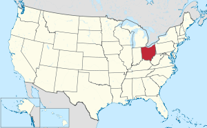 Map of the United States with Ohio highlighted | |
| Country | United States |
| Admitted to the Union | March 1, 1803[4] (17th, declared retroactively on August 7, 1953[5]) |
| Capital (and largest city) | Columbus[6][7] |
| Largest metro | Greater Cincinnati Greater Columbus (see footnotes)[8] |
| Government | |
| • Governor | Mike DeWine (R) |
| • Lieutenant Governor | Jon A. Husted (R) |
| Legislature | General Assembly |
| • Upper house | Senate |
| • Lower house | House of Representatives |
| U.S. senators | Sherrod Brown (D) Rob Portman (R) |
| U.S. House delegation | 12 Republicans 4 Democrats (list) |
| Area | |
| • Total | 44,825 sq mi (116,096 km2) |
| • Land | 40,948 sq mi (106,156 km2) |
| • Water | 3,877 sq mi (10,040 km2) 8.7% |
| Area rank | 34th |
| Dimensions | |
| • Length | 220 mi (355 km) |
| • Width | 220 mi (355 km) |
| Elevation | 850 ft (260 m) |
| Highest elevation | 1,549 ft (472 m) |
| Lowest elevation | 455 ft (139 m) |
| Population (2019) | |
| • Total | 11,689,100 |
| • Rank | 7th |
| • Density | 282/sq mi (109/km2) |
| • Density rank | 10th |
| • Median household income | $54,021[11] |
| • Income rank | 36th |
| Demonym(s) | Ohioan; Buckeye[12] (colloq.) |
| Language | |
| • Official language | De jure: None De facto: English |
| • Spoken language | English 93.3% Spanish 2.2% Other 4.5%[13] |
| Time zone | UTC−05:00 (Eastern) |
| • Summer (DST) | UTC−04:00 (EDT) |
| USPS abbreviation | OH[14] |
| ISO 3166 code | US-OH |
| Trad. abbreviation | O., Oh. |
| Latitude | 38°24′ N to 41°59′ N |
| Longitude | 80°31′ W to 84°49′ W |
| Website | ohio |
| Ohio state symbols | |
|---|---|
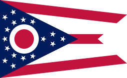 The Flag of Ohio | |
The Seal of Ohio | |
| Living insignia | |
| Amphibian | Spotted salamander |
| Bird | Cardinal (1933)[2] |
| Flower | Red carnation (1904)[2] |
| Insect | Ladybug (1975)[2] |
| Mammal | White-tailed deer (1987)[2] |
| Reptile | Black racer snake (1995)[2] |
| Tree | Buckeye (1953)[2] |
| Inanimate insignia | |
| Beverage | Tomato juice (1965)[2] |
| Fossil | Isotelus maximus, a trilobite (1985)[2] |
| Gemstone | Ohio flint (1965)[2] |
| Slogan | So Much to Discover |
| Other | Wild flower: Great white trillium (1986)[2] Fruit: Pawpaw |
| State route marker | |
 | |
| State quarter | |
 Released in 2002 | |
| Lists of United States state symbols | |
The state takes its name from the Ohio River, whose name in turn originated from the Seneca word ohiːyo', meaning "good river", "great river" or "large creek".[15][16][17] Partitioned from the Northwest Territory, Ohio was the 17th state admitted to the Union on March 1, 1803, and the first under the Northwest Ordinance.[4][18] Ohio is historically known as the "Buckeye State" after its Ohio buckeye trees, and Ohioans are also known as "Buckeyes".[12]
Ohio rose from the wilderness of Ohio Country west of Appalachia in colonial times through the Northwest Indian Wars as part of the Northwest Territory in the early frontier, to become the first non-colonial free state admitted to the union, to an industrial powerhouse in the 20th century before transitioning to a more information and service based economy in the 21st.
The government of Ohio is composed of the executive branch, led by the governor; the legislative branch, which comprises the bicameral Ohio General Assembly; and the judicial branch, led by the state Supreme Court. Ohio occupies 16 seats in the United States House of Representatives.[19] Ohio is known for its status as both a swing state and a bellwether in national elections.[20] Seven presidents of the United States have been elected who had Ohio as their home state.
Ohio is an industrial state, ranking 8th out of 50 states in GDP (2015), is the third largest US state for manufacturing,[21] and is the second largest producer of automobiles behind Michigan.
Geography
Ohio's geographic location has proven to be an asset for economic growth and expansion. Because Ohio links the Northeast to the Midwest, much cargo and business traffic passes through its borders along its well-developed highways. Ohio has the nation's 10th largest highway network and is within a one-day drive of 50% of North America's population and 70% of North America's manufacturing capacity.[22] To the north, Lake Erie gives Ohio 312 miles (502 km) of coastline,[23] which allows for numerous cargo ports. Ohio's southern border is defined by the Ohio River (with the border being at the 1792 low-water mark on the north side of the river),[24] and much of the northern border is defined by Lake Erie. Ohio's neighbors are Pennsylvania to the east, Michigan to the northwest, Lake Erie to the north, Indiana to the west, Kentucky on the south, and West Virginia on the southeast. Ohio's borders were defined by metes and bounds in the Enabling Act of 1802 as follows:
Bounded on the east by the Pennsylvania line, on the south by the Ohio River, to the mouth of the Great Miami River, on the west by the line drawn due north from the mouth of the Great Miami aforesaid, and on the north by an east and west line drawn through the southerly extreme of Lake Michigan, running east after intersecting the due north line aforesaid, from the mouth of the Great Miami until it shall intersect Lake Erie or the territorial line, and thence with the same through Lake Erie to the Pennsylvania line aforesaid.
Ohio is bounded by the Ohio River, but nearly all of the river itself belongs to Kentucky and West Virginia. In 1980, the U.S. Supreme Court held that, based on the wording of the cessation of territory by Virginia (which at the time included what is now Kentucky and West Virginia), the boundary between Ohio and Kentucky (and, by implication, West Virginia) is the northern low-water mark of the river as it existed in 1792.[24] Ohio has only that portion of the river between the river's 1792 low-water mark and the present high-water mark.
The border with Michigan has also changed, as a result of the Toledo War, to angle slightly northeast to the north shore of the mouth of the Maumee River.
Much of Ohio features glaciated till plains, with an exceptionally flat area in the northwest being known as the Great Black Swamp. This glaciated region in the northwest and central state is bordered to the east and southeast first by a belt known as the glaciated Allegheny Plateau, and then by another belt known as the unglaciated Allegheny Plateau. Most of Ohio is of low relief, but the unglaciated Allegheny Plateau features rugged hills and forests.

The rugged southeastern quadrant of Ohio, stretching in an outward bow-like arc along the Ohio River from the West Virginia Panhandle to the outskirts of Cincinnati, forms a distinct socio-economic unit. Geologically similar to parts of West Virginia and southwestern Pennsylvania, this area's coal mining legacy, dependence on small pockets of old manufacturing establishments, and distinctive regional dialect set this section off from the rest of the state. In 1965 the United States Congress passed the Appalachian Regional Development Act, an attempt to "address the persistent poverty and growing economic despair of the Appalachian Region".[25] This act defines 29 Ohio counties as part of Appalachia.[26] While 1/3 of Ohio's land mass is part of the federally defined Appalachian region, only 12.8% of Ohioans live there (1.476 million people.)[27]
Significant rivers within the state include the Cuyahoga River, Great Miami River, Maumee River, Muskingum River, and Scioto River. The rivers in the northern part of the state drain into the northern Atlantic Ocean via Lake Erie and the St. Lawrence River, and the rivers in the southern part of the state drain into the Gulf of Mexico via the Ohio River and then the Mississippi.
The worst weather disaster in Ohio history occurred along the Great Miami River in 1913. Known as the Great Dayton Flood, the entire Miami River watershed flooded, including the downtown business district of Dayton. As a result, the Miami Conservancy District was created as the first major flood plain engineering project in Ohio and the United States.[28]
Grand Lake St. Marys in the west-central part of the state was constructed as a supply of water for canals in the canal-building era of 1820–1850. For many years this body of water, over 20 square miles (52 km2), was the largest artificial lake in the world. Ohio's canal-building projects were not the economic fiasco that similar efforts were in other states. Some cities, such as Dayton, owe their industrial emergence to location on canals, and as late as 1910 interior canals carried much of the bulk freight of the state.
Climate
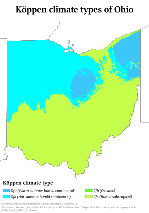
The climate of Ohio is a humid continental climate (Köppen climate classification Dfa/Dfb) throughout most of the state, except in the extreme southern counties of Ohio's Bluegrass region section, which are located on the northern periphery of the humid subtropical climate (Cfa) and Upland South region of the United States. Summers are typically hot and humid throughout the state, while winters generally range from cool to cold. Precipitation in Ohio is moderate year-round. Severe weather is not uncommon in the state, although there are typically fewer tornado reports in Ohio than in states located in what is known as the Tornado Alley. Severe lake effect snowstorms are also not uncommon on the southeast shore of Lake Erie, which is located in an area designated as the Snowbelt.
Although predominantly not in a subtropical climate, some warmer-climate flora and fauna do reach well into Ohio. For instance, some trees with more southern ranges, such as the blackjack oak, Quercus marilandica, are found at their northernmost in Ohio just north of the Ohio River. Also evidencing this climatic transition from a subtropical to continental climate, several plants such as the Southern magnolia (Magnolia grandiflora), Albizia julibrissin (mimosa), Crape Myrtle, and even the occasional needle palm are hardy landscape materials regularly used as street, yard, and garden plantings in the Bluegrass region of Ohio; but these same plants will simply not thrive in much of the rest of the state. This interesting change may be observed while traveling through Ohio on Interstate 75 from Cincinnati to Toledo; the observant traveler of this diverse state may even catch a glimpse of Cincinnati's common wall lizard, one of the few examples of permanent "subtropical" fauna in Ohio.
Due to flooding resulting in severely damaged highways, Governor Mike DeWine declared a state of emergency in 37 Ohio counties in 2019.[29]
| Location | Region | July (°F) | July (°C) | January (°F) | January (°C) |
|---|---|---|---|---|---|
| Athens | Appalachian | 85/61 | 29/16 | 40/21 | 4/−6 |
| Canton | Northeast | 82/62 | 28/16 | 33/19 | 1/−7 |
| Cincinnati | Southwest | 86/66 | 30/19 | 39/23 | 3/−5 |
| Cleveland | Northeast | 82/64 | 28/18 | 34/21 | 1/−5 |
| Columbus | Central | 85/65 | 29/18 | 36/22 | 2/−5 |
| Dayton | Miami Valley | 87/67 | 31/19 | 36/22 | 2/−5 |
| Toledo | Northwest | 84/62 | 29/17 | 32/18 | 0/−7 |
Records
The highest recorded temperature was 113 °F (45 °C), near Gallipolis on July 21, 1934.[31] The lowest recorded temperature was −39 °F (−39 °C), at Milligan on February 10, 1899,[32] during the Great Blizzard of 1899.[33]
Earthquakes
Although few have registered as noticeable to the average resident, more than 200 earthquakes with a magnitude of 2.0 or higher have occurred in Ohio since 1776.[34] The Western Ohio Seismic Zone and a portion of the Southern Great Lakes Seismic Zone are located in the state, and numerous faults lie under the surface.[34][35]
The most substantial known earthquake in Ohio history was the Anna (Shelby County) earthquake,[36] which occurred on March 9, 1937. It was centered in western Ohio, and had a magnitude of 5.4, and was of intensity VIII.[37]
Other significant earthquakes in Ohio include:[38] one of magnitude 4.8 near Lima on September 19, 1884;[39] one of magnitude 4.2 near Portsmouth on May 17, 1901;[40] and one of 5.0 in LeRoy Township in Lake County on January 31, 1986, which continued to trigger 13 aftershocks of magnitude 0.5 to 2.4 for two months.[41][42]
Notable Ohio earthquakes in the 21st century include one occurring on December 31, 2011, approximately 4 kilometers (2.5 mi) northwest of Youngstown,[43] and one occurring on June 10, 2019, approximately 5 kilometers (3.1 mi) north-northwest of Eastlake under Lake Erie;[44] both registered a 4.0 magnitude.
Major cities
Columbus is both the capital of Ohio and its largest city, located near the geographic center of the state and well known for The Ohio State University. However, other Ohio cities function as economic and cultural centers of metropolitan areas. Akron, Canton, Cleveland, Mansfield, and Youngstown are in the Northeast, known for major industrial companies Goodyear Tire and Rubber and Timken, top ranked colleges Case Western Reserve University and Kent State University, the Cleveland Clinic, and cultural attractions including the Cleveland Museum of Art, Big Five group Cleveland Orchestra, Playhouse Square, the Pro Football Hall of Fame, and the Rock and Roll Hall of Fame. Lima and Toledo are the major cities in Northwest Ohio. Northwest Ohio is known for its glass making industry, and is home to Owens Corning and Owens-Illinois, two Fortune 500 corporations. Dayton and Springfield are located in the Miami Valley, which is home to the University of Dayton, the Dayton Ballet, and the extensive Wright-Patterson Air Force Base. Cincinnati anchors Southwest Ohio, home of Miami University and the University of Cincinnati, Cincinnati Union Terminal, Cincinnati Symphony Orchestra, and various Fortune 500 companies including Procter & Gamble, Kroger, Macy's, Inc., and Fifth Third Bank. Steubenville is the only metropolitan city in Appalachian Ohio, which is home to Hocking Hills State Park.
Metropolitan and micropolitan areas
| Ohio Rank | U.S. Rank | Metropolitan statistical area[46] | 2018 Estimate[47] | 2010 Census[47] | Change | Counties[46] |
|---|---|---|---|---|---|---|
| 1 | 28 | Cincinnati, OH-KY-IN Metropolitan Statistical Area | 2,190,209 | 2,179,082 | +0.51% | Brown, Butler, Clermont, Clinton, Hamilton, Warren |
| 2 | 32 | Columbus, OH Metropolitan Statistical Area | 2,106,541 | 2,078,725 | +1.34% | Delaware, Fairfield, Franklin, Hocking, Licking, Madison, Morrow, Perry, Pickaway, Union |
| 3 | 33 | Cleveland-Elyria, OH Metropolitan Statistical Area | 2,057,009 | 2,058,844 | −0.09% | Cuyahoga, Geauga, Lake, Lorain, Medina |
| 4 | 73 | Dayton, OH Metropolitan Statistical Area | 806,548 | 799,232 | +0.92% | Greene, Miami, Montgomery |
| 5 | 82 | Akron, OH Metropolitan Statistical Area | 704,845 | 703,200 | +0.23% | Portage, Summit |
| Ohio Rank | U.S. Rank | Combined statistical areas[48] | 2018 Estimate[49] | 2010 Census[49] | Change | Subdivisions |
|---|---|---|---|---|---|---|
| 1 | 16 | Cleveland-Akron-Canton, OH Combined Statistical Area | 3,483,297 | 3,515,646 | −0.92% | Cleveland-Elyria, OH Metropolitan Statistical Area Akron, OH Metropolitan Statistical Area Canton-Massillon, OH Metropolitan Statistical Area Ashtabula, OH Micropolitan Statistical Area New Philadelphia-Dover, OH Micropolitan Statistical Area Sandusky, OH Micropolitan Statistical Area Norwalk, OH Micropolitan Statistical Area |
| 2 | 24 | Columbus-Marion-Zanesville, OH Combined Statistical Area | 2,509,850 | 2,308,509 | +8.72% | Columbus, OH Metropolitan Statistical Area Zanesville, OH Micropolitan Statistical Area Chillicothe, OH Micropolitan Statistical Area Marion, OH Micropolitan Statistical Area Mount Vernon, OH Micropolitan Statistical Area Bellefontaine, OH Micropolitan Statistical Area Cambridge, OH Micropolitan Statistical Area Washington Court House, OH Micropolitan Statistical Area |
| 3 | 28 | Cincinnati-Wilmington-Maysville, OH-KY-IN Combined Statistical Area | 2,249,416 | 2,174,110 | +3.46% | Cincinnati, OH-KY-IN Metropolitan Statistical Area Wilmington, OH Micropolitan Statistical Area Maysville, KY Micropolitan Statistical Area |
| 4 | 52 | Dayton-Springfield-Sidney, OH Combined Statistical Area | 1,079,837 | 1,080,044 | −0.02% | Dayton, OH Metropolitan Statistical Area Springfield, OH Metropolitan Statistical Area Greenville, OH Micropolitan Statistical Area Sidney, OH Micropolitan Statistical Area Urbana, OH Micropolitan Statistical Area |
| 5 | 74 | Youngstown-Warren, OH-PA Combined Statistical Area | 641,617 | 673,614 | −4.75% | Youngstown-Warren-Boardman, OH-PA Metropolitan Statistical Area Salem, OH Micropolitan Statistical Area |
The Cincinnati metropolitan area extends into Kentucky and Indiana, the Steubenville metropolitan area extends into West Virginia, the Toledo metropolitan area extends into Michigan, and the Youngstown metropolitan area extends into Pennsylvania.
Ohio cities that function as centers of United States micropolitan areas include:
- Ashland (home of Ashland University)
- Ashtabula
- Athens (home of Ohio University)
- Bellefontaine
- Bucyrus
- Cambridge
- Celina
- Chillicothe
- Coshocton
- Defiance (home of Defiance College)
- Findlay (home of The University of Findlay)
- Fremont
- Greenville
- Marion (home of Marion Popcorn Festival)
- Mount Vernon (home of Mount Vernon Nazarene University)
- New Philadelphia-Dover
- Norwalk (home of Summit Motorsports Park, headquarters of the International Hot Rod Association, and pioneer automobile company Fisher Body)
- Oxford (home of Miami University)
- Portsmouth (home of Shawnee State University)
- Salem
- Sandusky (home of Cedar Point, and Kalahari Resort and Convention Center)
- Sidney
- Tiffin (home of Heidelberg College and Tiffin University)
- Urbana (home of Urbana University)
- Van Wert
- Wapakoneta (birthplace of Apollo 11 astronaut Neil Armstrong)
- Washington Court House
- Wilmington (home of Wilmington College)
- Wooster (home of The College of Wooster)
- Zanesville (home of Zane State College)
History
Native Americans
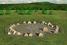
Archeological evidence of spear points of both the Folsom and Clovis types indicate that the Ohio Valley was inhabited by nomadic people as early as 13,000 BC.[50] These early nomads disappeared from Ohio by 1,000 BC.[50] Between 1,000 and 800 BC, the sedentary Adena culture emerged. The Adena were able to establish "semi-permanent" villages because they domesticated plants, including, sunflowers, and "grew squash and possibly corn"; with hunting and gathering, this cultivation supported more settled, complex villages.[51] The most notable remnant of the Adena culture is the Great Serpent Mound, located in Adams County, Ohio.[51]
Around 100 BC, the Adena evolved into the Hopewell people who were also mound builders. Their complex, large and technologically sophisticated earthworks can be found in modern-day Marietta, Newark, and Circleville.[52] They were also a prolific trading society, their trading network spanning a third of the continent.[53] The Hopewell disappeared from the Ohio Valley about 600 AD. The Mississippian Culture rose as the Hopewell Culture declined. Many Siouan-speaking peoples from the plains and east coast claim them as ancestors and say they lived throughout the Ohio region until approximately the 13th century.[54]
There were three other cultures contemporaneous with the Mississippians: the Fort Ancient people, the Whittlesey Focus people[54] and the Monongahela Culture.[55] All three cultures disappeared in the 17th century. Their origins are unknown. The Shawnees may have absorbed the Fort Ancient people.[54] It is also possible that the Monongahela held no land in Ohio during the Colonial Era. The Mississippian Culture were close to and traded extensively with the Fort Ancient people.
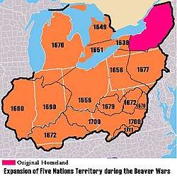
Indians in the Ohio Valley were greatly affected by the aggressive tactics of the Iroquois Confederation, based in central and western New York.[56] After the Beaver Wars in the mid-17th century, the Iroquois claimed much of the Ohio country as hunting and, more importantly, beaver-trapping ground. After the devastation of epidemics and war in the mid-17th century, which largely emptied the Ohio country of indigenous people by the mid-to-late 17th century, the land gradually became repopulated by the mostly Algonquian. Many of these Ohio-country nations were multi-ethnic (sometimes multi-linguistic) societies born out of the earlier devastation brought about by disease, war, and subsequent social instability. They subsisted on agriculture (corn, sunflowers, beans, etc.) supplemented by seasonal hunts. By the 18th century, they were part of a larger global economy brought about by European entry into the fur trade.[57]
The indigenous nations to inhabit Ohio in the historical period included the Iroquoian,[58] the Algonquian[59] & the Siouan.[60][61][62] Ohio country was also the site of Indian massacres, such as the Yellow Creek Massacre, Gnadenhutten and Pontiac's Rebellion school massacre.[63] Most Native Peoples who remained in Ohio were slowly bought out and convinced to leave, or ordered to do so by law, in the early 19th century with the Indian Removal Act of 1830.
Colonial and Revolutionary eras
During the 18th century, the French set up a system of trading posts to control the fur trade in the region. Beginning in 1754, France and Great Britain fought the French and Indian War. As a result of the Treaty of Paris, the French ceded control of Ohio and the remainder of the Old Northwest to Great Britain.
Pontiac's Rebellion in the 1760s, however, posed a challenge to British military control.[64] This came to an end with the colonists' victory in the American Revolution. In the Treaty of Paris in 1783, Britain ceded all claims to Ohio country to the United States.
Northwest Territory
The United States created the Northwest Territory under the Northwest Ordinance of 1787.[65] Slavery was not permitted in the new territory. Settlement began with the founding of Marietta by the Ohio Company of Associates, which had been formed by a group of American Revolutionary War veterans. Following the Ohio Company, the Miami Company (also referred to as the "Symmes Purchase") claimed the southwestern section, and the Connecticut Land Company surveyed and settled the Connecticut Western Reserve in present-day Northeast Ohio. Territorial surveyors from Fort Steuben began surveying an area of eastern Ohio called the Seven Ranges at about the same time.
The old Northwest Territory originally included areas previously known as Ohio Country and Illinois Country. As Ohio prepared for statehood, the Indiana Territory was created, reducing the Northwest Territory to approximately the size of present-day Ohio plus the eastern half of the Lower Peninsula of Michigan and the eastern tip of the Upper Peninsula and a sliver of southeastern Indiana called "The Gore".
Under the Northwest Ordinance, areas could be defined and admitted as states once their population reached 60,000. Although Ohio's population was only 45,000 in December 1801, Congress determined that it was growing rapidly and had already begun the path to statehood. In regards to the Leni Lenape natives, Congress decided that 10,000 acres on the Muskingum River in the present state of Ohio would "be set apart and the property thereof be vested in the Moravian Brethren ... or a society of the said Brethren for civilizing the Indians and promoting Christianity".[66]
Statehood and settlement
On February 19, 1803, U.S. president Thomas Jefferson signed an act of Congress that approved Ohio's boundaries and constitution.[67] However, Congress had never passed a resolution formally admitting Ohio as the 17th state. The current custom of Congress declaring an official date of statehood did not begin until 1812, with Louisiana's admission as the 18th state. Although no formal resolution of admission was required, when the oversight was discovered in 1953, Ohio congressman George H. Bender introduced a bill in Congress to admit Ohio to the Union retroactive to March 1, 1803, the date on which the Ohio General Assembly first convened.[68] At a special session at the old state capital in Chillicothe, the Ohio state legislature approved a new petition for statehood which was delivered to Washington, D.C., on horseback. On August 7, 1953 (the year of Ohio's 150th anniversary), President Eisenhower signed a congressional joint resolution that officially declared March 1, 1803, the date of Ohio's admittance into the Union.[68][69][70]
Ohio has had three capital cities: Chillicothe, Zanesville, and Columbus. Chillicothe was the capital from 1803 to 1810. The capital was then moved to Zanesville for two years, as part of a state legislative compromise to get a bill passed. The capital was then moved back to Chillicothe, which was the capital from 1812 to 1816. Finally, the capital was moved to Columbus, to have it near the geographic center of the state.
Although many Native Americans had migrated west to evade American encroachment, others remained settled in the state, sometimes assimilating in part. In 1830 under President Andrew Jackson, the US government forced Indian Removal of most tribes to the Indian Territory west of the Mississippi River.
In 1835, Ohio fought with Michigan in the Toledo War, a mostly bloodless boundary war over the Toledo Strip. Only one person was injured in the conflict. Congress intervened, making Michigan's admittance as a state conditional on ending the conflict. In exchange for giving up its claim to the Toledo Strip, Michigan was given the western two-thirds of the Upper Peninsula, in addition to the eastern third which was already considered part of the state.
Civil War and growth
Ohio's central position and its population gave it an important place during the Civil War. The Ohio River was a vital artery for troop and supply movements, as were Ohio's railroads. The industry of Ohio made the state one of the most important states in the Union during the Civil war. Ohio contributed more soldiers per-capita than any other state in the Union. In 1862, the state's morale was badly shaken in the aftermath of the Battle of Shiloh, a costly victory in which Ohio forces suffered 2,000 casualties.[71] Later that year, when Confederate troops under the leadership of Stonewall Jackson threatened Washington, D.C., Ohio governor David Tod still could recruit 5,000 volunteers to provide three months of service.[72] From July 12 to July 23, 1863, Southern Ohio and Indiana were attacked in Morgan's Raid. While this raid was insignificant and small, it aroused fear among people in Ohio and Indiana.[73] Almost 35,000 Ohioans died in the conflict, and 30,000 were physically wounded.[74] By the end of the Civil War, the Union's top three generals–Ulysses S. Grant, William Tecumseh Sherman, and Philip Sheridan–were all from Ohio.[75][76]
Industrialization
In 1912 a Constitutional Convention was held with Charles Burleigh Galbreath as secretary. The result reflected the concerns of the Progressive Era. It introduced the initiative and the referendum. Also, it allowed the General Assembly to put questions on the ballot for the people to ratify laws and constitutional amendments originating in the Legislature. Under the Jeffersonian principle that laws should be reviewed once a generation, the constitution provided for a recurring question to appear on Ohio's general election ballots every 20 years. The question asks whether a new convention is required. Although the question has appeared in 1932, 1952, 1972, and 1992, it has never been approved. Instead, constitutional amendments have been proposed by petition to the legislature hundreds of times and adopted in a majority of cases.
Demographics
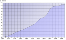
| Historical population | |||
|---|---|---|---|
| Census | Pop. | %± | |
| 1800 | 45,365 | — | |
| 1810 | 230,760 | 408.7% | |
| 1820 | 581,434 | 152.0% | |
| 1830 | 937,903 | 61.3% | |
| 1840 | 1,519,467 | 62.0% | |
| 1850 | 1,980,329 | 30.3% | |
| 1860 | 2,339,511 | 18.1% | |
| 1870 | 2,665,260 | 13.9% | |
| 1880 | 3,198,062 | 20.0% | |
| 1890 | 3,672,329 | 14.8% | |
| 1900 | 4,157,545 | 13.2% | |
| 1910 | 4,767,121 | 14.7% | |
| 1920 | 5,759,394 | 20.8% | |
| 1930 | 6,646,697 | 15.4% | |
| 1940 | 6,907,612 | 3.9% | |
| 1950 | 7,946,627 | 15.0% | |
| 1960 | 9,706,397 | 22.1% | |
| 1970 | 10,652,017 | 9.7% | |
| 1980 | 10,797,630 | 1.4% | |
| 1990 | 10,847,115 | 0.5% | |
| 2000 | 11,353,140 | 4.7% | |
| 2010 | 11,536,504 | 1.6% | |
| Est. 2019 | 11,689,100 | 1.3% | |
| Source: 1910–2010[77] 2019 Estimate[78] | |||
Population
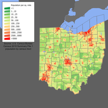
From just over 45,000 residents in 1800, Ohio's population grew faster than 10% per decade (except for the 1940 census) until the 1970 census, which recorded just over 10.65 million Ohioans.[79] Growth then slowed for the next four decades.[80] The United States Census Bureau estimates that the population of Ohio was 11,689,100 on July 1, 2019, a 1.32% increase since the 2010 United States Census.[78] Ohio's population growth lags that of the entire United States, and Caucasians are found in a greater density than the United States average. As of 2000, Ohio's center of population is located in Morrow County,[81] in the county seat of Mount Gilead.[82] This is approximately 6,346 feet (1,934 m) south and west of Ohio's population center in 1990.[81]
As of 2011, 27.6% of Ohio's children under the age of 1 belonged to minority groups.[83]
6.2% of Ohio's population is under five years of age, 23.7 percent under 18 years of age, and 14.1 percent were 65 or older. Females made up approximately 51.2 percent of the population.
Birth data
Note: Births in table don't add up, because Hispanics are counted both by their ethnicity and by their race, giving a higher overall number.
| Race | 2013[84] | 2014[85] | 2015[86] | 2016[87] | 2017[88] | 2018[89] |
|---|---|---|---|---|---|---|
| White | 109,749 (79.0%) | 110,003 (78.9%) | 109,566 (78.7%) | ... | ... | ... |
| > Non-Hispanic White | 104,059 (74.9%) | 104,102 (74.6%) | 103,586 (74.4%) | 100,225 (72.6%) | 98,762 (72.1%) | 97,423 (72.1%) |
| Black | 24,952 (18.0%) | 24,931 (17.9%) | 25,078 (18.0%) | 22,337 (16.2%) | 22,431 (16.4%) | 22,201 (16.4%) |
| Asian | 3,915 (2.8%) | 4,232 (3.0%) | 4,367 (3.1%) | 4,311 (3.1%) | 4,380 (3.2%) | 4,285 (3.2%) |
| American Indian | 320 (0.2%) | 301 (0.2%) | 253 (0.2%) | 128 (0.1%) | 177 (0.1%) | 169 (0.1%) |
| Hispanic (of any race) | 6,504 (4.7%) | 6,884 (4.9%) | 6,974 (5.0%) | 7,420 (5.4%) | 7,468 (5.5%) | 7,432 (5.5%) |
| Total Ohio | 138,936 (100%) | 139,467 (100%) | 139,264 (100%) | 138,085 (100%) | 136,832 (100%) | 135,134 (100%) |
- Since 2016, data for births of White Hispanic origin are not collected, but included in one Hispanic group; persons of Hispanic origin may be of any race.
Ancestry
According to the 2010 United States Census, the racial composition of Ohio was the following:[90][91]
- White American: 82.7% (Non-Hispanic Whites: 81.1%)
- Black or African American: 12.2%
- Native American: 0.2%
- Asian: 1.7% (0.6% Indian, 0.4% Chinese, 0.1% Filipino, 0.1% Korean, 0.1% Vietnamese, 0.1% Japanese)
- Pacific Islander: 0.03%
- Two or more races: 2.1%
- Some other race: 1.1%
- Hispanic or Latinos (of any race) make up 3.1% (1.5% Mexican, 0.8% Puerto Rican, 0.1% Guatemalan, 0.1% Cuban)
| Racial composition | 1990[92] | 2000[93] | 2010[94] |
|---|---|---|---|
| White | 87.8% | 85.0% | 82.7% |
| African American | 10.6% | 11.5% | 12.2% |
| Asian | 0.8% | 1.2% | 1.7% |
| Native | 0.2% | 0.2% | 0.2% |
| Native Hawaiian and other Pacific Islander | – | – | – |
| Other race | 0.5% | 0.8% | 1.1% |
| Two or more races | – | 1.4% | 2.1% |
In 2010, there were 469,700 foreign-born residents in Ohio, corresponding to 4.1% of the total population. Of these, 229,049 (2.0%) were naturalized US citizens and 240,699 (2.1%) were not.[13] The largest groups were:[95] Mexico (54,166), India (50,256), China (34,901), Germany (19,219), Philippines (16,410), United Kingdom (15,917), Canada (14,223), Russia (11,763), South Korea (11,307), and Ukraine (10,681). Though predominantly white, Ohio has large black populations in all major metropolitan areas throughout the state, Ohio has a significant Hispanic population made up of Mexicans in Toledo and Columbus, and Puerto Ricans in Cleveland and Columbus, and also has a significant and diverse Asian population in Columbus.
The largest ancestry groups (which the Census defines as not including racial terms) in the state are:[13][96]
- 26.5% German
- 14.1% Irish
- 9.0% English
- 6.4% Italian
- 3.8% Polish
- 2.5% French
- 1.9% Scottish
- 1.7% Hungarian
- 1.6% Dutch
- 1.5% Mexican
- 1.2% Slovak
- 1.1% Welsh
- 1.1% Scotch-Irish
Ancestries claimed by less than 1% of the population include Sub-Saharan African, Puerto Rican, Swiss, Swedish, Arab, Greek, Norwegian, Romanian, Austrian, Lithuanian, Finnish, West Indian, Portuguese and Slovene.
Languages
About 6.7% of the population age 5 years and older reported speaking a language other than English, with 2.2% of the population speaking Spanish, 2.6% speaking other Indo-European languages, 1.1% speaking Asian and Austronesian languages, and 0.8% speaking other languages.[13] Numerically: 10,100,586 spoke English, 239,229 Spanish, 55,970 German, 38,990 Chinese, 33,125 Arabic, and 32,019 French. In addition 59,881 spoke a Slavic language and 42,673 spoke another West Germanic language according to the 2010 Census.[97] Ohio also had the nation's largest population of Slovene speakers, second largest of Slovak speakers, second largest of Pennsylvania Dutch (German) speakers, and the third largest of Serbian speakers.[98]
Religion
According to a Pew Forum poll, as of 2008, 76% of Ohioans identified as Christian.[99] Specifically, 26% of Ohio's population identified as Evangelical Protestant, 22% as Mainline Protestant, and 21% as Catholic.[99] 17% of the population is unaffiliated with any religious body.[99] 1.3% (148,380) were Jewish.[100] There are also small minorities of Jehovah's Witnesses (1%), Muslims (1%), Hindus (<0.5%), Buddhists (<0.5%), Mormons (<0.5%), and other faiths (1-1.5%).[99]
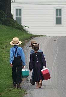
According to the Association of Religion Data Archives (ARDA), in 2010 the largest denominations by adherents were the Catholic Church with 1,992,567; the United Methodist Church with 496,232; the Evangelical Lutheran Church in America with 223,253, the Southern Baptist Convention with 171,000, the Christian Churches and Churches of Christ with 141,311, the United Church of Christ with 118,000, and the Presbyterian Church (USA) with 110,000.[101] With about 70,000 people in 2015 Ohio had the second largest Amish population of all states of the US.[102]
According to the same data, a majority of Ohioans, 55%, feel religion is "very important", 30% that it is "somewhat important", and 15% that religion is "not too important/not important at all".[99] 36% of Ohioans indicate that they attend religious services at least once weekly, 35% occasionally, and 27% seldom or never.[99]
Economy

According to the U.S. Census Bureau, the total number for employment in 2016 was 4,790,178. The total number of unique employer establishments was 252,201, while the total number of nonemployer establishments was 785,833.[104] In 2010, Ohio was ranked second in the country for best business climate by Site Selection magazine, based on a business-activity database.[105] The state has also won three consecutive Governor's Cup awards from the magazine, based on business growth and developments.[106] As of 2016, Ohio's gross domestic product (GDP) was $626 billion.[107] This ranks Ohio's economy as the seventh-largest of all fifty states and the District of Columbia.[108]
The Small Business & Entrepreneurship Council ranked the state No. 10 for best business-friendly tax systems in their Business Tax Index 2009, including a top corporate tax and capital gains rate that were both ranked No. 6 at 1.9%.[109] Ohio was ranked No. 11 by the council for best friendly-policy states according to their Small Business Survival Index 2009.[110] The Directorship's Boardroom Guide ranked the state No. 13 overall for best business climate, including No. 7 for best litigation climate.[111] Forbes ranked the state No. 8 for best regulatory environment in 2009.[112] Ohio has five of the top 115 colleges in the nation, according to U.S. News and World Report's 2010 rankings,[113] and was ranked No. 8 by the same magazine in 2008 for best high schools.[114]
Ohio's unemployment rate stands at 4.5% as of February 2018,[115] down from 10.7% in May 2010.[116][117] The state still lacks 45,000 jobs compared to the pre-recession numbers of 2007.[118] The labor force participation as of April 2015 is 63%, slightly above the national average.[118] Ohio's per capita income stands at $34,874.[108][119] As of 2016, Ohio's median household income is $52,334,[120] and 14.6% of the population is below the poverty line[121]
The manufacturing and financial activities sectors each compose 18.3% of Ohio's GDP, making them Ohio's largest industries by percentage of GDP.[108] Ohio has the third largest manufacturing workforce behind California and Texas.[122][123] Ohio has the largest bioscience sector in the Midwest, and is a national leader in the "green" economy. Ohio is the largest producer in the country of plastics, rubber, fabricated metals, electrical equipment, and appliances.[124] 5,212,000 Ohioans are currently employed by wage or salary.[108]
By employment, Ohio's largest sector is trade/transportation/utilities, which employs 1,010,000 Ohioans, or 19.4% of Ohio's workforce, while the health care and education sector employs 825,000 Ohioans (15.8%).[108] Government employs 787,000 Ohioans (15.1%), manufacturing employs 669,000 Ohioans (12.9%), and professional and technical services employs 638,000 Ohioans (12.2%).[108] Ohio's manufacturing sector is the third-largest of all fifty United States states in terms of gross domestic product.[108] Fifty-nine of the United States' top 1,000 publicly traded companies (by revenue in 2008) are headquartered in Ohio, including Procter & Gamble, Goodyear Tire & Rubber, AK Steel, Timken, Abercrombie & Fitch, and Wendy's.[125]
Ohio is also one of 41 states with its own lottery,[126] the Ohio Lottery.[127] The Ohio Lottery has contributed over $15.5 billion to public education in its 34-year history.[128]
Transportation
Ground travel
Many major east–west transportation corridors go through Ohio. One of those pioneer routes, known in the early 20th century as "Main Market Route 3", was chosen in 1913 to become part of the historic Lincoln Highway which was the first road across America, connecting New York City to San Francisco. In Ohio, the Lincoln Highway linked many towns and cities together, including Canton, Mansfield, Wooster, Lima, and Van Wert. The arrival of the Lincoln Highway to Ohio was a major influence on the development of the state. Upon the advent of the federal numbered highway system in 1926, the Lincoln Highway through Ohio became U.S. Route 30.
Ohio also is home to 228 miles (367 km) of the Historic National Road, now U.S. Route 40.
Ohio has a highly developed network of roads and interstate highways. Major east-west through routes include the Ohio Turnpike (I-80/I-90) in the north, I-76 through Akron to Pennsylvania, I-70 through Columbus and Dayton, and the Appalachian Highway (State Route 32) running from West Virginia to Cincinnati. Major north–south routes include I-75 in the west through Toledo, Dayton, and Cincinnati, I-71 through the middle of the state from Cleveland through Columbus and Cincinnati into Kentucky, and I-77 in the eastern part of the state from Cleveland through Akron, Canton, New Philadelphia and Marietta south into West Virginia. Interstate 75 between Cincinnati and Dayton is one of the heaviest traveled sections of interstate in Ohio.
Ohio also has a highly developed network of signed state bicycle routes. Many of them follow rail trails, with conversion ongoing. The Ohio to Erie Trail (route 1) connects Cincinnati, Columbus, and Cleveland. U.S. Bicycle Route 50 traverses Ohio from Steubenville to the Indiana state line outside Richmond.[129]
Ohio has several long-distance hiking trails, the most prominent of which is the Buckeye Trail which extends 1,444 mi (2,324 km) in a loop around the state of Ohio. Part of it is on roads and part is on wooded trail. Additionally, the North Country Trail (the longest of the eleven National Scenic Trails authorized by Congress) and the American Discovery Trail (a system of recreational trails and roads that collectively form a coast-to-coast route across the mid-tier of the United States) pass through Ohio. Much of these two trails coincide with the Buckeye Trail.
Air travel
Ohio has five international airports, four commercial, and two military. The five international include Cleveland Hopkins International Airport, John Glenn Columbus International Airport, and Dayton International Airport, Ohio's third largest airport. Akron Fulton International Airport handles cargo and for private use. Rickenbacker International Airport is one of two military airfields which is also home to the 7th largest FedEx building in America. The other military airfield is Wright Patterson Air Force Base which is one of the largest Air Force bases in the United States. Other major airports are located in Toledo and Akron.
Cincinnati/Northern Kentucky International Airport is in Hebron, Kentucky, and therefore is not listed above.
Transportation lists
- List of Ohio state highways
- List of Ohio train stations
- List of Ohio railroads
- List of Ohio rivers
- Historic Ohio Canals
Law and government

The state government of Ohio consists of the executive, judicial, and legislative branches.[130][131][132]
Executive branch
The executive branch is headed by the governor of Ohio.[130] The current governor is Mike DeWine since 2019, a member of the Republican Party.[133] A lieutenant governor succeeds the governor in the event of any removal from office, and performs any duties assigned by the governor.[134][135] The current lieutenant governor is Jon A. Husted. The other elected constitutional offices in the executive branch are the secretary of state (Frank LaRose), auditor (Keith Faber), treasurer (Robert Sprague), and attorney general (Dave Yost).[130]
Judicial branch
There are three levels of the Ohio state judiciary. The lowest level is the court of common pleas: each county maintains its own constitutionally mandated court of common pleas, which maintain jurisdiction over "all justiciable matters".[136] The intermediate-level court system is the district court system.[137] Twelve courts of appeals exist, each retaining jurisdiction over appeals from common pleas, municipal, and county courts in a set geographical area.[136] A case heard in this system is decided by a three-judge panel, and each judge is elected.[136]
The highest-ranking court, the Ohio Supreme Court, is Ohio's "court of last resort".[138] A seven-justice panel composes the court, which, by its own discretion, hears appeals from the courts of appeals, and retains original jurisdiction over limited matters.[139]
Legislative branch
The Ohio General Assembly is a bicameral legislature consisting of the Senate and House of Representatives.[140] The Senate is composed of 33 districts, each of which is represented by one senator. Each senator represents approximately 330,000 constituents.[141] The House of Representatives is composed of 99 members.[142]
Politics

"Mother of presidents"
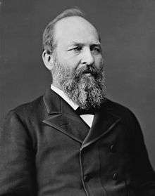
Eight US presidents hailed from Ohio at the time of their elections, giving rise to its nickname "mother of presidents", a sobriquet it shares with Virginia. It is also termed "modern mother of presidents",[143] in contrast to Virginia's status as the origin of presidents earlier in American history. Seven presidents were born in Ohio, making it second to Virginia's eight. Virginia-born William Henry Harrison lived most of his life in Ohio and is also buried there. Harrison conducted his political career while living on the family compound, founded by his father-in-law, John Cleves Symmes, in North Bend, Ohio. The seven presidents born in Ohio were Ulysses S. Grant, Rutherford B. Hayes, James A. Garfield, Benjamin Harrison (grandson of William Henry Harrison), William McKinley, William Howard Taft and Warren G. Harding.[144] All seven were Republicans.
Swing state
Ohio is considered a swing state, being won by either the Democratic or Republican candidates reasonably each election. As a swing state, Ohio is usually targeted by both major-party campaigns, especially in competitive elections.[145] Pivotal in the election of 1888, Ohio has been a regular swing state since 1980.[146][147]
Additionally, Ohio is considered a bellwether. Historian R. Douglas Hurt asserts that not since Virginia "had a state made such a mark on national political affairs".[148] The Economist notes that "This slice of the mid-west contains a bit of everything American—part north-eastern and part southern, part urban and part rural, part hardscrabble poverty and part booming suburb",[149] Since 1896, Ohio has had only two misses in the general election (Thomas E. Dewey in 1944 and Richard Nixon in 1960) and has the longest perfect streak of any state, voting for the winning presidential candidate in each election since 1964, and in 33 of the 37 held since the Civil War. No Republican has ever won the presidency without winning Ohio.
As of 2019, there are more than 7.8 million registered Ohioan voters, with 1.3 million Democrats and 1.9 million Republicans. They are disproportionate in age, with a million more over 65 than there are 18- to 24-year-olds.[150] Since the 2010 midterm elections, Ohio's voter demographic has leaned towards the Republican Party.[151] The governor, Mike DeWine, is Republican, as well as all other non-judicial statewide elected officials, including Lieutenant Governor Jon A. Husted, Attorney General Dave Yost, State Auditor Keith Faber, Secretary of State Frank LaRose and State Treasurer Robert Sprague. In the Ohio State Senate the Republicans are the majority, 24–9, and in the Ohio House of Representatives the Republicans control the delegation 61–38.
Losing two seats in the U.S. House of Representatives following the 2010 Census, Ohio has had 16 seats for the three presidential elections of the decade in 2012, 2016 and 2020.[152] As of the 2018 midterms, twelve federal representatives are Republicans while four are Democrats. Marcy Kaptur (D-09) is the most senior member of the Ohio delegation to the U.S. House of Representatives.[153] The senior U.S. senator, Sherrod Brown, is a Democrat, while the junior, Rob Portman, is a Republican.[154][155]
Voter suppression
Since 1994, the state has had a policy of purging infrequent voters from its rolls. In April 2016, a lawsuit was filed, challenging this policy on the grounds that it violated the National Voter Registration Act (NVRA) of 1993[156] and the Help America Vote Act of 2002.[157] In June, the federal district court ruled for the plaintiffs and entered a preliminary injunction applicable only to the November 2016 election. The preliminary injunction was upheld in September by the Court of Appeals for the Sixth Circuit. Had it not been upheld, thousands of voters would have been purged from the rolls just a few weeks before the election.[156]
Still, it has been estimated that the state has removed up to two million voters since 2011.[158]
Education
Ohio's system of public education is outlined in Article VI of the state constitution, and in Title XXXIII of the Ohio Revised Code. Ohio University, the first university in the Northwest Territory, was also the first public institution in Ohio. Substantively, Ohio's system is similar to those found in other states. At the State level, the Ohio Department of Education, which is overseen by the Ohio State Board of Education, governs primary and secondary educational institutions. At the municipal level, there are approximately 700 school districts statewide. The Ohio Board of Regents coordinates and assists with Ohio's institutions of higher education which have recently been reorganized into the University System of Ohio under Governor Strickland. The system averages an annual enrollment of more than 400,000 students, making it one of the five largest state university systems in the U.S.
.png)
Colleges and universities
Ohio schools consistently ranking in the top 50 nationally of the U.S. News & World Report of liberal arts colleges are Kenyon College, Oberlin College, and Denison University. Ranking in the top 100 nationally of the U.S. News & World Report of national research universities are Case Western Reserve University, Ohio State University and Miami University.[159]
- 13 state universities
- Bowling Green State University (Bowling Green)
- Central State University (Wilberforce)
- Cleveland State University (Cleveland)
- Kent State University (Kent)
- Miami University (Oxford)
- The Ohio State University (Columbus)
- Ohio University (Athens)
- Shawnee State University (Portsmouth)
- University of Akron (Akron)
- University of Cincinnati (Cincinnati)
- University of Toledo (Toledo)
- Wright State University (Dayton/Fairborn)
- Youngstown State University (Youngstown)
- 24 state university branch and regional campuses
- 46 private colleges and universities
- 6 free-standing state-assisted medical schools
- Boonshoft School of Medicine (formerly known as The Wright State University School of Medicine)
- Heritage College of Osteopathic Medicine, Ohio University
- Northeast Ohio Medical University
- The Ohio State University College of Medicine and Public Health
- University of Cincinnati College of Medicine
- University of Toledo College of Medicine (formerly Medical University of Ohio)
- 15 community colleges
- 8 technical colleges
- 24 independent non-profit colleges
Libraries
Ohio is home to some of the nation's highest-ranked public libraries.[160] The 2008 study by Thomas J. Hennen Jr. ranked Ohio as number one in a state-by-state comparison.[161] For 2008, 31 of Ohio's library systems were all ranked in the top ten for American cities of their population category.[160]
- 500,000 books or more
- Columbus Metropolitan Library (First)
- Cuyahoga County Public Library (Second)
- Public Library of Cincinnati and Hamilton County (Tenth)
The Ohio Public Library Information Network (OPLIN) is an organization that provides Ohio residents with internet access to their 251 public libraries. OPLIN also provides Ohioans with free home access to high-quality, subscription research databases.
Ohio also offers the OhioLINK program, allowing Ohio's libraries (particularly those from colleges and universities) access to materials for the other libraries. The program is largely successful in allowing researchers for access to books and other media that might not be otherwise available.
Culture
Arts
Sports
Professional sports teams
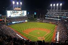
Ohio is home to nine professional sports teams in each of the five different major leagues in the United States. Current teams include the Cincinnati Reds and Cleveland Indians of Major League Baseball,[162][163] the Columbus Crew SC and FC Cincinnati of Major League Soccer,[164] the Cleveland Cavaliers of the National Basketball Association,[165] the Cincinnati Bengals and Cleveland Browns of the National Football League,[166] and the Columbus Blue Jackets of the National Hockey League.[167]
Ohio has brought home seven World Series titles (Reds 1919, 1940, 1975, 1976, 1990; Indians 1920, 1948), one MLS Cup (Crew 2008), one NBA Championship (Cavaliers 2016), and nine NFL Championships (Pros 1920; Bulldogs 1922, 1923, 1924; Rams 1945; Browns 1950, 1954, 1955, 1964). Despite this success in the NFL in the first half of the 20th century, no Ohio team has won the Super Bowl since its inception in 1967 or made an appearance since 1989. No Ohio team has made an appearance in the Stanley Cup Finals.
Ohio played a central role in the development of both Major League Baseball and the National Football League. Baseball's first fully professional team, the Cincinnati Red Stockings of 1869, were organized in Ohio.[168] An informal early-20th-century American football association, the Ohio League, was the direct predecessor of the NFL, although neither of Ohio's modern NFL franchises trace their roots to an Ohio League club. The Pro Football Hall of Fame is located in Canton.
On a smaller scale, Ohio hosts minor league baseball, arena football, indoor football, mid-level hockey, and lower division soccer.
Winter Guard International has hosted national championships in the UD Arena at the University of Dayton in Dayton, Ohio from 1983 - 1989, 1991 - 1996, 1998 - 2000, 2002 - 2003, and 2005 - 2020.
Individual sports
The Mid-Ohio Sports Car Course has hosted several auto racing championships, including CART World Series, IndyCar Series, NASCAR Nationwide Series, Can-Am, Formula 5000, IMSA GT Championship, American Le Mans Series and Rolex Sports Car Series. The Grand Prix of Cleveland also hosted CART races from 1982 to 2007. The Eldora Speedway is a major dirt oval that hosts NASCAR Camping World Truck Series, World of Outlaws Sprint Cars and USAC Silver Crown Series races.
Ohio hosts two PGA Tour events, the WGC-Bridgestone Invitational and Memorial Tournament. The Cincinnati Masters is an ATP World Tour Masters 1000 and WTA Premier 5 tennis tournament.
College sports
Ohio has eight NCAA Division I Football Bowl Subdivision college football teams, divided among three different conferences. It has also experienced considerable success in the secondary and tertiary tiers of college football divisions.
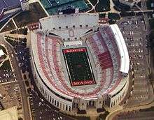
There is only one program in the Power Five conferences, the Ohio State Buckeyes, who play in the Big Ten Conference. The football team is fifth in all-time winning percentage, with a 922–326–53 overall record and a 24–26 bowl record as of 2019. The program has produced seven Heisman Trophy winners, forty conference titles, and eight undisputed national championships. The men's basketball program has appeared in the NCAA Division I Men's Basketball Tournament 27 times.
In the Group of Five conferences, the Cincinnati Bearcats play as a member of the American Athletic Conference. Their men's basketball team has over 1,800 wins, 33 March Madness appearances, and is currently on a nine-year streak of appearances as of 2019. Six teams are represented in the Mid-American Conference: the Akron Zips, Bowling Green Falcons, Kent State Golden Flashes, Miami RedHawks, Ohio Bobcats and the Toledo Rockets. The MAC headquarters are in Cleveland. The Cincinnati–Miami rivalry game has been played in southwest Ohio every year since 1888, and is the oldest current non-conference NCAA football rivalry.
Other Division I schools, either part of the NCAA Division I Football Championship Subdivision or not fielding in football include the Cleveland State Vikings, Xavier Musketeers, Wright State Raiders, and Youngstown State Penguins. Xavier's men's basketball has performed particularly well, with 27 March Madness appearances. Youngstown State's football has the third most NCAA Division I Football Championship wins, with 3.
There are 12 NCAA Division II universities and 22 NCAA Division III universities in Ohio.
State symbols
See also
- Index of Ohio-related articles
- Outline of Ohio
Notes
- "Ohio's State Motto". Ohio Historical Society. July 1, 2005. Archived from the original on October 6, 2007. Retrieved March 27, 2009.
- "Ohio's State Symbols". Ohio Governor's Residence and State Garden. Archived from the original on April 23, 2009. Retrieved March 26, 2009.
- "Ohio's State Rock Song". Ohio Historical Society. July 1, 2005. Archived from the original on February 7, 2009. Retrieved March 27, 2009.
- Mary Stockwell (2006). Ohio Adventure. Gibbs Smith. p. 88. ISBN 978-1-4236-2382-3. Archived from the original on March 31, 2015. Retrieved June 16, 2015.
- "The Admission of Ohio as a State". United States House of Representatives. Archived from the original on November 10, 2019. Retrieved November 10, 2019.
- "Ohio Quick Facts". Ohio Historical Society. Archived from the original on February 8, 2009. Retrieved March 26, 2009.
- "City of Columbus: Fun Facts". City of Columbus, Ohio. 2006. Archived from the original on May 1, 2009. Retrieved March 26, 2009.
- According to the U.S. Census July 2017 Annual Estimate , Greater Columbus is the largest Metropolitan statistical area (MSA) that is entirely within Ohio, with a population of 2,078,725; and Greater Cincinnati is the largest MSA that is at least partially within Ohio, with a population of 2,179,082, approximately 25% of which is in Indiana or Kentucky. Which MSA is the largest in Ohio depends on the context.
- "Elevations and Distances in the United States". United States Geological Survey. 2001. Archived from the original on July 22, 2012. Retrieved October 24, 2011.
- Elevation adjusted to North American Vertical Datum of 1988.
- "Median Annual Household Income". The Henry J. Kaiser Family Foundation. Archived from the original on December 20, 2016. Retrieved December 9, 2016.
- "Why is Ohio known as the Buckeye State and why are Ohioans known as Buckeyes?" (PDF). November 1998. Archived (PDF) from the original on April 12, 2019. Retrieved December 7, 2018.
- Bureau, U.S. Census. "American FactFinder—Results". factfinder2.census.gov. Archived from the original on February 12, 2020. Retrieved October 17, 2012.
- "Official USPS Abbreviations". United States Postal Service. 1998. Archived from the original on March 28, 2009. Retrieved March 26, 2009.
- "Quick Facts About the State of Ohio". Ohio History Central. Archived from the original on November 27, 2010. Retrieved July 2, 2010.
From Iroquois word meaning 'great river'
- Mithun, Marianne (1999). "Borrowing". The Languages of Native North America. Cambridge: Cambridge University Press. pp. 311–3. ISBN 978-0-521-29875-9.
Ohio ('large creek')
- "Native Ohio". American Indian Studies. Ohio State University. Archived from the original on February 2, 2007. Retrieved February 25, 2007.
Ohio comes from the Seneca (Iroquoian) ohiiyo' 'good river'
- William M. Davidson (1902). A History of the United States. Scott, Foresman and Company. p. 265. Retrieved June 16, 2015.
- Berg-Andersson, Richard E. (2000). "The Math Behind the 2000 Census Apportionment of Representatives". The Green Papers. Archived from the original on January 6, 2009. Retrieved March 25, 2009.
- Pollard, Kelvin (2008). "Swing, Bellwether, and Red and Blue States". Population Reference Bureau. Archived from the original on December 7, 2008. Retrieved March 25, 2009.
- TOP 10 STATES FOR MANUFACTURING 2019 Retrieved December 31, 2019
- "Transportation delivers for Ohio". Ohio: Department of Transportation. February 12, 2003. Archived from the original on January 24, 2008. Retrieved December 22, 2005. Cite journal requires
|journal=(help) - "Ohio Coastal Counties". Ohio: Department of Natural Resources. Archived from the original on August 30, 2008. Retrieved September 3, 2008. Cite journal requires
|journal=(help) - "Ohio v. Kentucky, 444 U.S. 335". Find law. January 21, 1980. Archived from the original on August 28, 2014. Retrieved August 15, 2016. Cite journal requires
|journal=(help) - "History of the Appalachian Regional Commission". Appalachian Regional Commission. Archived from the original on December 22, 2005. Retrieved January 3, 2006. Cite journal requires
|journal=(help) - "Counties in Appalachia" Archived September 17, 2008, at the Wayback Machine, Appalachian Regional Commission. Retrieved January 3, 2006.
- "GCT-T1 Ohio County Population Estimates—2005", The United States Census Bureau, retrieved January 3, 2006. True summation of Ohio Appalachia counties population (1,476,384) obtained by adding the 29 individual county populations together (July 1, 2005 data). Percentage obtained by dividing that number into that table's estimate of Ohio population as of July 1, 2005 (11,464,042)
- "The History of the MCD: The Conservancy Act". Miami Conservancy District. Archived from the original on March 14, 2007. Retrieved January 13, 2007.
- "State of Emergency in 37 Ohio Counties Declared". www.governor.ohio.gov. March 20, 2019. Archived from the original on March 22, 2019. Retrieved March 21, 2019.
- "Ohio climate averages". Weatherbase. Archived from the original on October 9, 2015. Retrieved November 12, 2015.
- "All-Time Temperature Maximums By State (2003)" (PDF). National Climatic Data Center. Archived from the original on March 3, 2013. Retrieved November 7, 2006.
- "All-Time Temperature Minimums By State (2003)" (PDF). National Climatic Data Center. Archived (PDF) from the original on December 29, 2008. Retrieved November 7, 2006.
- McLeod, Jaime (February 6, 2012). "The Great Blizzard of 1899: Deep South, Deep Freeze". The Farmer's Almanac. Archived from the original on February 6, 2016. Retrieved February 5, 2016.
- Hansen, Michael C. (2015). "Earthquakes in Ohio" (PDF). Ohio Department of Natural Resources, Division of Geological Survey. Archived (PDF) from the original on December 24, 2018. Retrieved June 13, 2019. Cite journal requires
|journal=(help) - Baranoski, Mark T. (2013). "Structure Contour Map on the Precambrian Unconformity Surface in Ohio and Related Basement Features" (PDF). Ohio Department of Natural Resources, Division of Geological Survey. Archived (PDF) from the original on February 3, 2017. Retrieved June 13, 2019. Cite journal requires
|journal=(help) - "OhioSeis Earthquake FAQ: What was the biggest earthquake in Ohio?". Ohio Department of Natural Resources, Division of Geological Survey. Archived from the original on April 10, 2019. Retrieved June 13, 2019.
- Historic Earthquakes: Western Ohio Archived December 13, 2007, at the Wayback Machine, U.S. Geological Survey.
- "Historic United States Earthquakes. Ohio". US: Geological Survey. Archived from the original on October 7, 2009. Cite journal requires
|journal=(help) - "Historic Earthquakes. Near Lima, OH, 1884‐9‐19". US: Geological Survey. Archived from the original on September 9, 2009. Cite journal requires
|journal=(help) - "Historic Earthquakes. Near Portsmouth, OH, 1986‐1‐31". US: Geological Survey. Archived from the original on September 9, 2009. Cite journal requires
|journal=(help) - "Historic Earthquakes. Northeast Ohio, 1986‐1‐31". US: Geological Survey. Archived from the original on September 9, 2009. Cite journal requires
|journal=(help) - "Northeastern Ohio Quake, January 1986". Ohio Department of Natural Resources, Division of Geological Survey. Archived from the original on April 29, 2019. Retrieved June 13, 2019. Cite journal requires
|journal=(help) - "Magnitude 4.0—Youngstown‐Warren urban area, OH". US: Geological Survey. Archived from the original on January 7, 2012. Retrieved December 31, 2011. Cite journal requires
|journal=(help) - "M 4.0—5km NNW of Eastlake, Ohio". US: Geological Survey. Archived from the original on June 11, 2019. Retrieved June 13, 2019. Cite journal requires
|journal=(help) - "Ohio (USA): State, Major Cities, Villages & Places". City Population. July 1, 2019. Archived from the original on June 5, 2019. Retrieved November 13, 2019.
- "OMB Bulletin No. 17-01: Revised Delineations of Metropolitan Statistical Areas, Micropolitan Statistical Areas, and Combined Statistical Areas, and Guidance on Uses of the Delineations of These Areas" (PDF). United States Office of Management and Budget. August 15, 2017. Archived (PDF) from the original on January 21, 2019. Retrieved March 6, 2018.
- "Annual Estimates of the Resident Population: April 1, 2010 to July 1, 2018—United States—Metropolitan Statistical Area; and for Puerto Rico". 2018 Population Estimates. United States Census Bureau, Population Division. February 2020. Archived from the original on February 13, 2020. Retrieved February 18, 2020.
- "Annual Estimates of the Resident Population: April 1, 2010 to July 1, 2018—United States—Combined Statistical Area; and for Puerto Rico". United States Census Bureau, Population Division. February 2020. Archived from the original on February 13, 2020. Retrieved February 18, 2020.
- Knepper (1989), p. 9.
- Knepper (1989), p. 10.
- Knepper (1989), p. 11.
- Douglas T. Price; Gary M. Feinman (2008). Images of the Past, 5th edition. New York: McGraw-Hill. pp. 274–277.
- Knepper (1989), p. 13.
- "Monongahela culture-AD 1050-1635". Fort Hill Archeology. Retrieved 2010-01-14.
- Knepper (1989), p. 14.
- Roseboom (1967), p. 20.
- Petun, Erie, Chonnonton, Wyandot, the Mingo Seneca & the Iroquois Confederacy
- Miami, Mascouten Lenape Shawnee & Odawa
- Mosopelea
- louis, franquelin, jean baptiste. "Franquelin's map of Louisiana". LOC.gov. Retrieved August 17, 2017.
- Knepper (1989), pp. 14–17.
- Knepper (1989), pp. 43–44.
- "Pontiac's Rebellion" Archived April 3, 2009, at the Wayback Machine, Ohio History Central, July 1, 2005.
- Cayton (2002), p. 3.
- "Religion and the Congress of the Confederation, 1774–89". Library of Congress. Archived from the original on May 2, 2012. Retrieved April 11, 2012.
- An act to provide for the due execution of the laws of the United States, within the state of Ohio, ch. 7, 2 Stat. 201 (February 19, 1803).
- Blue, Frederick J. (Autumn 2002). "The Date of Ohio Statehood". Ohio Academy of History Newsletter. Archived from the original on September 11, 2010.
- Joint Resolution for admitting the State of Ohio into the Union, (Pub.L. 83–204, 67 Stat. 407, enacted August 7, 1953).
- "Clearing up the Confusion surrounding OHIO's Admission to Statehood". Archived from the original on October 17, 2009. Retrieved October 30, 2009.
- Knepper (1989), pp. 233–234.
- Roseboom and Weisenburger (1967), p. 188.
- "Morgan's Raid—Ohio History Central". www.ohiohistorycentral.org. Archived from the original on June 21, 2018. Retrieved April 2, 2018.
- Cayton (2002), p. 129.
- Morris (1992), pp. 10–11.
- Cayton (2002), pp. 128–129.
- Resident Population Data. "Resident Population Data—2010 Census". 2010.census.gov. Archived from the original on October 19, 2013. Retrieved February 18, 2012.
- "QuickFacts Ohio; UNITED STATES". 2019 Population Estimates. United States Census Bureau, Population Division. February 18, 2020. Archived from the original on December 27, 2018. Retrieved February 18, 2020.
- "Census of Population: 1970, Part 37—Ohio, Section 1" (PDF). United States Census Bureau. 1970. Archived (PDF) from the original on April 15, 2010. Retrieved March 27, 2009.
- Balistreri, Kelly (February 2001). "Ohio Population News: Why did Ohio lose a seat in the U.S. House of Representatives?" (PDF). Center for Family and Demographic Research at Bowling Green State University. Archived from the original (PDF) on May 16, 2008. Retrieved March 27, 2009.
- "2000 Population and Geographic Centers of Ohio" (PDF). Ohio Department of Development, Office of Strategic Research. March 2001. Archived from the original (PDF) on November 24, 2005. Retrieved March 26, 2009.
- "Population and Population Centers by State: 2000". United States Census Bureau. Archived from the original on May 8, 2013. Retrieved December 6, 2008.
- "Americans under age 1 now mostly minorities, but not in Ohio: Statistical Snapshot Archived July 14, 2016, at the Wayback Machine". The Plain Dealer. June 3, 2012.
- "Archived copy" (PDF). Archived (PDF) from the original on September 11, 2017. Retrieved June 10, 2017.CS1 maint: archived copy as title (link)
- "Archived copy" (PDF). Archived (PDF) from the original on February 14, 2017. Retrieved June 10, 2017.CS1 maint: archived copy as title (link)
- "Archived copy" (PDF). Archived (PDF) from the original on August 31, 2017. Retrieved June 10, 2017.CS1 maint: archived copy as title (link)
- "Archived copy" (PDF). Archived (PDF) from the original on June 3, 2018. Retrieved May 7, 2018.CS1 maint: archived copy as title (link)
- "Archived copy" (PDF). Archived (PDF) from the original on February 1, 2019. Retrieved February 21, 2019.CS1 maint: archived copy as title (link)
- "Data" (PDF). www.cdc.gov. Retrieved December 21, 2019.
- Bureau, U. S. Census. "American FactFinder—Results". factfinder.census.gov. Archived from the original on March 5, 2014.
- Bureau, U. S. Census. "American FactFinder—Results". factfinder.census.gov. Archived from the original on December 18, 2014.
- "Historical Census Statistics on Population Totals By Race, 1790 to 1990, and By Hispanic Origin, 1970 to 1990, For The United States, Regions, Divisions, and States". July 25, 2008. Archived from the original on July 25, 2008.
- "Population of Ohio: Census 2010 and 2000 Interactive Map, Demographics, Statistics, Quick Facts".
- "US Census Bureau 2010 Census". www.census.gov. Retrieved December 6, 2017.
- "American FactFinder—Results". factfinder2.census.gov. Archived from the original on February 12, 2020. Retrieved September 6, 2013.
- "American FactFinder—Results". factfinder2.census.gov. Archived from the original on January 18, 2015. Retrieved March 28, 2013.
- Bureau, U.S. Census. "American FactFinder—Results". factfinder2.census.gov. Archived from the original on February 12, 2020. Retrieved March 20, 2013.
- "Data Center Language List". Archived from the original on September 30, 2015. Retrieved December 2, 2019.
- "Religious Composition of Ohio". The Pew Forum on Religion & Public Life. 2008. Archived from the original on March 6, 2008. Retrieved March 27, 2009.
- "Jewish Population in the United States, by State". Jewish Virtual Library. Archived from the original on October 21, 2013. Retrieved May 14, 2013.
- "The Association of Religion Data Archives | State Membership Report". www.thearda.com. Archived from the original on December 17, 2013. Retrieved December 16, 2013.
- "Amish Studies: "Population Change 2010–2015"" (PDF). Archived from the original (PDF) on March 4, 2016.
- "Religious Landscape Study". May 11, 2015. Archived from the original on March 17, 2018. Retrieved March 16, 2018.
- "Archived copy". Archived from the original on November 11, 2019. Retrieved November 11, 2019.CS1 maint: archived copy as title (link)
- "Site Selection Rankings". Greyhill Advisors. Archived from the original on November 6, 2011. Retrieved October 17, 2011.
- "Columbus Chamber Announces Ohio Ranked on 'Top 10 Business Climates' List for 2009" Archived September 8, 2012, at the Wayback Machine, Earth Times. Retrieved November 19, 2009.
- Analysis, US Department of Commerce, BEA, Bureau of Economic. "Bureau of Economic Analysis". www.bea.gov. Archived from the original on August 31, 2017. Retrieved March 10, 2018.
- "Economic Overview" (PDF). Ohio Department of Development. February 2009. Archived from the original (PDF) on March 26, 2009. Retrieved March 31, 2009.
- "Business Tax Index 2009" Archived April 19, 2009, at the Wayback Machine, SMALL BUSINESS & ENTREPRENEURSHIP COUNCIL. Retrieved December 2, 2009.
- "SMALL BUSINESS SURVIVAL INDEX 2009" Archived December 28, 2009, at the Wayback Machine, SMALL BUSINESS & ENTREPRENEURSHIP COUNCIL. Retrieved December 2, 2009.
- "The Best States for Business" Archived July 10, 2011, at the Wayback Machine, Directorship. Retrieved December 2, 2009.
- "The Best States For Business" Archived May 10, 2018, at the Wayback Machine, Forbes. Retrieved December 2, 2009.
- "Best Colleges 2010" Archived December 2, 2009, at the Wayback Machine, U.S. News & World Report. Retrieved December 2, 2009.
- "Best High Schools: State by State Statistics" Archived April 30, 2009, at the Wayback Machine, U.S. News & World Report. Retrieved December 2, 2009.
- Ohio unemployment rate 4.5% in February; state gained 13,400 jobs Archived March 24, 2018, at the Wayback Machine Retrieved March 24, 2018
- Bls.gov Archived July 25, 2018, at the Wayback Machine; Local Area Unemployment Statistics
- "Jobless rates fall again in southeastern Ohio" Archived November 1, 2013, at the Wayback Machine, Zanesville Times-Recorder. June 23, 2010. Retrieved June 25, 2010.
- Olivera Perkins (May 22, 2015) Ohio's unemployment rate up to 5.2 percent: 5 things you need to know Archived May 25, 2015, at the Wayback Machine Cleveland.com.
- "Strickland: Mature leader needed, rival Kasich is too radical" Archived June 28, 2010, at the Wayback Machine, Dayton Daily News. June 22, 2010. Retrieved June 25, 2010.
- Ohio Household Income Archived April 6, 2018, at the Wayback Machine Accessed March 24, 2018
- Archived March 25, 2018, at the Wayback Machine Retrieved March 24, 2018
- Manufacturing a High-Wage Ohio Archived March 24, 2018, at the Wayback Machine Accessed March 24, 2018
- Ohio Remains Among The Top Three States for Manufacturing Employment and Wages Archived March 25, 2018, at the Wayback Machine Retrieved March 24, 2018
- "Economic Overview" Archived March 26, 2009, at the Wayback Machine, Ohio Department of Development, p. 1. Retrieved November 19, 2009.
- "Fortune 500 2008". . May 5, 2008. Archived from the original on February 26, 2009. Retrieved March 31, 2009.
- "Lottery Results". Office of Citizen Services and Communications, General Services Administration. Archived from the original (SHTML) on November 27, 2011. Retrieved March 31, 2009.
- "About the Ohio Lottery". Ohio Lottery Commission. 2008. Archived from the original on March 31, 2009. Retrieved March 31, 2009.
- Kissell, Margo R. (March 24, 2009). "Englewood Man Wins $250,000 in Lottery". Dayton Daily News. Englewood, O.H. Archived from the original on March 27, 2009. Retrieved March 31, 2009.
- Vitale, Marty (May 29, 2014). "Report to SCOH". Louisville, Kentucky: Special Committee on U.S. Route Numbering, American Association of State Highway and Transportation Officials. Archived from the original (Office Open XML) on May 31, 2014. Retrieved June 1, 2014.
- "Constitution Online". Ohio General Assembly. Archived from the original on March 4, 2016. Retrieved March 25, 2009.
- "Constitution Online". Ohio General Assembly. Archived from the original on March 4, 2016. Retrieved March 25, 2009.
- "Constitution Online". Ohio General Assembly. Archived from the original on April 4, 2016. Retrieved March 25, 2009.
- "The Governors of Ohio". Ohio Historical Society. January 8, 2007. Archived from the original on June 5, 2011. Retrieved March 25, 2009.
- "Constitution Online". Ohio General Assembly. Archived from the original on October 1, 2018. Retrieved March 25, 2009.
- "Constitution Online". Ohio General Assembly. Archived from the original on March 4, 2016. Retrieved March 25, 2009.
- "Constitution Online". Ohio General Assembly. Archived from the original on March 4, 2016. Retrieved March 25, 2009.
- "Ohio District Courts of Appeal". Ohio Judiciary System. Archived from the original on May 14, 2009. Retrieved March 25, 2009.
- "The Supreme Court of Ohio Jurisdiction & Authority". The Ohio Judicial System. Archived from the original on March 14, 2009. Retrieved March 25, 2009.
- "Constitution Online". Ohio General Assembly. 2009. Archived from the original on April 4, 2016. Retrieved March 25, 2009.
- "Ohio General Assembly". Ohio History Central. July 1, 2005. Archived from the original on August 28, 2008. Retrieved March 25, 2009.
- "Population represented by state legislators—Ballotpedia". Archived from the original on March 18, 2017. Retrieved March 6, 2017.
- "Government". Congressman Michael Turner. Archived from the original on March 25, 2009. Retrieved March 25, 2009.
- "State Nicknames—Nicknames of U.S. States". Geography.about.com. Archived from the original on December 5, 2010. Retrieved July 2, 2010.
- Ann Heinrichs (January 1, 2003). Ohio. Capstone. p. 42. ISBN 978-0-7565-0316-1. Archived from the original on September 6, 2015. Retrieved June 16, 2015.
- "The Odds Of An Electoral College-Popular Vote Split Are Increasing". FiveThirtyEight. November 1, 2016. Archived from the original on December 21, 2016. Retrieved November 6, 2016.
- Trolling the Campuses for Swing-State Votes Archived May 28, 2015, at the Wayback Machine, Julie Salamon, "The New York Times", October 2, 2004
- Game Theory for Swingers Archived February 1, 2011, at the Wayback Machine, Jordan Ellenberg, "Slate.com", October 25, 2004
- Holli (1999), p. 162.
- " A grain of sand for your thoughts" Archived February 26, 2006, at the Wayback Machine, The Economist, December 20, 2005. Retrieved December 23, 2005.
- "Weekly Voter Statistics For Ohio—May 4, 2019". Ohio Voter Project. May 5, 2019. Archived from the original on May 6, 2019. Retrieved May 5, 2019.
- "Ohio Voters Are More Likely to be Old, White, Without Higher Education and Non-Affiliated with a Political Party". Clevescene. Archived from the original on May 6, 2019. Retrieved May 6, 2019.
- Riskind, Jonathan (December 24, 2008). "Ohio likely to lose 2 seats in Congress in 2012". Columbus Dispatch. Archived from the original on May 10, 2011. Retrieved March 29, 2009.
- "Rep. Marcy Kaptur (D-OH) Urges Homeowners to Stay in Foreclosed Homes". Democracy Now. February 3, 2009. Archived from the original on February 11, 2009. Retrieved March 29, 2009.
- "Ohio—Election Results 2010—The New York Times". Archived from the original on February 28, 2015. Retrieved December 24, 2014.
- "Senators of the 111th Congress". United States Senate. Archived from the original on March 25, 2009. Retrieved March 29, 2009.
- "The Right to Decide When to Vote: Husted v. A. Philip Randolph Institute". ACLU. September 13, 2017. Missing or empty
|url=(help) - Ford, Matt (May 30, 2017). "Use It or Lose It?". The Atlantic. Archived from the original on June 29, 2019. Retrieved May 15, 2019.
- Clinton, Hillary Rodham, What Happened (New York: Simon & Schuster, 2017), p. 419
- "Archived copy". Archived from the original on February 24, 2019. Retrieved February 24, 2019.CS1 maint: archived copy as title (link)
- "Thomas J. Hennen's American Public Library Ratings for 2006" (PDF). Archived from the original (PDF) on October 28, 2008.
- "Average Statewide Scores". Archived from the original on October 29, 2008.
- "The Official Site of the Cincinnati Reds". Major League Baseball. Archived from the original on April 4, 2008. Retrieved March 28, 2009.
- "The Official Site of the Cleveland Indians". Major League Baseball. Archived from the original on March 15, 2009. Retrieved March 28, 2009.
- "Major League Soccer Teams". Major League Soccer. Archived from the original on February 21, 2009. Retrieved March 28, 2009.
- "NBA.com Team Index". National Basketball Association. Archived from the original on March 18, 2009. Retrieved March 28, 2009.
- "NFL Teams". National Football League. Archived from the original on February 23, 2011. Retrieved March 28, 2009.
- "NHL Teams". National Hockey League. Archived from the original on March 11, 2009. Retrieved March 28, 2009.
- Griffith, Grant (2007). "Legend of the Cincinnati Red Stockings". Cincinnati Vintage Base Ball Club. Archived from the original on July 24, 2008. Retrieved March 28, 2009.
- "Ohio Attorney General". Ohio Attorney General. Archived from the original on February 3, 2013. Retrieved July 6, 2009.
- "Herb Capital of Ohio". Ohio Historical Society. July 1, 2005. Archived from the original on February 10, 2010. Retrieved March 27, 2009.
References
- Cayton, Andrew R. L. (2002). Ohio: The History of a People. Columbus, OH: The Ohio State University Press. ISBN 0-8142-0899-1
- Knepper, George W. (1989). Ohio and Its People. Kent, OH: Kent State University Press. ISBN 978-0-87338-791-0
- Mithun, Marianne (1999). Languages of Native North America. Cambridge, UK: Cambridge University Press.
- Morris, Roy, Jr. (1992). Sheridan: The Life and Wars of General Phil Sheridan. New York: Crown Publishing. ISBN 0-517-58070-5.
- Holli, Melvin G. (1999). The American Mayor. State College, PA: Pennsylvania State University Press. ISBN 0-271-01876-3
- Roseboom, Eugene H.; Weisenburger, Francis P. (1967). A History of Ohio. Columbus: The Ohio Historical Society.
External links
- State of Ohio Official Website
- Ohio State Facts from USDA
- U.S. Census Bureau (Ohio Quick Facts)
- USGS real-time, geographic, and other scientific resources of Ohio
- Thunder in the Heartland: A Chronicle of Outstanding Weather Events in Ohio, by Dr. Thomas Schmidlin and Jeanne Appelhans Schmidlin; The Kent State university Press; Kent, Ohio, 1996. ISBN 978-0873385497
- Ohio at Curlie

| Preceded by Tennessee |
List of U.S. states by date of admission to the Union Admitted on March 1, 1803 (17th) |
Succeeded by Louisiana |
| ||||||||||||||||||||||||||||||||||||||||||||||||||||||||||||||||
| Authority control |
|
|---|