Pierre, South Dakota
Pierre (/pɪər/;[6] Lakota: čhúŋkaške, lit. 'fort'[7]) is the capital of the U.S. state of South Dakota and the seat of Hughes County.[8] The population was 13,646 at the 2010 census, making it the second-least populous state capital in the United States, following Montpelier, Vermont. It is the eighth-most populous city in South Dakota. Founded in 1880, it was selected as the state capital when the territory was admitted as a state. Pierre is the principal city of the Pierre Micropolitan Statistical Area, which includes all of Hughes and Stanley counties.
Pierre | |
|---|---|
State capital city | |
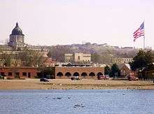
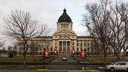 The South Dakota State Capitol building in downtown Pierre | |
| Motto(s): "On The River-On The Move" | |
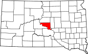
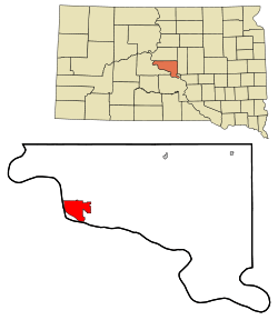 Location within Hughes County in South Dakota | |
 Pierre Location within the United States | |
| Coordinates: 44°22′21″N 100°19′12″W | |
| Country | United States |
| State | South Dakota |
| County | Hughes |
| Founded | 1880 |
| Incorporated | 1883[1] |
| Named for | Pierre Chouteau Jr. |
| Government | |
| • Mayor | Steve Harding |
| Area | |
| • Total | 13.05 sq mi (33.80 km2) |
| • Land | 13.03 sq mi (33.74 km2) |
| • Water | 0.02 sq mi (0.05 km2) 0.08% |
| Elevation | 1,453 ft (442 m) |
| Population | |
| • Total | 13,646 |
| • Estimate (2018)[4] | 13,980 |
| • Density | 1,073.16/sq mi (414.34/km2) |
| Time zone | UTC−6 (Central) |
| • Summer (DST) | UTC−5 (Central) |
| ZIP code | 57501 |
| Area code(s) | 605 |
| FIPS code | 46-49600 |
| GNIS feature ID | 1266887[5] |
| Website | City of Pierre |
History
The city was founded in 1880 on the east bank of the Missouri River opposite Fort Pierre, a former trading post that developed as a community. Pierre was designated as the state capital when South Dakota gained statehood on November 2, 1889.
Huron challenged the city to be selected as the capital, but Pierre was selected because of its location in the geographic center of the state. Fort Pierre had developed earlier, with a permanent settlement since about 1817 around a fur trading post. Fort Pierre Chouteau, preceding the city, was named after Pierre Chouteau, Jr., a major American fur trader from St. Louis, Missouri, who was of colonial French origin.
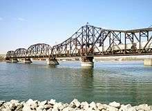
Development of Pierre was also influenced by construction of the Rapid City, Pierre and Eastern Railroad, which runs east–west through the city. It increased access to markets for regional products and improved transportation for passengers. The railroad crosses the Missouri River on the Chicago and North Western Railroad Bridge.
But the capital city became relatively isolated in the post-World War II era of federally subsidized highway construction, as travelers and freight companies began to use automobiles and trucking. It is one of four state capitals that is not served by an interstate highway, and it is alone in not having access to an expressway. Railways still serve in the Plains states, however.
Geography

Pierre is located at 44°22′21″N 100°19′12″W.[9]
According to the United States Census Bureau, the city has a total area of 13.07 square miles (33.85 km2), of which, 13.06 square miles (33.83 km2) is land and 0.01 square miles (0.03 km2) is water.[10]
Pierre is sited on rough river bluffs above the east bank of the Missouri River, overlooking its expanse. It is a few miles away from Lake Oahe, one of the largest man-made lakes in the world. Developed for flood control and irrigation, the lake has become a popular fishing destination.
Climate
Pierre has a relatively dry, four-season, humid continental climate (Köppen: Dfa),[11] with long, dry, cold winters, hot summers, and brief spring and autumnal transitions; as with much of the southern half of the state, it lies in USDA Plant Hardiness in zone 5.[12] According to weather maps and their data used as a basis, Pierre can be considered a semi-arid cold climate (Köppen: Bsk) aided by its precipitation near the threshold[13] that reaches even northeast of the city in South Dakota. As such, it is the only capital of the Midwest's states with a non-humid climate.[14][15] The monthly daily average temperature ranges from 19.9 °F (−6.7 °C) in January to 75.4 °F (24.1 °C), though the diurnal temperature variation is significantly greater during summer than in winter. Snow primarily falls in light amounts, with the snowiest months being February and March, while the average seasonal total is 32 inches (0.81 m). In addition, there are 20 nights per year with lows below 0 °F (−17.8 °C),[16] and cold conditions are often intensified by the high winds of the Great Plains. Summers often see spikes in temperature, with 6.4 days of highs above 100 °F (37.8 °C) and 36−37 days with highs above 90 °F (32.2 °C).[16]
On July 23, 1973, an F3 tornado struck Pierre and caused 10 injuries.[17] It was the strongest tornado ever recorded in Hughes County.[18]
The beginning of both May and October represent the last and first, respectively, freezing nights of the cooler season.[16] Precipitation is much lighter in the winter months than it is in late spring and summer, and totals about 20 inches (508 mm) annually. Extremes have ranged from −35 °F (−37 °C) on February 9, 1994 to 117 °F (47 °C) on July 15, 2006.
| Climate data for Pierre, South Dakota (Pierre Regional Airport), 1981−2010 normals | |||||||||||||
|---|---|---|---|---|---|---|---|---|---|---|---|---|---|
| Month | Jan | Feb | Mar | Apr | May | Jun | Jul | Aug | Sep | Oct | Nov | Dec | Year |
| Record high °F (°C) | 68 (20) |
75 (24) |
88 (31) |
98 (37) |
105 (41) |
112 (44) |
117 (47) |
114 (46) |
108 (42) |
98 (37) |
87 (31) |
77 (25) |
117 (47) |
| Average high °F (°C) | 30.0 (−1.1) |
34.9 (1.6) |
45.4 (7.4) |
59.7 (15.4) |
70.2 (21.2) |
80.0 (26.7) |
88.8 (31.6) |
87.3 (30.7) |
76.5 (24.7) |
61.0 (16.1) |
44.1 (6.7) |
31.3 (−0.4) |
59.1 (15.1) |
| Average low °F (°C) | 9.8 (−12.3) |
13.8 (−10.1) |
23.5 (−4.7) |
34.2 (1.2) |
45.7 (7.6) |
55.4 (13.0) |
61.9 (16.6) |
60.1 (15.6) |
49.2 (9.6) |
36.4 (2.4) |
23.3 (−4.8) |
12.1 (−11.1) |
35.6 (2.0) |
| Record low °F (°C) | −33 (−36) |
−35 (−37) |
−19 (−28) |
1 (−17) |
21 (−6) |
34 (1) |
42 (6) |
39 (4) |
21 (−6) |
4 (−16) |
−18 (−28) |
−31 (−35) |
−35 (−37) |
| Average precipitation inches (mm) | .42 (11) |
.59 (15) |
1.23 (31) |
1.81 (46) |
3.15 (80) |
3.57 (91) |
2.61 (66) |
1.80 (46) |
1.87 (47) |
1.65 (42) |
.76 (19) |
.55 (14) |
20.01 (508) |
| Average snowfall inches (cm) | 5.4 (14) |
6.0 (15) |
5.8 (15) |
3.5 (8.9) |
0 (0) |
0 (0) |
0 (0) |
0 (0) |
0 (0) |
.9 (2.3) |
4.8 (12) |
4.8 (12) |
31.3 (80) |
| Average precipitation days (≥ 0.01 in) | 5.7 | 4.7 | 6.3 | 8.2 | 10.2 | 10.7 | 9.2 | 7.4 | 6.8 | 6.8 | 5.9 | 5.8 | 87.7 |
| Average snowy days (≥ 0.1 in) | 5.1 | 3.8 | 3.5 | 1.9 | 0 | 0 | 0 | 0 | 0 | .6 | 3.1 | 4.3 | 22.3 |
| Source: NOAA (extremes 1933–present)[16][19] | |||||||||||||
Demographics
| Historical population | |||
|---|---|---|---|
| Census | Pop. | %± | |
| 1890 | 3,235 | — | |
| 1900 | 2,306 | −28.7% | |
| 1910 | 3,656 | 58.5% | |
| 1920 | 3,209 | −12.2% | |
| 1930 | 3,659 | 14.0% | |
| 1940 | 4,322 | 18.1% | |
| 1950 | 5,715 | 32.2% | |
| 1960 | 10,088 | 76.5% | |
| 1970 | 9,699 | −3.9% | |
| 1980 | 11,973 | 23.4% | |
| 1990 | 12,906 | 7.8% | |
| 2000 | 13,876 | 7.5% | |
| 2010 | 13,646 | −1.7% | |
| Est. 2018 | 13,980 | [4] | 2.4% |
| U.S. Decennial Census[20] 2018 Estimate[21] | |||
2010 census
As of the census[3] of 2010, there were 13,646 people, 5,778 households, and 3,463 families living in the city. The population density was 1,044.9 inhabitants per square mile (403.4/km2). There were 6,159 housing units at an average density of 471.6 per square mile (182.1/km2). The racial makeup of the city was 85.1% White, 0.5% African American, 10.9% Native American, 0.6% Asian, 0.5% from other races, and 2.4% from two or more races. Hispanic or Latino people of any race were 1.9% of the population.
There were 5,778 households of which 29.2% had children under the age of 18 living with them, 45.7% were married couples living together, 10.4% had a female householder with no husband present, 3.8% had a male householder with no wife present, and 40.1% were non-families. 35.0% of all households were made up of individuals and 11% had someone living alone who was 65 years of age or older. The average household size was 2.23 and the average family size was 2.87.
The median age in the city was 39.3 years. 22.9% of residents were under the age of 18; 7.5% were between the ages of 18 and 24; 26.7% were from 25 to 44; 28.9% were from 45 to 64; and 13.9% were 65 years of age or older. The gender makeup of the city was 47.8% male and 52.2% female.
2000 census
As of the census of 2000, there were 13,876 people, 5,567 households, and 3,574 families living in the city. The population density was 1,065.8 people per square mile (411.5/km²). There were 5,949 housing units at an average density of 457.0 per square mile (176.4/km²). The racial makeup of the city was 88.91% White, 0.20% African American, 8.56% Native American, 0.46% Asian, 0.02% Pacific Islander, 0.29% from other races, and 1.56% from two or more races. Hispanics or Latinos of any race were 1.25% of the population.
There were 5,567 households, out of which 32.9% had children under the age of 18 living with them, 51.6% were married couples living together, 9.5% had a female householder with no husband present, and 35.8% were non-families. 31.5% of all households were made up of individuals, and 10.7% had someone living alone who was 65 years of age or older. The average household size was 2.35, and the average family size was 2.96.
In the city, the population was spread out, with 27.2% under the age of 18, 6.5% from 18 to 24, 28.6% from 25 to 44, 23.6% from 45 to 64, and 14.1% who were 65 years of age or older. The median age was 38 years. For every 100 females, there were 90.5 males. For every 100 females age 18 and over, there were 85.4 males.
As of 2000 the median income for a household in the city was $42,962, and the median income for a family was $52,144. Males had a median income of $32,969 versus $22,865 for females. The per capita income for the city was $20,462. About 5.5% of families and 7.8% of the population were below the poverty line, including 7.9% of those under age 18 and 9.2% of those age 65 or over.
Transportation
Public transit is provided by River Cities Public Transit.
The city's Pierre Regional Airport is served by one commercial airline.
Although in the center of the state, Pierre is one of only four state capitals not served by an Interstate highway (along with Dover, Delaware, Jefferson City, Missouri, and Juneau, Alaska). It is the only one that is not served by any expressways.[22] The nearest Interstate highway is Interstate 90, about 34 mi (55 km) south of Pierre via the four-lane U.S. Highway 83.I-390 is proposed to connect Pierre to I-90.
The Rapid City, Pierre and Eastern Railroad runs east–west through the city. The railroad crosses the Missouri River on the Chicago and North Western Railroad Bridge.
Education
The Pierre School District oversees three elementary schools, a middle school and a high school, T. F. Riggs High School. The only private school is St. Joseph, a Catholic elementary school. It is administered by the local parish and the Diocese of Sioux Falls.
Media
Television
| Television | |||||
|---|---|---|---|---|---|
| Channel (Digital) |
Callsign | Network | Owner | Web site | |
| 7.1 | K14IO-D (Translator of KTTW) | Fox | Independent Communications | ||
| 11.1 | KPLO-LD (Translator of KELO) | CBS | Nexstar Media Group | ||
| 11.2 | KPLO-LD (Translator of KELO) | MyNetworkTV | Nexstar Media Group | ||
| 13.1 | KPRY (Satellite of KSFY) | ABC | Gray Television | ||
| 13.2 | KPRY (Satellite of KSFY) | The CW | Gray Television | ||
| 13.3 | KPRY (Satellite of KSFY) | MeTV | Gray Television | ||
| 34.1 | K34GM-D | Three Angels Broadcasting Network | Danny Shelton | ||
| 46.1 | K27HJ-D (Translator of KDLT) | NBC | Red River Broadcasting | ||
| 46.2 | K27HJ-D (Translator of KDLT) | Antenna TV | Red River Broadcasting | ||
AM radio
| AM radio stations | |||||
|---|---|---|---|---|---|
| Frequency | Call sign | Name | Format | Owner | City |
| 1060 AM | KGFX | Classic Country | Dakota Radio Group | Pierre | |
| 1240 AM | KCCR | Full Service | Riverfront Broadcasting LLC | Pierre | |
FM radio
| FM radio stations | |||||||
|---|---|---|---|---|---|---|---|
| Frequency | Call sign | Name | Format | Owner | Target city/market | City of license | |
| 89.1 FM | KVFL | VCY America | Christian | VCY America | Pierre | Pierre | |
| 89.5 FM | K208FM | Moody Radio | Christian WJSO translator | Moody Bible Institute | Pierre | Pierre | |
| 90.3 FM | KSLP | Power 107.3 | Contemporary Christian KSLT translator | Bethesda Christian Broadcasting | Pierre | Fort Pierre | |
| 91.7 FM | KTSD | South Dakota Public Broadcasting | NPR | SD Board of Directors for Educational Telecommunications | Pierre | Reliance | |
| 92.7 FM | KGFX-FM | River 92.7 | CHR | Dakota Radio Group | Pierre | Pierre | |
| 94.5 FM | KPLO-FM | 94 Country | Country | Dakota Radio Group | Pierre | Reliance | |
| 95.3 FM | KLXS | Country 95.3 | Country | Riverfront Broadcasting LLC | Pierre | Pierre | |
| 96.3 FM | K242CH | South Dakota Public Broadcasting | NPR | SD Board of Directors for Educational Telecommunications | Pierre | Pierre | |
| 100.1 FM | KJBI | 100.1 The Eagle | Classic Hits | Dakota Radio Group | Pierre | Fort Pierre | |
| 100.5 FM | K263AW | 94 Country | Country | Dakota Radio Group | Pierre | Fort Pierre | |
| 104.5 FM | KCCR-FM | Capitol City Rock 104.5 | Active Rock | Riverfront Broadcasting LLC | Pierre | Blunt | |
| 105.1 FM | KPGN-LP | Pierre's Good News Station | Christian | Pierre Educational Radio, Inc | Pierre | Pierre | |
| 107.1 FM | K296FI | 1060 KGFX | Classic Country KGFX-AM translator | Dakota Radio Group | Pierre | Pierre | |
Newspaper
The Capital Journal is the local newspaper and has been in circulation since 1881. OaheTV is the local Public/Education/Government cable channel serving Pierre, Fort Pierre on Midcontinent Communications Cable.
Notable people
- Floyd Bannister, pitcher in Major League Baseball
- Joseph Bottum, writer
- Tom Brokaw, television journalist and author
- Robert Gleckler, actor
- Dusty Johnson, current U.S. Representative from South Dakota. (born in Pierre in 1976).
- John Thune, current senior U.S. Senator from South Dakota (born in Pierre in 1961).
- Rex Robbins, actor
- Mike Rounds, current junior U.S. Senator from South Dakota and former Governor of South Dakota. (resident of Pierre).
In popular culture
In 2015, in honor of the 80th anniversary of the "Monopoly" board game, Hasbro held an online vote to determine which cities should be included in an updated version of the "Here and Now: The US Edition" of the game. The top "Boardwalk" spot went to an unexpected contender: Pierre. It received the most votes, beating New York, Los Angeles, Chicago, and Boston.[23][24] The outcome may have been influenced by the image that accompanied the name of the city in the balloting: the well-known Mount Rushmore. But the sculpture is 150 miles west of Pierre, in Keystone and the Black Hills section of the state.[25]
Pierre's attractions include the Oahe Dam and its associated lake, popular for recreation such as fishing. The world's largest Menards, a regional home improvement store, opened in the city in .[26]
References
- William D. Halsey, ed. (1976). "Pierre". Collier's Encyclopedia. 19. New York: Macmillan Educational Corporation. pp. 42–43.
- "2018 U.S. Gazetteer Files". United States Census Bureau. Retrieved February 22, 2020.
- "U.S. Census website". United States Census Bureau. Retrieved June 21, 2012.
- "Population and Housing Unit Estimates". United States Census Bureau. June 27, 2019. Retrieved June 4, 2019.
- "US Board on Geographic Names". United States Geological Survey. October 25, 2007. Archived from the original on February 26, 2012. Retrieved January 31, 2008.
- "Broadcast Pronunciation Guide and South Dakota Pronunciations". Associated Press. Archived from the original on June 14, 2011. Retrieved November 10, 2009.
- Ullrich, Jan F. (2014). New Lakota Dictionary (2nd ed.). Bloomington, IN: Lakota Language Consortium. ISBN 978-0-9761082-9-0. Archived from the original on October 18, 2016. Retrieved February 13, 2014.
- "Find a County". National Association of Counties. Archived from the original on May 31, 2011. Retrieved June 7, 2011.
- "US Gazetteer files: 2010, 2000, and 1990". United States Census Bureau. February 12, 2011. Retrieved April 23, 2011.
- "US Gazetteer files 2010". United States Census Bureau. Archived from the original on January 25, 2012. Retrieved June 21, 2012.
- Peel, M. C., Finlayson, B. L., and McMahon, T. A.: Updated American map of the Köppen-Geiger climate classification. Archived June 28, 2011, at the Wayback Machine Earth Syst. Sci., 11, 1633–1644, 2007.
- "What is my arborday.org Hardiness Zone?". Retrieved 9 April 2016.
- Data, US Climate. "Climate Pierre - South Dakota and Weather averages Pierre - Weather history january 2018". www.usclimatedata.com. Archived from the original on October 17, 2018. Retrieved October 16, 2018.
- "Interactive United States Koppen-Geiger Climate Classification Map". www.plantmaps.com. Archived from the original on October 11, 2018. Retrieved October 16, 2018.
- "Updated Köppen-Geiger climate map of the world". people.eng.unimelb.edu.au. Retrieved October 16, 2018.
- "Station Name: SD PIERRE RGNL AP". National Oceanic and Atmospheric Administration. Retrieved March 10, 2013.
- "Archived copy". Archived from the original on April 4, 2018. Retrieved 2018-04-03.CS1 maint: archived copy as title (link)
- "Archived copy". Archived from the original on April 4, 2018. Retrieved April 3, 2018.CS1 maint: archived copy as title (link)
- National Weather Service Corporate Image Web Team. "National Weather Service Climate". Archived from the original on February 11, 2014. Retrieved April 9, 2016.
- United States Census Bureau. "Census of Population and Housing". Retrieved September 23, 2013.
- "Population Estimates". United States Census Bureau. Retrieved February 28, 2020.
- "The Dwight D. Eisenhower System of Interstate and Defense Highways - Part VII - Miscellaneous Interstate Facts". Federal Highway Administration. Archived from the original on July 16, 2018. Retrieved June 3, 2018.
- Burbach, Kevin (March 19, 2015). "Pierre Gets Top Spot on New Monopoly Game". Argus Leader. Retrieved March 20, 2015.
- "Monopoly". BuzzFeed. Archived from the original on 20 March 2016. Retrieved 9 April 2016.
- "Distance between Pierre, SD and Keystone, SD". www.distance-cities.com. Archived from the original on June 11, 2016. Retrieved June 9, 2016.
- Lee.zion@capjounrnal.com, Lee Zion. "Big Menards opens". Capital Journal. Archived from the original on May 17, 2016. Retrieved June 9, 2016.
External links
| Wikimedia Commons has media related to Pierre, South Dakota. |
| Wikisource has the text of the 1911 Encyclopædia Britannica article Pierre. |
- Pierre Chamber of Commerce
- Pierre city government official website
- Rawlins Municipal Library
- River Cities Public Transit
Municipalities and communities of Hughes County, South Dakota, United States | ||
|---|---|---|
| Cities |
|  Hughes County map |
| Town |
| |
| Township |
| |
| Indian reservation |
| |
| Unincorporated communities |
| |
| Footnotes | ‡This populated place also has portions in an adjacent county or counties | |
Pierre (capital) | ||
| Topics |
|  Seal of South Dakota |
| Society | ||
| Regions |
| |
| Larger cities pop. over 5,000 |
| |
| Smaller cities pop. 1,000 - 5,000 |
| |
| Largest CDPs pop. over 1,000 |
| |
| Largest towns pop. over 500 |
| |
| Counties |
| |
| Authority control |
|
|---|