Kongu Nadu
Kongu Nadu is a region comprising the western part of state of Tamil Nadu in India. It is bounded by the regions of Tondai Nadu on the east, on the south-east by Chola Nadu and on the south by Pandya Nadu.[2]
Kongu Nadu | |
|---|---|
Geographical Area | |
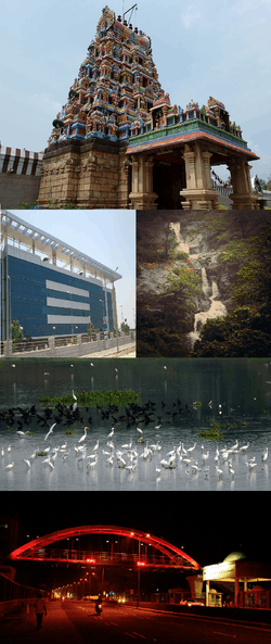 Coimbatore is the largest city in the region. | |
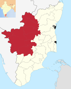 Kongu Nadu region within Tamil Nadu | |
| Coordinates: 11°1′48.925″N 77°2′21.544″E | |
| Country | |
| State | Tamil Nadu |
| Government | |
| • Body | Government of Tamil Nadu |
| Area | |
| • Total | 45,493 km2 (17,565 sq mi) |
| Population (2011)[1] | |
| • Total | 2,07,43,812 |
| • Density | 607/km2 (1,570/sq mi) |
| Languages | |
| • Official | Tamil |
| • Others | Kongu Tamil, Badaga, Toda, Irula |
| Time zone | UTC+5:30 (IST) |
| Largest city | Coimbatore |
| Literacy | 75.55% |
The region was ruled by the Cheras during Sangam period between c. 1st and the 4th centuries CE and it served as the eastern entrance to the Palakkad Gap, the principal trade route between the west coast and Tamil Nadu. The Kosar people mentioned in the second century CE Tamil epic Silappathikaram and other poems in Sangam literature is associated with the Coimbatore region. The region was located along an ancient Roman trade route that extended from Muziris to Arikamedu.The Gangas of Thalakkad ruled it for over 5 centuries.The medieval Cholas conquered the region in the 10th century CE. It came under the rule of the Vijayanagara Empire by the 15th century. After the Vijayanagara Empire fell in the 17th century, the Madurai Nayaks, who were the military governors of the Vijayanagara Empire established their state as an independent kingdom. In the latter part of the 18th century, the region came under the Kingdom of Mysore, following a series of wars with the Madurai Nayak dynasty. After the defeat of Tipu Sultan in the Anglo-Mysore Wars, the British East India Company annexed Kongu Nadu to the Madras Presidency in 1799. The region was hard hit during the Great Famine of 1876–78 resulting in nearly 200,000 famine related fatalities. The first three decades of the 20th century saw nearly 20,000 plague-related deaths and acute water shortage.[3] The region played a significant role in the Indian independence movement.
There have been demands and proposals to declare the region as a state of India.[4]
Etymology
The name Kongunadu draws its origin from the term `Kongu`, meaning nectar or honey. Kongu was later called as Kongunadu with the growth of civilization. Kongu Nadu is believed to have come from "Kongadesam", "Konga" a variant of the term "Ganga", meaning "Land of the Gangas".[5][6]
History

Kongu Nadu was one of the earliest and separate territorial divisions and home of the ancient Tamil people.[7] The river Kaveri flows in southeastern direction through the region.[8] Archaeological data from Kodumanal, a village on the banks of the Noyyal River, suggests the beginning of civilization around 4th century BCE.[9] Kodumanal was situated on the ancient trade route between across the Palghat gap in the Western Ghats and yielded remains belonging to the Sangam age.[10][11] Tamil-Brahmi writings were found on coins, seals and rings obtained from Amaravathi river bed near Karur, the erstwhile capital of the Cheras.[12][13] A musical inscription in Tamil Brahmi was found in a cave in Arachalur, dating from the 4th Century CE and Iravatham Mahadevan writes that these are syllables used in dance.[14][15]
The Kongu Country under the Cheras (400–600 CE)
The Kongu Nadu witnessed the rule of tribal chieftains during the Sangam period. 'Kongudesarajakkal Charitai'[16] mentions some dynasties which ruled this region. It was ruled by the Cheras during Sangam period between c. 1st and the 4th century CE. Chera dominance of the Kongu country began with the rule of the Palyanai Selkelu Kuttuvan who is the son of Uthiyan Cheralathan.[17] The successive Chera kings had Karur as the capital of the Kongu country. The location of Karur assumed military significance.[18]
After the Cheras, Rattas ruled the region. Then Gangas gained ascendancy after the Rattas. From the 7th century CE onwards, the conquest of the Kongu country had been the constant bone of contention between the Gangas and Pandyas.
Invasion by the Imperial Cholas of Tanjavur (900–1250 CE)
The medieval Cholas conquered the region in 10th century CE. The northern part of the Kongu country was brought under the Chola rule by Aditya I.[19] Raja Raja I in 990 A.D. defeated the Cheras at Kandalursalai and then proceeded against the Pandyas to annex Malai Nadu region which refers to the region of modern Coorg, Mysore and Kongu and the hills surrounding them. North Kongu was directly under the control of the Imperial Cholas till 1064 A.D.
For almost 300 years from 1004 C.E., the Kongu Cholas ruled autonomously. Chola monarch Raja Raja's general named, Kalimurka Vikrama was the founder of the dynasty and bore the title Konattar. The rulers of the 'Konattar' line adopted Chola titles and surnames.[20] They came from the Konadu region (Pudukkottai) and ruled a as branch of Tanjore Cholas but were named as Kongu Cholas. The Kongu country came under the control of Vikarama Chola and Rajadhiraja, the two Kongu rulers who served as the later contemporaries of the Imperial Chola king Rajendra I and Kulottunga I, who ruled between 1070 A.D. and 1120 A.D. Vikrama Chola III was the last ruler of the Kongu Chola line. During his time major parts of the Kongu region were under the Pandyas.
Imperial Pandyas Rule (1251–1318 CE)
From the 13th century A.D., particularly after the death of Vikarama Chola II the Pandyas tried to dominate the Kongu region. They annexed some parts of Kongu Nadu. The inscriptions in the Srirangam temple speaks of the victory of Jatavarman Sundara Pandyan I over the Kongu Nadu.[21] The glorious rule of the Pandyas came to an end with the death of Kulasekara Pandya who ruled Kongu Nadu between 1268 A.D. and 1318 A.D.
The Hoysalas conquered the Kongu Nadu and extended their rule. The Hoysala king Vira Someswara had matrimonial alliance with both Pandyas and Cholas. Vira Ballala III, successor of Vira Someswara ruled the region. After the decline of the Hoysalas the Kongu region came under the control of the Delhi Sultanate.
Vijayanagara Rule (1358–1667 CE)
The Vijayanagara rulers in the course of a series of campaigns succeeded in overthrowing the Muslims, and they held the title Mahamandaleswar and ruled the whole of South India. It was at this time that the Ummattur chieftains were apparently governing the dominion of Vijayanagara in Karnataka and Kongu region. The Umattur chieftains seem to have ruled over the Kongu country from 1446 to 1520 A.D. more or less peacefully rebuilding ruined temples and rehabilitating ruined towns damaged during the Muslim rule. Their rule ended when Krishnadeva Raya (1509 A.D -1529 A.D.) of Tuluva dynasty ascended to power.[22] The first record comes from Kokkarayapet (Salem district) which describes him as Rajakkal Tambiranar. In the 1550s, Madurai Nayaks, who were the military governors of the Vijayanagara Empire, took control of the region.
British India Period
After the Vijayanagara Empire fell in the 17th century, the Nayaks established their state as an independent kingdom and they introduced the Palayakkarar system.[23] In the latter part of the 18th century, the region came under the Kingdom of Mysore, following a series of wars with the Madurai Nayak dynasty. After the defeat of Tipu Sultan in the Anglo-Mysore Wars, the British East India Company annexed the region to the Madras Presidency in 1799. The region played a prominent role in the Second Poligar War (1801), when it was the area of operations of Dheeran Chinnamalai who fought against the rule of British East India Company.[24] One of the famous freedom fighters, Kodikaththa Kumaran, hailed from Chennimalai, was killed in Tiruppur during a protest for freedom. A memorial has been constructed at the place where he was killed and the road is named after him in order to hail his sacrifice for the nation.
Geography and population
Kongu Nadu region consists of 10 districts and some parts of taluks or small regions in other districts within Tamil Nadu such as Kalvarayan Taluk of Kallakurichi district, Thotiyyam, Western parts of Thuraiyur and Pachamalai hills of Trichy and Perambalur district. The Western Ghats mountain range passes through the region with major rivers Kaveri, Bhavani, Amaravati and Noyyal flowing through the region.[25] Palghat Gap, a mountain pass connects the neighbouring state of Kerala to the region.[26] The Eastern Ghats mountain range, which consists of the hills Kollimalai of Namakkal district, Shevaroy (Shervarayan) and Mettur Hills of Salem district and Palamalai of Coimbatore district, also passes through the region. The Biligiriranga Hills of Chamarajanagar District is located at the confluence of Eastern and Western Ghats belongs to the region. The Kaveri river flows into Tamil Nadu from Karnataka through Dharmapuri, Salem, Erode, Namakkal and Karur districts.
The table below lists geographic and demographic parameters for districts that constitute the 'Kongu Nadu region' of Tamil Nadu.[27]
| S.No. | Districts | Established | Area (km²) | Population (2011 Census) | Population density (/km²) | Taluks |
|---|---|---|---|---|---|---|
| 1 | Coimbatore | 1 November 1956 | 4,723[28] | 3,458,045[29] | 732 | |
| 2 | Dindigul | 15 September 1985 | 6036 | 2,159,775[31] | 358 | |
| 3 | Erode | 31 August 1979 | 5760 | 2,251,744[32] | 394 | |
| 4 | Karur | 30 September 1995 | 2,895.57 | 1,064,493 | 368 | |
| 5 | Dharmapuri | 2 October 1965 | 4,497.77 | 1,506,843 | 348 |
|
| 6 | Krishnagiri | 9 February 2004 | 5129 | 1,879,809 | 367 | |
| 7 | Namakkal | 1 January 1997 | 3363 | 1,726,601[33] | 513 | |
| 8 | Salem | 1 November 1956 | 5,205 | 3,482,056[34] | 669 | |
| 9 | Tiruppur | 22 February 2009 | 5,186.34 | 2,479,052[35] | 478 | |
| 10 | The Nilgiris District | February 1882 | 2,565 | 735,394 | 421.97 |
|
| Total | 45,493 | 2,07,43,812 | 607 |
Apart from the above-mentioned districts, minor parts of Palakkad, Kallakurichi, Idukki, Wayanad and Chamrajnagar districts are also fall under Kongu Nadu region.
Language
Tamil is the sole official language while English is an additional official language for communication purposes. Kongu Tamil is the dialect of Tamil language that is spoken in Kongu Nadu, which is the western region of Tamil Nadu[36] or "Kongalam"[37] or "Kanger" or "Kongappechu". Badaga is a spoken by approximately 130,000 people in the Nilgiri Hills of Kongu Nadu region. Toda, Irula, Kota are some of the languages spoken by tribal population of the Nilgiris district.
Economy
Kongu Nadu had a flourishing economy from ancient times and had trade contacts with foreign nations. Kodumanal was a 2,500-year-old industrial colony discovered by archaeologists.[38][39] The region was located along an ancient Roman trade route that extended from Muziris to Arikamedu.[40][41] A Chola highway called Rajakesari Peruvazhi ran through the region.[42][43]
Kongu Nadu is among the most industrialized regions in the country. Agriculture and textile industries contribute majorly to the economy of the region.[44] It is one of the major producers of textiles including cotton,[45] apparels and knit wear,[46] and hosieries, agricultural and allied products including milk, poultry,[47] turmeric, sugar-cane, rice, white silk, coconut and plantain, industrial products including paper, auto parts,[48] water pumps,[49] wet grinders,[50] jewelry,[51] aluminium and steel and IT services[52][53] in Tamil Nadu.[54] Kovai Cora cotton sarees, Coimbatore Wet Grinders, Salem silk sarees, Bhavani Jamakkalam, Toda Embroidery and Nilgiri tea are recognized geographical Indications from the region.[55][56] Coimbatore is called the "Manchester of South India" due to its extensive textile industry, fed by the surrounding cotton fields. Coimbatore is a major industrial centre and is one of the major producers of jewellery, engineering and auto components. Tiruppur is the largest producer and exporter of knit-wear in India. With 43% share, Erode district is the largest turmeric producer in Tamil Nadu.Dharapuram and Kangeyam are most famous for the coconut and rice mills. Gobichettipalayam is one of the major producers of white silk and coconuts. Pollachi and Oddanchatram are major producers of vegetables. Oddanchatram vegetable market is one of the biggest vegetable markets in Tamil Nadu. Namakkal is a transport hub and is the largest producer of poultry. Salem district has one of the largest magnesite, bauxite and iron ore deposits in India. Salem and Namakkal districts are among a few regions in Asia where tapioca productivity is high.[57] Karur and Erode are amongst the major producers of paper. Salem, Dharmapuri and Krishnagiri districts are leading producers of mango in India.
Statehood Demand
There are demands for the creation of separate state of Kongu Nadu, comprising the regions of western districts of Tamil Nadu.[58] There have been numerous claims that Kongu Nadu region has often been ignored by successive governments in spite of being the largest contributor to the state's economy. The entire region comprising 10 districts accounts for more than 65 percent of the revenue.[59] Some political outfits allege that this part of the country has been consistently ignored by the central and state government and this is well reflected from the fact that a city like Coimbatore, which is the second largest city in Tamil Nadu and with indomitable private entrepreneurial spirit doesn’t even have one public sector company. A number of political outfits name Kongunadu Makkal Katchi, Kongunadu Makkal Desia Katchi, Kongunadu Munnetra Kazhagam, Kongu Vellala Goundergal Peravai, Tamil Nadu Kongu Ilaignar Peravai, Kongu Desa Makkal Katchi, are active in the region claiming to fight for the rights of the region.[4][60][61][62]
Transport
Rail
Major towns are connected by the Indian railway network. Coimbatore, Salem, Tiruppur and Erode are the major stations under Southern Railway. Indian Railway has an electric and diesel loco shed at Erode.
Road
The region is well connected by roads. Tamil Nadu State Transport Corporation has two divisions headquartered at Coimbatore and Salem which serve major portion of Kongu Nadu. All cities of the region are well connected with the largest city Coimbatore and other parts of the region in Tamil Nadu as well as with the neighborhood states by both Government and Private buses.
Air
Coimbatore International Airport is the only international airport serving the region. It is the second largest airport in Tamil Nadu and has regular scheduled international and domestic flights to major destinations. Salem Airport is an operational domestic airport.
Cuisine
Kongu Nadu cuisine is predominantly South Indian with rice as its base and a collection of exotic recipes being created by the people residing in the Kongu region.
As it is also native to an arid area, the cuisine includes cereals like jowar (cholam), bajra (kambu), ragi (kezhvaragu), and different kinds of pulses and sesame. Food is served over a banana leaf.[63] Eating on a banana leaf is an old custom and imparts a unique flavor to the food and is considered healthy.[64] Idly, dosa, paniyaram and appam are popular dishes.[65][66][67][68] Kongu Nadu cuisine does not involve marination of any raw material and as a result the food has a different taste and unique texture. The best quality turmeric is grown in the region and this is an important ingredient in the cuisine. Turmeric is added into curries which gives the product a deep yellow colour and an aromatic substance.[69] The traditional Kongu people were mostly vegetarians for religious reason.[70] Arisi parupu sadam is unique to this region and frequently made in homes. Opputtu is a variant of Puran poli made with rice, chickpea, palm or cane jaggery, cardamom and ghee is also unique to this region.[71]
Places of interest
Kodaikanal, Aanamalai, Ooty, Conoor, Kothagiri, Kolli Hills, Yercaud, Elagiri, Valparai, Topslip, Palani, Metur Dam, Bhavani sagar Dam, Sathyamangalam Reserve Forest, Uthiyur hills and Mudumalai National Park are the major tourist destinations.
Temples
Palani Murugan temple, Magudeswarar Temple, Kodumudi, Namakkal Anjaneyar Temple, Bannari Amman Temple, Sivanmalai Murugan temple, Uthiyur hills Murugan temple and Marudhamalai (temple) are the important religious centres.
References
- "Census of India". Government of India. 2001. Archived from the original on 12 May 2008. Retrieved 26 October 2010.
- Thurston, Edgar; Rangachari, K. (1987). Castes and Tribes of Southern India. Asian Educational Services. pp. 156–. ISBN 978-81-206-0288-5.
- "The perils of the past". The Hindu. 28 May 2005. Retrieved 26 February 2018.
- "India may have 50 states if new demands met". Times of India. 4 August 2013. Retrieved 1 June 2016.
- Menon, P. Shungoonny (1 January 1998). History of Travancore from the Earliest Times. Asian Educational Services. pp. 33–. ISBN 978-81-206-0169-7.
- Ramamurthy, V. (1986). History of Kongu: Volume 1. p. 19.
- "On how Kongu Nadu was a Jain bastion". The Hindu. 12 October 2017. Retrieved 5 December 2019.
- Ramaswamy, Vijaya (2017). Historical Dictionary of the Tamils. Rowman & Littlefield. p. 217. ISBN 978-1-5381-0686-0.
- Singh, Upinder (2009). A History of Ancient and Early Medieval India: From the Stone Age to the 12th Century. Addison Wesley. ISBN 978-81-317-1120-0.
- Sasisekaran, B.; Raghunatha Rao, B. (1999). "I 999" (PDF). Indian Journal of History of Science. 34 (4). Archived from the original (PDF) on 20 January 2010. Retrieved 11 December 2010.
- Rajan, K.; Athiyaman, N. (2004). "Traditional Gemstone Cutting Technology of Kongu Region in Tamil Nadu" (PDF). Indian Journal of History of Science. 39 (4): 385–414. Archived from the original (PDF) on 21 July 2011.
- "Roman Karur". Tamilartsacademy.com. Archived from the original on 7 May 2012. Retrieved 3 May 2012.
- Rami Reddy, V.; Chandrasekhar Reddy, B.K. (2004). "Morphometric Status of Human Skeletal Remains From Kodumanal, Periyar District, Tamil Nadu" (PDF). Anthropologist. 6 (4): 104–112.
- Rao, Subha J. (1 October 2005). "Writing on the rock". The Hindu. Chennai, India. Retrieved 1 June 2016.
- Parthasarathy, Indira (2 August 2003). "Records and revelations". The Hindu. Archived from the original on 31 July 2010. Retrieved 1 June 2016.
- Padirruppattu, Third Ten, Verse - 22.
- Menon, A. Sreedhara (2011). Kerala History and its Makers. D C Books. p. 23. ISBN 9788126437825.
- Kalvettiyal, Madras, 1973, p.58.
- V, Ramamurthy (1986). History of Kongu. International Society for the Investigation of Ancient Civilization. p. 239.
- Thangamani, M.R. (1982). New Light on the History of the Kongu Cholas. Erode. p. 77.
- Chettiar, C.M. Ramachandra (1987). History of Kongu Nadu. Madras. p. 150.
- Arokiaswami, M (1956). The Kongu Country. Madras. p. 329.
- "The land called Kongunad". The Hindu. 19 November 2005. Retrieved 9 June 2010.
- "Remembering Dheeran Chinnamalai". The Hindu. 3 August 2007. Retrieved 15 January 2011.
- "The Peninsula". Asia-Pacific Mountain Network. Archived from the original on 12 August 2007. Retrieved 19 March 2007.
- "Britannica Encyclopedia". Retrieved 8 March 2015.
- "Districts of Tamil Nadu". Government of Tamil Nadu.
- "Coimbatore District Administration - Statistical HandBook". www.coimbatore.nic.in. Retrieved 27 January 2018.
- "Census Info 2011 Final population totals - Coimbatore district". Office of The Registrar General and Census Commissioner, Ministry of Home Affairs, Government of India. 2013. Retrieved 26 January 2014.
- "District Map of Coimbatore". Coimbatore District administration. 2009. Retrieved 24 January 2014.
- "Cencus". dindigul.nic.in. Retrieved 3 December 2019.
- "Census Info 2011 Final population totals - Erode district". Office of The Registrar General and Census Commissioner, Ministry of Home Affairs, Government of India. 2013. Retrieved 26 January 2014.
- "Census Info 2011 Final population totals - Namakkal district". Office of The Registrar General and Census Commissioner, Ministry of Home Affairs, Government of India. 2013. Retrieved 26 January 2014.
- "Census Info 2011 Final population totals - Salem district". Office of The Registrar General and Census Commissioner, Ministry of Home Affairs, Government of India. 2013. Retrieved 26 January 2014.
- "Census Info 2011 Final population totals - Tiruppur district". Office of The Registrar General and Census Commissioner, Ministry of Home Affairs, Government of India. 2013. Retrieved 26 January 2014.
- Severine Silva. Toponomy of Canara. p. 34.
In the southern part of Mysore the Tamil language is at this day named the Kangee, from being best known to them as the language of the people of Kangiam
- F. Poezold, William Simpson (1809). Oxford University https://books.google.com/books?id=KlYIAAAAQAAJ&pg=PT69. Missing or empty
|title=(help) - "A 2,500-year-old industrial estate". Rediff. Retrieved 1 June 2016.
- Subramanian, T. S (28 January 2007). "Roman connection in Tamil Nadu". The Hindu. Retrieved 28 October 2011.
- "Kovai's Roman connection". The Hindu. 8 January 2009. Retrieved 9 June 2010.
- "On the Roman Trail". The Hindu. 21 January 2008. Retrieved 9 June 2010.
- Vanavarayar, Shankar (21 June 2010). "Scripting history". The Hindu. Retrieved 9 May 2011.
- M, Soundariya Preetha (30 June 2007). "Tale of an ancient road". The Hindu. Retrieved 9 May 2011.
- "When the Gods came down". The Hindu Business Line. 8 May 2014. Retrieved 7 March 2016.
- "State wise number of cotton mills" (PDF). Confederation of Textile Industry. Archived from the original (PDF) on 25 January 2016. Retrieved 23 January 2016.
- Chakrapani, Saranya (20 November 2014). "Coimbatore: Rise of the self-made city". India Today. Retrieved 7 March 2016.
- "Tamil Nadu Poultry Industry Seeks Export Concessions". Financial Express. Retrieved 28 March 2015.
- Yegya Narayanan, R. "Coimbatore's small auto component makers find the going tough". Business Line.
- "Poor sales hit pump unit owners, workers". Times of India. 26 May 2015. Retrieved 28 June 2015.
- "Poll code set to hit wet grinders business". Live Mint. 6 August 2015. Retrieved 20 September 2015.
- "India's Gems and Jewellery Market is Glittering". Resource Investor. Archived from the original on 26 September 2011. Retrieved 30 August 2011.
- Sujatha, S (13 January 2010). "Coimbatore gears up for IT revolution, Tidel park to be ready by April end". The Economic Times. Retrieved 7 March 2016.
- "Coimbatore: IT sector on the fast track". India Today. 22 April 2011. Retrieved 30 August 2011.
- "Indian Government press release". Press Information Bureau, Government of India. 31 October 2011. Archived from the original on 30 June 2015. Retrieved 31 January 2013.
- "Common facility for wet grinders". The Hindu. 5 August 2007. Retrieved 20 September 2009.
- "31 ethnic Indian products given GI protection". Financial Express. 4 April 2008. Retrieved 26 January 2016.
- Saqaf, Syed Muthahar (13 September 2014). "Good demand for tapioca in Salem". The Hindu. ISSN 0971-751X. Retrieved 11 November 2018.
- "KMDK seeks separate Kongu Naadu state". The New Indian Express. Retrieved 4 December 2019.
- "Campaign Reaches Fever Pitch in Revenue-Rich Kongu Nadu". News18. 1 April 2019. Retrieved 4 December 2019.
- "Region's 'neglect' by governments prompted party formation". Chennai Online. Archived from the original on 5 March 2016. Retrieved 1 June 2016.
- "Beginning with message of conservation". The Hindu. Chennai, India. 10 April 2009. Retrieved 1 June 2016.
- "KMP to work for progressive Western Tamil Nadu". The Hindu. Chennai, India. 29 April 2009. Retrieved 1 June 2016.
- "Serving on a banana leaf". ISCKON. Archived from the original on 14 January 2016. Retrieved 1 January 2016.
- "The Benefits of Eating Food on Banana Leaves". India Times. 9 March 2015.
- "Snack Street combines taste of street food with hygiene of restaurant". The Hindu. 19 July 2013. Retrieved 4 March 2016.
- Achaya, K.T. (1 November 2003). The story of our food. Universities Press. p. 80. ISBN 978-81-7371-293-7.
- Balasubramanian, D (21 October 2014). "Changes in the Indian menu over the ages". The Hindu.
- "Kovakkai, Kongunadu and Quizzing". The Hindu. 3 February 2011. Retrieved 1 October 2015.
- Nagarajan, Rema (26 March 2011). "Taste some cuisine from Kongunadu". Times of India. Retrieved 14 May 2016.
- Francis Hamilton; East India Company (1807). A journey from Madras through the countries of Mysore, Canara, and Malabar. T. Cadell and W. Davies. pp. 330–.
- "Kongu Food Info by Times : Kongunadu Cuisine". Times of India. 26 March 2011.
| State symbols |
| |
|---|---|---|
| Governance |
| |
| Topics | ||
| Major cities | ||
| Districts |
| |
| Lists | ||
| Proposed states |
|  |
|---|---|---|
| Proposed union territories |
| |