Vrbas, Serbia
Vrbas (Serbian Cyrillic: Врбас, Hungarian: Verbász) is a town and municipality located in the South Bačka District of the autonomous province of Vojvodina, Serbia. As of 2011, the town had a population of 24,112, while the municipality had 42,092 inhabitants.
Vrbas | |
|---|---|
Town and municipality | |
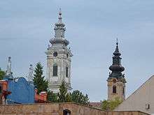
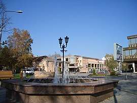  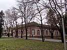 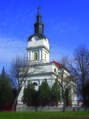 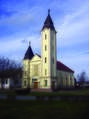 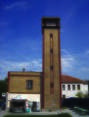 From top: Fountain in the center of Vrbas, Villa ,,Tabori", Vrbas Museum, The Greek Catholic Church, Methodist-evangelical church, Building of volunteer firefighting company | |
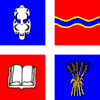 Flag  Coat of arms | |
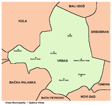
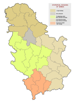
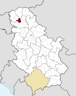 Location of the municipality of Vrbas within Serbia | |
| Coordinates: 45°34′N 19°39′E | |
| Country | |
| Province | Vojvodina |
| District | South Bačka |
| Settlements | 7 |
| Government | |
| • Mayor | Milan Glušac |
| Area | |
| • Municipality | 376 km2 (145 sq mi) |
| Elevation | 85 m (279 ft) |
| Population (2011 census)[2] | |
| • Town | 24,112 |
| • Municipality | 42,092 |
| Time zone | UTC+1 (CET) |
| • Summer (DST) | UTC+2 (CEST) |
| Postal code | 21460 |
| Area code | +381 21 |
| Car plates | VS |
| Website | www |
Name
Its name stems from the word "Willow" in the Serbian language. During the SFRY period, the town was renamed Titov Vrbas (meaning "the Vrbas of Tito"), after Josip Broz Tito. Like all other towns in Socialist Yugoslavia named after Tito, the first part was dropped once the new states were formed during the early 1990s.
In Rusyn, the town is known as Вербас, in Hungarian as Verbász, in Croatian as Vrbas, in German as Werbass, and in Turkish as Verbas.
History
Vrbas was mentioned first in 1213 during the administration of the Kingdom of Hungary. According to other sources, it was mentioned first in 1387.[3] In the 16th century it became a part of the Ottoman Empire. During Ottoman administration it was populated by ethnic Serbs.[4]
Since the Treaty of Passarowitz (1718), Vrbas and the Banat were placed under administration of the Habsburg Monarchy. According to the 1720 census, it was populated exclusively by Serbs (about 250 families[5]).[6]
After 1784 many Germans settled in the town founding a new settlement named Novi Vrbas (Neu-Verbasz) near the old Serb settlement, which then became known as Stari Vrbas (Old Vrbas).
In 1910, population of Novi Vrbas was mostly composed of ethnic Germans, while population of Stari Vrbas was ethnically mixed and was mainly composed of Serbs and Germans.[7]
In 1918, Vrbas became part of the Kingdom of Serbs, Croats and Slovenes, which was later renamed to Yugoslavia. The town was under Axis occupation in 1941–1944, and during that time it was attached to Horthy's Hungary. As a consequence of the World War II events in Yugoslavia, the German population fled from the town after this war. At the same time, many settlers from Montenegro came to Vrbas and other neighboring places.
Inhabited places
Vrbas municipality includes the city of Vrbas and the following villages:
Demographics
| Historical population | ||
|---|---|---|
| Year | Pop. | ±% p.a. |
| 1948 | 37,174 | — |
| 1953 | 37,614 | +0.24% |
| 1961 | 42,853 | +1.64% |
| 1971 | 43,490 | +0.15% |
| 1981 | 45,756 | +0.51% |
| 1991 | 46,405 | +0.14% |
| 2002 | 45,852 | −0.11% |
| 2011 | 42,092 | −0.95% |
| Source: [8] | ||
According to the 2011 census results, the municipality has 42,092 inhabitants.
Ethnic groups
Settlements with Serb ethnic majority are: Bačko Dobro Polje, Zmajevo, Kosančić, Ravno Selo and Vrbas. Ethnically mixed settlements are: Kucura (with relative Rusyn majority) and Savino Selo (with relative Montenegrin majority).
The ethnic composition of the municipality:[9]
| Ethnic group | Population | % |
|---|---|---|
| Serbs | 23,251 | 55.24% |
| Montenegrins | 7,353 | 17.47% |
| Rusyns | 3,375 | 8.02% |
| Hungarians | 2,464 | 5.85% |
| Ukrainians | 836 | 1.99% |
| Croats | 549 | 1.30% |
| Roma | 355 | 0.84% |
| Slovaks | 286 | 0.68% |
| Yugoslavs | 170 | 0.40% |
| Macedonians | 149 | 0.35% |
| Germans | 121 | 0.29% |
| Muslims | 112 | 0.27% |
| Albanians | 48 | 0.11% |
| Others | 3,023 | 7.18% |
| Total | 42,092 |
Economy
The following table gives a preview of total number of registered people employed in legal entities per their core activity (as of 2018):[10]
| Activity | Total |
|---|---|
| Agriculture, forestry and fishing | 385 |
| Mining and quarrying | - |
| Manufacturing | 2,710 |
| Electricity, gas, steam and air conditioning supply | 91 |
| Water supply; sewerage, waste management and remediation activities | 193 |
| Construction | 188 |
| Wholesale and retail trade, repair of motor vehicles and motorcycles | 1,326 |
| Transportation and storage | 806 |
| Accommodation and food services | 259 |
| Information and communication | 74 |
| Financial and insurance activities | 125 |
| Real estate activities | 12 |
| Professional, scientific and technical activities | 249 |
| Administrative and support service activities | 516 |
| Public administration and defense; compulsory social security | 547 |
| Education | 661 |
| Human health and social work activities | 1,081 |
| Arts, entertainment and recreation | 191 |
| Other service activities | 117 |
| Individual agricultural workers | 270 |
| Total | 9,802 |
Notable citizens
- Molter Károly, writer (1890–1981)
- Vida Ognjenović, writer and director (b. 1941)
- Desanka Pešut, sports shooter (b. 1941)
- Lazar Ristovski, actor (b. 1952)
- Radoman Božović, politician and former Prime Minister of Serbia (b. 1953)
- Miodrag Kostić, businessman (b. 1959)
- Svetozar Šapurić, footballer (b. 1960)
- Igor Marojević, Serbian writer (b. 1968)
- Milorad Mažić, football referee (b. 1973)
- Magdolna Rúzsa, singer (b. 1985)
- Slobodan Vuković, footballer (b. 1986)
- Nikola Komazec, footballer (b. 1987)
- Ljubomir Fejsa, footballer (b. 1988)
- Bianka Buša, volleyball player (b. 1994)
Gallery
 The Calvinist church.
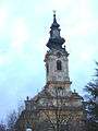 The Evangelical church.
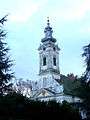
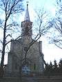 The Immaculate Conception of Blessed Virgin Mary Catholic Church.
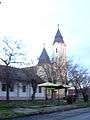 The Methodist church.
See also
- Municipalities of Serbia
- South Bačka District
- Bačka
- List of places in Serbia
- List of cities, towns and villages in Vojvodina
References
- Slobodan Ćurčić, Broj stanovnika Vojvodine, Novi Sad, 1996.
- "Municipalities of Serbia, 2006". Statistical Office of Serbia. Retrieved 2010-11-28.
- "2011 Census of Population, Households and Dwellings in the Republic of Serbia: Comparative Overview of the Number of Population in 1948, 1953, 1961, 1971, 1981, 1991, 2002 and 2011, Data by settlements" (PDF). Statistical Office of Republic Of Serbia, Belgrade. 2014. ISBN 978-86-6161-109-4. Retrieved 2014-06-27.
- Dr Slobodan Ćurčić, Naselja Bačke - geografske karakteristike, Novi Sad, 2007, page 220.
- Dr Slobodan Ćurčić, Naselja Bačke - geografske karakteristike, Novi Sad, 2007, page 220.
- Dr Slobodan Ćurčić, Naselja Bačke - geografske karakteristike, Novi Sad, 2007, page 220.
- Ivan Jakšić, Iz popisa stanovništva Ugarske početkom XVIII veka, Novi Sad, 1966.
- http://img190.imageshack.us/img190/3899/vojvodina1910.png
- "2011 Census of Population, Households and Dwellings in the Republic of Serbia" (PDF). stat.gov.rs. Statistical Office of the Republic of Serbia. Retrieved 10 April 2019.
- "Попис становништва, домаћинстава и станова 2011. у Републици Србији" (PDF). stat.gov.rs. Republički zavod za statistiku. Retrieved 10 April 2019.
- "MUNICIPALITIES AND REGIONS OF THE REPUBLIC OF SERBIA, 2019" (PDF). stat.gov.rs. Statistical Office of the Republic of Serbia. 25 December 2019. Retrieved 28 December 2019.
External links
| Wikimedia Commons has media related to Vrbas. |

