Tustin, California
Tustin is a city located in Orange County, California, in the Los Angeles metropolitan area. As of 2019, Tustin had a population of 79,348. The city is located next to the county seat, Santa Ana, and does not include North Tustin.
Tustin, California | |
|---|---|
City in California | |
.png) 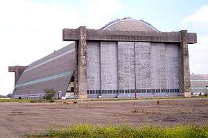 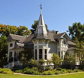 Clockwise from top: Tustin High School Student Quad, Old MCAS Base Tustin Blimp Hangar, Sherman Stevens House. | |
 Seal | |
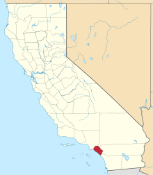
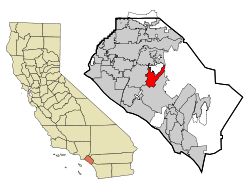 Location of Tustin within Orange County, California. | |
 Tustin, California Location in the United States | |
| Coordinates: 33°44′23″N 117°48′49″W | |
| Country | |
| State | |
| County | Orange[1] |
| Incorporated | September 21, 1927[2] |
| Government | |
| • Mayor | Chuck Puckett[3] |
| Area | |
| • Total | 11.11 sq mi (28.78 km2) |
| • Land | 11.11 sq mi (28.78 km2) |
| • Water | 0.00 sq mi (0.00 km2) 0% |
| Elevation | 138 ft (42 m) |
| Population (2010) | |
| • Total | 75,540 |
| • Estimate (2019)[5] | 79,348 |
| • Density | 7,411.70/sq mi (2,793.72/km2) |
| Time zone | UTC−8 (Pacific) |
| • Summer (DST) | UTC−7 (PDT) |
| ZIP codes | 92780–92782 |
| Area code(s) | 657/714, 949 |
| FIPS code | 06-80854 |
| GNIS feature IDs | 1661590, 2412117 |
| Website | www |
Because of a top 10% ranking in start-ups and sole proprietors per capita and one of the shortest commutes in Southern California, the city was chosen in 2009 by Forbes as one of the top 25 towns to live well in America.[6][7]
History
Members of the Tongva and Juaneño/Luiseño nations long inhabited this area. After the 1769 expedition of Gaspar de Portolà, a Spanish expedition led by Father Junipero Serra named the area Vallejo de Santa Ana (Valley of Saint Anne). On November 1, 1776, Mission San Juan Capistrano became the area's first permanent European settlement in Alta California, New Spain.
In 1801, the Spanish Empire granted 62,500 acres (253 km2) to Jose Antonio Yorba, which he named Rancho San Antonio. Yorba's great rancho included the lands where the cities and communities of Olive, Orange, Villa Park, Santa Ana, Tustin, Costa Mesa and Newport Beach stand today. Smaller ranchos evolved from this large rancho including the Rancho Santiago de Santa Ana.
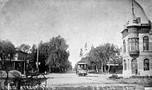
After the Mexican-American war, Alta California became part of the United States and American settlers arrived in this area. Columbus Tustin, a carriage maker from Northern California, founded the city in the 1870s on 1,300 acres (5 km²) of land from the former Rancho Santiago de Santa Ana. The city was incorporated in 1927 with a population of about 900. The townsite was bordered by Camino Real on the south, Newport Avenue on the east, 1st Street on the north, and the Costa Mesa Freeway on the west.
During World War II, a Navy anti-submarine airship base (later to become a Marine Corps helicopter station) was established on unincorporated land south of the city; the two dirigible hangars are among the largest wooden structures ever built and are listed on the National Register of Historic Places and ASCE List of Historic Civil Engineering Landmarks. Suburban growth after the war resulted in increased population, annexation of nearby unincorporated land including the base, and development of orchards and farmland into housing tracts and shopping centers.
Geography
Tustin is located at 33°44′23″N 117°48′49″W.[8] According to the United States Census Bureau, the city has a total area of 11.1 square miles (28.7 km²).
It is bordered by Irvine on the south and east, Orange and the census-designated Tustin Foothills on the north, and Santa Ana on the west.
Climate
Tustin has a Mediterranean climate (Köppen climate classification Csa).
| Climate data for Tustin | |||||||||||||
|---|---|---|---|---|---|---|---|---|---|---|---|---|---|
| Month | Jan | Feb | Mar | Apr | May | Jun | Jul | Aug | Sep | Oct | Nov | Dec | Year |
| Average high °F (°C) | 70 (21) |
71 (22) |
72 (22) |
75 (24) |
77 (25) |
80 (27) |
85 (29) |
87 (31) |
85 (29) |
80 (27) |
76 (24) |
70 (21) |
78 (26) |
| Average low °F (°C) | 47 (8) |
48 (9) |
50 (10) |
53 (12) |
58 (14) |
61 (16) |
65 (18) |
67 (19) |
63 (17) |
57 (14) |
50 (10) |
46 (8) |
56 (13) |
| Average precipitation inches (mm) | 2.96 (75) |
3.07 (78) |
2.79 (71) |
.77 (20) |
.28 (7.1) |
.10 (2.5) |
.01 (0.25) |
.14 (3.6) |
.34 (8.6) |
.40 (10) |
1.22 (31) |
1.79 (45) |
13.87 (352) |
| Source: NOAA [9] | |||||||||||||
Economy
Top employers
According to the City's 2013 Comprehensive Annual Financial Report,[10] the top employers in the city are:
| # | Employer | # of employees |
|---|---|---|
| 1 | Tustin Unified School District | 1,100 |
| 2 | Rockwell Collins | 600 |
| 3 | Ricoh | 500 |
| 4 | Costco | 450 |
| 5 | Safmarine | 400 |
| 6 | GE Power Electronics | 330 |
| 7 | City of Tustin | 300 |
| 8 | Tustin Hospital | 291 |
| 9 | Toshiba | 300 |
| 10 | MicroVention | 300 |
| 11 | Balboa Water Group | 253 |
| 12 | Kleen Impressions | 250 |
| 13 | Warner Systems | 250 |
Demographics
| Historical population | |||
|---|---|---|---|
| Census | Pop. | %± | |
| 1880 | 227 | — | |
| 1930 | 926 | — | |
| 1940 | 953 | 2.9% | |
| 1950 | 1,143 | 19.9% | |
| 1960 | 2,006 | 75.5% | |
| 1970 | 22,190 | 1,006.2% | |
| 1980 | 32,248 | 45.3% | |
| 1990 | 50,689 | 57.2% | |
| 2000 | 67,504 | 33.2% | |
| 2010 | 75,540 | 11.9% | |
| Est. 2019 | 79,348 | [5] | 5.0% |
| U.S. Decennial Census to 2010[11] | |||
2010
The 2010 United States Census reported that Tustin had a population of 75,540.[12] The population density was 6,816.7 people per square mile (2,632.0/km²). The racial makeup of Tustin was 39,729 (52.6%) White (34.8% Non-Hispanic White),[13] 1,722 (2.3%) African American, 442 (0.6%) Native American, 15,299 (20.3%) Asian, 268 (0.4%) Pacific Islander, 14,499 (19.2%) from other races, and 3,581 (4.7%) from two or more races. Hispanic or Latino of any race were 30,024 persons (39.7%).
The census reported that 75,020 people (99.3% of the population) lived in households, 340 (0.5%) lived in non-institutionalized group quarters, and 180 (0.2%) were institutionalized.
There were 25,203 households, 10,465 (41.5%) had children under the age of 18 living in them, 12,969 (51.5%) were opposite-sex married couples living together, 3,494 (13.9%) had a female householder with no husband present, 1,472 (5.8%) had a male householder with no wife present. There were 1,568 (6.2%) unmarried opposite-sex partnerships, and 193 (0.8%) same-sex married couples or partnerships. 5,178 households (20.5%) were one person and 1,403 (5.6%) had someone living alone who was 65 or older. The average household size was 2.98. There were 17,935 families (71.2% of households); the average family size was 3.46.
The age distribution was 20,212 people (26.8%) under the age of 18, 6,856 people (9.1%) aged 18 to 24, 25,033 people (33.1%) aged 25 to 44, 17,006 people (22.5%) aged 45 to 64, and 6,433 people (8.5%) who were 65 or older. The median age was 33.4 years. For every 100 females, there were 94.7 males. For every 100 females age 18 and over, there were 91.6 males.
There were 26,476 housing units at an average density of 2,389.2 per square mile, of the occupied units 12,813 (50.8%) were owner-occupied and 12,390 (49.2%) were rented.The homeowner vacancy rate was 1.3%; the rental vacancy rate was 5.8%. 36,783 people (48.7% of the population) lived in owner-occupied housing units and 38,237 people (50.6%) lived in rental housing units.
According to the 2010 United States Census, Tustin had a median household income of $74,011, with 12.2% of the population living below the federal poverty line.[13]
2000
As of the 2000 census, there were 67,504 people in 23,831 households, including 16,062 families, in the city.[14] The population density was 5,921.4 inhabitants per square mile (2,286.3/km²). There were 25,501 housing units at an average density of 2,236.9 per square mile (863.7/km²). The racial makeup of the city was 58.72% White, 2.92% African American, 0.66% Native American, 14.90% Asian, 0.30% Pacific Islander, 17.94% from other races, and 4.55% from two or more races. Hispanic or Latino of any race were 34.24% of the population.
Of the 23,831 households 36.8% had children under the age of 18 living with them, 50.2% were married couples living together, 12.3% had a female householder with no husband present, and 32.6% were non-families. 24.1% of households were one person and 5.2% were one person aged 65 or older. The average household size was 2.82 and the average family size was 3.37.
The age distribution was 26.8% under the age of 18, 9.3% from 18 to 24, 38.1% from 25 to 44, 18.6% from 45 to 64, and 7.1% 65 or older. The median age was 32 years. For every 100 females, there were 95.9 males. For every 100 females age 18 and over, there were 92.9 males.
The median household income was $55,985 and the median family income was $60,092. Males had a median income of $42,456 versus $33,688 for females. The per capita income for the city was $25,932. About 5.8% of families and 8.5% of the population were below the poverty line, including 10.8% of those under age 18 and 6.2% of those age 65 or over.
Government
Local
The Tustin City Council is composed of five members elected at large; the Mayorship rotates among the council members and is primarily a ceremonial role.
Mayor Allan Bernstein was elected to the Tustin City Council in 2012. In 2019, Letitia Clark was chosen to serve as Mayor Pro Tem, Charles E. "Chuck" Puckett, Barry Cooper, and Austin Lumbard also serve on the City Council as council members.[3]
Local politics in the late 1990s and early 2000s were dominated by the 1997 closure of the local Marine Corps Air Station and plans for subsequent commercial development of the land, including an unsuccessful bid by neighboring Santa Ana to build a school on the land, part of which is within Santa Ana Unified School District's territory.
Emergency services
Fire protection in Tustin is provided by the Orange County Fire Authority. Law enforcement is provided by the Tustin Police Department.
State and federal
In the California State Legislature, Tustin is in the 37th Senate District, represented by Republican John Moorlach, and in the 68th Assembly District, represented by Republican Steven Choi.[15]
In the United States House of Representatives, Tustin is in California's 45th congressional district, represented by Democrat Katie Porter.[16]
Education
Primary and secondary education in Tustin and surrounding unincorporated areas is overseen by the Tustin Unified School District. Tustin High School is a California Distinguished School, as is Foothill High School. Arnold O. Beckman High School is in the Best High Schools according to U.S. News & World Report.[17] Tustin High School is also well-known regionally for its strong Model United Nations program. Springfield College, a nonprofit, private, higher education institute, is located in the city of Tustin.
Neighborhood districts
- Tustin Ranch
- Tustin Legacy
- Tustin District
Points of interest
- The Market Place, formerly known as Tustin Market Place (official website)
- The District at Tustin Legacy (official website)
- Enderle Center (official website)
- Marconi Automotive Museum (official website)
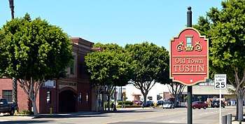
- Old Town Tustin (official website)
Notable people
Actors
- Cuba Gooding Jr., actor, best known for Oscar-winning role portraying the character Rod Tidwell in the movie Jerry Maguire, attended Tustin High School, but graduated from John F. Kennedy High School in Granada Hills, CA
- Rachel Kimsey, actress, best known for portraying the character Mackenzie Browning on the soap opera The Young and the Restless, graduated from Tustin High School
- Matthew Lillard, actor, best known for portraying the character Shaggy in the Scooby Doo movies and Stu Macher in the movie Scream graduated from Foothill High School
- John Locke, a fictional character, played by actor Terry O'Quinn on the television show Lost, is from Tustin
- Caroline Sunshine, actress, best known for portraying the character Tinka on Shake It Up (Disney), graduated from Orange Lutheran High School
Athletes
- Sam Baker, former NFL offensive tackle for Atlanta Falcons, graduated from Tustin High School
- James Beaumont "Beau" Bell, pro football player, former NFL linebacker for Cleveland Browns, graduated from Tustin High School
- Heath Bell, former MLB all-star closing pitcher for San Diego Padres, Tampa Bay Rays; graduated from Tustin High School
- Milorad Čavić, three-time Olympic swimmer for Serbia (2000, 2004, 2008), graduated from Tustin High School
- Chris Chester, NFL offensive lineman for Baltimore Ravens, Atlanta Falcons; graduated from Tustin High School
- Gerrit Cole, current MLB pitcher for New York Yankees, lived in Tustin [18]
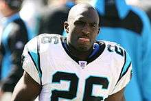
- DeShaun Foster, former NFL running back for Carolina Panthers and San Francisco 49ers, graduated from Tustin High School
- Evelyn Furtsch, swimmer, 1932 Summer Olympics, women's 400-meter relay team (Wilhemina von Brenen, Jeanette Rodgers, Evelyn Furtsch and Mary Carew) won gold medal with Olympic record of 47 seconds flat; graduated from Tustin High School
- Alfonso Gómez, current professional welterweight boxer and former contestant on The Contender, lived in Tustin
- Doug Gottlieb, ESPN analyst and host of The Doug Gottlieb Show on ESPN Radio, and former basketball point guard for Notre Dame and Oklahoma State University, graduated from Tustin High School
- Mark Grace, former MLB all-star first baseman for Chicago Cubs and Arizona Diamondbacks, broadcaster and coach, graduated from Tustin High School
- Shawn Green, former MLB all-star outfielder for Toronto Blue Jays, Los Angeles Dodgers, Arizona Diamondbacks, and New York Mets, graduated from Tustin High School
- Billy Hart, Minor League Baseball outfielder, attended Foothill High School
- Rex Hudler, former MLB utility player for New York Yankees, Baltimore Orioles, Montreal Expos, St. Louis Cardinals, California Angels, and Philadelphia Phillies, as well as for Tokyo Yakult Swallows of Nippon Professional Baseball league; former broadcaster for Los Angeles Angels of Anaheim, current broadcaster for the Kansas City Royals lived in Tustin
- Phil Hughes, MLB starting pitcher for Minnesota Twins, graduated from Foothill High School
- Matt Konan, professional hockey defense, currently playing for Lehigh Valley Phantoms as a Philadelphia Flyers' prospect
- Caitlin Lowe, former National Pro Fastpitch softball outfielder for USSSA Pride and for USA Softball in 2008 Beijing Olympics, graduated from Foothill High School
- Matt McCoy, former NFL linebacker for Seattle Seahawks, Philadelphia Eagles, New Orleans Saints, and Tampa Bay Buccaneers, graduated from Tustin High School
- Frostee Rucker, current NFL defensive end of Arizona Cardinals, graduated from Tustin High School
- Dave Staton, former MLB first baseman for San Diego Padres [18]
- Richard Umphrey III, former NFL center for New York Giants and San Diego Chargers, graduated from Tustin High School
- Zack Weiss, American-Israeli MLB pitcher.
Other
- Corky King, founder of Summum, graduated from Tustin High School
- Mary Kay Letourneau, daughter of US Representative John G. Schmitz and former schoolteacher, internationally publicized for being convicted in 1997 for statutory second degree rape of a 12-year-old student.[19]
See also
References
- "Tustin". Geographic Names Information System. United States Geological Survey. Retrieved January 21, 2015.
- "California Cities by Incorporation Date". California Association of Local Agency Formation Commissions. Archived from the original (Word) on November 3, 2014. Retrieved August 25, 2014.
- "City Council". City of Tustin, California. Retrieved January 7, 2019.
- "2016 U.S. Gazetteer Files". United States Census Bureau. Retrieved June 28, 2017.
- "Population and Housing Unit Estimates". Retrieved May 21, 2020.
- Woolsey, Matt (May 4, 2009). "America's Top 25 Towns To Live Well". Forbes. Retrieved May 4, 2009.
- Woolsey, Matt. "In Depth: America's Top 25 Towns To Live Well". forbes.com. Retrieved March 21, 2018.
- "US Gazetteer files: 2010, 2000, and 1990". United States Census Bureau. February 12, 2011. Retrieved April 23, 2011.
- (NCEI), National Centers for Environmental Information. "1981-2010 Normals - Data Tools - Climate Data Online (CDO) - National Climatic Data Center (NCDC)". www.ncdc.noaa.gov. Retrieved March 21, 2018.
- "City of Tustin, California - Film Permit" (PDF). www.tustinca.org. Retrieved March 21, 2018.
- "Census of Population and Housing". United States Census Bureau. Retrieved January 29, 2019.
- "U.S. Census website". United States Census Bureau. 2010. Retrieved January 29, 2019.
- "State & County QuickFacts: Tustin (city), California". United States Census Bureau. March 31, 2015. Archived from the original on April 2, 2015. Retrieved January 29, 2019.
- "California 2000" (PDF). United States Census Bureau. 2003. Retrieved January 29, 2019.
- "Statewide Database". UC Regents. Archived from the original on February 1, 2015. Retrieved December 18, 2014.
- "California's 45th Congressional District - Representatives & District Map". Civic Impulse, LLC.
- "U.S. News Best High Schools Rankings". U.S. News & World Report L.P.
- "TWLL players in the majors". twll.com. Retrieved March 21, 2018.
- Crimes of the Centuries: Notorious Crimes, Criminals, and Criminal Trials in ... - Google Books
Further reading
- Tustin, by Guy Ball, 2011, ISBN 0-7385-7037-0, Arcadia Publishing.
- Tustin: An Illustrated History, by Carol Jordan, reprinted 2010 by the Tustin Area Historical Society
External links
| Wikimedia Commons has media related to Tustin, California. |
- Official website

- Old Town Tustin
- Tustin Area Historical Society
- Tustin Police Department
- Tustin Photos at Orange County Archives
Orange County, California, United States | ||
| Areas | | |
| Schools | ||
| Transportation |
| |
| Landmarks | ||
Municipalities and communities of Orange County, California, United States | ||
|---|---|---|
| Cities |
|  Orange County map |
| CDPs | ||
| Unincorporated communities | ||
| Ghost towns | ||

| Authority control |
|
|---|