Stanthorpe, Queensland
Stanthorpe is a rural town and locality in the Southern Downs Region, Queensland, Australia.[2][3] In the 2016 census, Stanthorpe had a population of 5,406 people.[1] The area surrounding the town is known as the Granite Belt.
| Stanthorpe Queensland | |||||||||||||||
|---|---|---|---|---|---|---|---|---|---|---|---|---|---|---|---|
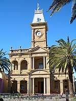 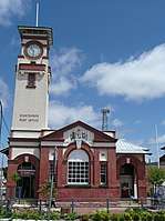 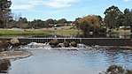 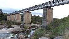 From left to right; Stanthorpe Parklands, Stanthorpe Town Hall, Stanthorpe Post Office, Quart Pot Creek Park, Quart Pot Creek Rail Bridge | |||||||||||||||
 Stanthorpe | |||||||||||||||
| Coordinates | 28.6547°S 151.935°E | ||||||||||||||
| Population | 5,406 (2016 census)[1] | ||||||||||||||
| • Density | 159.94/km2 (414.2/sq mi) | ||||||||||||||
| Postcode(s) | 4380 | ||||||||||||||
| Elevation | 811 m (2,661 ft) | ||||||||||||||
| Area | 33.8 km2 (13.1 sq mi) | ||||||||||||||
| Time zone | AEST (UTC) | ||||||||||||||
| Location |
| ||||||||||||||
| LGA(s) | Southern Downs Region | ||||||||||||||
| County | Bentinck | ||||||||||||||
| Parish | Stanthorpe, Broadwater, Folkestone | ||||||||||||||
| State electorate(s) | Southern Downs | ||||||||||||||
| Federal Division(s) | Maranoa | ||||||||||||||
| |||||||||||||||
| |||||||||||||||
Geography
Stanthorpe lies on the New England Highway near the New South Wales border 223 kilometres (139 mi) from Brisbane via Warwick, 56 kilometres (35 mi) north of Tenterfield and 811 m above sea level.[4]
Stanthorpe was developed around Quart Pot Creek which meanders from south-east through the centre of town and then out through the south-west, where its confluence with Spring Creek forms the Severn River. Quart Pot Creek forms part of the south-western boundary of the locality, while the Severn River forms part of the south-western boundary.[5]
The New England Highway passes through the town from Applethorpe to the north to Severnlea in the south. Originally it passed through the town centre along the main street, Maryland Street. However, it now bypasses to the west of the main developed area of the town. The Stanthorpe-Texas Road connects Stanthorpe to Broadwater to the west and then travels south-west to Texas.[5]
The land within the boundaries of Stanthorpe is primarily used for urban purposes: housing, recreational, commercial and industrial with some undeveloped land on the hillier slopes. Although an agricultural centre of the Granite Belt, there is little agriculture within the town's boundaries.[5] Crops grown in the surrounding area include vegetables, apples, grapes and stone fruit. Wine is also produced in the area, and sheep and cattle grazing is also prevalent.
History
Stanthorpe was founded by tin miners. People came from many countries to mine tin from 1872. Prior to 1872 this area boasted some large pastoral runs and a few prospectors in bark huts. At that time, the area was known as 'Quart Pot Creek'. The Private Township of Stannum existed in the area along one side of the present main street. With the discovery of tin and the influx of miners and new businesses, a 'more suitable' name was sought by the town fathers. Thus, Stanthorpe became the name which encompassed all, as this area became for a time, the largest alluvial tin mining and mineral field in Queensland. Stanthorpe literally means 'tintown', as Stannum is Latin for 'tin' and thorpe is Middle English for 'village'.[6] The Queensland Surveyor General, Augustus Charles Gregory, is credited with coining the name in 1872.[2]
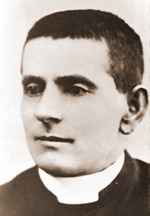
When the tin prices fell, many miners turned to farming. The subtropical highland climate was very suitable for growing cool climate fruits and vegetables. Grapes were first planted here in the 1860s with encouragement from the local Catholic parish priest Father Jerome Davadi to produce altar wine. His Italian descent made grape growing and wine production a familiar pastime and the notion caught on in the area. There were plenty of Italian settlers and wine was made for home enjoyment.
St Joseph's Catholic School was established in October 1872 by four Sisters of Mercy: Sisters M Agnes, Emilian, Muredach and Malachy.[7][8]
Stanthorpe State School opened on 9 March 1874.[7]
The railway reached Stanthorpe in May 1881.[9]
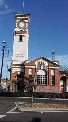
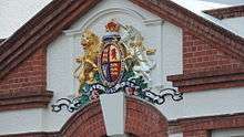
The Post Office with a clock tower and an elaborate coat of arms was constructed in Maryland Street in 1901 in the Arts and Crafts style.[10] Following Federation, the Commonwealth Government took charge of post and telegraphic services. However, they contracted the construction of post offices in Queensland to the Public Works Department of the Queensland Government and the Stanthorpe Post Office is believed to be one of the first ordered by the Commonwealth Government. It was designed by the first Commonwealth Government Architect John Smith Murdoch.[11][12]
The cool dry climate was valued as an aid to health from the early nineteenth century especially for those suffering from tuberculosis or chest conditions. Following the First World War, Stanthorpe was a major resettlement area for soldiers recovering from mustard gas exposure. Many of these Soldier Settlers took up the land leased to them in the areas around Stanthorpe which now bear the names of First World War battlefields.
Stanthorpe State High School opened on 23 January 1961.[7]
Stanthorpe Adventist Primary School opened on 25 January 1982 and closed on 2002.[7]
The College of Wine Tourism was opened in 2007.[13]
Heritage listings

Stanthorpe has a number of heritage-listed sites, including:
- 94 Greenup Street: El Arish[14]
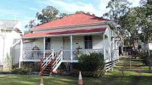
- 98 High Street: Masel Residence[15]
- 140 High Street: Central Hotel[16]
- 14 Maryland Street: Stanthorpe Post Office[17]
- Little Sundown Creek: Sundown Tin and Copper Mine[18]
- Lock Street: Stanthorpe Soldiers Memorial[19]
- Quart Pot Creek: Quart Pot Creek Rail Bridge[20]
- Warwick-Stanthorpe railway line: Cherry Gully Tunnel[21]
Climate
Owing to its elevation, Stanthorpe features a subtropical highland climate (Cfb). At an altitude of 811 metres (2,661 ft),[4] Stanthorpe holds the record for the lowest temperature recorded in Queensland at −10.6 °C (12.9 °F) on 23 June 1961.[22] Sleet and light snowfalls are occasionally recorded, with the most significant snowfall in over 30 years occurring on 17 July 2015.[23]
| Climate data for Stanthorpe (Stanthorpe Leslie Parade, 1957–2019) | |||||||||||||
|---|---|---|---|---|---|---|---|---|---|---|---|---|---|
| Month | Jan | Feb | Mar | Apr | May | Jun | Jul | Aug | Sep | Oct | Nov | Dec | Year |
| Record high °C (°F) | 37.8 (100.0) |
37.2 (99.0) |
34.2 (93.6) |
30.6 (87.1) |
27.3 (81.1) |
23.7 (74.7) |
23.2 (73.8) |
30.7 (87.3) |
32.6 (90.7) |
35.5 (95.9) |
37.0 (98.6) |
38.0 (100.4) |
38.0 (100.4) |
| Average high °C (°F) | 27.4 (81.3) |
26.5 (79.7) |
24.9 (76.8) |
22.1 (71.8) |
18.5 (65.3) |
15.5 (59.9) |
14.9 (58.8) |
16.5 (61.7) |
19.7 (67.5) |
22.7 (72.9) |
25.3 (77.5) |
27.1 (80.8) |
21.8 (71.2) |
| Average low °C (°F) | 15.6 (60.1) |
15.6 (60.1) |
13.9 (57.0) |
9.6 (49.3) |
5.4 (41.7) |
2.7 (36.9) |
1.0 (33.8) |
1.9 (35.4) |
5.1 (41.2) |
9.0 (48.2) |
11.9 (53.4) |
14.3 (57.7) |
8.8 (47.8) |
| Record low °C (°F) | 7.0 (44.6) |
3.3 (37.9) |
−0.2 (31.6) |
−2.2 (28.0) |
−6.9 (19.6) |
−10.6 (12.9) |
−9.4 (15.1) |
−7.8 (18.0) |
−5.6 (21.9) |
−2.2 (28.0) |
0.0 (32.0) |
4.4 (39.9) |
−10.6 (12.9) |
| Average rainfall mm (inches) | 96.2 (3.79) |
84.5 (3.33) |
66.7 (2.63) |
41.8 (1.65) |
46.1 (1.81) |
46.7 (1.84) |
48.0 (1.89) |
42.2 (1.66) |
50.7 (2.00) |
70.0 (2.76) |
74.6 (2.94) |
94.5 (3.72) |
762 (30.02) |
| Average rainy days (≥ 1mm) | 10.1 | 9.5 | 9.1 | 6.3 | 7.2 | 7.8 | 7.6 | 6.6 | 6.5 | 8.4 | 8.7 | 10.0 | 97.8 |
| Source: Bureau of Meteorology[24] | |||||||||||||
Culture
Stanthorpe Library and Regional Art Gallery

Stanthorpe Library and Regional Art Gallery is Lock Street beside Weeroona Park (28.6537°S 151.9326°E). Both are provided by the Southern Downs Regional Council.[25][26]
The Stanthorpe Library opened in 1987 with a major refurbishment in 2004.[27]
Stanthorpe Heritage Museum
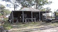
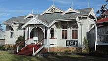
The Stanthorpe Heritage Museum at 12 High Street has a number of heritage buildings relocated to the museum site and a large number of displayed items from the district's history, many unique to the Granite Belt. The relocated buildings include:[28]
- a shepherd's hut from the Ballandean Station (built 1876)
- the old gaol from Willsons Downfall (built 1876)
- the old North Maryland school residence (built 1894)
- the old Stanthorpe Shire Council Chambers (built in 1914)
- Ardmore House, a summer holiday house (built 1920)
- Heath House, a residence (built 1940)
Annual events
There are many local events, including the Australian Small Winemakers Show,[29] the biennial Apple & Grape Harvest Festival,[30] Ballandean Estates' Opera in the Vineyard and the Stanthorpe Show.[31]
_taken_from_Mt_Marlay_lookout%2C_Lock_Street_Stanthorpe_Queensland_Australia.jpg)
Media
Rebel FM 97.1 MHz was Stanthorpe's first commercial FM radio station. Rebel FM has a new & classic rock music format. The Breeze broadcasts on 90.1 MHz with an easy adult contemporary & classics hits format. Both stations are part of the Rebel Media group. Toowoomba based station CFM also broadcasts in Stanthorpe on 97.9 MHz. CFM is a part of the Australia wide Southern Cross Media network.[32]
The Stanthorpe area is served by a local Community Radio Station Ten FM. The Station is currently transmitting on 98.7 MHz with a low power transmitter situated on Mount Marlay. The station has in 2011 upgraded its Stanthorpe studios with a new mixing desk, new computers and professional grade monitor speakers. Ten FM has a local focus, derived in part from the stringent rules controlling Community Radio Stations. The station transmits a broad range of programs to attract the widest audience. In particular, the station broadcasts Italoz, a weekly program with an Italian theme to cater for the many listeners around the Stanthorpe area with an Italian background.
The Border Post is the only paid local newspaper servicing the district. The Stanthorpe Border Post is relied upon for its coverage of local news and events.
Stanthorpe is also serviced by a Christian radio network rebroadcasting on FM 88.0 MHz. It features programs about health, lifestyle, children's programs and interesting interviews.
Tourism
Stanthorpe and the surrounding Granite Belt and Granite Highlands area of South East Queensland and Northern New South Wales are the centre of a booming winery and national parks tourist destination. There are more than 50 wineries in the Granite Belt area. The Granite Belt national parks are Girraween, Bald Rock, Sundown, and Boonoo Boonoo. The region operates its own wine and tourism marketing body named Granite Belt Wine Country.
There is a wide range of restaurants, accommodation places and other tourist venues. Backpacking is popular and there is large demand for fruit and vegetable pickers from November until May each year.[33]
Several private art galleries operate in Stanthorpe including the Glen Aplin Art Gallery which supports emerging artists and musicians who wish to display new works and perform at public functions.[34][35]
Storm King Dam offers some good angling opportunities for Murray cod, yellowbelly and silver perch.
Amenities
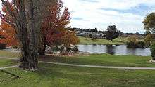
Parkland has been developed along both sides of Quart Pot Creek as it flows through Stanthorpe with a network of paths for walking and cycling with bridges and other crossings.[36]
The Southern Downs Regional Council operates the Stanthorpe Civic Centre Complex and council offices in Marsh Street (28.6539°S 151.9339°E).[37]
The Stanthorpe branch of the Queensland Country Women's Association has its rooms at 5 Victoria Street.[38]
Education
Stanthorpe State School is a government primary (Early Childhood-6) school for boys and girls at Marsh Street (28.6498°S 151.9343°E).[39][40] In 2017, the school had an enrolment of 308 students with 33 teachers (27 full-time equivalent) and 22 non-teaching staff (13 full-time equivalent).[41] It includes a special education program.[39]
Stanthorpe State High School is a government secondary (7–12) school for boys and girls at 2 McGlew Street (28.6456°S 151.9317°E).[39][42] In 2017, the school had an enrolment of 653 students with 57 teachers (53 full-time equivalent) and 45 non-teaching staff (31 full-time equivalent).[41] It includes a special education program.[39]
St Joseph's Catholic School is a private primary and secondary (Prep-12) school at 100 High Street (28.6528°S 151.9381°E).[39][43]
Queensland College of Wine Tourism offers Bachelor level degrees. The college operates in co-operation with the local Stanthorpe State High School,[44] as well as other regional schools, prtovide secondary, undergraduate, and graduate certification related to wine and tourism industries.[13]
Transport
Stanthorpe is on the Southern railway line. However, as at 2015, there are no scheduled passenger services operating to Stanthorpe railway station. The Southern Downs Steam Railway operates a tourist steam train most months from Warwick to Wallangarra & return, stopping in Stanthorpe.
Stanthorpe Airport is a public airport operated by the Southern Downs Regional Council. There are no regular scheduled services to Stanthorpe.
Notable people
- Jordan Atkins – Rugby League player for the Gold Coast Titans and Parramatta Eels
- John Alexius Bathersby – former Roman Catholic Archbishop of Brisbane
- James Blundell – country music singer
- Ben Dark – television presenter, Getaway, Nine Network
- Jerome Davidi Roman Catholic Priest considered to be influential in establishing the fruit industry in the Granite Belt in the 1870s and 1880s[45]
- Jack Drake – bush poet[46]
- Michael Hancock – former professional rugby league footballer for the Brisbane Broncos, Queensland and Australia
- Edith Elizabeth Harslett born 1888 London, died 1945 Stanthorpe. One of the few successful soldier settlers and very active in social affairs of the district.[47][48]
- Billy Moore – former professional rugby league footballer for the North Sydney Bears, Queensland and Australia
- Greg Ritchie – Australian Test and one-day international cricketer
- Tracey Wigginton – Murderer that moved to Stanthorpe
References
- Australian Bureau of Statistics (27 June 2017). "Stanthorpe (SSC)". 2016 Census QuickStats. Retrieved 20 October 2018.

- "Stanthorpe - town in Southern Downs Region (entry 32197)". Queensland Place Names. Queensland Government. Retrieved 17 November 2019.
- "Stanthorpe - locality in Southern Downs Region (entry 45978)". Queensland Place Names. Queensland Government. Retrieved 17 November 2019.
- "Stanthorpe" (Web article). Melbourne: The Age. 8 February 2004. Archived from the original on 13 October 2008. Retrieved 17 February 2008.
- "Queensland Globe". State of Queensland. Retrieved 8 June 2015.
- "Archived copy". Archived from the original on 19 September 2016. Retrieved 18 August 2016.CS1 maint: archived copy as title (link)
- Queensland Family History Society (2010), Queensland schools past and present (Version 1.01 ed.), Queensland Family History Society, ISBN 978-1-921171-26-0
- "St Joseph's School Stanthorpe Website". St Joseph's School, Stanthorpe. Archived from the original on 4 March 2019. Retrieved 24 November 2019.
- Kerr, J.D. (December 1970). "The Centenary of the Southern Line". Australian Railway Historical Society Bulletin: 261–291.
- "Stanthorpe Post Office". Register of the National Estate. Australian Government. Archived from the original on 24 September 2015. Retrieved 6 June 2015.
- "Other Attractions". Southern Downs Regional Council. Archived from the original on 10 June 2015. Retrieved 10 June 2015.
- "Stanthorpe Post Office". Australian Heritage Places Inventory. Archived from the original on 10 June 2015. Retrieved 10 June 2015.
- "Queensland College of Wine Tourism". University of Southern Queensland. 19 July 2009. Archived from the original on 2 December 2010. Retrieved 26 December 2010.
- "El Arish (entry 601633)". Queensland Heritage Register. Queensland Heritage Council. Retrieved 13 July 2013.
- "Masel Residence (former) (entry 601552)". Queensland Heritage Register. Queensland Heritage Council. Retrieved 13 July 2013.
- "Central Hotel (entry 600830)". Queensland Heritage Register. Queensland Heritage Council. Retrieved 13 July 2013.
- "Stanthorpe Post Office (Place ID 105524)". Australian Heritage Database. Department of the Environment. Retrieved 1 October 2018.
- "Sundown Tin and Copper Mine (entry 602209)". Queensland Heritage Register. Queensland Heritage Council. Retrieved 13 July 2013.
- "Stanthorpe Soldiers Memorial (entry 601632)". Queensland Heritage Register. Queensland Heritage Council. Retrieved 13 July 2013.
- "Quart Pot Creek Rail Bridge (entry 600829)". Queensland Heritage Register. Queensland Heritage Council. Retrieved 13 July 2013.
- "Cherry Gully Tunnel (entry 601517)". Queensland Heritage Register. Queensland Heritage Council. Retrieved 13 July 2013.
- "Queensland Extremes" (PDF). Australian Bureau of Meteorology. 30 September 2010. Archived (PDF) from the original on 13 October 2016. Retrieved 26 December 2010.
- "Thick snow blankets parts of southern Queensland in what could be state's most significant snowfall in 30 years". ABC News. 17 July 2015. Archived from the original on 17 July 2015. Retrieved 17 July 2015.
- "Stanthorpe Leslie Parade". Climate statistics for Australian locations. Bureau of Meteorology. Retrieved 12 January 2019.
- "Libraries". Southern Downs Regional Council. Archived from the original on 10 June 2015. Retrieved 10 June 2015.
- "Stanthorpe Regional Art Gallery". Southern Downs Regional Council. Archived from the original on 13 January 2016. Retrieved 10 June 2015.
- "The Queensland Libraries Statistical Bulletin 2016–17" (PDF). Public Libraries Connect. November 2017. Archived (PDF) from the original on 30 January 2018. Retrieved 19 January 2018.
- Stanthorpe Heritage Museum (brochure). Stanthorpe & District Historical Society.
- "Australian Winemakers Show". Australian Small Winemakers Show. Archived from the original on 17 February 2011. Retrieved 26 December 2010.
- "Apple & Grape Harvest Festival". Stanthorpe Festivals Association. Archived from the original on 5 February 2011. Retrieved 26 December 2010.
- "Show Listing". countryshows.com.au. Archived from the original on 6 January 2017. Retrieved 5 January 2017.
- theradio.com.au
- "BEST Employment Harvest Labour". Best Employment Ltd. Archived from the original on 14 January 2014. Retrieved 28 December 2013.
- "The Gallery". Glen Alpin Gardens. Archived from the original on 15 February 2017. Retrieved 27 February 2017.
- "Artworks on display at new exhibition opening". Warwick Daily News. 23 February 2017. Archived from the original on 27 February 2017. Retrieved 27 February 2017.
- "Quart Pot Creek". Queensland Government. Archived from the original on 24 September 2015. Retrieved 10 June 2015.
- "Stanthorpe Civic Centre Complex". Southern Downs Regional Council. Archived from the original on 10 June 2015. Retrieved 6 January 2018.
- "Branch locations". Queensland Country Women's Association. Archived from the original on 26 December 2018. Retrieved 26 December 2018.
- "State and non-state school details". Queensland Government. 9 July 2018. Archived from the original on 21 November 2018. Retrieved 21 November 2018.
- "Stanthorpe State School". Archived from the original on 16 March 2012. Retrieved 21 November 2018.
- "ACARA School Profile 2017". Archived from the original on 22 November 2018. Retrieved 22 November 2018.
- "Stanthorpe State High School". Archived from the original on 21 April 2013. Retrieved 21 November 2018.
- "St Joseph's School". Archived from the original on 30 October 2018. Retrieved 21 November 2018.
- "Queensland College of Wine Tourism". Archived from the original on 17 February 2011. Retrieved 26 December 2010.
- Hui, Jin (30 July 2014). "Fruit industry pioneer a priest". Southern Free Times. Archived from the original on 26 July 2019. Retrieved 24 November 2019.
- "Archived copy". Archived from the original on 4 December 2015. Retrieved 13 January 2015.CS1 maint: archived copy as title (link)
- Macmaurice, Robert (28 October 2014). "Local life: Edith Harslett". Stanthorpe Border Post. Retrieved 24 November 2019 – via PressReader.
- "When the tough get going ." Stanthorpe Border Post. 4 November 2014. Retrieved 24 November 2019 – via PressReader.
External links
| Wikimedia Commons has media related to Stanthorpe, Queensland. |
- "Stanthorpe". Queensland Places. Centre for the Government of Queensland, University of Queensland.
- Town map of Stanthorpe, 1980 (Northern part)
- Town map of Stanthorpe, 1981 (Southern part)
| Authority control |
|
|---|