Sierra Nevada del Cocuy
The Sierra Nevada del Cocuy Chita o Guican National Natural Park (or Sierra Nevada de Chita or Sierra Nevada de Güicán, Spanish: Parque Natural Sierra Nevada del Cocuy Chita o Guican is a national park and a set of highlands within the Cordillera Oriental mountain range in the Andes Mountains of Colombia.
| Parque Natural Sierra Nevada del Cocuy, Chita o Guican | |
|---|---|
| Sierra Nevada del Cocuy, Chita o Guican National Natural Park | |
IUCN category II (national park) | |
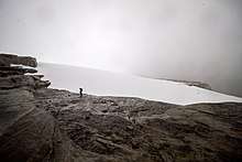
 Pan de Azúcar (5120 m) in the Sierra Nevada del Cocuy | |
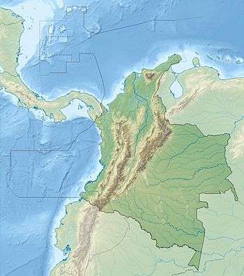 | |
| Location | Departments of Arauca, Boyacá and Casanare |
| Nearest city | Tame, Arauca, Colombia |
| Coordinates | 06°26′00″N 72°17′00″W |
| Area | 3,062 km2 (1,182 sq mi) |
| Established | 1977 |
| Governing body | SINAP |
Snow peaks
The Park area contains several high peaks covered with snow:[1]
Pan de Azúcar (5120m), Diamante (4800 m), el Púlpito del Diablo (5100 m), Toti (4800 m), Portales (4800 m), Cóncavo (5200 m), Concavito (5100 m), San Pablines South (5180 m) and North (5200 m), Ritacuba Blanco (5330 m), Picacho (5030 m), Puntiagudo (5200 m), Ritacuba Negro (5300 m), el Castillo (5100 m), peak without name (5000 m), Sirara (5200 m).
An 1856 watercolor by Manuel María Paz is an early depiction of the Sierra Nevada del Cocuy in Casanare Province.[2]
Native peoples
Indigenous natives of the region are the U'wa (Tunebos) and their reservation overlaps the area of the park and thus part of the park is dedicated to their farming, grazing, hunting and fishing activities.[3][4]
From 1969 to 1977 in the area of the park and the surrounding area, the Colombian government promoted colonisation from elsewhere in Colombia. This resulted in loss of U'wa lands as well as other settlement enclaves within the park.[3]
Regional geology
| Age | Paleomap | VMM | Guaduas-Vélez | W Emerald Belt | Villeta anticlinal | Chiquinquirá- Arcabuco | Tunja- Duitama | Altiplano Cundiboyacense | El Cocuy | ||||
|---|---|---|---|---|---|---|---|---|---|---|---|---|---|
| Maastrichtian |  | Umir | Córdoba | Seca | eroded | Guaduas | Colón-Mito Juan | ||||||
| Umir | Guadalupe | ||||||||||||
| Campanian | Córdoba | ||||||||||||
| Oliní | |||||||||||||
| Santonian | La Luna | Cimarrona - La Tabla | La Luna | ||||||||||
| Coniacian | Oliní | Conejo | Chipaque | ||||||||||
Güagüaquí | Loma Gorda | undefined | La Frontera | ||||||||||
| Turonian |  | Hondita | La Frontera | Otanche | |||||||||
| Cenomanian | Simití | hiatus | La Corona | Simijaca | Capacho | ||||||||
| Pacho Fm. | Hiló - Pacho | Churuvita | Une | Aguardiente | |||||||||
| Albian |  | Hiló | Chiquinquirá | Tibasosa | Une | ||||||||
| Tablazo | Tablazo | Capotes - La Palma - Simití | Simití | Tibú-Mercedes | |||||||||
| Aptian | Capotes | Socotá - El Peñón | Paja | Fómeque | |||||||||
| Paja | Paja | El Peñón | Trincheras | Río Negro | |||||||||
| La Naveta | |||||||||||||
| Barremian |  | ||||||||||||
| Hauterivian | Muzo | Cáqueza | Las Juntas | ||||||||||
| Rosablanca | Ritoque | ||||||||||||
| Valanginian | Ritoque | Furatena | Útica - Murca | Rosablanca | Girón | Macanal | |||||||
| Rosablanca | |||||||||||||
| Berriasian |  | Cumbre | Cumbre | Los Medios | Guavio | ||||||||
| Tambor | Arcabuco | Cumbre | |||||||||||
| Sources | |||||||||||||
Notes and references
- "El Cocuy Boyacá"(in Spanish) (Retrieved on January 6, 2008)
- Paz, Manuel María. "View of the Sierra Nevada del Cocuy, Chita, or Güicán, from Moreno, Province of Casanare". World Digital Library. Retrieved 2014-05-21.
- Cabrero, Ferran (ed.). "U'wa Dossier". UNESCO Centre de Catalunya (UNESCO Center of Catalonia). Archived from the original on 27 September 2007.
- "Comunicado del pueblo Uwa denuncia la incapacidad de Parques Nacionales Naturales de Colombia". Radio Macondo (in Spanish). 19 March 2016. Archived from the original on 5 May 2016.
External links

Mountain ranges of Colombia | ||||||||||
|---|---|---|---|---|---|---|---|---|---|---|
| Colombian Andes |
| .svg.png) | ||||||||
| Isolated ranges | ||||||||||
.svg.png)
Treasures of Colombia | |||||||||||||||||||||||||||||
|---|---|---|---|---|---|---|---|---|---|---|---|---|---|---|---|---|---|---|---|---|---|---|---|---|---|---|---|---|---|
| |||||||||||||||||||||||||||||
| |||||||||||||||||||||||||||||
| |||||||||||||||||||||||||||||
| |||||||||||||||||||||||||||||
Source: Wills, Fernando et al. 2001. Nuestro patrimonio - 100 tesoros de Colombia - Our heritage - 100 treasures of Colombia, 1–311. El Tiempo.ISBN 958-8089-16-6 | |||||||||||||||||||||||||||||