Caquetá Department
Caquetá Department (Spanish pronunciation: [kakeˈta]) is a department of Colombia. Located in the Amazonas region, Caquetá borders with the departments of Cauca and Huila to the west, the department of Meta to the north, the department of Guaviare to the northeast, the department of Vaupés to the east, the departments of Amazonas and Putumayo to the south covering a total area of 88,965 km², the third largest in the country. Its capital is the city of Florencia.
Department of Caquetá Departamento del Caquetá | |
|---|---|
 Flag  Coat of arms | |
| Motto(s): All, For a Better Caqueta (Spanish: Todos por un Caquetá mejor) | |
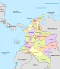
.svg.png) Caquetá shown in red | |
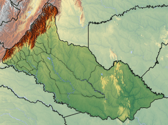 Topography of the department | |
| Coordinates: 1°37′N 75°36′W | |
| Country | |
| Region | Amazonas Region |
| Established | 1982 |
| Capital | Florencia |
| Government | |
| • Governor | Alvaro Pacheco Alvarez (2016-2019) |
| Area | |
| • Total | 88,965 km2 (34,350 sq mi) |
| Area rank | 3rd |
| Population (2018)[1] | |
| • Total | 401,849 |
| • Rank | 24th |
| • Density | 4.5/km2 (12/sq mi) |
| Time zone | UTC-05 |
| ISO 3166 code | CO-CAQ |
| Municipalities | 15 |
| HDI (2017) | 0.700[2] high · 25th |
| Website | |
| Historical population | ||
|---|---|---|
| Year | Pop. | ±% |
| 1973 | 180,297 | — |
| 1985 | 264,507 | +46.7% |
| 1993 | 367,898 | +39.1% |
| 2005 | 420,337 | +14.3% |
| 2018 | 401,849 | −4.4% |
| Source:[3] | ||
Municipalities
See also
References
- "DANE". Archived from the original on November 13, 2009. Retrieved February 13, 2013.
- "Sub-national HDI - Area Database - Global Data Lab". hdi.globaldatalab.org. Retrieved 2018-09-13.
- "Reloj de Población". DANE. Departamento Administrativo Nacional de Estadísitica. Retrieved 6 July 2017.
External links
- (in Spanish) Government of Caquetá official website
- (in Spanish) Secretary of Health of Caquetá
- (in Spanish) Portal de información recreativa y cultural de Florencia y el Departamento del Caquetá.
- Territorial-Environmental Information System of Colombian Amazon SIAT-AC website
- (in Spanish) Portal Positivo del Caquetá
- (in Spanish) Clasificados del Caquetá
 | ||
| Authority control |
|
|---|
This article is issued from Wikipedia. The text is licensed under Creative Commons - Attribution - Sharealike. Additional terms may apply for the media files.